
 Worksheets
Climate Variables
Total questions: 36
Worksheet time: 18mins
What factors contribute to the different climate regions on Earth?
Latitude and ocean currents
Soil type and animal species
Types of rocks and minerals
Population density and urban development
How does climate differ from weather?
Climate is more variable than weather
Climate is the same as weather
Climate refers to long-term atmospheric conditions, while weather refers to short-term changes
Weather refers to long-term atmospheric conditions, while climate refers to short-term changes
What does the term "climate" refer to?
Daily weather conditions
A region's overall weather condition over a long period of time
A brief period of rainfall
Changes in temperature over a week
Which of the following is NOT a factor affecting climate according to the learning material?
Soil type
Latitude
Ocean currents
Vegetation
What factor related to water bodies influences climate?
River flow
Ocean currents
Waterfall presence
Lake size
Which factor listed affects climate due to its impact on air movement and pressure?
Planetary wind and pressure belts
Forest density
Urban areas
Desert location
How does elevation influence climate?
Higher elevations are typically warmer
Lower elevations receive more sunlight
Higher elevations are typically cooler
Elevation has no impact on climate
What effect does latitude have on the angle of insolation and temperature?
Low latitudes have a low angle of insolation, resulting in lower temperatures.
High latitudes have a high angle of insolation, resulting in higher temperatures.
Low latitudes have a high angle of insolation, resulting in higher temperatures.
High latitudes have a low angle of insolation, resulting in higher temperatures.

What does the color gradient in the image primarily represent in relation to geographic locations?
Population density
Elevation levels
Temperature variations
Rainfall distribution

Which latitude range is likely to experience the highest temperatures according to the color gradient in the image?
Near the poles
Near the equator
Mid-latitudes
None of the above

Based on the image, which continent shows extensive areas of high temperature?
Antarctica
North America
Africa
Europe
What causes prevailing winds on Earth?
Rotation of the Earth
Gravitational forces from the moon
Pressure differences
Solar radiation
Which direction do the prevailing winds blow in the United States?
Northeasterly
Southwesterly
Southeasterly
Northwesterly
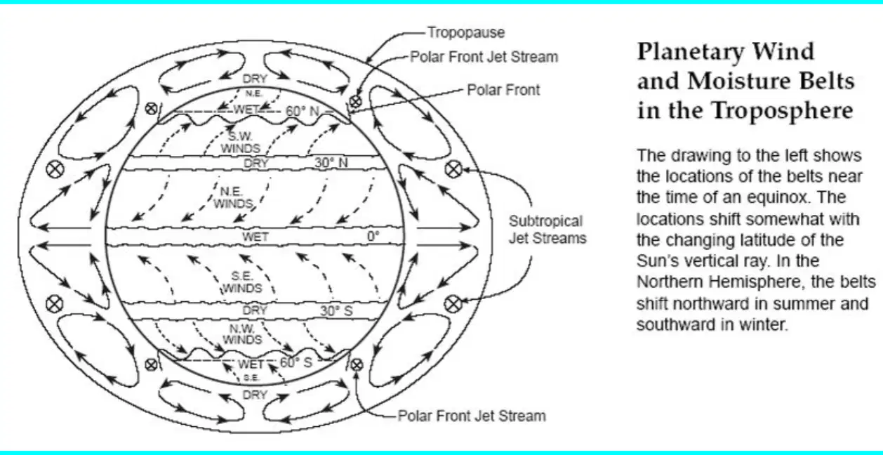
What is the primary subject of the diagram provided in the image?
Ocean currents and their effects on climate
Planetary wind and moisture belts in the troposphere
Types of clouds and precipitation
Earth's magnetic field variations

What natural phenomenon marks the 0° latitude shown in the diagram?
The Tropic of Cancer
The Arctic Circle
The Equator
The Prime Meridian
What effect does low pressure at the equator have on the atmosphere?
It causes air to sink and form arid regions
It causes air to rise, expand, cool, and condense to form clouds and rain
It increases the moisture content uniformly across the globe
It has no significant effect on the atmosphere
What does high pressure typically cause in terms of atmospheric conditions?
Formation of dense forest areas
Increased rainfall and cloud cover
Air to sink and form arid regions
Air to rise and cool rapidly

What color on the map indicates areas that receive under 250 mm of precipitation annually?
Yellow
Green
Brown
Blue

Which area on the map receives the highest amount of precipitation, over 2000 mm annually?
Areas colored light green
Areas colored dark green
Areas colored yellow
Areas colored brown
What role do large bodies of water like oceans, seas, lakes, and bays play in climate regions?
They increase the rate of heating and cooling of water
They have no significant effect on climate regions
They serve to modify climate regions
They prevent any climate change
How does the proximity of land masses to large bodies of water affect their climate?
It causes rapid temperature fluctuations
It regulates the climate by the slow rate of heating and cooling of water
It leads to higher pollution levels
It increases land erosion

Which direction do warm ocean waters flow according to the image on ocean currents?
From the poles towards warmer regions
From the equator towards colder regions
From the equator towards warmer regions
From colder regions towards the equator

According to the image, how do cold ocean waters generally flow?
From the equator towards colder regions
From the poles towards warmer regions
From warmer regions towards the poles
From colder regions towards the equator

What type of ocean current is represented by the dashed lines on the map?
Warm currents
Cool currents
Static currents
Deep ocean currents

Which ocean current flows along the west coast of South America?
North Equatorial Current
South Equatorial Current
Peru Current
Florida Current

What is the direction of the North Atlantic Current according to the map?
From North America to Europe
From Europe to North America
From South America to Africa
From Africa to South America

Which current is found flowing near the Arctic Circle as shown on the map?
Gulf Stream
Labrador Current
East Greenland Current
West Australian Current
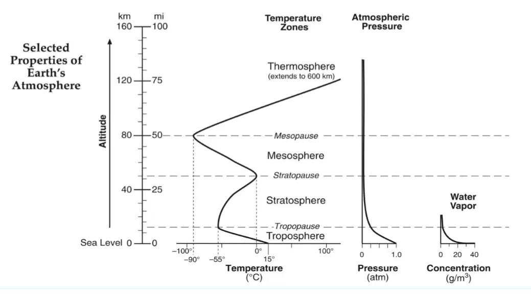
What is the trend of atmospheric pressure as altitude increases, based on the diagram?
Increases then decreases
Decreases then increases
Constantly increases
Constantly decreases
What happens to the air as it rises up a mountain?
It cools and condenses, creating a cooler, more moist region.
It heats up and evaporates, creating a drier region.
It remains stable and unchanged in temperature and moisture.
It increases in pressure and moisture.
What effect do mountains have on planetary winds?
They have no effect on planetary winds.
They block all wind flow, creating stagnant air.
They intersect and modify climate regions.
They increase the speed of the winds.
What occurs as the winds descend the mountain?
The air cools and gains moisture.
The moisture in the air is lost, creating a warm and dry region.
The air pressure increases significantly.
The air becomes cooler and wetter.

What does the diagram illustrate about the pressure distribution around a mountain when wind is present?
Equal pressure on both sides of the mountain
Higher pressure on the windward side and lower pressure on the leeward side
Lower pressure on both sides of the mountain
Higher pressure on the leeward side and lower pressure on the windward side
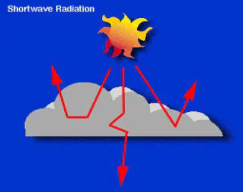
What happens to sunlight when clouds are present during the daytime?
Sunlight is completely absorbed by the clouds.
Sunlight is blocked and heat energy is radiated back into space.
Sunlight passes through the clouds without any interference.
Sunlight is used by the clouds to produce rain.

What is the effect of no clouds on sunlight reaching the Earth's surface during the daytime?
Sunlight is scattered in multiple directions and does not reach the surface.
Sunlight is mostly absorbed by the atmosphere.
Sunlight reaches the Earth's surface and warms it.
Sunlight is reflected back into space without warming the surface.

What happens to heat energy at night when there are clouds in the sky?
Heat energy is trapped and not allowed to re-radiate back into space
Heat energy is completely lost to space
Heat energy is used to warm the clouds
Heat energy increases the Earth's temperature significantly
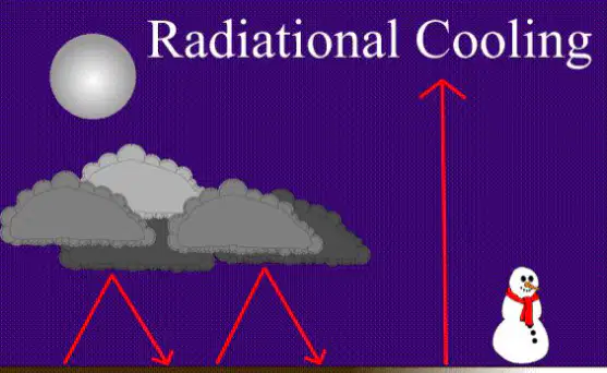
What is the effect on heat energy during a clear, cloudless night?
Heat energy is trapped and increases the Earth's temperature
Heat energy is allowed to escape and re-radiate back into space
Heat energy is absorbed by the moon
Heat energy is converted into light energy

