
Font size
 Worksheets
hchs j1. geography 1 & 2: maps and mapping & about the UK
Total questions: 61
Worksheet time: 52mins
What is physical geography about?
Earth, its features and natural disasters
humans, the state and placement of countries
pollution, climate change, global warming and our effects on Earth
the study of rocks, its features, its significance and how to study rocks
In which strand of geography do we learn about how and where we live, how our numbers are growing, how we earn a living, how and why some countries are poorer than others?
(a)
In which strand of geography do we learn about our impact on our surroundings, pollution and global warming, and how we can fix these issues?
physical geography
human geography
environmental geography
environmental geology
physical geology
What is an example of change?
rocks break down into soil
fish eating the plastic that humans threw into the sea
humans in poverty
racism
In which theme of geography does poverty fall into?
(a)
"We are warming Earth up by burning fossil fuels."
In which theme of geography does this statement fall into?
change
impact
equality
inequality
"noun: a physical drawing of a place from above, showing the physical features of that land accurately"
what is this?
photograph
satellite image
map
Google Earth
GIS

1.
North
South
East
West
3.
North
South
East
West
5.
North
South
East
West
7.
North
South
East
West
2.
Northeast
Southeast
Northwest
Southwest
4.
Northeast
Southeast
Northwest
Southwest
6.
Northeast
Southeast
Northwest
Southwest
8.
Northeast
Southeast
Northwest
Southwest
The sun rises in the 1.____ and sets in the 2.____.
1. north, 2. south
1. west, 2. east
1. east, 2. west
1. south, 2. north
In which country was the compass invented in?
US
UK
China
Russia
What does the accuracy of a map depend on?
How much the map maker knows about the place
How large or small the map is
How many places in the map there are
How carefully it has been measured
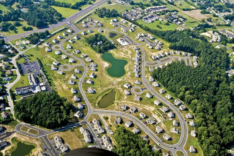
What type of photograph is this?
(a)

What type of photograph is this?
(a)
How do you snap an aerial photo?
tripod
planes
selfie stick
balloons
drones
What are ground photos?
a photo that you take with your hand that captures your face
a photo taken at ground level
a photo taken of the ground
a photo taken in the sky
What are images taken from high above Earth by sensors in space that orbit planets and can cover large areas?
(a)
What do you use satellite images for?
travelling through cities
tracking hurricanes and wildfires
spying
telling directions
What does GIS stand for?
(a)
What does Google Earth combine in order to visualise a place?
I. maps
II. satellite images
III. history
IV. photos
V. 3D images
all of the above
none of the above
I, II, IV, V
I, II, IV
II, IV, V
What is a natural resource?
An area of land set aside for wild animals, where they can be protected
A cold region where the ground is deeply frozen; only the surface thaws in summer. allowing small plants to grow
Crops that farmers grow to sell, rather than use for themselves
A resource which occurs in nature and which we can make use of
"A narrow valley with steep sides."
What does the statement above define?
(a)
What is the current industry of Ironbridge Gorge?
agriculture
iron industry
tourism
trade

What was an astrolabe used for?
Measuring the angle between a star and the horizon
Showing a place from above
Doing calculations with different sets of data
Telling directions like north, south, east, and west
What is GPS?
(a)
I. This allows us to analyse maps and use them for surveying or navigating.
II. This allows us to analyse radio waves sent by satellites and use them for surveying or navigating.
Which of these describe GPS and/or GIS?
GPS: I
GIS: II
GIS: I
GPS: II
GIS: I, II
GPS: I, II
GIS: I, II
GPS: II
What is a mental map?
A map that you draw out
A map that is created by satellites
A map that is created by aerial photos
A map that you make in your head
Above a map, "The River Mole valley near Mickleham" is written.
Of the 5 features of a good map, which one is this?
(a)

What is the answer to question 1?
(a)
What is a feature of a good map?
a frame around the map
a frame inside the map
a frame above the map
a frame below the map
In a map, what is needed to show the direction of the map?
(a)

Of the 5 features of a good map, which is this?
(a)
To turn a photo to a map, which type of photograph is required?
ground photo
aerial photo
selfie
potrait
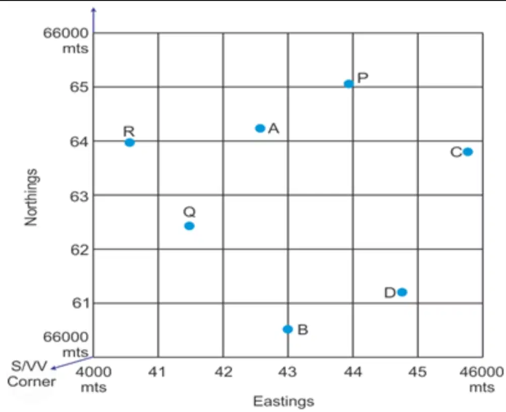
Name the four-figure grid reference of R.
(a)
Name the four-figure grid reference of C.
(a)
Name the four-figure grid reference of P.
(a)
Name the four-figure grid reference of B.
(a)

In which six-figure grid reference is the car park?
(a)
In which six-figure grid reference is the church furthest from the car park?
(a)
In which six-figure grid reference is the bridge closest to a church?
(a)
" '(_)' means the straight line distance between two places."
Fill in the blank.
(a)
Is the road longer if you measure it as the crow flies, or by road?
(a)
Instead of contour lines, what else can you use to determine the height of a place on the map?
(a)
From where does a river start to flow?
(a)
"Where contour lines are very far apart, it means the ground is (flat/bumpy) and slopes gently."
Write the correct answer.
(a)
"When contour lines are very close together, it means that the ground slopes (steeply/gently)."
(a)
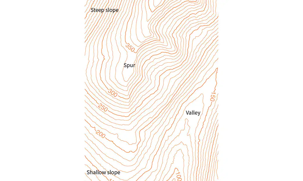
What is the contour interval for this map?
(a)
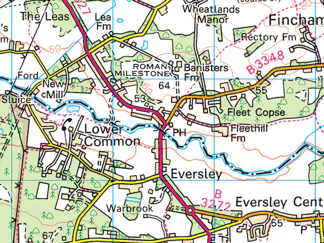
What is the direction of Rectory FM from Eversley?
(a)
Where is the Prime Meridian?
longitude 0°
latitude 0°
East 0°
West 0°
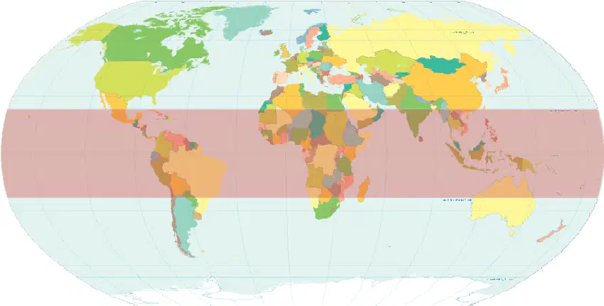
What is the place highlighted in red called?
(a)
"The (_) has a latitude of 0°. Lines to the North of it are labelled N, lines to the South of it are labelled S."
Fill in the blank.
(a)
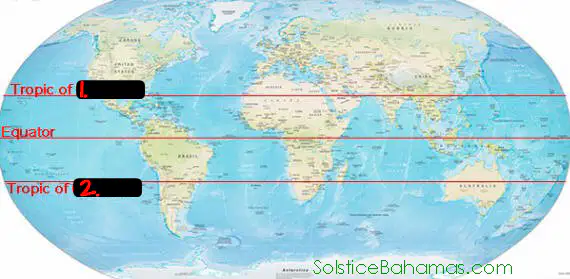
1. What is the tropic above the Equator?
(a)
2. What is the tropic below the Equator?
(a)
Where is the South Pole located?
Tropic of Cancer
Tropic of Capricorn
Artic Circle
Antarctic Circle
What are the characteristics of the Arctic Circle?
the North Pole is in it
the South Pole is in it
its coordinates are 66° 33'N
its coordinates are 66° 33'S

