
 Worksheets
Africa Geo & History Mastery Review
Total questions: 37
Worksheet time: 37mins
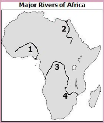
Which number on the map represents the Niger River?
A. 3
B. 2
C. 4
D. 1

Refer to the diagram titled "Major Rivers of Africa". Which number on the map represents the Nile River?
A. 2
B. 1
C. 4
D. 3
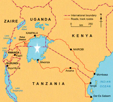
Refer to the diagram showing a map of parts of Africa including Zaire, Uganda, Kenya, and Tanzania. Identify the starred feature on the map.
A. Lake Victoria
B. Mount Kilimanjaro
C. Niger River
D. Sahara Desert
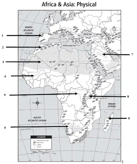
Refer to the provided map of Africa and Asia. What number on the map refers to the Sahara Desert?
A. 2
B. 3
C. 5
D. 6
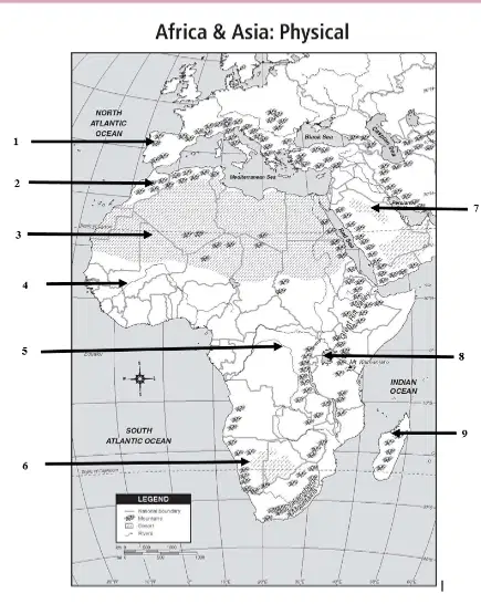
Which number on the map refers to the Atlas Mountains?
A. 4
B. 6
C. 2
D. 8
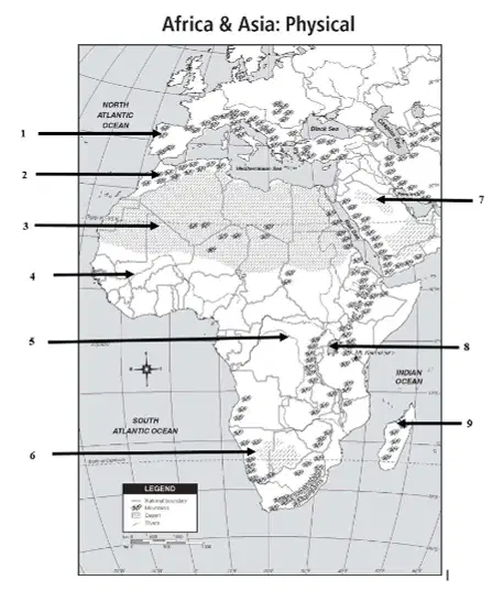
Which number on the map refers to the Kalahari Desert?
A. 2
B. 6
C. 8
D. 1
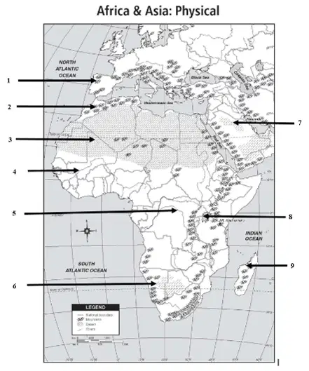
Which number on the map refers to the Congo River?
A. 4
B. 3
C. 2
D. 5
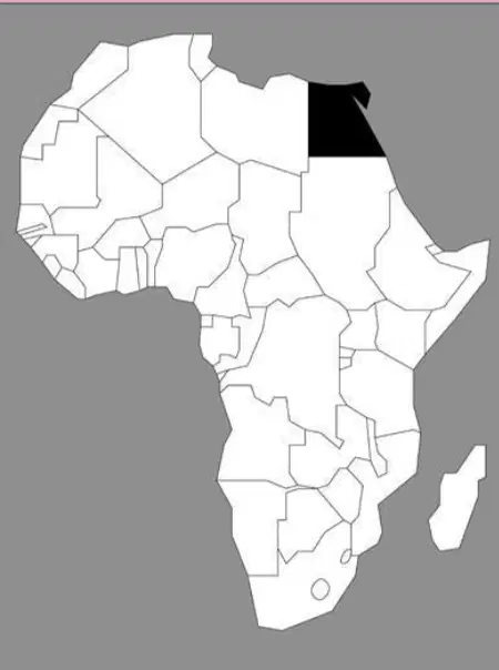
Which country is shaded in black?
Ethiopia
Algeria
Libya
Egypt
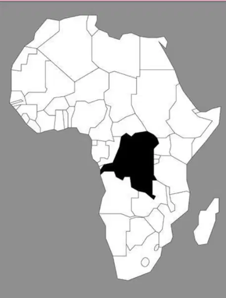
Refer to the diagram showing a map of Africa with a country shaded in black. What country is shaded in black?
Democratic Republic of Congo/Zaire
Chad
Sudan
Libya
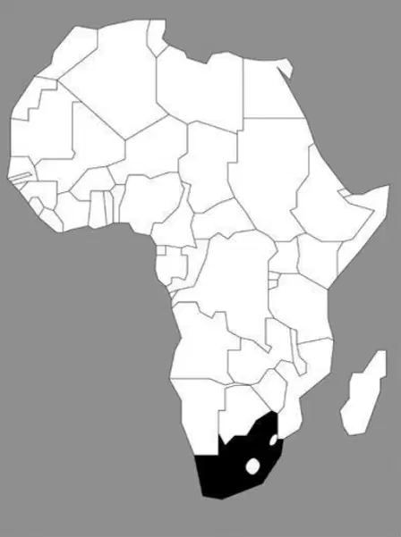
Identify the country shaded in black on the map.
Chad
Sudan
South Africa
Ethiopia
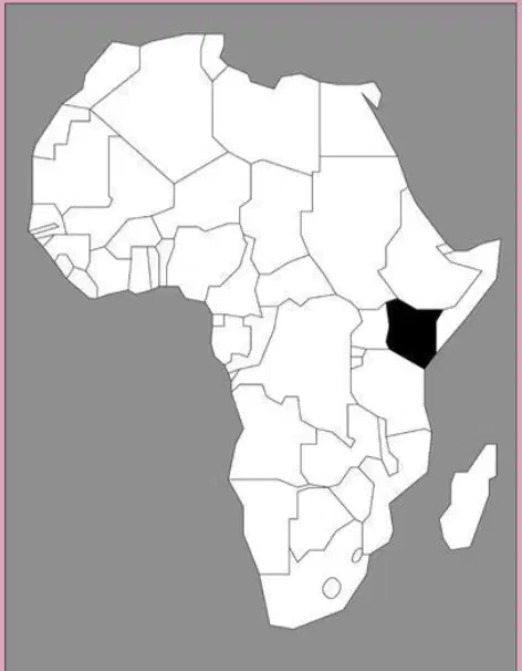
What country is shaded in black?
Kenya
Chad
Libya
Sudan
In sub-Saharan Africa, less than 50% of the population has access to safe drinking water from environmental pollution. How has this shortage of safe drinking water affected sub-Saharan African development?
decreased the size of the rainforest
increased the size of the Sahara
increased population growth
decreased population growth
What is one of the major problems facing those who depend on the Nile River for their water?
The river is too shallow to be used for transportation
The river has no fish in it
The river always dries up during the summer months
The water is contaminated with human and industrial waste
How does unequal distribution of water in sub-Saharan Africa affect the region?
It encourages industry.
It decreases oil production.
It limits economic activity.
It increases mining opportunities.
What is the largest ethnic group in Africa?
Ashanti
Arabs
Bantu
Swahili
Why have some African governments ignored industrial pollution of major rivers and waterways?
Most government officials do not recognize pollution as a problem.
They want the industries to be profitable.
Industries always have plans in place to clear up polluting wastes.
The people of most countries do not care about pollution.
Which is not an impact that deforestation has had on the Congo Basin?
It has decreased the quality of the air because the level of carbon is lower.
It has changed the climate of the region.
It has increased poaching of animals because they are more in the open.
It has increased the amount of river water helping the water animals survive.
Population growth along the southern edge of the Sahara Desert has led to extensive deforestation. The deforestation has resulted in which of the following developments?
Erosion has made much of the cleared land barren and unable to support farming.
The presence of so many farms has caused the Sahara Desert to shrink dramatically.
People have begun to move to other countries with more forests.
Tropical rain forests have grown quickly to fill the cleared areas.
What effect does poor soil and deforestation have on land in Africa?
It has created excellent archeological dig sites.
It has become a better place for urban development.
The land has become part of the national park system.
The land has become useless for farming and agriculture.
Which of these is a cause of soil erosion in Sub-Saharan Africa?
vegetation
lack of wind
deforestation
air pollution
In the Sahel, overgrazing and drought have resulted in a decrease in the grassland region. What is this process called?
desertification
unequal distribution
environmental pollution
deforestation
What is a belief in spirit in nature?
Buddhism
Animism
Hinduism
Batuism
Which of the following is NOT a contributing factor to desertification?
poor farming techniques
use of pesticides
overgrazing
extended droughts
How has desertification affected people in sub-Saharan Africa?
Farmers have learned ways to decrease their reliance on irrigation.
People have relocated as farmland became unsuitable.
Governments have built dams to conserve water resources.
Mining has become the dominant industry in the region.
What destroyed the grassland and forests that were once found in the Sahel?
A. repeated use by nomads and camel caravans
B. continuous farming and overgrazing
C. the development of factories
D. years of heavy flooding
What best describes the religion of the Bantu people?
A. the Bantu practice a wide variety of religions
B. nearly all Bantu are Christian
C. most are Muslims
D. most Bantu practice Animism
What religion is most common among the Swahili today?
A. Islam
B. Christianity
C. Buddhism
D. Hinduism
What TWO religions are the most common in Africa?
A. Islam
B. Christianity
C. Judaism
D. Hinduism
What is the significance of the Golden Stool for the Ashanti people?
A. It symbolizes the power of the Ashanti people
B. It symbolizes the Ashanti people's strong background in making furniture and household goods
C. The Ashanti people could only worship if they were sitting on the Golden Stool
D. The stool was meant to encourage equal rights for all
If you are describing someone who is a member of the Ashanti people, what are you describing?
A. Religious group
B. Territorial group
C. Migratory group
D. Ethnic group
What factors lead to the nationalist movements in many African countries?
fear of punishment from white government leaders
increased education from Africans who had been overseas
African slavery
fear of imprisonment
What was the name of Nelson Mandela's political party?
African Union
African National Congress
Kenyan National Unity Party
Zulu Nation
What decision did South African President F.W. de Klerk eventually make about the country's apartheid laws?
He recommended that laws stay the same.
He worked to spread apartheid laws to nations neighboring South Africa.
He lifted segregation restrictions on those living in South African cities.
He added many new and even harsher laws.
In 1952, Kenya was rocked with violence between black laborers and white landowners. Great Britain used its military power to put down African protests. Eventually, imprisoned nationalist leader, Jomo Kenyatta re-emerged to lead the Kenyan independence movement. In 1963, Kenya won its independence. How was the Kenya's independence movement different from Nigeria's?
Nigeria was never occupied by Great Britain so an independence movement was not necessary.
The Nigerian independence movement was achieved without bloodshed.
Great Britain chose to give up rule, and no independence movement was necessary.
The Nigerian independence movement was the bloodiest and most violent of the African independence movements.
The main goal of the Pan-African movement was to
What is the apartheid system?
western-style democracy
constitutional monarchy
segregation of races
equality for all
Which was used by Europeans to draw most of the new boundaries for African countries?
Most boundaries were drawn based on ethnic and tribal groups
Europeans followed the old colonial boundaries
They used only geographic features like rivers and mountain ranges for boundaries
Europeans simply drew straight lines on the map and made countries into squares

