
 Worksheets
Weathering, Erosion, & Maps Review
Total questions: 20
Worksheet time: 11mins
Which term refers to the process that breaks rocks into small pieces?
Deposition
Weathering
Erosion
Which term refers to the process that transports sediment, soil, and rock to another location?
Deposition
Weathering
Erosion
Which term refers to the process that deposits sediment, soil, and rock onto land?
Deposition
Weathering
Erosion

Which of the following can be a cause of erosion?
Water
Gravity
Water & Gravity
I do not know.

A sand dune gets larger as grains of sand gather together. This is an example of what?
Weathering
Erosion
Weather & Erosion
I do not know.

Burrowing bees chew through sandstone rock to make a home. This is an example of what?
Deposition
Weathering
Erosion
I do not know.
As a glacier flows over land, it picks up rocks in a process called plucking. This is an example of what?
Deposition
Weathering
Erosion
I do not know.
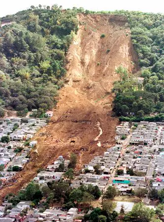
Landslides are a fast-acting type of what?
Deposition
Weathering
Erosion
I do not know.
Temperature change can cause rocks to expand and contact. Eventually, cracks may form in a rock. This is an example of what?
Chemical Weathering
Mechanical Weathering
Deposition
I do not know.
Which statement is false?
Water can be a powerful eroding force.
It takes millions of years to wear away a mountain.
Erosion is always a slow process.
I do not know.

Which statement is true?
Rocks are worn away by deposition
Weathering and erosion have the same meaning.
Water and wind can change the shape of a mountain.
I do not know.
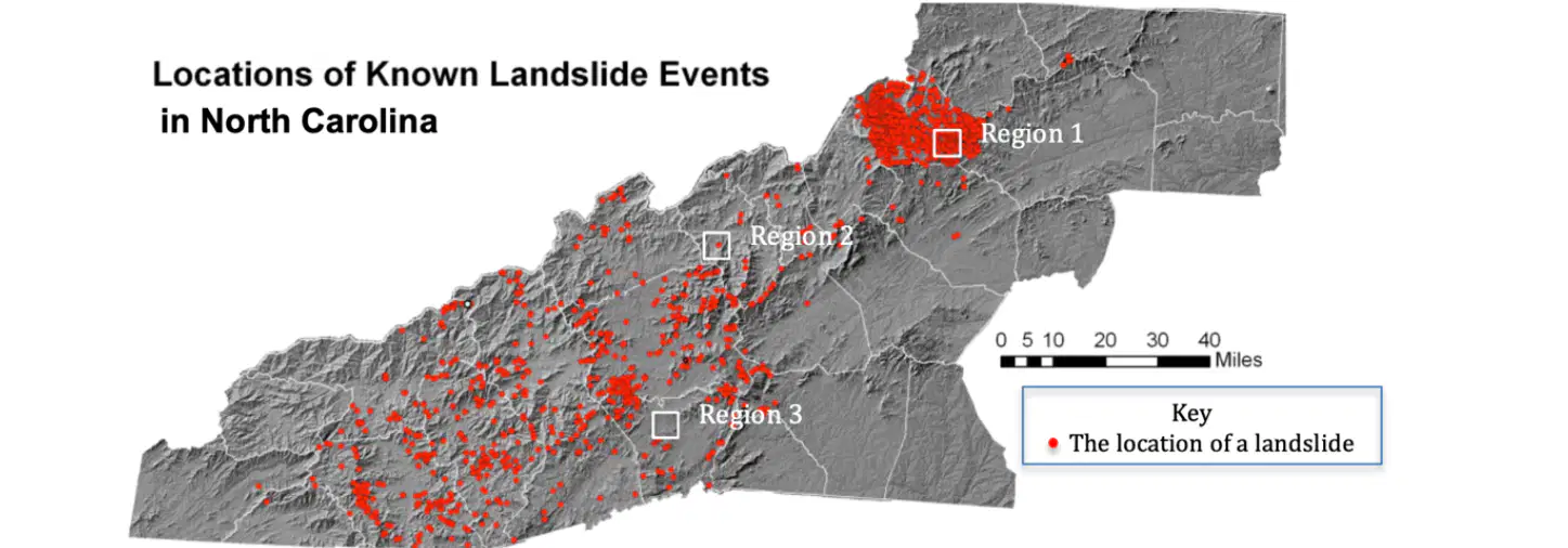
Which region on the map has the highest risk of future landslides?
Region 1
Region 2
Region 3
I do not know.
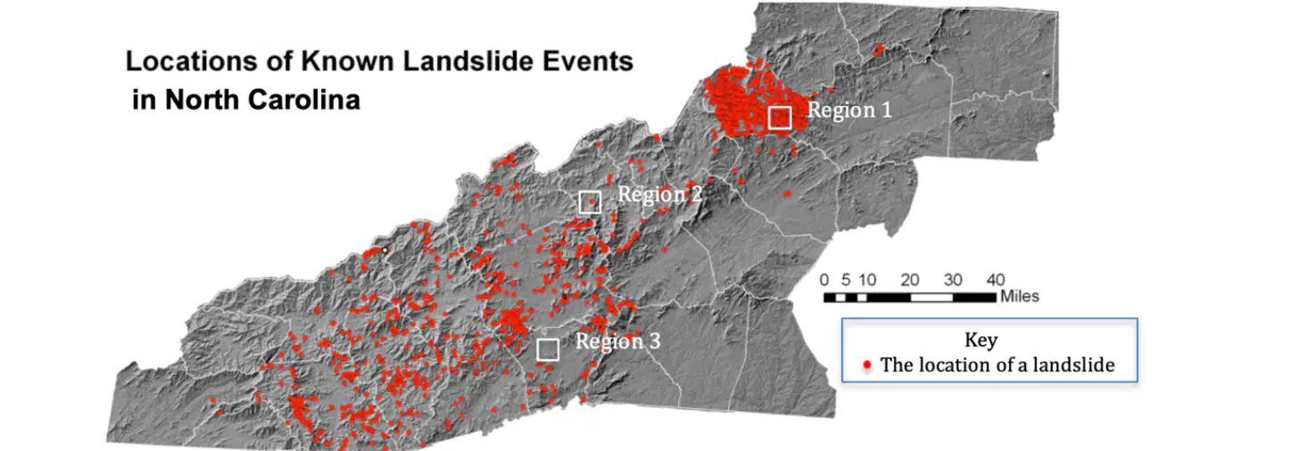
Which region on the map has the lowest risk of future landslides?
Region 1
Region 2
Region 3
I do not know.
How is the region with the highest risk of future landslides most likely different from the area with the lowest risk?
It has steeper hills.
It has more buildings and roads.
It has more snow.
It has a higher population.

Experts want to use this data to inform their preparations for future landslides. Use what you know about landslides, to help them understand the two graphs.
The higher the amount of rain during a year, the more landslides happen.
The number of landslides and the amount of rain are decreasing over time.
The number of landslides had nothing to do with the amount of rain.
Landslides happen when there is more than 100mm of rain during a year.

Which region had very few earthquakes in the past year, but the risk of future earthquakes is still high
A
B
C
D
E

In this region, the pattern of earthquakes shows that this region is at the boundary of two of the Earth’s plates.
B
C
D
E

In this region, there have been earthquakes in the past year, but there is a low risk of future earthquakes
D
E
F
A

There is a very high risk of future earthquakes & volcanoes.
B
C
D
E
Erosion and weathering are similar because they both involve the breaking down of rocks. However, what is a key difference between the two?
Erosion involves movement, while weathering does not.
Weathering can only happen with water, while erosion does not need water.
Erosion happens only on the Earth's surface, while weathering happens below the surface.
Weathering is a man-made process, while erosion is natural.

