
 Worksheets
Geography Final Review
Total questions: 54
Worksheet time: 30mins
Which mountain range divides the European and Asian sections of Russia?
Alps
Urals
Rockies
Andes
What is the significance of the Bering Strait?
Passageway that allows Democracy to come into the United States
Alaska never would have been founded without the land bridge
The first humans to arrive in America came from Asia across the land bridge
Cut the trading route in half from the Atlantic to the Pacific
Type of economic system in which the government controls all industries and decision making.
Traditional
Social
Free market
Command
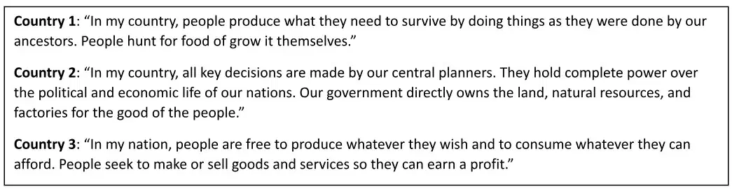
What occupation would most commonly be found in Country 1?
Subsistence farming
Mining
Computer programmers
Commercial agriculture

Which statement would be true of the economy in Country 2?
Many businesses compete to have the lowest prices.
Most people follow their parents’ occupations.
A major goal of the economy is to have a classless society.
Few people receive education or training outside the home.

A supporter of the economic system found in Country 3 would most likely agree with which statement?
All nations can benefit from cottage industries.
Revolution is the only solution to current economic problems.
A planned economy is necessary in order to industrialize.
The government should limit its interference in the economy.
The deserts of the Middle East and North Africa are characterized by populations that —
move to find resources that are thinly dispersed across a vast area
work primarily in small cottage industries
are nonviolent and practice ancient polytheistic religions
organize their society around a matriarch

Based on the map, one way that cultural diffusion has impacted the city of Jerusalem includes —
the creation of separate distinct cultural district
the blending of several religious traditions into a new one
the building of a wall to keep threatening forces out of the city
the division of the city into Palestinian and Israeli administered areas
In addition to flood control, the Aswan Dam provides Egypt with —
dominant political role in the Arab world
direct access to the Mediterranean Sea
hydroelectric power
a barrier to the expanding desert
One way that wealthy nations in Southwest Asia are able to address the lack of water is by —
Draining wetlands
Trading oil for irrigation
Constructing large dams
Building desalination plants
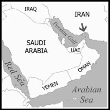
The strait indicated by the arrow on the map is one of the busiest shipping lanes in the world. What type of maritime traffic accounts for a majority of this activity?
Oil tankers
Cruise ships
Ferry boats
Naval destroyers
The Middle East’s designation as a “cultural crossroads” developed primarily as a result of the region’s -
Technological achievements
Political stability
Geographic location
Religious unity
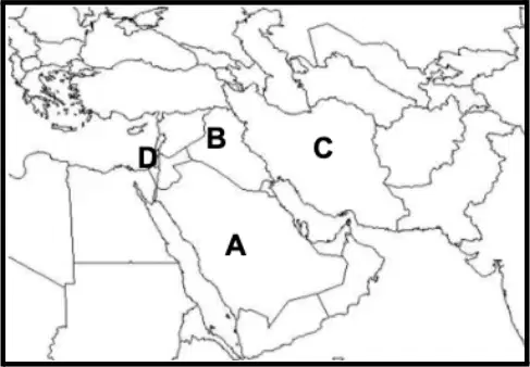
Which country is labeled as A?
Iraq
Iran
Israel
Saudi Arabia

Which country is labeled as B?
Iraq
Iran
Israel
Saudi Arabia
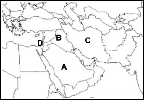
Which country is labeled as C?
Iraq
Iran
Israel
Saudi Arabia

Which country is labeled as D?
Iraq
Iran
Israel
Saudi Arabia
In modern African nations, the continued strength of the tribe or ethnic group is a reflection of -
European imperialism
urban growth
the slave trade
traditional cultures
How is Sub-Saharan Africa culturally distinct from North Africa?
Sub-Saharan Africa is home to larger Muslim populations.
Sub-Saharan Africa has been more geographically isolated.
Sub-Saharan Africa has a population that is more urbanized.
Sub-Saharan Africa is characterized by more linguistic diversity.
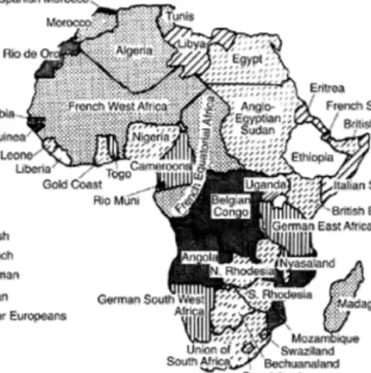
The best title for this map would be -
European Imperialism
African Nationalism
The Growth of Islam
Cold War Politics
A farm family in Kenya raises grain, vegetables, and a few chickens. They store the harvest to provide their food supply for the year, until the next harvest. They are engaging in -
commercial farming
plantation agriculture
subsistence farming
Globalization
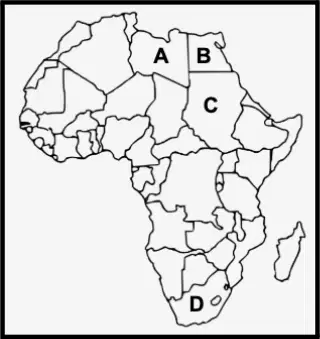
Use the map on the right to answer the following question: Which country is labeled as 'A'?
Egypt
Libya
South Africa
Sudan

Use the map on the right to answer the following question: Which country is labeled as 'B'?
Egypt
Libya
South Africa
Sudan

Use the map on the right to answer the following question: Which country is labeled as 'C'?
Egypt
Libya
South Africa
Sudan

Use the map on the right to answer the following question: Which country is labeled as 'D'?
Egypt
Libya
South Africa
Sudan
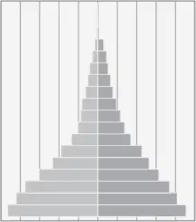
Use the graph below to answer the following question: Chad would be classified as a -
developed country
newly Industrialized country
less developed country
wealthy country
Which of the following countries has the largest percentage of Hindus?
China
Saudi Arabia
India
Pakistan

Which of the following BEST fits into the Center Box?
Effects of Hinduism on South Asia
Effects of the colonization of South Asia
Effects of the overpopulation of South Asia
Effects of Monsoons on South Asia

Which of the following BEST fits into Box #4?
Spread of Hinduism
Increase in amount of Brain Drain
Pollution of the Ganges River
Economic Development of India
Islam is to ________ as Hinduism is to ________.
Pakistan; India
India; Pakistan
Nepal; Pakistan
Pakistan; Nepal

After gaining independence, the region shown by letter "B" became an independent country known as ___________?
Kashmir
Bangladesh
Pakistan
Sri Lanka
The transfer of jobs to other countries to save on labor costs is...
Comparative Advantage
Migration
Outsourcing
Urbanization
Which of the following is a push factor for migration in India?
US outsourcing to India
Availability of jobs in urban areas
Good education in urban areas
Political instability
The division of India after the British left South Asia is known as...
separation of powers
Industrial Revolution
colonization
The Partition
After WWII South Korea was occupied by which country?
Japan
China
United States
Soviet Union
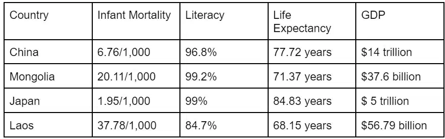
Which country has the highest standard of living?
China
Mongolia
Japan
Laos

Which country has the lowest standard of living?
China
Mongolia
Japan
Laos
What are the dates of the Korean War?
1950 - 1953
1939 - 1945
1914 - 1918
1861 - 1865
Which of the following is an accurate description of the landscape of North Korea?
Very mountainous
Flat grasslands
Mostly desert
All of the above
The religious affiliations of many of the people living in Southeast Asia include –
Islam and Hinduism
Buddhism and Islam
Judaism and Hinduism
Animism and local religions

Which country is labeled as A?
North Korea
Mongolia
China
Japan
South Korea
Which country is labeled as B?
North Korea
Mongolia
China
Japan
South Korea
Which country is labeled as C?
North Korea
Mongolia
China
Japan
South Korea
Which country is labeled as D?
North Korea
Mongolia
China
Japan
South Korea
Which country is labeled as E?
North Korea
Mongolia
China
Japan
South Korea
What is the major reason for the differences in economic prosperity in various areas of the world today?
An unequal distribution of resources
The success of nationalist movements
Religious unity between nations
Membership in the United Nations

Based on the excerpt above, which factor has a major influence on the unique character of Australian society?
Colonization
Multiculturalism
Physical geography
Indigenous traditions

According to the excerpt above, building a highway across the outback in Australia would impact the area by—
altering the climate conditions in the region
increasing the economic opportunities in the area
endangering the indigenous people living in the area
threatening the lives of rare animals that inhabit the region
The geographic isolation of a people frequently reinforces
a traditional way of life
the development of scientific investigation
the need for higher education
a process of cultural diffusion
The culture of Oceania is a blend of-
European and Indigenous
European, Asian, and Indigenous
Mexican, Australian, and American
Mexican and American

Above are the flags of three countries in Oceania. What can be concluded about the history of these countries?
They have a history of Asian colonization
They have a history of European colonization
They have a history of American colonization
They have a history of Latin colonization
What is the climate of most of Oceania?
Tropical wet
Mediterranean
Subarctic
Humid subtropical
32.8810° N, 97.1550° W are the GPS coordinates of Colleyville, Texas. This represents which of the 5 Themes of Geography?
Absolute location
Relative location
Human Environment Interaction (HEI)
Movement
Which of the following are not part of the 5 Themes of Geography?
Place
Region
Movement
Desertification
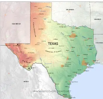
Identify the type of map above.
Physical
Political
Thematic
Governmental

