
 Worksheets
EOY CP3 review
Total questions: 37
Worksheet time: 24mins
The average number of people living in an area.
population density
population zone
polder
peninsula

What vast area is between the Urals and Pacific Ocean?
Vladivostok
Siberia
Kazan
Moscow
The Alps are a mountain range and a major ________ destination.
tourist
business
avalanche
research
The European Plain is a successful _________ area.
mining
logging
agricultural
Most of Europe is farther ___________ than the U.S.
South
East
North
West
Which of the following is NOT a major land region of Europe?
Gulf Coast
Central Uplands
Alpine Mountain System (Alps)
North European Plain
The North European Plain has the most productive farmland.
True
False
True or False: Siberia has long, hot summers.
True
False
The largest climate region of Russia is ______.
Marine West Coast
Subarctic
Tundra
Humid Continental
Europe is a large _________ made up of smaller __________.
Island(s)
Peninsula(s)
Mountain Range(s)
A major factor that affects climate in Europe is _____.
Elevation
Nearness to water
Plateaus
Rivers
Both Europe and Russia have a great deal of ______.
Iron ore
Timber/Forests
Hydroelectricity
Fossil Fuels
In Russia the grasslands are known as ______.
Prairies
Steppes
Tundra
Permafrost
Which of the following is NOT a reason that Russia has difficulty developing its natural resources?
huge size
harsh climate
frozen rivers and ports
small population
How many time zones are there?
20
12
24
36

Which region in Latin America is known for its dense rainforest and diverse wildlife?
Amazon Rainforest
Patagonia
Andes Mountains
Pampas

What is the name of the longest mountain range in Latin America?
Andes
Alps
Rockies
Himalayas

Which body of water lies to the east of Latin America and is known for its turquoise blue color?
Caribbean Sea
Indian Ocean
Red Sea
Mediterranean Sea

Which body of water lies to the north of Latin America and is known for its oil reserves?
Caribbean Sea
Gulf of Mexico
Pacific Ocean
Atlantic Ocean

Which country in Latin America is famous for its ancient ruins of Machu Picchu?
Brazil
Peru
Mexico
Argentina

What is the approximate size of the Amazon Rainforest?
5.5 million square kilometers
100 million square kilometers
10 million square kilometers
1 million square kilometers

Which country in Latin America is home to the Atacama Desert, one of the driest places on earth?
Peru
Chile
Argentina
Brazil

Which Latin American country is an island nation in the Caribbean Sea?
Guatemala
Haiti
El Salvador
Nicaragua
Which country in Latin America has the largest coastline along the Gulf of Mexico?
Argentina
Brazil
Mexico
Cuba

What is the capital city of Peru?
Bogota
Buenos Aires
Santiago
Lima
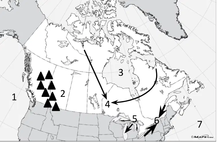
Which is marked with a "1" on the map?
Hudson Bay
Pacific Ocean
Lake Superior
Atlantic Ocean
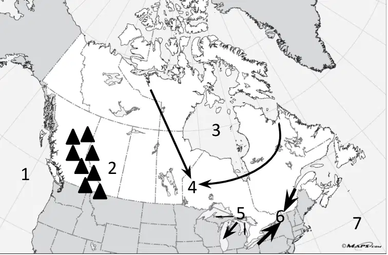
Which physical feature would be at the number "2" on the map?
Lake Huron
Canadian Shield
Rocky Mountains
St. Lawrence River
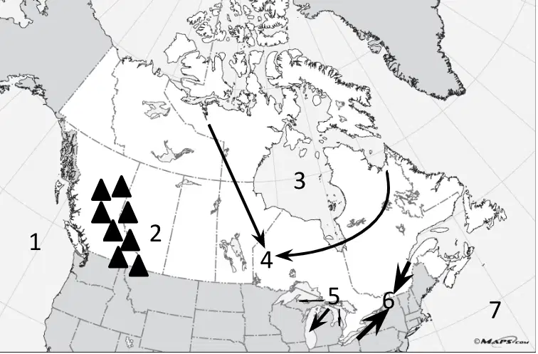
Which number would be closest to the St. Lawrence River/Seaway?
4
5
6
7
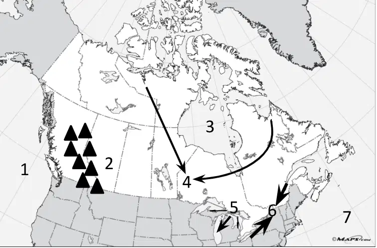
Which physical feature, which surrounds the Hudson Bay, would be found near the number '4' on the map?
Rocky Mountains
Atlantic Ocean
Canadian Shield
Pacific Ocean
Where are the territories found in Canada?
Northern Canada
Southern Canada
What is the capital of Canada?
Quebec
Ottawa
Atlanta
Ontario
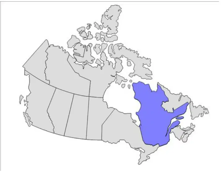
Which province does the shaded area represent?
Quebec
Ontario
Saskatchewan
Manitoba
How does climate impact where people live?
Most people live in the southern part of Canada because it's warmer there.
Most people live in the northern part of Canada because its milder.
Most people live in the territories due to the abundant sunshine.
Most people live in the territories due to permafrost.
How does Canada's location impact trade?
Canada uses mostly air travel to trade.
Canada uses mostly cars to trade with Europe.
Canada uses the Arctic Ocean for trade.
Canada uses its border with the United States to trade.
How do natural resources impact trade in Canada?
Canada uses their southern land for farming due to the long growing season.
Canada uses their mountains to create hydroelectric power.
Canada uses their permafrost to create a large ice market.
Canada uses their rivers to create solar power.

