Worksheets
2007 SOL RELEASED TEST
Total questions: 67
Worksheet time: 34mins
How have rainforests and mountains affected Latin America's economic growth?
encouraging the exchange of cultural ideas
preventing the establishment of colonial empires
limiting the development of transportation systems
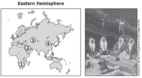
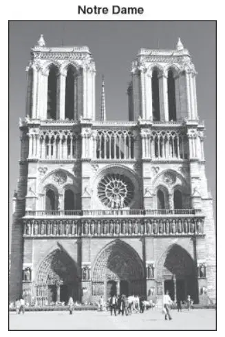
In which region was this photograph most likely taken?
1
2
4
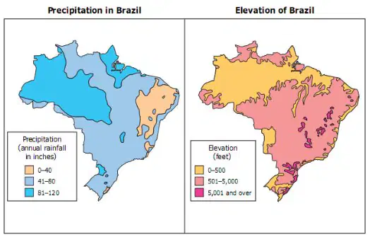
Brazil experiences the greatest amount of rainfall at an elevation that is —
at 6,560 feet
at 1,640 feet
lower than 490 feet
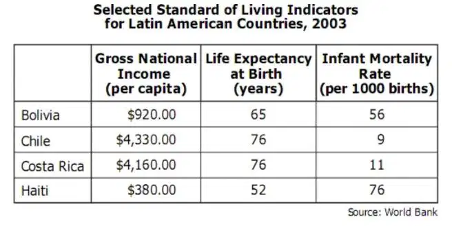
Which country is likely to have the highest emigration rate due to push factors?
Costa Rica
Haiti
Bolivia
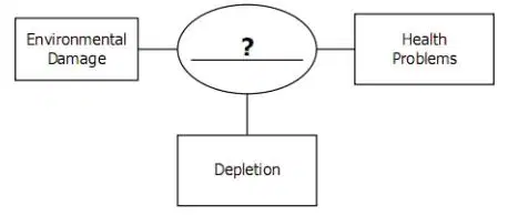
Which title best completes the diagram?
Demand Created by Technology
Cultural Influences on Production
Costs of Resource Use
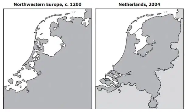
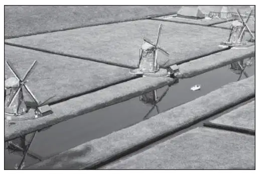
Construction of polder land
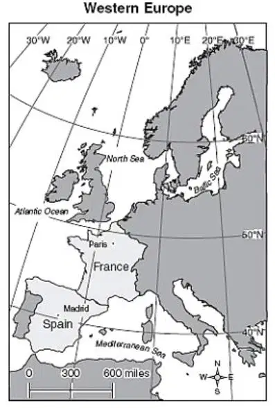
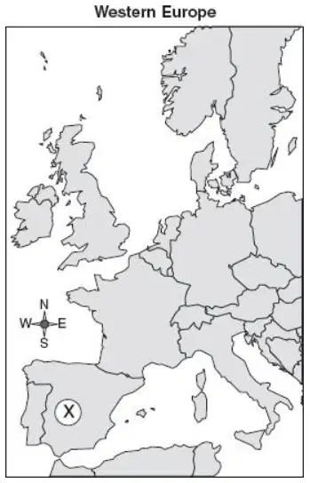
What is the distance from Paris to Madrid?
550 miles
650 miles
350 miles
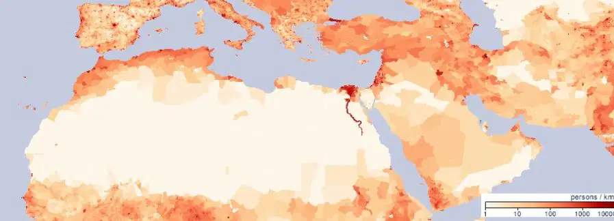
Which best explains the population distribution of North Africa?
Settlements are found in areas with reliable sources of water.
Mineral deposits have led to the creation of urban centers.
The economy of the region encourages widespread small communities.

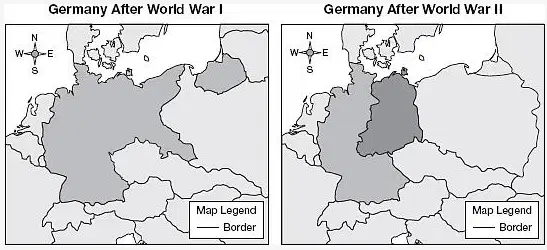
After World War II, Germany was —
expanded into a larger country
divided into two countries
controlled by Austria
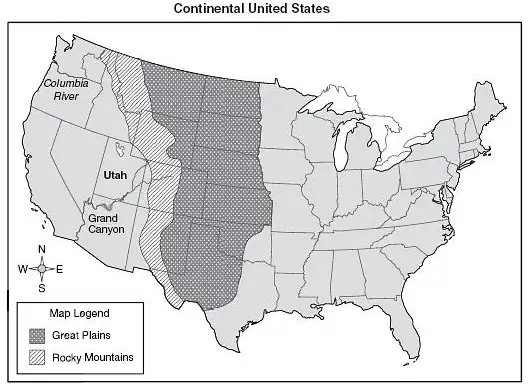
Utah is located —
north of the Columbia River
south of the Grand Canyon
west of the Rocky Mountains
The negative impact of using coal and oil is —
political
cultural
environmental
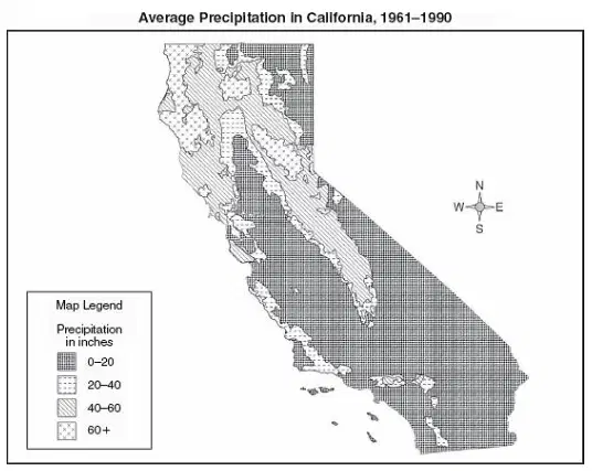
This map of precipitation would be most useful to a —
manufacturer
farmer
lawyer
Which countries share a common language?
Italy and Cambodia
Portugal and Brazil
Germany and Egypt
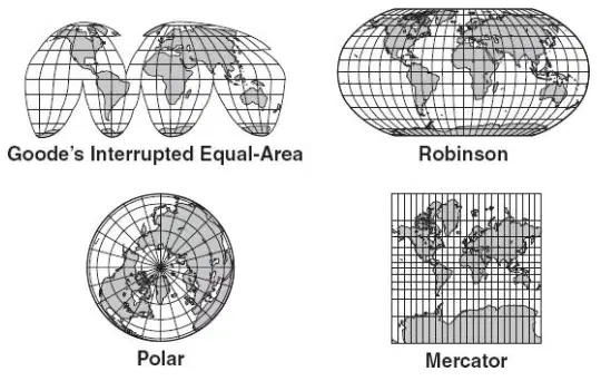
How many of these map projections show the Southern Hemisphere?
Two
Three
One

Which push factor caused people to flee Bosnia in the early 1990s?
Lack of job opportunities
Religious persecution
Overpopulation
Geographers use pictures taken by remote sensing devices for all EXCEPT —
calculating death rates
studying traffic patterns
forecasting weather
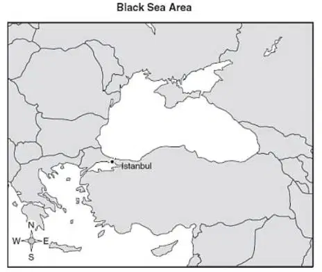
Istanbul’s location contributed to its importance by allowing the city to control the —
plains
oceans
straits between the Black Sea and Aegean Sea
The introduction of high-yield rice and wheat in South Asia is called the —
green revolution
green market
greenbelt movement
Seismic monitoring helps minimize the impact of which natural hazard?
Earthquakes
Floods
Tornadoes
Damage has been caused to trees, plants, fish, and buildings by pollutants from factories. This type of pollution is called —
mercury poisoning
the ozone layer
acid rain
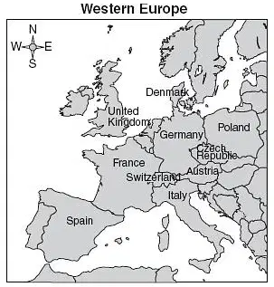
Which languages are most likely spoken by a majority of the people of Switzerland?
English, Italian, and Spanish
French, German, and Italian
Danish, German, and Polish
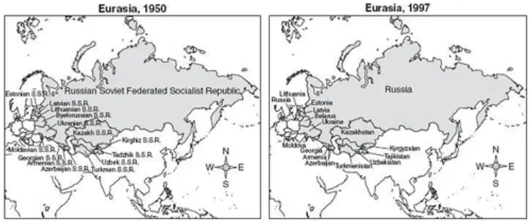
The most likely reason for the differences in the two maps is —
the collapse of the Soviet Union
successful attempts by Russia to crush nationalist movements
expanded military control in the old Soviet Union
The uneven distribution of natural resources on Earth is balanced through —
population distribution
world trade
bartering
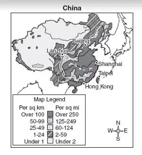
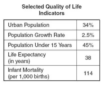
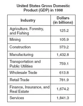
Which country is most likely represented by the information in the table?
Australia
Ethiopia
France
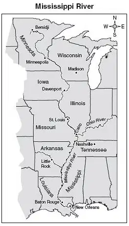
The source of the Mississippi River is closest to —
Cairo, Illinois
St. Louis, Missouri
Bemidji, Minnesota
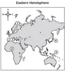
Which region is undergoing desertification?
4
3
2
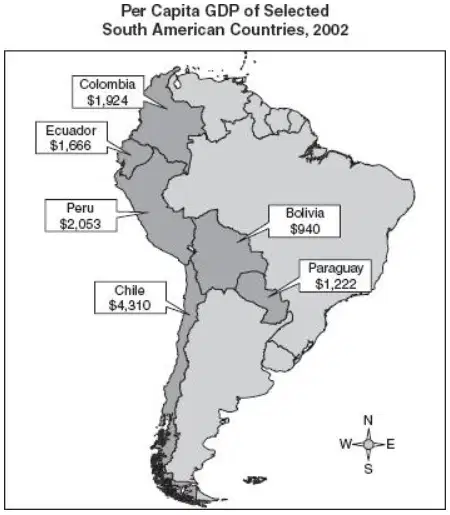
Which statement about economic activity is correct?
Landlocked countries have limited access to trade routes.
Coastal countries have limited access to natural resources.
These countries have similar access to modern technologies.
Pittsburgh owes its growth to the —
steel industry
computer industry
aircraft industry
Money is a —
capital resource
natural resource
nonrenewable resource
In the United States, no new nuclear power generators have been constructed since 1996 because of —
opposition from coal miners
discovery of vast oil deposits
concerns over safety

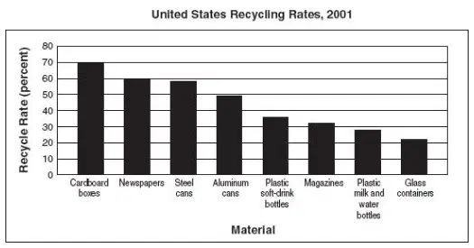
Which materials are most commonly recycled?
Plastics
Glass
Wood based products
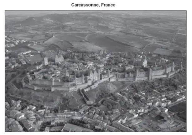
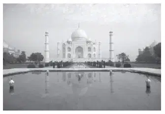
Based on the photograph, this city was designed to serve as a center for —
religion
security
trade

The Brazilian government is struggling to preserve what type of ecosystem?
Savannas
Rain forests
Wetlands
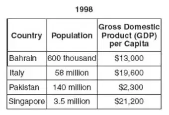
Which country is most likely to be the source of many immigrants to work in the UAE?
Pakistan
Italy
Bahrain
Which factor has slowed India’s economic development and prevented improvement in the people’s standard of living?
An aging population
A rapid population growth rate
Plentiful natural resources
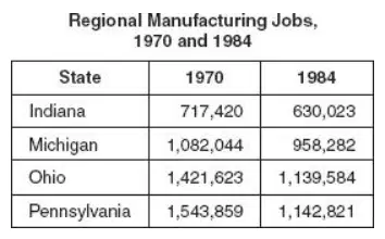
What name has been given to this declining manufacturing region?
Wheat Belt
Cotton Belt
Rust Belt

The EU was formed primarily to provide —
political power to rival the United States
economic cooperation between members
emergency assistance for sub-Saharan countries
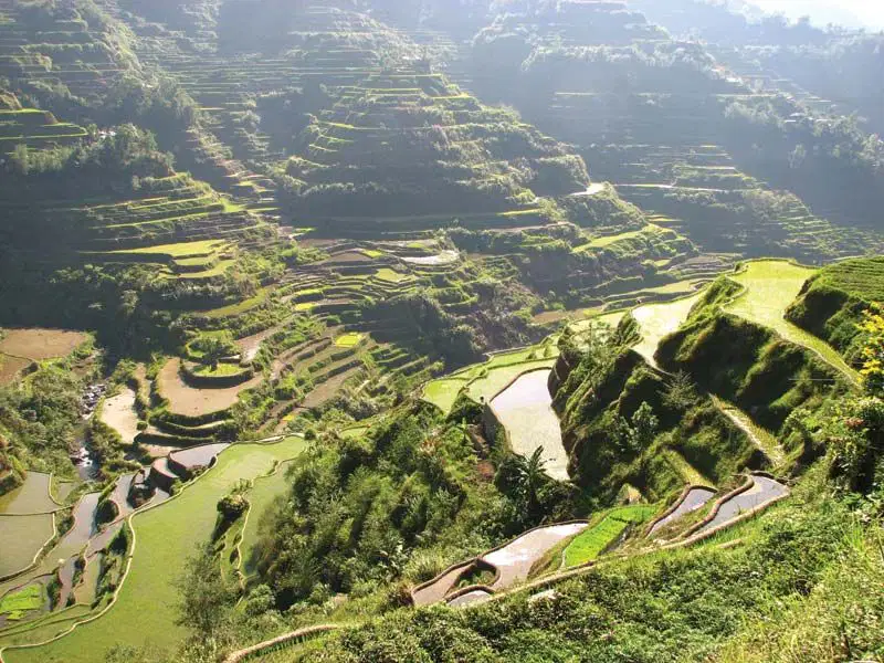
Farmers in Southeast Asia have adapted mountainous areas for agriculture by —
constructing terraces
practicing crop rotation
building levees
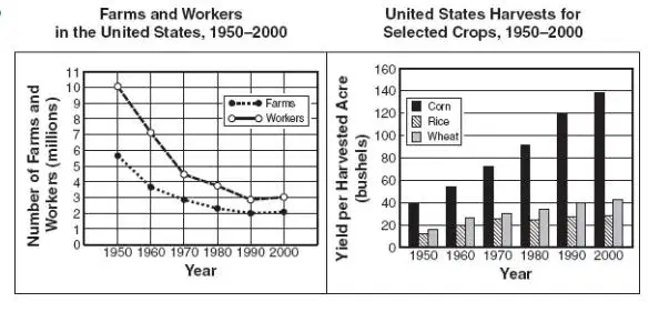
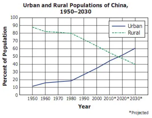
What most likely caused the trends in these graphs?
Increased agricultural imports
Improved transportation systems
Advanced agricultural technologies

The ancient Incan city in the Andes Mountains of Peru is —
Machu Picchu
Teotihuacan
ChichÉn ItzÁ
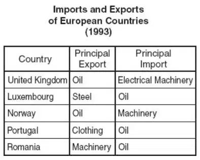
Why are Romania and Norway effective trading partners?
They specialize in goods each other needs.
They are not effective trading partners.
They specialize in the same type of industries.
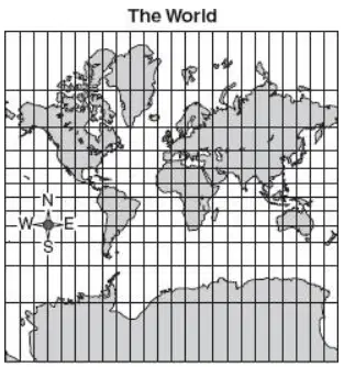
high latitudes (Polar areas)
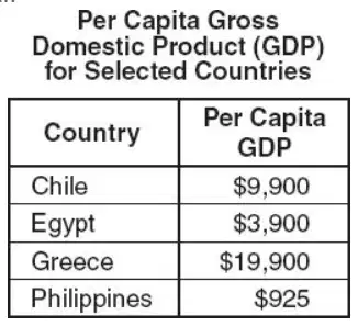
Which country benefits most from a major economic alliance with the United States (NAFTA)?