
NEW
Font size
 Worksheets
Ancient India PPT Quiz
Total questions: 60
Worksheet time: 30mins
What time period does the study of Ancient India cover?
a) 3000-1000 BCE
b) 2500-400 BCE
c) 1500-500 BCE
d) 2000-300 BCE
Which river is considered sacred in India and is one of the longest rivers in the country?
Amazon River
Nile River
Ganges River
Mississippi River
Which mountain range forms the northern boundary of the Indian subcontinent?
Andes Mountains
Rocky Mountains
Himalayan Mountains
Alps Mountains
Which ocean is located to the south of India?
Atlantic Ocean
Pacific Ocean
Arctic Ocean
Indian Ocean
Which river was central to the development of the Harappan civilization?
Amazon River
Indus River
Yangtze River
Danube River
What seasonal winds bring heavy rains to the Indian subcontinent?
Trade winds
Westerlies
Monsoon winds
Polar easterlies
What term is used to describe the large landmass that includes India, Pakistan, and Bangladesh?
Subcontinent of Africa
Subcontinent of Europe
Subcontinent of India
Subcontinent of Australia
Which ancient civilization developed along the Indus River?
Egyptian civilization
Mesopotamian civilization
Harappan civilization
Mayan civilization
Which of the following is a geographical feature of ancient India?
Amazon River
Himalayan Mountains
Sahara Desert
Rocky Mountains
What river is associated with the emergence of the Harappan civilization?
Nile River
Amazon River
Indus River
Mississippi River
Which of the following was an achievement of the Harappan civilization?
Building pyramids
Developing a writing system
Arranging roads into a series of grid-systems
Creating a calendar
What type of architecture was used by the Harappan civilization?
Wooden houses
Stone castles
Brick buildings
Ice igloos
Which of the following is NOT a geographical feature of ancient India?
Ganges River
Indian Ocean
Monsoon winds
Andes Mountains
What was one of the sanitation achievements of the Harappan civilization?
Public baths
Underground tunnels
Sewer systems
Water wells
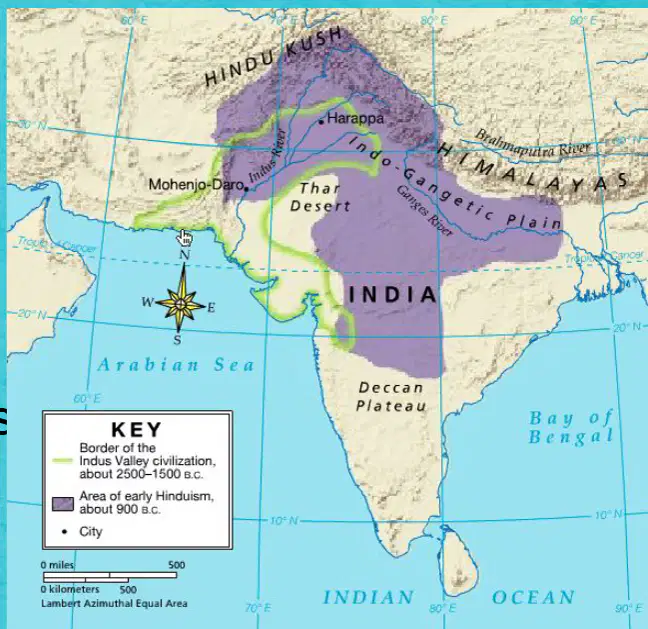
Which sea is located to the west of the Ganges River according to the map?
Arabian Sea
Bay of Bengal
Mediterranean Sea
Red Sea
What is the relative location of the Ganges River in India?
Northern India
Southern India
Western India
Eastern India
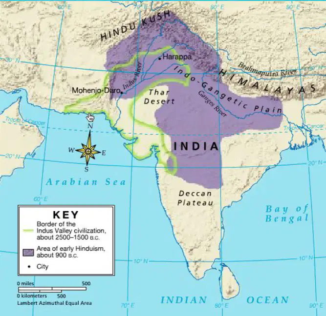
Which of the following is a distinguishing feature that can help identify the relative location of the Himalayan Mountains?
The presence of the Ganges River
The proximity to the Arabian Sea
The location near the Deccan Plateau
The closeness to the Bay of Bengal
Which ocean is located to the south of India?
Atlantic Ocean
Pacific Ocean
Indian Ocean
Arctic Ocean
What is one distinguishing feature that can help you locate the Indian Ocean on a map?
It is located to the west of Africa.
It is located to the south of India.
It is located to the east of Australia.
It is located to the north of Europe.
Which desert is located in the northwestern part of India?
Sahara Desert
Gobi Desert
Thar Desert
Kalahari Desert
Which river is shown flowing through the Indo-Gangetic Plain?
Nile River
Amazon River
Ganges River
Mississippi River
What is the name of the plateau located in southern India?
Deccan Plateau
Tibetan Plateau
Colorado Plateau
Iranian Plateau
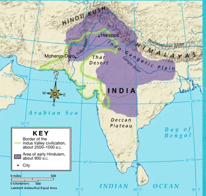
Which desert is located near the Indus River according to the map?
Sahara Desert
Thar Desert
Gobi Desert
Kalahari Desert
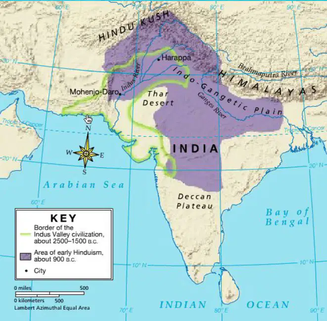
Which mountain range is shown near the Indus River on the map?
Andes
Rockies
Himalayas
Alps
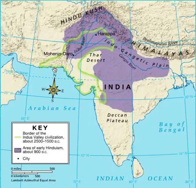
Which sea is located to the south of the Indus River according to the map?
Mediterranean Sea
Red Sea
Arabian Sea
Black Sea
What are the seasonal winds that have blown across South Asia called?
Trade winds
Monsoon winds
Westerlies
Polar easterlies
What effect do summer monsoons have on the Indus River?
They cause the river to dry up.
They cause the river to freeze.
They cause the river to overflow its banks.
They have no effect on the river.
What is deposited across nearby plains due to the overflowing of the Indus River?
Sand
Rocks
Rich silt
Clay
What direction does the winter monsoon blow from?
Northeast
Southwest
Northwest
Southeast
What happens to the moisture in the winter monsoon as it passes over the Himalayas?
It increases
It drops as rain
It stays the same
It evaporates
What is the result of the winter monsoon when it reaches India?
Heavy rain
Dry conditions
Snowfall
Thunderstorms
Where does the summer monsoon come from?
Northeast
Southwest
Northwest
Southeast
What do the summer monsoon winds pick up as they pass over the ocean?
Sand
Moisture
Dust
Heat
What is the result of the summer monsoon in Pakistan and India?
Heavy rain
Dry conditions
Snowfall
Thunderstorms
What is the name of the desert located in the Subcontinent of India?
Thar Desert
Sahara Desert
Gobi Desert
Kalahari Desert
Which mountain range is located to the north of the Subcontinent of India?
Himalayas
Andes
Rockies
Alps
Which sea is located to the west of the Subcontinent of India?
Arabian Sea
Mediterranean Sea
Red Sea
Black Sea
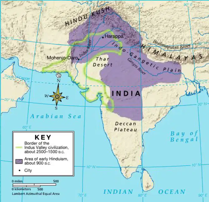
Which mountain range is shown in the map as a major geographical feature of ancient India?
The Rockies
The Himalayas
The Alps
The Andes
What type of architecture did archaeologists find in the city of the Harappan Civilization?
Wooden structures
Stone buildings
Brick architecture
Metal structures
How were the roads arranged in the city of the Harappan Civilization?
In a circular pattern
In a series of grid systems
In a random layout
In a zigzag pattern
What kind of systems did the Harappan Civilization have for sanitation?
Open drains
Sanitation and sewer systems
Natural water bodies
None of the above
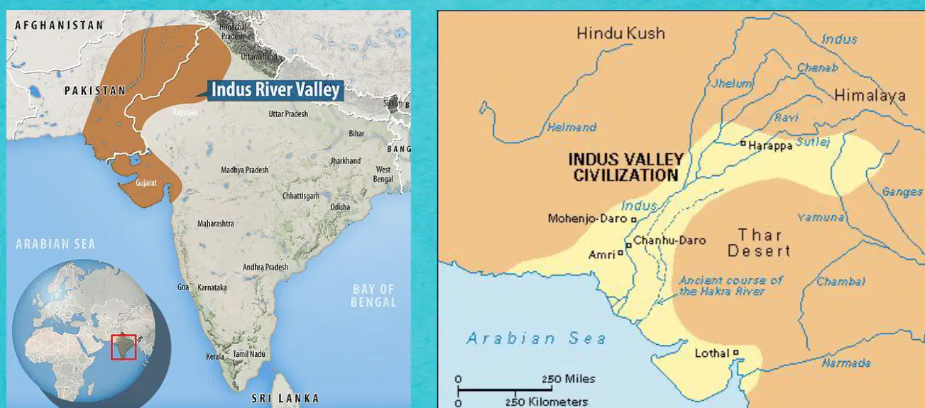
Which ancient civilization is depicted in the provided maps?
Mesopotamian Civilization
Egyptian Civilization
Harappan Civilization
Chinese Civilization
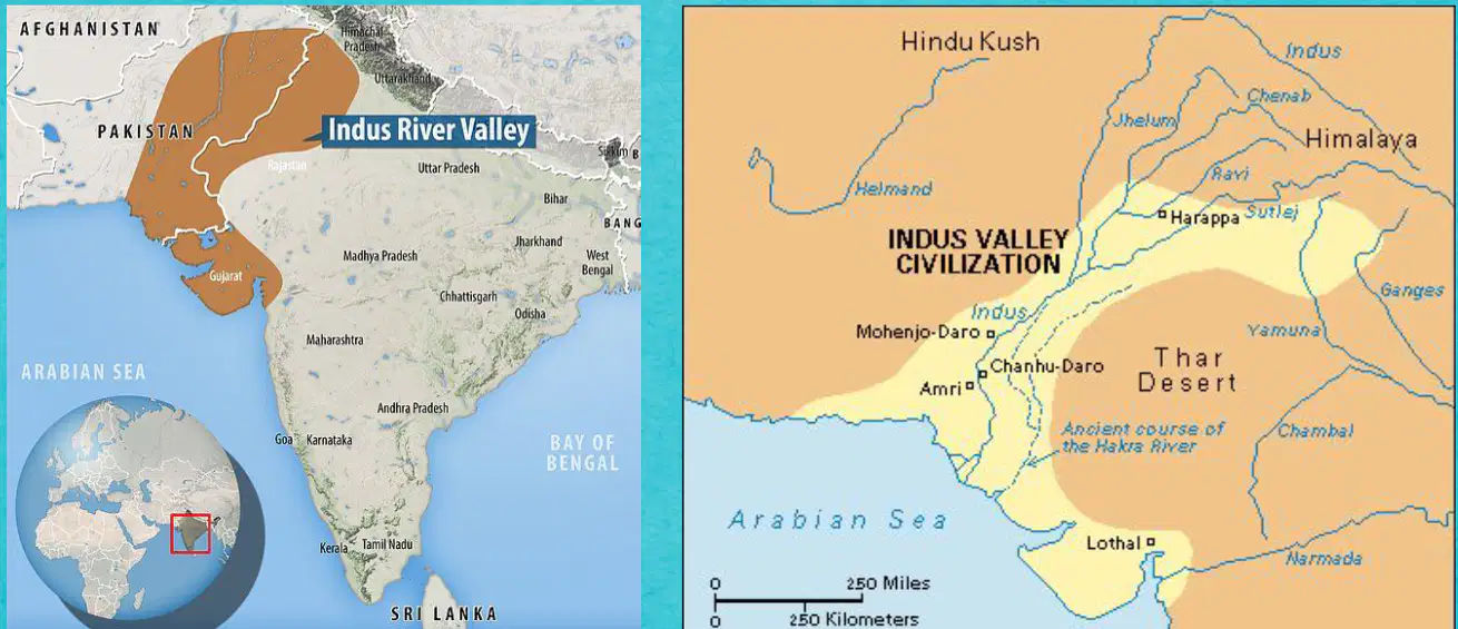
Which river valley is highlighted in the maps?
Nile River Valley
Tigris-Euphrates River Valley
Yellow River Valley
Indus River Valley

Which modern-day countries are part of the region shown in the maps?
India and China
Pakistan and Afghanistan
India and Pakistan
India and Bangladesh
How did the Harappan civilization advance architecture?
It created the first ziggurats.
It created the first brick buildings.
It created the first canals.
It created the first pyramids.
Why is the Harappan civilization significant to Indian history?
It allowed Buddhism to spread outside of India.
It prevented international trade in India.
It was the first permanent agricultural civilization in India.
It was the first monotheistic civilization in India.
How are the Ganges River and Indus River similar?
They both flow into the Atlantic Ocean.
They both flow out of the Zagros Mountains.
They are both located in Egypt.
They are both located in India.
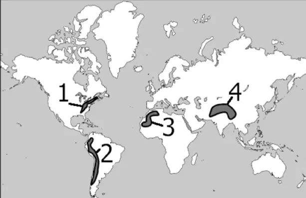
Which number correctly identifies the Himalaya Mountains?
1
2
3
4
Which religion is associated with the concept of dharma, karma, and reincarnation?
Christianity
Islam
Hinduism
Judaism
What are the sacred texts of Hinduism called?
Bible
Quran
Torah
The Vedas
What is the ultimate goal of liberation from the cycle of rebirth in Hinduism?
Nirvana
Moksha
Heaven
Enlightenment
Which religion was founded by Siddhartha Gautama?
Christianity
Islam
Buddhism
Hinduism
What is the name of the Buddhist scriptures?
Bible
Quran
Tripitaka
Torah
Which of the following is NOT a part of the Four Noble Truths in Buddhism?
Suffering exists
Suffering has a cause
Suffering can be ended
Suffering is eternal
What is the Eightfold Path in Buddhism aimed at achieving?
Wealth
Power
Nirvana
Reincarnation
Who is considered the key person in the origins of Buddhism?
Siddhartha Gautama (Buddha)
Aryan Traditions
The Vedas
Moksha
What are the sacred texts of Hinduism?
The Vedas
Tripitaka
Four Noble Truths
Eightfold Path
Which of the following is a basic belief in Hinduism?
Dharma
Nirvana
Eightfold Path
Four Noble Truths
What is the sacred text of Buddhism?
Tripitaka
The Vedas
Dharma
Karma
Which of the following is NOT a basic belief in Buddhism?
Reincarnation
Four Noble Truths
Eightfold Path
Nirvana

