
 Worksheets
Physical Geography Test
Total questions: 37
Worksheet time: 20mins
Name
Class
Date
1.
What are the names of the two tropics we've talked about in class?
(a)
2.
Explain the difference between weather and climate.
4 lines
3.
What does the Mercator projection map fail to represent correctly?
(a)
4.
a narrow strip of land with sea on either side forming a link between two larger areas of land
a)
isthmus
b)
peninsula
c)
strait
d)
plateau
e)
aquifer
5.
a piece of land with water on three sides
a)
peninsula
b)
strait
c)
isthmus
d)
plateau
e)
aquifer
6.
flatland with higher elevation than a plain
a)
plateau
b)
peninsula
c)
strait
d)
isthmus
e)
aquifer
7.
the study of earth and all of its variety
a)
geography
b)
peninsula
c)
strait
d)
isthmus
e)
plateau
8.
narrow body of water between two pieces of land, connecting two larger bodies of water
a)
strait
b)
peninsula
c)
isthmus
d)
plateau
e)
aquifer
9.
natural surroundings
a)
environment
b)
peninsula
c)
strait
d)
isthmus
e)
plateau
10.
individual natural features of the earth's surface
a)
landform
b)
peninsula
c)
strait
d)
isthmus
e)
plateau
11.
When it is winter in the Northern Hemisphere, it is summer in the _____________.
a)
Tropic of Cancer
b)
North Pole
c)
Southern Hemisphere
d)
galaxy
12.
Off each coast of a continent lies a plateau called a(n)
a)
island
b)
isthmus
c)
continental shelf
d)
trench
13.
Plains and mountains are examples of:
a)
landforms
b)
hills
c)
plateaus
d)
islands
14.
About 71% of the earth's surface is _________.
a)
continents
b)
islands
c)
water
d)
gases
15.
The movement of the earth's huge landmasses is known as _________.
a)
earthquake activity
b)
continental collision
c)
erosion
d)
continental drift
16.
What is the deepest and largest ocean?
a)
Indian Ocean
b)
Arctic Ocean
c)
Atlantic Ocean
d)
Pacific Ocean
17.
Most of earth's freshwater is found in:
a)
rivers and lakes
b)
glaciers and ice caps
c)
seas and oceans
d)
groundwater
18.
Most of the earth's saltwater is found in:
a)
the water cycle
b)
groundwater
c)
oceans
d)
aquifers
19.
The seven continents could all fit into which ocean?
a)
Pacific
b)
Indian
c)
Atlantic
d)
Mediterranean
20.
Which is the opposite location of a specific place on Earth called?
a)
coordinates
b)
pole
c)
antipode
d)
latitude
21.
The process in which a globe is translated into a flat map is called what?
a)
navigation
b)
projection
c)
mercator
d)
drawing
22.

Using the above image: What was the name of the single large landmass that existed 200 million years ago?
a)
Eurasia
b)
Pangaea
c)
Antarctica
d)
India
23.

Using the above image: Which landmass was NOT connected to another landmass 65 million years ago?
a)
Eurasia
b)
America
c)
India
d)
Australia
24.

Using the above image: What is the approximate latitude and longitude of Kiev?
a)
48 degrees N, 3 degrees E
b)
41 degrees N, 5 degrees E
c)
51 degrees N, 31 degrees E
d)
60 degrees N, 11 degree E
25.

Using the above image: What city is located at approximately 52 degrees N, 1 degree W
a)
Dublin
b)
Rome
c)
Paris
d)
London
26.
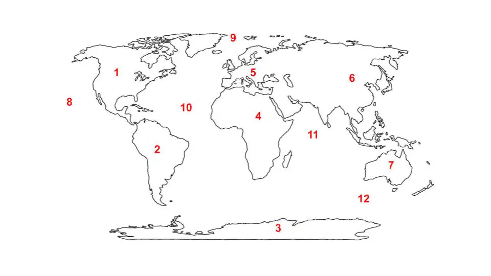
Africa
a)
4
b)
1
c)
2
d)
3
e)
5
27.
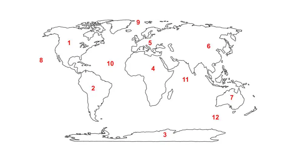
Antarctica
a)
3
b)
1
c)
2
d)
4
e)
5
28.
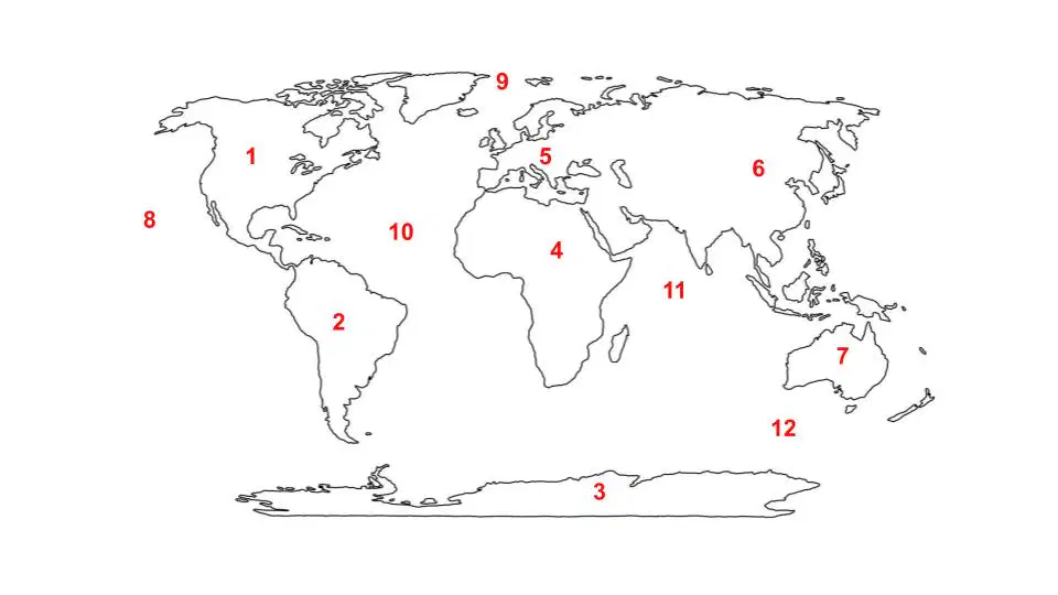
Asia
a)
6
b)
1
c)
2
d)
3
e)
4
29.
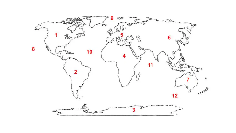
Australia
a)
7
b)
1
c)
2
d)
3
e)
4
30.
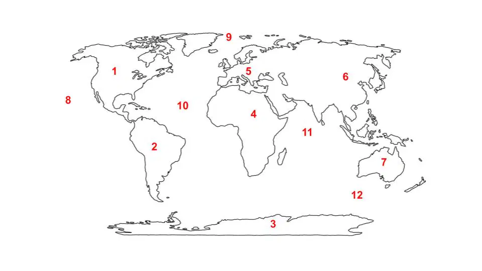
Europe
a)
5
b)
1
c)
2
d)
3
e)
4
31.
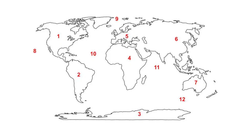
North America
a)
1
b)
2
c)
3
d)
4
e)
5
32.
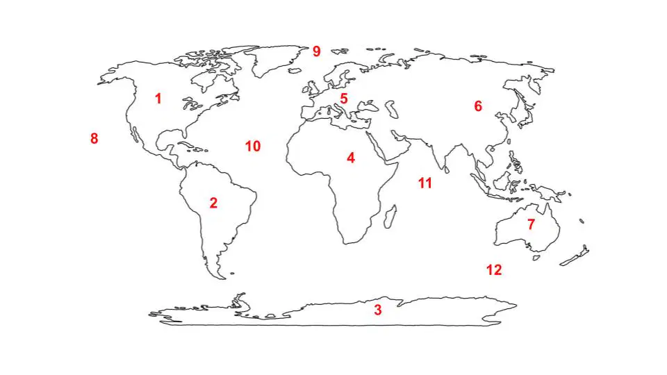
South America
a)
2
b)
1
c)
3
d)
4
e)
5
33.
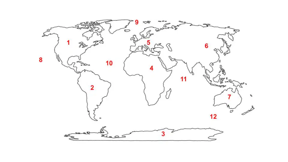
Atlantic Ocean
a)
8
b)
9
c)
10
d)
11
e)
12
34.
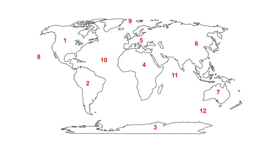
Arctic Ocean
a)
8
b)
9
c)
10
d)
11
e)
12
35.
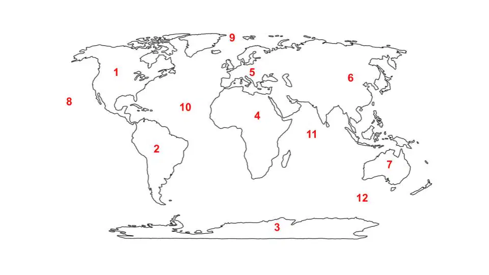
Indian Ocean
a)
8
b)
9
c)
10
d)
11
e)
12
36.
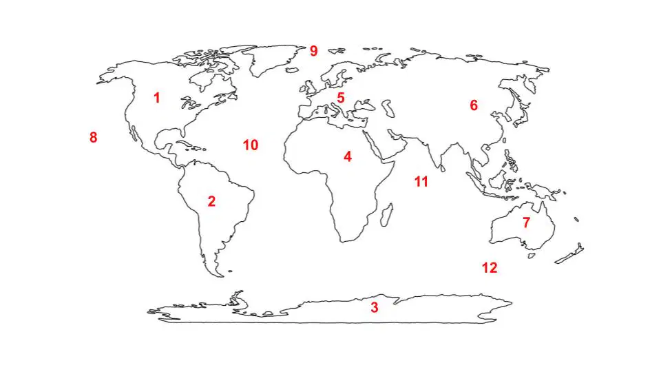
Pacific Ocean
a)
8
b)
9
c)
10
d)
11
e)
12
37.
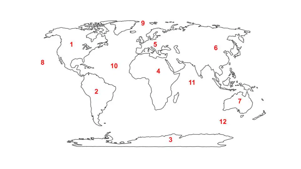
Southern Ocean
a)
8
b)
9
c)
10
d)
11
e)
12
100 %

