
 Worksheets
2025 World Geography: Unit 10 - Southeast & East Asia
Total questions: 41
Worksheet time: 21mins

Which conclusion about economic development in China, Japan, and Korea is reflected by the data in the graph?
Korea’s economic development has lagged recently.
Korea and Japan are at a similar level of development.
China’s economic development exceeds that of Korea.
Japan is far more developed than either China or Korea.
The eastern portion of China is densely populated, while the west is very sparsely populated. Which of the following geographic feature of western China most accounts for this settlement pattern?
Mountainous terrain
Threat of earthquake
Lack of access to water
Political conflict with Tibet
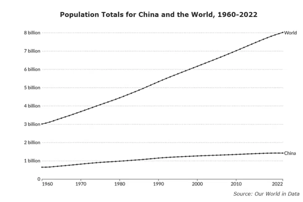
Which conclusion most accurately compares the populations of China and the world?
More than half of the world's population is in China.
China's population is growing at a faster rate than the world.
The world's population is growing at a faster rate than China.
The population of China and the world are growing at a similar rate.
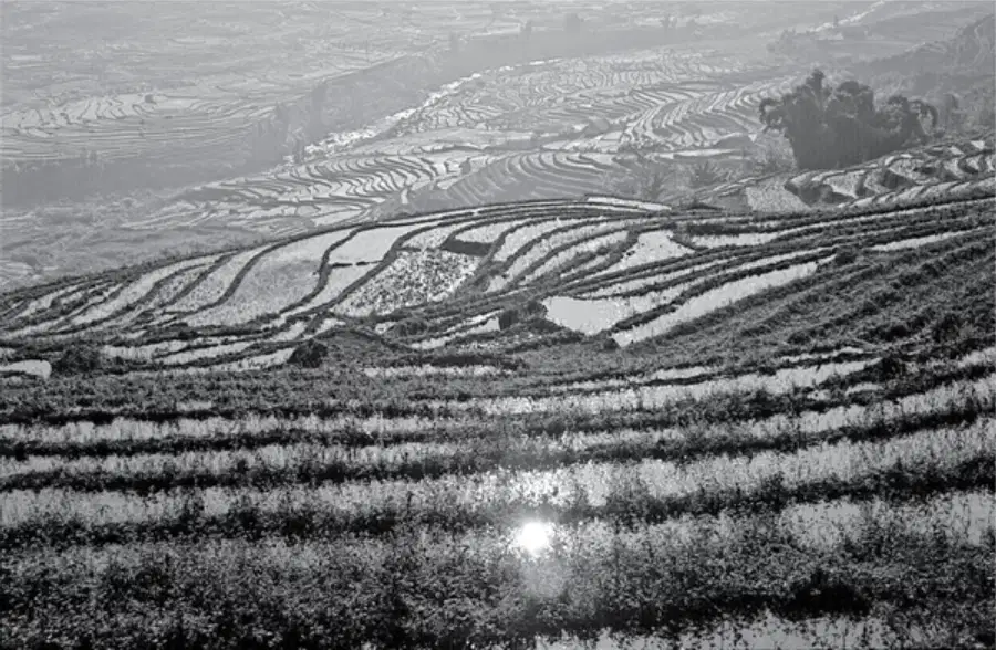
The agricultural practices seen in the photograph are an example of —
globalization
modification of the environment
technological diffusion
cultural convergence
Why has Singapore served as an important location for globalization in the world?
It is a center of agriculture production, exporting rice and wheat to the region.
It is an international port city, connecting trade across the Indian and Pacific oceans
It has the world's busiest airport, providing connections to Australia and the Asian mainland.
It serves as a major center for education, with many people traveling from across Asia to attend its schools and universities.
What is one way the governments of China and the United States operate differently?
In China the electorate only has one party to choose from and in the United States there are multiple political parties.
In China elections are only conducted on the provincial level and in the United States elections are held on the national level.
In China the executive leader is elected by a legislative body and in the United States the executive leader is chosen by popular vote.
In China legislative representatives are chosen from groups of local leaders and in the United States they are chosen from the general population.
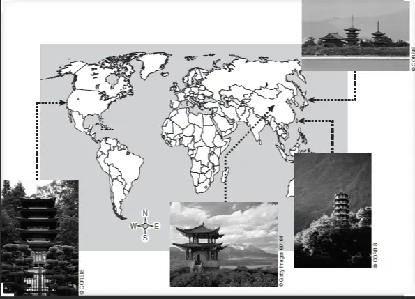
The pagoda is a type of Buddhist architecture.
The pagodas depicted in the photos above illustrate the effects of —
public education
government funding
trade restrictions
cultural diffusion
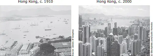
Which of the following most likely caused the change shown in these photographs?
The preservation of local cottage industries
The expansion of international trade
The adoption of a command economy
The extraction of nonrenewable resources from local reserves
Which physical process is most responsible for the formation of islands in the Pacific Ocean?
Erosion
Landslides
Flood deposits
Tectonic activity
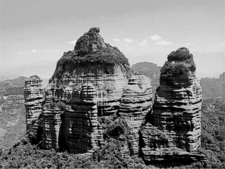
This unique landform of Southeast China is called danxia. The United Nations designated a series of these formations in 2010 as a World Heritage Site. Which physical process is most likely responsible for this landform?
Erosion
Monsoons
Volcanic activity
Tectonic divergence
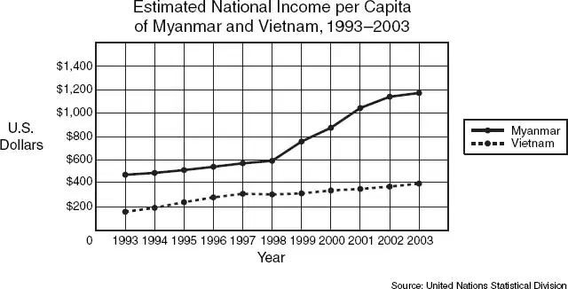
Based on the graph, which of the following conclusions is supported?
The standard of living in Myanmar is greater than that of Vietnam.
Vietnam is a more developed country than Myanmar
Globalization has improved conditions in Vietnam.
Myanmar is shifting to a traditional economy.
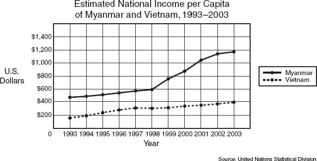
According to the graph, the per capita income —
for Myanmar and Vietnam rapidly declined
in Myanmar increased the most between 1998 and 2002
for both nations remained the same
in Vietnam decreased the most between 1994 and 1997
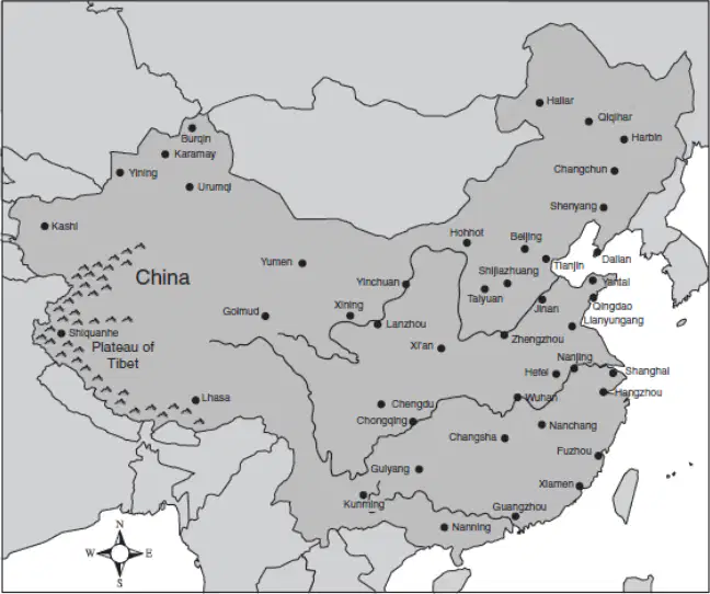
According to the map of China above, which statement most accurately describes the distribution of cities shown above?
The population density is greatest along China’s inland borders.
Urban development is more heavily concentrated in eastern China.
Rice farming is most successful in the mountains of southwestern China.
Extreme temperatures in northeastern China make the region unsuitable for human habitation.
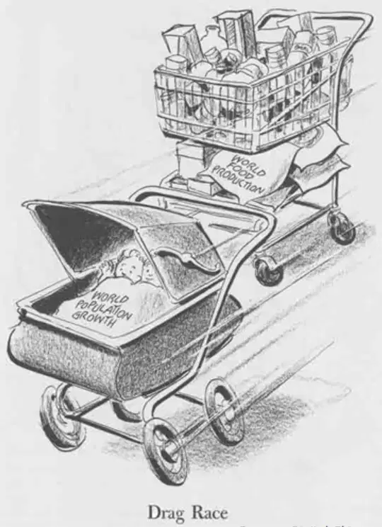
What point of view is expressed in this cartoon?
World food production is exceeding the nutritional demands of the world's population.
World food production is struggling to meet the needs of the world's growing population.
World population estimates are based on the assumption that each family has two children.
World leaders have no control over the pace of world food production.
How does the summer monsoon season benefit the region of Southeast Asia?
It provides plentiful rains for rice fields.
It calms ocean waves to provide for good fishing conditions.
It prevents the approach of typhoons from the Pacific Ocean.
It has strong winds that clear out cloudy skies for months of sunshine.
Which natural disaster is a threat to much of Southeast Asia because of seismic activity occurring in the Indian Ocean?
Tsunamis
Monsoons
Hurricanes
Volcanic eruptions
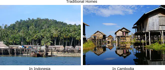
How have the homes pictured above been adapted to the environment of the region?
They are built on stilts to avoid flooding.
They are built from sun-dried bricks.
They are easily mobile to follow traveling animal herds.
They are painted brightly to keep the interiors cool during the heat.
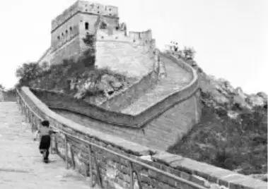
What is the most likely reason the structure illustrated above was built along China’s northern border?
To increase tourism
To control flooding
To provide protection
To increase trade

Based on the information above, why did Chinese rulers modify the physical environment by creating a massive wall across the country?
To keep out enemy invaders
To prevent the annual flooding of Chinese rivers
To provide jobs for Chinese citizens
To encourage foreign trade
North Korea has a communist government with a strong dictator. As a result, it is one of the few economies in the world where the government—
trades exclusively with South Korea
allows individuals the right to property
controls all major aspects of the economy
mixes elements from free-market and command economies
Before Hong Kong was handed over to the Chinese, it was considered to be an example of pure free enterprise. What did this mean?
Trading was freely allowed with the Chinese communists.
Hong Kong was controlled by a committee of capitalists.
The market was primarily controlled by supply and demand.
All production was determined by tourists who shopped there.

Which conclusion can correctly be drawn from this information?
North Korean workers are more productive than South Korean workers.
South Korea has a stronger economy than North Korea.
North Korea has a higher standard of living than South Korea.
South Korea is geographically smaller than North Korea.
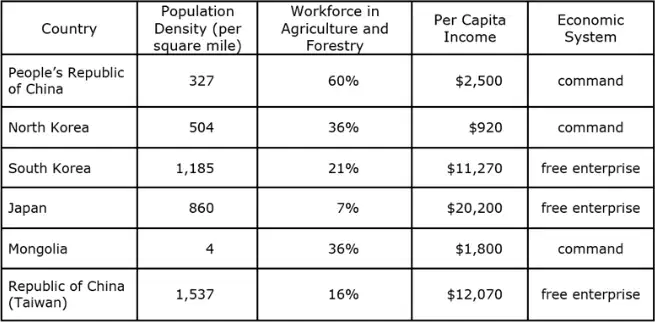
Based on the data provided in the chart, what conclusion can be made about the countries of East Asia?
The countries with the largest percent of their workforce in agriculture and forestry have the highest per capita income.
The countries with free-enterprise economic systems have the highest per capita incomes.
Command-economy countries have the lowest percent of their workforce in agriculture and forestry.
Free-enterprise countries have the lowest population density.
Mongolia is a landlocked country in north central Asia with a harsh climate and few resources. Livestock outnumber people many times over. It can be inferred that Mongolia's economic system is a —
subsistence economy based on farming
subsistence economy based on herding
market economy based on agriculture
market economy based on light industry

Which effect will likely result from the pattern of development shown on the map?
Air quality in China will improve in the coming years.
Taxes will increase in regions where airports are built.
Trade, commerce, and connections across China will increase.
Pressure on the Chinese government to allow democratic participation will increase.
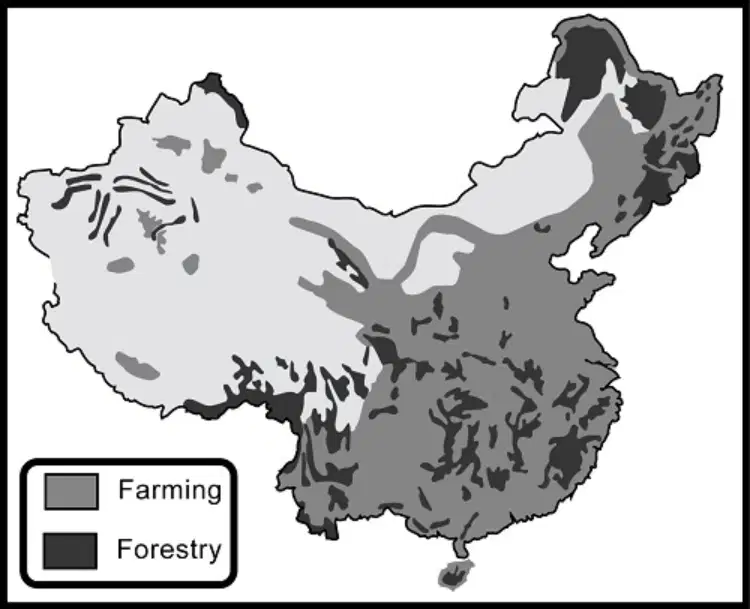
Which factor most affects the pattern of farmland distribution shown on the map above?
Access to seaports for trade
Industrial waste pollution in western China
Dry, rough terrain in large portions of western China
Government planning restricting farm development to the eastern China
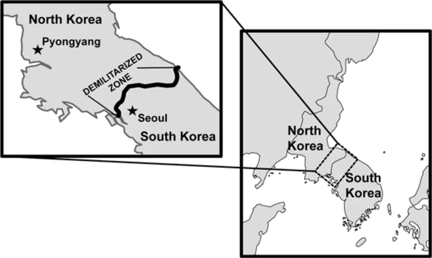
The establishment of the border illustrated on the maps is an example of how borders are created to-
establish countries
divide peninsulas
form free trade zones
follow the course of rivers
The religious affiliations of many of the people living in Southeast Asia include —
Islam and Hinduism
Buddhism and Islam
Judaism and Hinduism
Animism and local religions
Research about the cultures of Southeast Asia would most likely include an examination of —
water resources
language patterns
climate conditions
modern civil wars
Which of the listed characteristics are associated with Buddhism?
Caste System
Four Noble Truths
Reincarnation
Muhammad
Five Pillars
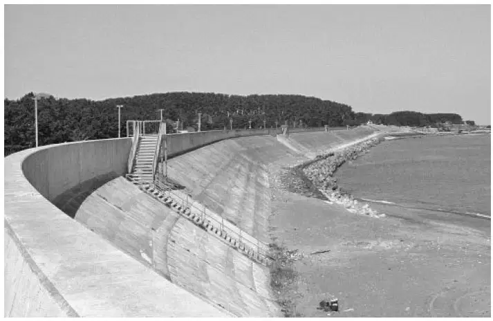
How does the engineering project in the photograph enable Japan to adapt to its environment?
It controls ocean tides for shipping.
It strengthens structures during an earthquake.
It improves Japanese fishing along the coastline.
It helps protect coastal communities from tsunamis.
One way that both China and Japan have modified the environment has been by building infrastructure needed to -
bring water to remote villages
manage pollution created by industry
repair damage done by volcanic activity
supply energy to large, growing populations

What is the country that corresponds to the number 3?
Japan
Taiwan
North Korea
South Korea
What is the country that corresponds to the number 4?
Japan
Taiwan
North Korea
South Korea
What is the country that corresponds to the number 2?
China
Taiwan
North Korea
South Korea
Which of these Asian countries is a city-state?
Singapore
Malaysia
Thailand
Indonesia
Identify a common natural disaster in Japan.
Tornadoes
Earthquakes
Hurricanes
Blizzards
The Silk Road was a historic trade route that connected China with which other region?
Europe
South America
Africa
Australia
Which Asian country is known as the "Land of the Rising Sun"?
China
Japan
South Korea
Thailand
What is the predominant religion in Indonesia?
Buddhism
Christianity
Islam
Hinduism

