
 Worksheets
Oceanography - The Ocean Basin.
Total questions: 41
Worksheet time: 29mins
Name
Class
Date
1.
What is an underwater mountain formed by a volcano?
a)
trench
b)
rift zone
c)
seamount
d)
mid ocean ridge
2.
What is the steep slope at the edge of the continental shelf?
a)
seamount
b)
mid-ocean ridge
c)
continental slope
d)
rift zone
3.
What are underwater mountain ranges called?
a)
continental shelf
b)
mid-ocean ridges
c)
abyssal plains
d)
continental slopes
4.
Where is the shallowest part of the ocean floor?
a)
continental slope
b)
continental shelf
c)
abyssal plains
d)
rift zones
5.
What is the flat land located on either side of the mid-ocean ridge?
a)
continental slope
b)
continental shelf
c)
abyssal plain
d)
ocean basin
6.
What is the deepest part of the ocean basin?
a)
abyssal plains
b)
trenches
c)
rift zones
d)
mid-ocean ridge
7.
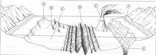
What is letter C?
a)
Mid-Ocean Ridge
b)
Cont. Shelf
c)
Cont. Slope
d)
Abyssal Plain
8.
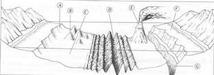
What is letter D?
a)
Cont. Shelf
b)
Mid-Ocean Ridge
c)
Volcanic Island
d)
Seamount
9.
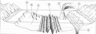
What is letter A?
a)
Cont. Shelf
b)
Cont. Slope
c)
Seamount
d)
Abyssal Plain
10.
Seamount is similiar to...
a)
a volcanic island
b)
a small mountain or volcano
c)
The Great Plains
d)
The Grand Canyon
11.
Rift is similiar to ...
a)
A hole
b)
A divide
c)
A valley
d)
A trench
12.
What is the difference between a volcanic island & a seamount?
a)
A volcanic island rises above the water & a seamount does not
b)
A seamount rises above the water & a volcanic island does not
c)
Both the seamount & volcanic island are underwater
d)
Both the seamount & the volcanic island rise above the water
13.

About how much of the Earth's surface is covered by global oceans?
a)
70 percent
b)
20 percent
c)
90 percent
d)
15 percent
14.
How many basins is the ocean divided into?
a)
7
b)
1
c)
4
d)
5
15.
The ocean floor is as diverse as the surface of the continents.
a)
True
b)
False
16.
The measurement of the ocean depths and the charting of the shape or topography of the ocean floor is called _________________.
a)
oceanography
b)
geography
c)
Bathymetry
17.
What is a small underwater craft used for deep sea research called?
a)
sonar
b)
a satellite
c)
a submersible
18.
What are the names of the ocean basins?
a)
Pacific, Atlantic and Indian
b)
Pacific, Arctic and Antartic
c)
Pacific, Atlantic, Indian and Arctic
d)
Pacific and Atlantic
19.
The study of the shape of the Earth is __________.
a)
topography
b)
biography
c)
tipography
20.
Which ocean basin is the smallest?
a)
Indian Ocean
b)
Atlantic Ocean
c)
Arctic Ocean
21.
Sonar is the most accurate way used to map
a)
the ocean floor
b)
sea level
c)
the moons of Jupiter
d)
the Grand Canyon
22.
This is a shelf that is gently sloped and extends from the shoreline toward the deep-ocean basin.
a)
continental shelf
b)
continental basin
c)
seamount
d)
continental rise
23.
Which feature includes the deepest parts of the ocean
a)
deep sea trench
b)
contintental margin
c)
atoll
d)
rift valley
24.
Large reservoirs of petroleum and natural gas can be found here
a)
continental shelves
b)
mid-ocean trenches
c)
abyssal plains
d)
coastal plains
25.
These plains are the most level places on Earth.
a)
abyssal plains
b)
coastal plains
c)
continental plains
d)
ocean plains
26.
Which condition is NOT needed for growth of coral
a)
cold water
b)
clear water
c)
warm water
d)
sunlight
27.
How many continents are there in the world?
a)
4
b)
5
c)
6
d)
7
28.
How many oceans are there in the world?
a)
7
b)
6
c)
5
d)
4
29.
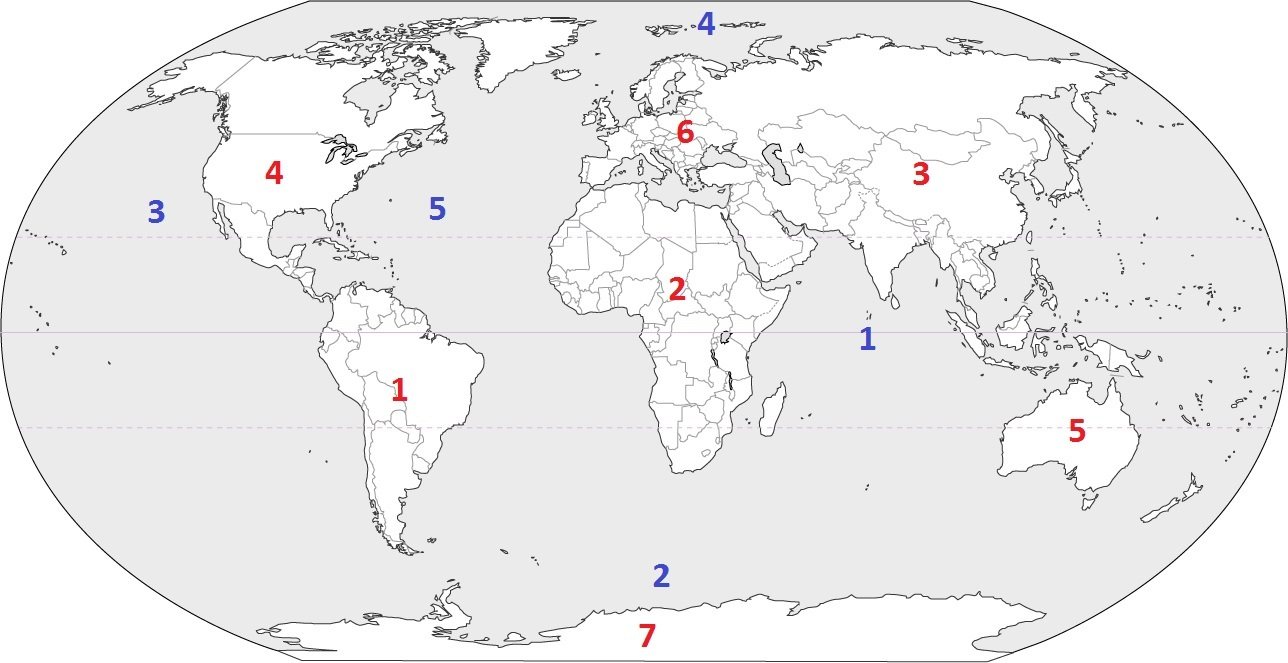
Which continent is located at #3?
a)
Australia
b)
Asia
c)
Europe
d)
South America
30.
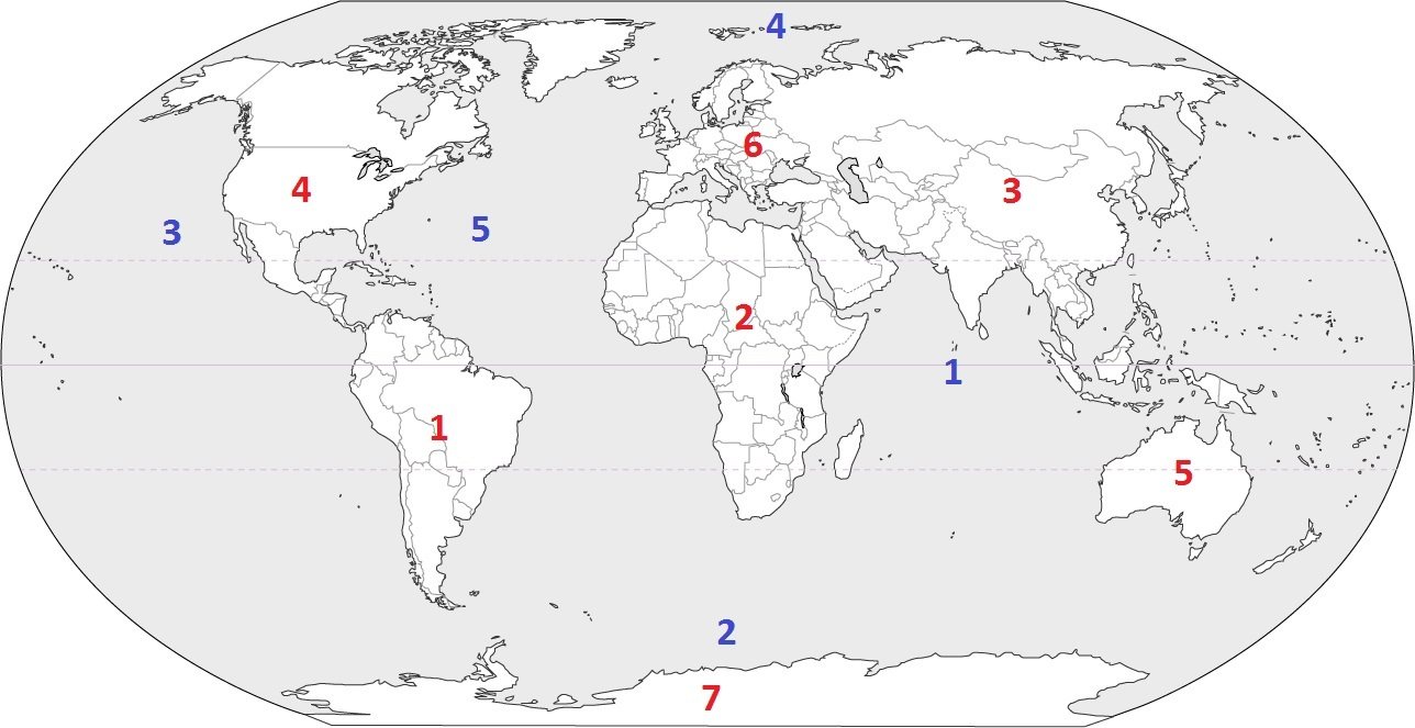
Which continent is located at #5?
a)
South America
b)
Asia
c)
Australia
d)
Antarctica
31.
Bathymetry is...
a)
the measurement of water
b)
the measurement of ocean depths and the charting of the shape of the ocean floor
c)
. The measurement of basin depths and the charting of the shape of the ocean floor (topography)
d)
the measurement of lakes
32.
SONAR
a)
Sound near and ranging
b)
sound navigating rural areas
c)
sound navigation and ranging
d)
Sound ____ ranging
33.
The difference in elevation between the highest and the lowest parts of an area.
a)
sonar
b)
elevation
c)
relief
d)
index contour
34.
Connects points of equal elevation.
a)
topography
b)
contour line
c)
sonar
d)
contour interval
35.
The shape of the land.
a)
continental drift
b)
topography
c)
Pangaea
d)
contour line
36.
Any trace of an ancient organism that has been preserved in rock.
a)
fossil
b)
sonar
c)
continental drift
d)
Pangaea
37.
Continents slowly moving over the Earth's surface.
a)
continental drift
b)
relief
c)
topography
d)
Pangaea
38.
A supercontinent that means "all lands".
a)
continental drift
b)
elevation
c)
relief
d)
Pangaea
39.
A device that bounces sound waves off underwater objects and then records the echoes of these sound waves.
a)
sonar
b)
fossil
c)
topographic map
d)
continental drift
40.
The height above seal level of a point on Earth's surface.
a)
elevation
b)
relief
c)
sonar
d)
topography
41.
The change in elevation from contour line to contour line.
a)
contour interval
b)
index contour
c)
contour line
d)
topography
100 %

