wayground logo

Free Printable Worksheets

NEW

Font size

S
M
L
XL
Worksheets

Earth Science - Measuring Earth: TEST

Total questions: 26

Worksheet time: 7hrs 30mins

Name
Class
Date
1.

How are latitude and longitude lines drawn on a globe of the Earth?

a)

Latitude lines are parallel and longitude lines meet at the Equator.

b)

Longitude lines are parallel and latitude lines meet at the poles.

c)

Latitude lines are parallel and longitude lines meet at the poles.

d)

Longitude lines are parallel and latitude lines meet at the Equator.

2.

To an observer on a ship at sea, at which latitude does the North Star appear closest to the horizon?

a)

20° N

b)

50° N

c)

5° N

d)

85° N

3.

What is the approximate percentage by volume of oxygen present in Earth's atmosphere?

a)

21%

b)

33%

c)

46%

d)

10%

4.

0 degrees latitude is also known as the

a)

Equator

b)

Prime Meridian

c)

International Date Line

d)

Tropic of Capricorn

5.

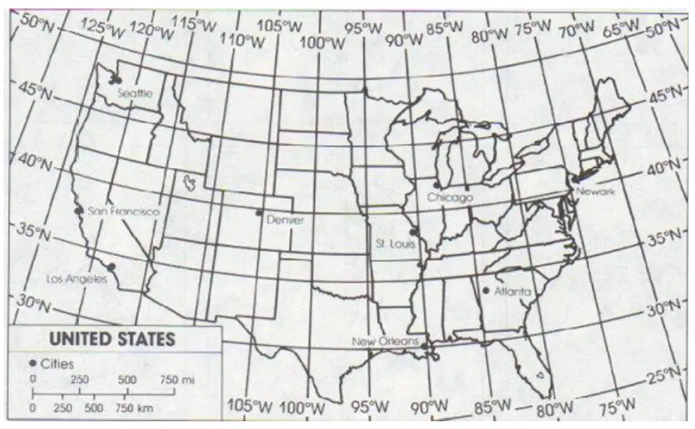
Which city is located closest to 30°N?

a)

Los Angelas

b)

Denver

c)

San Francisco

d)

Chicago

6.
a)
The map shows lines of longitude.
b)
The map shows lines of latitude.
7.
What is the approximate location of letter B?
a)
80oN, 0o
b)
0o, 80oW
c)
80oS, 0o
d)
0o, 80oE
8.
a)
The map show the lines of longitude.
b)
The map shows the lines of latitude.
9.
What is the name of this line at 0 degrees latitude?
a)
Prime Meridian
b)
Equator
c)
North Pole
d)
South Pole
10.

Look at the map. What city is located at 45°N, 75°W?

a)

Brasilia

b)

Ottawa

c)

London

d)

Beijing

11.
What is the correct order (starting from the surface) of Earth's layers?
a)
crust, mantle, inner core, outer core
b)
mantle, outer core, inner core, crust
c)
inner core, outer core, mantle, crust
d)
crust, mantle, outer core, inner core
12.
Earth's inner core is
a)
a layer of hot rock
b)
a solid ball of iron and nickel
c)
a layer of liquid iron and nickel
d)
a layer of rock that forms Earth's outer skin
13.
The crust and the uppermost mantle make up the solid layer of hard rock called the
a)
inner core
b)
asthenosphere
c)
lithosphere
d)
outer core
14.
What layer is shown by letter A?
a)
Crust
b)
Mantle
c)
Outer core
d)
Inner core
15.
What layer is shown by letter B?
a)
Crust
b)
Mantle
c)
Outer core
d)
Inner core
16.
Temperature _____________________ as you go deeper into the earth.
a)
increases
b)
decreases
c)
goes up and down depending on the layer
d)
stays the same
17.
Pressure ______________________ as you go deeper into the Earth
a)
increases
b)
decreases 
c)
goes up or down depending on the layer
d)
stays the same
18.

Isolines that connect like temperature are called ...

a)

contours

b)

isolines

c)

isotherms

d)

isobars

19.
Lines that connect points of equal pressure are called?
a)
Isobars
b)
Isolines
c)
Isotherms
d)
Contour lines
20.

What is the contour interval of this map?

a)

10

b)

20

c)

30

d)

40

21.
What is the elevation of the peak of the small island on the left side?
a)
About 20 meters
b)
About 40 meters
c)
About 60 meters
d)
About 200 meters
22.
The distance from D to E is...
a)
A little over 2 km
b)
A little over 3 km
c)
A little over 4 km
d)
A little over 5 km
23.

Isolines Isolines connect points of (unequal, equal) value

a)

unequal

b)

equal

24.
What is the name of the line at zero degrees longitude?
a)
Equator
b)
Prime Meridian
c)
North Pole
d)
South Pole
25.
There is a 4 hour time difference between A and B.  What is the difference in Longitude between these locations?
a)
15o
b)
23.5o
c)
45o
d)
60o
26.
Which letter would you find at 15oS, 60oW?
a)
A
b)
C
c)
L
d)
H