
 Worksheets
Mid-Cycle World Geography Review
Total questions: 25
Worksheet time: 20mins
Which of the following is an example of a formal region?
The area served by a local bus route
The area that is defined as the State of Arizona
The perception of the American South
The area influenced by a local radio station
What does GPS stand for?
Global Positioning System
Geographic Positioning System
Global Placement System
Geographic Placement System
Which of the following best describes a functional region?
An area defined by a common language
An area organized around a central hub or focal point
An area defined by people's feelings and attitudes
An area with uniform physical or cultural characteristics
What is GIS used for?
To determine the exact location of a place
To combine different sources of data to create maps
To create physical maps
To measure distances between places
Which type of map would you use to show the countries of an area?
Political map
Climate map
Topographic map
Road map
Which of the following is an example of a perceptual region?
The area served by a local school district
The Midwest of the United States
The area covered by a local TV station
The Rocky Mountains
What is the primary function of a political map?
To show natural features like mountains and rivers
To show governmental boundaries of countries, states, and counties
To show climate zones
To show population density
What type of map would you use to show the distribution of a particular phenomenon, such as population?
Thematic map
Reference map
Which of the following is a characteristic of a formal region?
It is defined by a central point and the surrounding areas affected by it
It is defined by people's perceptions and feelings
It is defined by uniform physical or cultural characteristics
It is defined by the services provided within it
What does GIS stand for?
Geographic Information System
Global Information System
Geographic Integration System
Global Integration System
Which type of map would be most useful for tourist walking around in a city?
Population map
Climate map
Road map
Economic map
Which of the following is an example of a functional region?
The Sahara Desert
The area served by a local television station
The perception of the Middle East
The state of Texas
What is the main purpose of a physical map?
To show political boundaries
To show landforms
To show economic activities
To show population distribution
Which of the following best describes a perceptual region?
An area defined by a central point and the surrounding areas affected by it
An area defined by people's feelings and attitudes
An area with uniform physical or cultural characteristics
An area defined by governmental boundaries

According to this map what Region of the world do we live in?
Latin America
Monsoon Asia
Oceania and Australia
Canada and the United States
A pizza delivery area is an example of?
Formal Region
Functional Region
Perceptual Region
What is the primary purpose of a thematic map?
To show natural features like mountains and rivers
To show specific data or information related to a particular theme
To show governmental boundaries
To show road networks

Which type of map is being shown here?
Thematic Map
Reference Map
Which type of map would be useful if you wanted the Identify the rivers in the State of Mississippi?
A road map of Mississippi
A climate map of Mississippi
A physical map of Mississippi
A political map of Mississippi
Which type of map would be most useful if you wanted to identify the populated cities of Indian?
Population map
Climate map
Which type of map would be most useful to identify the districts in the state of New York?
Climate map

Which combination of maps best describes the map being shown?
Reference and political map.
Reference and physical map.
Thematic and political map.
Thematic and physical map.
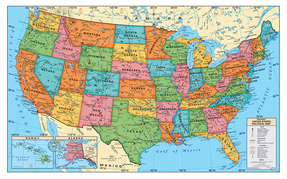
What are some features on a map that help you read it?
Key/Legend, scale, compass rose, and title.
routes, tourist attractions, climate zones, and title.
Grid lines, elevation markers, compass rose, scale.
Which of the following scenarios reflect a positive aspect of geospatial technologies?
Using data from different sources to map out disaster areas after a hurricane.
High costs for geospatial data acquisition, making it unavailable.
Limited signal in an area leading someone to the wrong direction.
Data of your location and personal information being used without your consent.
Which of the following scenarios reflect a negative aspect of geospatial technologies?

