
 Worksheets
Unit 1 Region/Geography Test II
Total questions: 20
Worksheet time: 10mins
Name
Class
Date
1.
1. The following tools and/or skills are important to use when reading or interpreting maps EXCEPT-
a)
A. Map key or legend
b)
B. compass rose
c)
C. plotting longitude and latitude within a grid system.
d)
D. spinning and tossing a globe
2.
2. North, south, west, east are-
a)
A. cardinal directions
b)
B. specific types of maps
c)
C. states
d)
D. capitals
3.
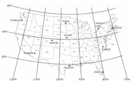
3. What city in the United States is located approximately 32 degrees N, 112 degrees W?
a)
A. Boston
b)
B. Raleigh
c)
C. Phoenix
d)
D. Fargo
4.
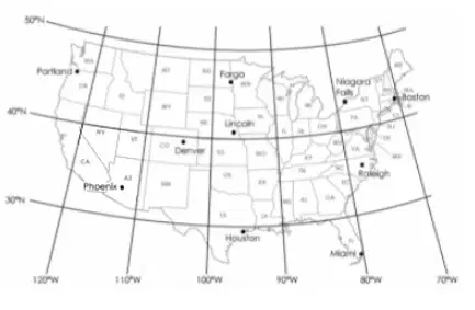
4. What are the approximate latitude and longitude coordinates of Boston?
a)
A. 25 degrees N, 80 degrees W
b)
B. 42 degrees N, 70 degrees W
c)
C. 30 degrees N, 120 degrees W
d)
D. 41 degrees N, 98 degrees W
5.
5. When determining the coordinates on a map or a grid system, which of the following information is needed in order to pinpoint a specific location?
a)
A. Latitude
b)
B. Longitude
c)
C. Cardinal Directions
d)
D. All of the above
6.
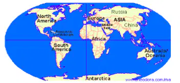
6. Based on the picture below, identify the two hemispheres in which the United States is located.
a)
A. Northern and Western Hemisphere
b)
B. Eastern and Southern Hemisphere
c)
C. Western and Eastern Hemisphere
d)
D. Northern and Southern Hemisphere
7.
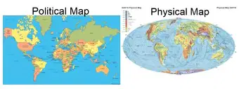
7. The difference between a political map and a physical map is-
a)
A. A political map emphasizes on politics expressed between Democrats and Republicans while physical maps describe the daily weather forecast.
b)
B. A political map uses different colors to determine boundaries between states, countries and continents while a physical map emphasizes on the location of geographical physical features such as mountain ranges, islands, plains, rivers, and lakes.
c)
C. A political map is extremely large in size while a physical map plots the different gymnasiums athletes typically visit in order to maintain their physical fitness and endurance.
d)
D. A political map focuses on some physical features while a physical map emphasizes on the boundaries within a state only.
8.
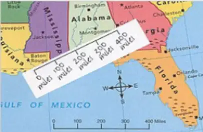
8. Based on the picture above, what can one infer about the purpose of a map scale?
a)
A. A map scales purpose is to determine the coordinates of latitude and longitude on a map
b)
B. A map scales purpose is to determine the weather patterns on a map
c)
C. A map scales purpose is to plot the migration patterns of animals.
d)
D. A map scales purpose is to compare a measurement on a map to the actual distance between locations identified on the map
9.
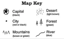
9. The purpose of a Map Key is to-
a)
A. explain the symbols illustrated on a map or chart
b)
B. provide the coordinates of latitude and longitude
c)
C. pinpoint the city's exact location
d)
D. determine how far it is from one location to another
10.
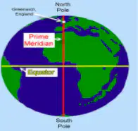
10. The EQUATOR is an imaginary line that is located at 0 degrees, and it divides the earth into two hemispheres. The two hemispheres are-
a)
A. Eastern and Western Hemisphere
b)
B. Southern and Eastern Hemisphere
c)
C. Northern and Southern Hemisphere
d)
D. All of the above
11.

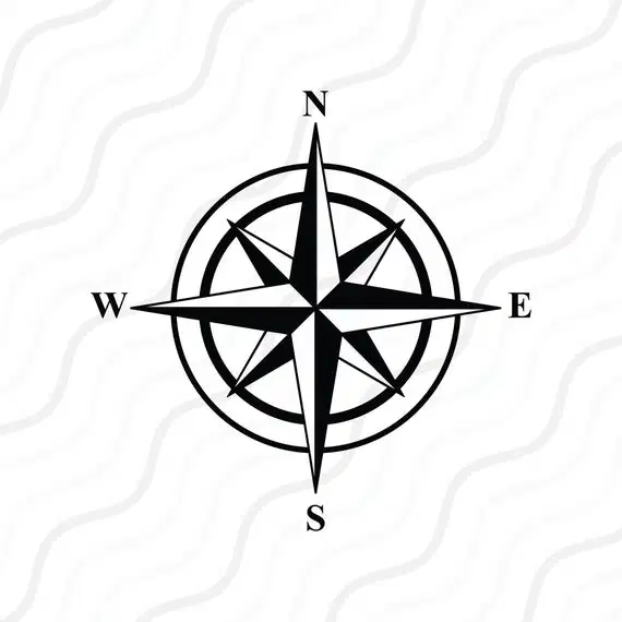
11. Identify the symbol above.
a)
A. map key; it provides an explanation of symbols used in a map or chart.
b)
B. map scale; it compares a measurement on a map to the actual distance between locations identified on the map
c)
C. compass rose; it displays the cardinal directions on a map, chart or compass.
d)
D. grid system; it is used to pinpoint a specific location on a map or chart.
12.
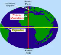
12. The PRIME MERIDIAN is an imaginary line which passes through Greenwich, England, and it is located at 0 degrees longitude as well as divides the earth into two hemispheres. The two hemispheres are-
a)
A. Western and Eastern Hemisphere
b)
B. Northern and Southern Hemisphere
c)
C. Northern and Eastern Hemisphere
d)
D. Southern and Western Hemisphere
13.
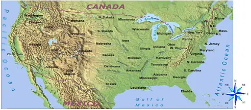
13. Using the United States physical map below, which state is located south of Oklahoma?
a)
A. New York
b)
B. Washington
c)
C. Michigan
d)
D. Texas
14.
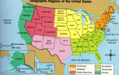
14. Which regions of the United States border the Atlantic Ocean?
a)
A. West and Southwest
b)
B. Southeast and Southwest
c)
C. Northeast and Southeast
d)
D. Midwest and Southeast
15.

15. Which geographical physical features covers the majority of the Western region of the United States?
a)
A. Appalachian Mountains
b)
B. Atlantic Ocean
c)
C. Rocky Mountains
d)
D. Gulf of Mexico
16.
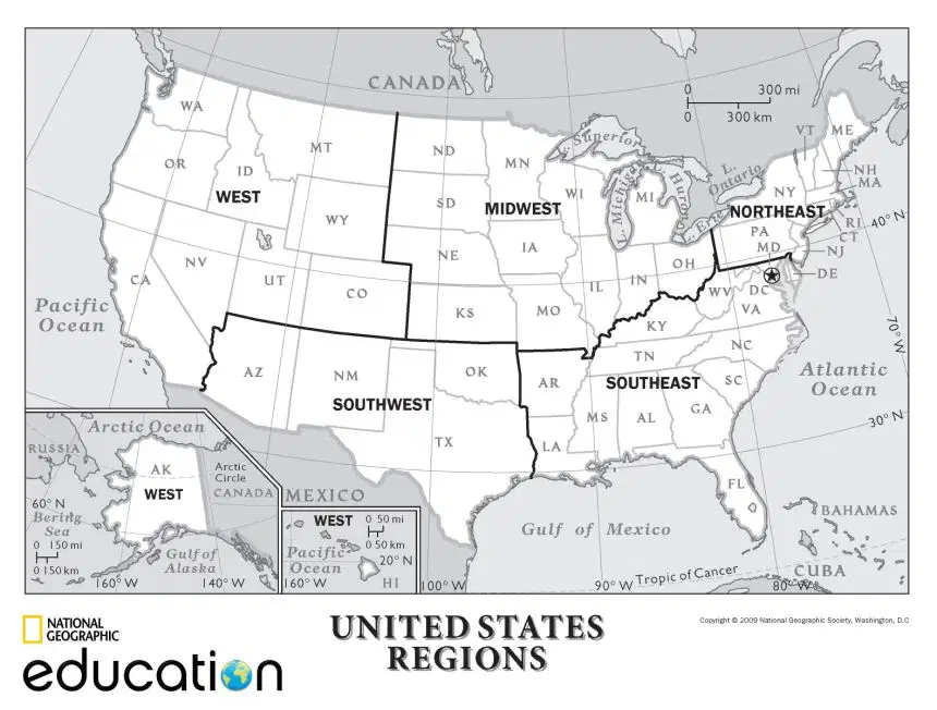
16. Which large body of water borders the Southwest and Southeast regions of the United States?
a)
A. Gulf of Mexico
b)
B. Pacific Ocean
c)
C. Great Lakes
d)
D. Atlantic Ocean
17.
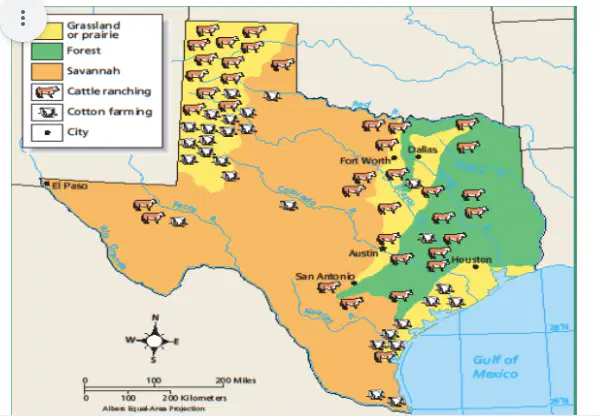
17. Using the map above infer which statement is correct.
a)
A. There are only five rivers in Texas
b)
B. The majority of Texas is covered by forest
c)
C. The majority of Cotton farming is done in the Savannah
d)
D. Very little cotton farming happens in the Northeastern part of Texas
18.
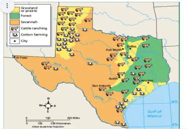
18. Most of west Texas is-
a)
A. A savannah
b)
B. A Forest
c)
C. Grassland
d)
D. Full of cotton farming
19.
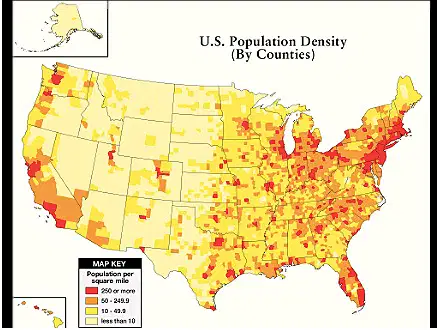
19. Which region of the United States has the highest population density?
a)
A. Northeast
b)
B. Southwest
c)
C. West
d)
D. Northwest
20.
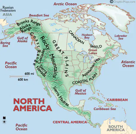
20. Which large bodies of water is close to the Appalachian Mts?
a)
A. Gulf of Mexico
b)
B. Pacific Ocean and Atlantic
c)
C. Atlantic Ocean and the Gulf of Mexcio
d)
D. Arctic Ocean
100 %

