
 Worksheets
Lewis - Chapter 2 Assessment - Texas Regions
Total questions: 14
Worksheet time: 1hrs 10mins
Name
Class
Date
1.
What type of vegetation might you find in the Mountains and Basins region of Texas?
Look on page 76 to find the answer!
a)
cotton
b)
cacti
c)
pecan trees
d)
pine trees
2.
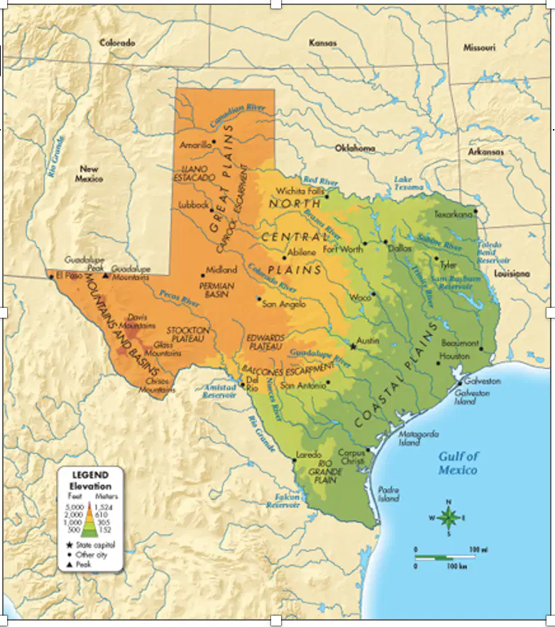
Which of the following best describes the North Central Plains region?
Page 84 will help you with the answer or use the map and your smart brain!
a)
A flat region that borders Oklahoma.
b)
A wet region that borders the Gulf of Mexicol
c)
Hot region that borders New Mexico.
d)
Dry region that borders the Rio Grande.
3.
Which statement best describes the distribution of towns in the North Central Plains region of Texas?
Check out page 87 to find the answer!
a)
They were originally located near railways.
b)
They were originally located new busy ports.
c)
They were separated from each other by deep valleys.
d)
They were separated from each other by mountains.
4.
What is the highest point in Texas?
Find the answer on page 76!
a)
El Capitan
b)
Guadalupe Peak
c)
Eduards Plateau
d)
David Mountians
5.
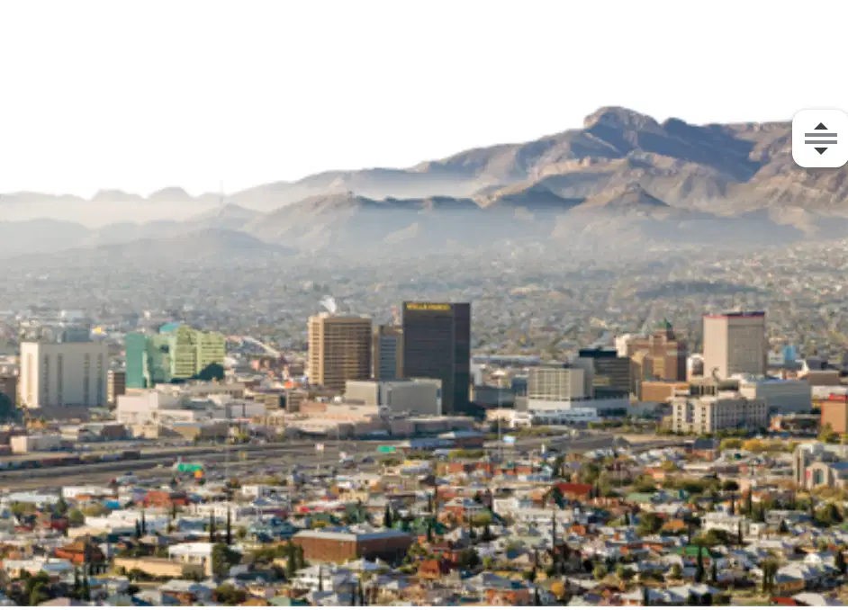
Look at the photo. In which region of Texas is this city located? What do you see in the background that might help you with the answer?
a)
Mountains and Basins
b)
Great Plains
c)
North Central Plains
d)
Coastal Plains
6.
Why was El Capitan an important landmark for early settlers?
Read page 79 to find your answer!
a)
It provided a great view and helped them see a large area at once.
b)
It helped them find their way through the Guadalupe Pass.
c)
It helped them find their way home in case they got lost.
d)
It served as an important trading post with American Indians.
7.
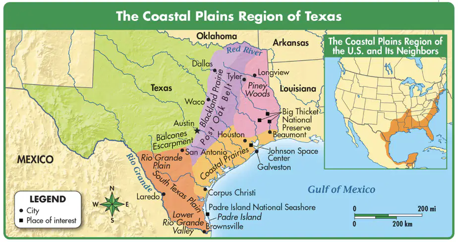
Which of the following is part of the Coastal Plains region of the United States? Use the map to find your answer! Look at the small map on the side, that will be SUPER helpful!
a)
West Texas
b)
California
c)
Florida
d)
Great Lakes
8.
Why did people build national parks in Texas?
Use your big, smart brain to think through this one before you pick your answer!
a)
To protect the state's landforms
b)
To protect the state's natural resources
c)
To protect the state's vegetation
d)
All of the answers
9.
What is a way people modify the land to make it better for farming?
The answer is found on page 93!
a)
irrigation (sprinklers)
b)
mining
c)
tourism
d)
conservation
10.
Which of the following contrasts the climate in the Mountains and Basins region and the Coastal Plains region? Think about what you know about the mountains and the coastal plains. Are mountains
a)
Both regions have hot summers and cool winters.
b)
Both regions are hot and dry.
c)
The Mountains and Basins region is dry; the Coastal Plains region is wet.
d)
The Coastal Plains region has mild temperatures; the Mountains and Basins region is very cold.
11.
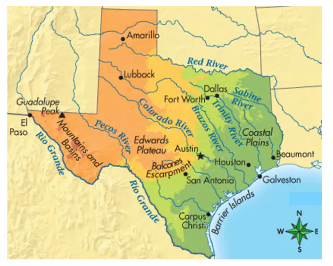
BONUS: Which TWO rivers form natural borders between Texas and other states/countries?
a)
Red River
b)
Brazos River
c)
Rio Grande
d)
Trinity River
12.

BONUS: Which title would be best for this map?
a)
Political Map of Texas
b)
Population Map of Texas
c)
Physical Map of Texas
d)
Pretty Map of Texas
13.

BONUS: Based on this map, what city has the LOWEST elevation?
a)
Austin
b)
Beaumont
c)
Fort Worth
d)
Amarillo
14.
BONUS: Which of the following landforms found in Texas would most likely encourage settlement by farmers and ranchers?
a)
Canyons
b)
Plateaus
c)
Plains
d)
Mountians
100 %

