
Font size
S
M
L
XL
 Worksheets
Unit 1 Lesson 1 Geography Basics 2025
Total questions: 43
Worksheet time: 27mins
Name
Class
Date
1.
1. Where is the Equator located on the earth, and at what degrees is it marked at?
a)
Includes the Prime Meridian, and is marked at 0 degrees longitude
b)
Located halfway between North and South poles: Marked at 0 degrees latitude
c)
Located halfway around the Prime Meridian: Marked at 180 degrees longitude
d)
Located close to the North Pole: Marked at 90 degrees latitude
2.
2. The Equator divides the Earth creating two hemispheres, what are they?
a)
Western Hemisphere and Eastern Hemisphere
b)
Prime Meridian and the Equator
c)
Northern Hemisphere and Southern Hemisphere
d)
Cardinal Directions and intermediate directions
3.
3. In what direction are Longitude lines drawn in?
a)
North to South
b)
Northwest to Southwest
c)
East to West
d)
Northeast to Southeast
4.
4. The Prime Meridian splits the earth in half creating two other Hemispheres', what are they called?
a)
Western Hemisphere and Eastern Hemisphere
b)
Cardinal Directions and Intermediate Directions
c)
Prime Meridian and the Equator
d)
Northern Hemisphere and Southern Hemisphere
5.
5. What are the four physical or human features that a Region can share?
a)
Compass Rose, Scale Bar, Title, Locator Map
b)
Cardinal Directions, Intermediate Directions, Water, Human Settlement
c)
Hemispheres, Longitude, Latitude, Global Grid
d)
Climate, Landforms, Culture, or History
6.
6. What is a Geographic Information System (GIS)?
a)
Originally designed for the Military
b)
A computer based system that stores and uses information linked to geographic locations.
c)
Show's the Earth's surface using aerial photos taken from the air
d)
A network of 24 satellites to help pinpoint locations on Earth
7.
7. What are 6 ways Geographers show Earth's surface?
a)
North, Southeast, West, Southwest, East
b)
Location, Region, Human Environment Interaction, Place, and Movement
c)
Title, Map Key, Scale Bar, Map Grids, Compass Rose
d)
Globes, Photographs, GIS, GPS, Digital Maps, and Map Projections.
8.
8. What are three different types of Projection Maps?
a)
Robinson, Mercator, and Equal Area
b)
Distortion, Projection, and Scale
c)
Political, Physical, and Road
d)
Global, Geographic, and Photographic
9.
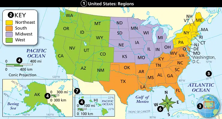
9. Which of the following numbers is the locator map?
a)
1
b)
3
c)
7
d)
5
10.
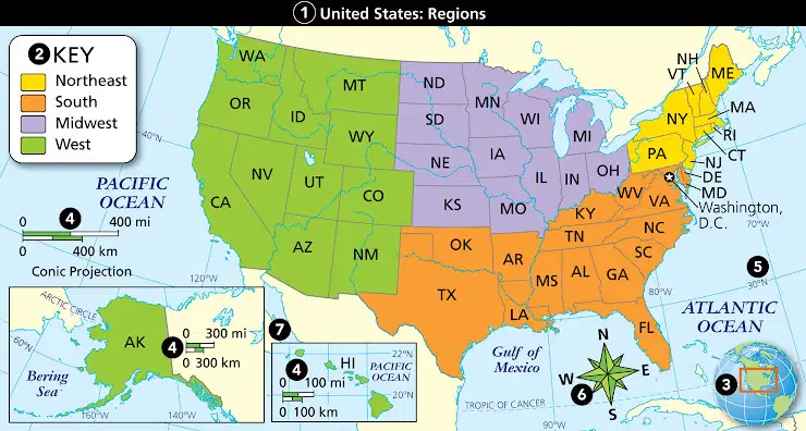
10. Which of the following numbers is the compass rose?
a)
6
b)
4
c)
3
d)
1
11.
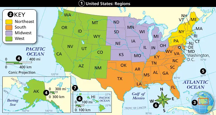
11. Which of the following numbers is the title?
a)
4
b)
7
c)
1
d)
2
12.
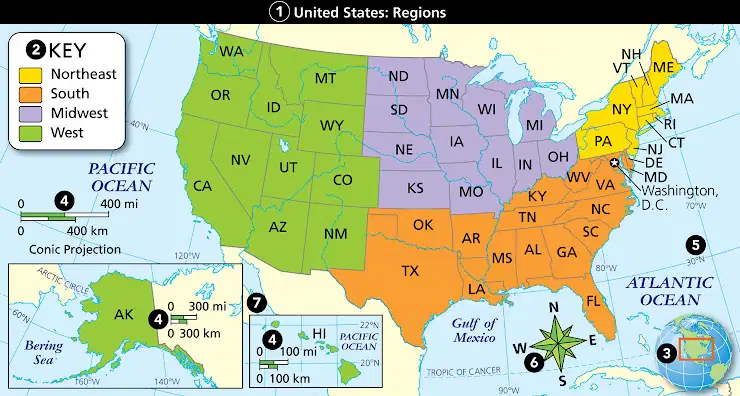
12. Which of the following numbers is the Scale bar?
a)
4
b)
3
c)
7
d)
2
13.
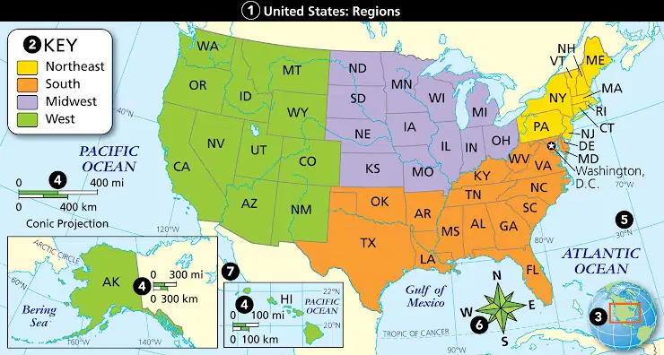
13. Which of the following numbers is the key/legend?
a)
3
b)
4
c)
2
d)
5
14.
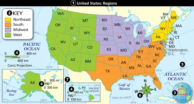
14. Which of the following numbers is the map grid?
a)
7
b)
5
c)
4
d)
2
15.
15. What does a political map show?
a)
Digital Maps, Map Projections, GPS
b)
Title, Key, Locator Map, Scale
c)
Shows physical or natural features of a place, like elevation
d)
Countries, states, capitals of countries, or centers of government
16.
1. In order to study the earth, two things that geographers must do first is measure it, and locate points on the surface.
a)
True
b)
False
17.
2. Latitude lines are drawn from North to South.
a)
True
b)
False
18.
3. The lines of longitude and latitude create the global grid.
a)
True
b)
False
19.
4. Two ways to describe LOCATION within Geography's Five Themes are Relative Location and Absolute Location.
a)
True
b)
False
20.
5. PLACE in Geography's Five themes can refer to how and why people, goods, and ideas move from place to place.
a)
True
b)
False
21.
6. A globe is a proper scale model of the Earth itself
a)
True
b)
False
22.
7. A satellite photo of the Earth show great details of the Earth's surface.
a)
True
b)
False
23.
8. Digital maps are often times stored within our textbooks, and notebooks.
a)
True
b)
False
24.
9. Maps of Earth are never distorted.
a)
True
b)
False
25.
10. A physical map shows physical, or natural, features of a place.
a)
True
b)
False
26.
1. There are a total of ________________ degrees in Latitude.
a)
180
b)
360
27.
2. The 0 degree line of longitude, which runs through Greenwich Village, England is called the ____________.
a)
Prime Meridian
b)
Equator
28.
3. There are a total of ________ degrees in the lines of Longitude.
a)
90
b)
360
29.
4. Movement as one of Geography's Five Themes is about how and why ________________________________ move from place to place.
a)
people affect their environment and how their environment affects them
b)
people, goods, and ideas
30.
5. Human-environment interaction is about how
a)
people, goods, and ideas
b)
people affect their environment and how their environment affects them
31.
6. A Global Positioning System is a network of 24 satellites which help ______________________________.
a)
show earth's surface with aerial photos taken from the air.
b)
pinpoint locations on Earth with great accuracy.
32.
7. An equal area map is a map with __________________, and a robinson map is a map with _________________.
a)
correct size of landmasses/nearly correct size and shape of most land areas
b)
Title and key/distortions and projections
33.
8. A Mercator map is a map with ____________________, and an Equal Area map is a map with _________________.
a)
Compass Rose and scale bar/Map's grids and locator map.
b)
Correct shapes and directions/correct size of landmasses.
34.
Study of human and non-human features is (a) ?
35.
(a) are compass directions Northeast, Southwest, Northwest, and Southeast.
36.
Relative size is (a) ?
37.
(a) is position North or South of the Equator measured in degrees.
38.
North, East, South, and West are (a) ?
39.
Way to map Earth on a flat surface is (a) ?
40.
(a) is loss of accuracy?
41.
(a) is position in degrees East or West of the Prime Meridian.
42.
(a) is the influence of two or more things on each other.
43.
An arrangement, structure, or trend is a (a) ?
Reset

