
 Worksheets
GED101 Surveying 1 Quiz 1
Total questions: 20
Worksheet time: 10mins
.......... is the art and science that determines the dimensional relationships between physical features, natural and artificial, on, below, or above the Earth’s surface.
Geology
Biology
Surveying
None of the above
................... is that discipline concerned with the collection, collection, distribution, distribution, storage, analysis, processing, presentation of geographic data or geographic information.
Geodesy
Geomatics
Surveying
All of the above
Four Main Tasks in Geomatics inlcude ........................
Collection and processing of geodata
Development and management of geodatabases
Analysis and modeling of geodata
All of the above
GIS/Spatial Analytics, Earth observation, GNSS, and Scanning. All these belong to the ...............................
Geospatial technology
Geology
Remote sensing
None of the above
Working from the part to the whole is a key principle of surveying.
True
False
In triangulation surveying, all angles are measured.
True
False
Earth’s curvature is considered in ............................. surveying
Plane
Geodetic
Cadastral
None of the above
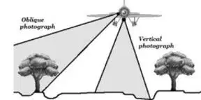
The figure shows an example of ................. surveying
mining
route
aerial
marine
The concept of surveying is broader than geomatics
True
False
Distance measurement is generally regarded as the most fundamental of all surveying observations
True
False
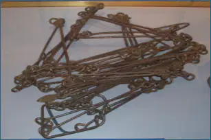
The figure shows ...........
Metalic tape
surveying chain
EDM
None of the above
Accuracies of EDM instruments are quoted in two parts:
scalar and constant
sag and tension
slope and scalar
All of the above
1 ppm means ........................
1 part per portion
1 part per million
1 portion per perimeter
Noe of the above
A distance of 1000,000 mm is measured by EDM, the expected error is ............................
8 mm
40 mm
4 mm
2.4 mm
..................... is the ratio between the distance on a map and the corresponding distance on the Earth's surface
Tape
Scale
Surveying
Map
It is expressed as a ratio or fraction, typically written in the form of 1/𝑋 or 1:𝑋
RF Scale
Verbal Scale
Weight Scale
None of the above
If 1 cm length of drawing represents 5m length of the object, then the RF is ..............
1:250
1:500
1:5000
none of the above
A .............. scale typically consists of a line or bar marked with labeled intervals that represent a specific distance on the ground
engineering
numerical
graphical
all of the above
Taping is NOT a direct method of distance measurements.
True
False
Subtense bar uses anglular measurements to compute the distance.
True
False

