
NEW
Font size
 Worksheets
Ilmu Pelayaran Datar I
Total questions: 40
Worksheet time: 3mins
Given Position A 22°42' S and Position B 18°51' S, what is the Delta latitude?
41°33' N
41°33' S
03°31' S
03°31' N
Determining the position of a ship on a nautical chart using celestial bodies is called ..........
Navigation Science
Astronomical Navigation Science
Flat Navigation Science
Electronic Navigation Science
Determining the time in a place will be based on.....
Latitude
Degree
Parallel
Longitude
The line that divides the Earth into northern and southern parts is called...
Equator
Degree
Line
Axis of the Earth
Two points on Earth where one point is located in the northern hemisphere and one point is located in the southern hemisphere are called....
Latitude Lines with the Same Name
Latitude Lines with Different Names
Difference of Latitude Lines
Latitude Lines
The science that studies how to navigate a ship from the point of departure to the destination is called ..........
Sailing Science
Machine Science
Navigation Science
Astronomical Sailing Science
The lines of latitude in the Earth's hemisphere consist of:
North and South Latitude
South Latitude
West and East Latitude
North Latitude
The time taken by the Earth to rotate on its axis in one complete rotation is...
23 hours 57 minutes 3 seconds
23 hours 57 minutes 4 seconds
23 hours 56 minutes 3 seconds
23 hours 56 minutes 4 seconds
The circle that divides the Earth into two equal parts is called .......
Great Circle
Small Circle
Earth's Axis
Equator
Given Position A 22°42' N and Position B 18°51' S, what is the Delta latitude?
03°51' N
41°33' N
41°33' S
03°51' S
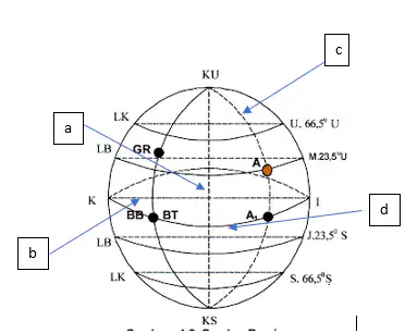
In the image beside, the direction of the arrow labeled 'a' is called
line
earth's axis
equator line
degree
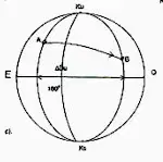
This image represents
Same latitude
Different latitudes
Same longitude
Different longitudes
A ship is located at a longitude of 72°25.2' E. If it is known that every 1° of longitude = 4 minutes of time, what is the time difference from Greenwich?
4 hours 45 minutes 12 seconds
4 hours 49 minutes 40.8 seconds
5 hours 12 minutes 30 seconds
3 hours 59 minutes 48 seconds
Two ships are positioned as follows:
Ship A: 022°42’ N
Ship B: 018°51’ S
What is the type of latitude of both ships and what is the difference in latitude?
Same latitude, Δli = 03°51’
Different latitudes, Δli = 41°33’
Different latitudes, Δli = 41°33’
Same latitude, Δli = 04°09’
A ship is known to be at a latitude of 45°, determine the length of one minute of degree in that area.
1,861 m
1,855 m
1,852 m
1,843 m
A ship sails from port A (02°20' N) to port B (05°30' N).
Based on this data, what is the difference in latitude (Δ li) between the two locations?
02°10’
03°10’
05°00’
07°50’
Ship A is located at 120° East longitude and Ship B at 105° East longitude.
If Ship A reports the local time as 08:00, determine the local time of Ship B.
07:00
08:00
09:00
10:00
Two navigation officers have different opinions about the shape of the Earth:
Officer A: The Earth is a perfect sphere.
Officer B: The Earth is an ellipsoid that is flattened at the poles.
Based on modern geodesy theory and satellite evidence, evaluate which opinion is more accurate.
Both are wrong, the Earth is flat at the poles.
Only Officer A is correct because the Earth is a perfect sphere.
Only Officer B is correct because the Earth is slightly flattened at the poles.
Both are correct because the Earth is a perfect ellipsoidal sphere.
In position determination exercises, Cadet A mistakenly wrote the coordinates 06°28' S – 002°38' N as having the same latitude.
Evaluate the error that occurred.
Correct because both are in the south.
Incorrect because the latitudes are not the same (one is in the south and the other is in the north).
Correct because both are still within one degree.
Incorrect because both are longitudes.
A ship departs from the position 087°00' E heading towards 092°15' E. Determine the difference in longitude.
04°15’
05°15’
06°00’
07°10’
What is the ZT if your longitude 121°45 E ?
+12 GMT
+11 GMT
+8 GMT
+10 GMT
In the following conversion what is the value of 1 NM =…
1582 m
1852 m
1882 m
1552 m
What the meaning of Great circle ?
A circle on a sphere whose plane passes through the center of the sphere
A geographic coordinate that specifies the east–west position of a point on the Earths
surface, or the surface of a celestial body
A circle whose plane pass through the center of the sphere
A geographic coordinate that specifies the north–south position of a point on the
Earths surface
The Prime meridian is at
Greenland
Greenwood
Meccah
Greenwich
What the meaning of Longitude ?
a circle whose plane pass through the center of the sphere
a geographic coordinate that specifies the east–west position of a point on the Earth's
surface, or the surface of a celestial body
a geographic coordinate that specifies the north–south position of a point on the
Earth's surface
a circle on a sphere whose plane passes through the center of the sphere
If the radius of the Earth at the Equator is 6,378 km, what is the circumference of the Equator?
40,008 km
40,075 km
21,600 km
6,357 km
A sailor wants to calculate the distance of sailing around the earth using the unit nautical miles. If 1 degree of latitude = 60 nautical miles, what is the total circumference of the earth in nautical miles?
18,000 nautical miles
21,600 nautical miles
40,075 nautical miles
24,000 nautical miles
Use the formula for circumference C=2×π×R. If the radius of the Earth at the poles is 6,357 km, then the circumference of the Earth through the poles is approximately …
40,008 km
40,075 km
6,378 km
67 km
If a sailor sails from latitude 0° to latitude 90° S, what is the distance traveled in nautical miles?
60 nautical miles
600 nautical miles
5,400 nautical miles
5,400 land miles
Given the equatorial circumference of 40,075 km and the polar circumference of 40,008 km. Calculate the difference in the circumference of the Earth between the two.
75 km
67 km
57 km
87 km
The region with an east-west orientation and located at mid-latitudes is most accurately mapped using the …
Equatorial Cylinder
Conical Projection
Planar Gnomonic
Orthographic
Ships around the equator that require conformity. The appropriate projection is …
Mercator
Polyconic
Gnomonic
Orthographic
The Singapore-Japan ship route through the mid-latitudes, the best projection is ...
Mercator
Conical
Planar
Orthographic
The great circle route is determined using …
Mercator Chart
Gnomonic Chart
Lambert Conformal
Polyconic Chart
The polar regions appear to widen on the Mercator projection. The impact is …
Apparent distance is short
Direction cannot be used
Shape of the area remains accurate
Scale is inconsistent at high latitudes
Cylinder projection distortion occurs …
Minimal distortion at the poles
Small distortion around the equator
Largest distortion at the standard parallel
Uniform distortion
Great circle lines become straight lines in gnomonic because …
Projection point at the pole
Projection point at the center of the earth
Surface of the cone
Equidistant lines
Mercator projection is called conformal because …
It preserves area
It preserves distance
It preserves angles
It preserves scale at the poles
The gnomonic projection is superior for long distances because …
It preserves area
It displays great circles as straight lines
It preserves angles
It has no distortion
Planar projection is not suitable for global maps because …
Very accurate for shape
No distance distortion
Accurate only at the tangent point
Accurate for all latitudes

