
 Worksheets
Natural Hazard Unit Review
Total questions: 30
Worksheet time: 1hrs 6mins

What area has the highest risk of wildfire?
north
south
east
west

What infomation should representatives in Washington DC consider to decide if they should vote for a mitigation project for a natural disaster in Louisiana?
agriculture industries of the past in Louisiana
extreme temperatures of the various seasons in Lousiana
cost and annual deaths due to the natural disaster
how it will look to citizens if they don't acquire money to fight volcano eruptions

Tornado ally is an area of the US where tornadoes frequently occur. What region could be considered "wildfire ally" and which reasoning statement best supports your choice of region?
Region A has 80 wildfires annually.
Region B has 40 wildfires annually.
Region C has 75 wildfires annually.
Region D has 5 wildfires annually.

Which statement is true?
There are more hurricanes than landslides, but cost the same.
Floods occur more often than landslides and droughts and cause more deaths.
Droughts cost less and do not occur as often as floods.
Landslides and droughts occur less and cost less than floods, but cause more deaths.
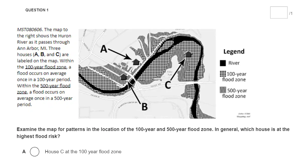
Examine the map for patterns in the location of the 100-year and 500-year flood zone. In general, which house is at the highest flood risk?
House C at the 100 year flood zone
House B at the 500 year flood zone
House A outside the 100 year and 500 year flood zones

What kind of plate boundary is Mt. Everest located on?
Divergent boundary
Transform boundary
Convergent boundary
Farkas boundary

According to the data in the image, the city least likely to experience a snow hazard in the future is
Escanaba, more snowfall
Traverse City, more snowfall
Escanaba, less snowfall
Traverse City, less snowfall

Humans can reduce the effects of natural hazards by
by identifying and avoiding high-risk locations
by improving construction methods where they live
by developing warning systems
All of the above (choose this if ALL are correct and not the others)

Which factor below weakens a hurricanes category strength? (a)

The ring of fire is where the pacific plate meets other tectonic plates at a tectonic plate boundary. What are the risks living on the shores of the Ring of Fire? Choose up to 3 answers.
Blizzards
Earthquakes
Volcanoes
Tsunamis

Which letter represents the most danger to a human population from an earthquake?
(a)

What is something we could put in place to help reduce the loss of lives in the event of an earthquake?
Build new buildings on higher grounds
Modify old buildings so they are more flexible
Force people to move from areas prone to earthquakes
Build smaller buildings

A Doppler radar uses radio waves to bounce off weather systems to determine the severity and speed of a system. This instrument would be best in helping to predict what type of severe weather? (a)

When do tornadoes form?
when warm, humid air collides with cold, dry air
when cold, humid air collides with warm, dry air
when cold air rises through warm air
when the air cools rapidly and forms storm clouds

Which statement best explains a cause-effect relationship between droughts and wildfires?
Drier weather conditions increase the occurrence of severe lightning storms.
Drier weather conditions create high wind gusts.
Drier weather conditions reduce the probability of a wildfire.
Drier weather conditions produce more fuel for a wildfire.

Storm Surge Map of Texas:
Where would be the best place to build a seawall to protect major cities from storm surge during hurricanes?
Between Galveston and Texas City
Between Gulf of Mexico and Galveston
Between Galveston Bay and Trinity Bay
Between Gulf of Mexico and Port Arthur

Why does having lots of plants make flooding slower?
The plants cannot absorb water very fast
The plants' roots are connected to the river
The plants absorb water (interception) so the water takes longer to reach the river
Plants increase run-off

Based on the information provided, which location is affected by the most geographic events?
Western Washington (WA)
California (CA)
Oregon (OR)
Washington (WA)

A city lies near a major fault line. What measures could help reduce the negative impacts of a possible major earthquake? Select three correct answers.
installing warning sirens
training citizens on earthquake readiness
implementing a city response plan
making building out of brick or stone instead of wood
building dams downstream from the city rather than upstream

Which of the following statements are true?
Hurricanes occurred less often than wildfires, but cost more in 2011
Earthquakes occurred less often than landslides, but caused more deaths in 2011.
Tornadoes cost less than wildfires even though there were more tornadoes than wildfires in 2011
Wildfires cost less than hurricanes and tornadoes , but caused more deaths in 2011.
Earthquakes occurred more than landslides, but caused fewer deaths in 2011.

What mitigation measures could help reduce the negative impacts of future volcanic eruptions of Mount St. Helens?
Select 3
Houses could be designed with a strong underground foundation.
Warning sirens could be designed.
An evacuation plan could be organized.
Homes could be made with metal beams instead of wood.
Emergency evacuation roadways could be designed.
Scientists monitoring a large river can give people living near the river prior warning of a coming flood so that they can take action.
What mitigating measures could help reduce the negative impacts of a possible flood?
buildings should be no more than one or two stories in height
building a dam downstream from the town
Prevent new housing from being built in the floodplain
building levees to on the banks of the river
implementing an evacuation plan
What is the Saffir-Simpson Hurricane Wind Scale and how is it used?
The Saffir-Simpson Hurricane Wind Scale is a classification system used to categorize hurricanes based on their wind speed and it is used to estimate the potential damage and flooding associated with a hurricane.
The Saffir-Simpson Hurricane Wind Scale is a scale used to measure the intensity of a hurricane's storm surge and it is used to assess the potential damage to coastal areas.
The Saffir-Simpson Hurricane Wind Scale is a measurement of the amount of rainfall a hurricane produces and it is used to determine the severity of flooding.
The Saffir-Simpson Hurricane Wind Scale is a ranking system used to categorize hurricanes based on their size and it is used to predict the storm surge associated with a hurricane.

There are 4 regions in The United States that are prone to seeing tornadoes. But, despite the fact that there may be 4 of them, each “alley” is completely different than the other. For example, in tornado alley, we’re likely to experience thunderstorms that are called “LP Supercells”. The LP stands for, ” low precip.” and means that tornadoes can be spotted miles away and often move rather slowly.
Once you get into Dixie Alley, Hoosier Alley and even Carolina Alley, then you start to experience storms known as “HP Supercells”, or “High Precip storms” which means that tornadoes are often wrapped in rain and cannot be detected as easily.
Where do most tornadoes in the United States occur?
Tornado Alley and Hoosier Alley
Tornado Alley and Carolina Alley
Dixie Alley and Hoosier Alley
Tornado Alley and Dixie Alley

This figure presents the hazard causing the highest transport infrastructure exposure in each region. The pie chart shows the relative percentage of land area (excluding areas with insufficient data) where that specific hazard causes the highest exposure
Match the Natural Hazard event with the land area most effected according to the map
Earthquakes
Alaska
Cyclones
Southeast Asia
Surface Flooding
Everywhere
River Flooding
Africa
Coastal Flooding
Northern Hemisphere

Engineers built this retaining wall to prevent mass wasting near the garage door, however over time debris is falling past the wall.
How should the engineers modify the design of the retaining wall in order to improve its ability to reduce the impacts of future mass wasting events?
Use a different material for the wall
Decrease the height of the wall
Increase the height of the wall
Make the wall thinner
Which factor does NOT contribute to mass wasting?
Water
Over steepened slopes
Lack of vegetation
Earthquakes
Buildings

What is the best way to reduce the impact of an area at risk of mass wasting?
Identify and monitor areas at risk with LIDAR
There's nothing that can be done
Remove plants and trees in the area
Build heavy concrete walls on top of slope to stabilize it

