

wayground logo

Free Printable Worksheets

NEW

Font size

S
M
L
XL
Worksheets

Latin America & the Caribbean Test

Total questions: 50

Worksheet time: 25mins

Name
Class
Date
1.

Which of the following terms best fits the region we call Latin America?

a)
physical region - the entire region shares the same landforms
b)
language region - shares a common language base or family
c)
functional region - tied together by economic relationships
d)
ethnic region - everyone is of the same racial or ethnic group
2.

Which vertical zone is correctly matched with its major products?

a)
tierra templada - sugar cane
b)
tierra helada - flowers, fruit, vegetables
c)
tierra fria - coffee, and grazing animals
d)
tierra caliente - tropical fruit such as bananas and pineapple
3.
3. Which country colonized Brazil and gave the country its official language?
a)
Spain
b)
Portugal
c)
France
d)
England
4.

Which of these is true of the cerrado?

a)
it has a tropical wet and dry climate
b)
it is covered with a tropical rainforest
c)
it is arid, so agriculture is not possible
d)
it is located south of the Pampas
5.

Why was Brasilia selected as a capital city?

a)
it is in the Sierra Madre Mountains, where rich soil can support a growing population
b)
the coastal location was picked to encourage trade
c)
the government made a commitment to develop the interior of the country
d)
the strategic location was a stopping point on long sea journeys around the continent
6.

Slash-and-burn agriculture is an adaptation to -
a)
poor tropical soil, where spreading ash helps add nutrients to the soil
b)
being forced to move because of the labor needs
c)
steep slopes where soil erosion is a serious risk and there is little room to plant
d)
high elevation areas where the growing season is too short for permanent crops
7.

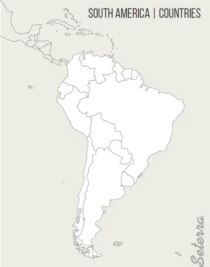
Use the map to answer the following question: Which South American country does not border the Pacific Ocean?

a)
Peru
b)
Chile
c)
Ecuador
d)
Brazil
8.

Which factor is used to measure the level of economic development of a country?

a)
urban-rural ratio
b)
climate
c)
language
d)
religion
9.

What is the major purpose of NAFTA?

a)
to protect goods produced in the U.S. from foreign competition, using tariffs
b)
to promote cooperation on environmental issues between member countries
c)
to boost trade between member countries and reduce trade barriers
d)
to create an organization to oversee immigration and labor market issues
10.

Which of the following countries in Latin America has oil resources?

a)
Panama
b)
Venezuela
c)
Chile
d)
Paraguay
11.

Mestizo, the term used to describe people of mixed Spanish and Native American heritage, is a cultural blend found in both Mexico and this region -

a)
Caribbean
b)
Central America
c)
South America
d)
Brazil
12.

Tourism attracts people to the Greater and Lesser Antilles of this region -

a)
Mexico
b)
Caribbean
c)
Central America
d)
South America
e)
Brazil
13.

In 1882, this region declared independence from Spain -

a)
Mexico
b)
Caribbean
c)
Central America
d)
South America
e)
Brazil
14.

UNASUR is an organization in this region that promotes trade and political integration -

a)
Mexico
b)
Caribbean
c)
Central America
d)
South America
e)
Brazil
15.

86% of this region's population resides in cities, and the government is encouraging migration to the area's interior -

a)
Mexico
b)
Caribbean
c)
Central America
d)
South America
e)
Brazil
16.

In 1914 the Panama Canal, a crossroads of world trade, opened in this region -

a)
Mexico
b)
Caribbean
c)
Central America
d)
South America
e)
Brazil
17.

In 1822, this region declared independence from Portugal -

a)
Mexico
b)
Caribbean
c)
Central America
d)
South America
e)
Brazil
18.

Maquiladoras, factories that import parts and assemble a product for export, can be found here -

a)
Mexico
b)
Caribbean
c)
Central America
d)
South America
e)
Brazil
19.

During the 1820s, Simon Bolivar led many countries of this region in their fight for independence from Spain -

a)
Mexico
b)
Caribbean
c)
Central America
d)
South America
e)
Brazil
20.

In 1521, Hernan Cortes conquered the Aztec Empire in this region -

a)
Mexico
b)
Caribbean
c)
Central America
d)
South America
e)
Brazil
21.

Along with the Caribbean, this region is an exporter of sugar cane, bananas, citrus fruits, coffee, and spices -

a)
Mexico
b)
Central America
c)
South America
d)
Brazil
22.

In 1533, Francisco Pizarro conquered the Inca Empire in this region -

a)
Mexico
b)
Caribbean
c)
Central America
d)
South America
e)
Brazil
23.

The cultural blends in this region include Native + Portuguese + African -

a)
Mexico
b)
Caribbean
c)
Central America
d)
South America
e)
Brazil
24.

Christopher Columbus reached this region in 1492 -

a)
Mexico
b)
Caribbean
c)
Central America
d)
South America
e)
Brazil
25.

This region is known for calypso and reggae, styles of music that have African influences-

a)
Mexico
b)
Caribbean
c)
Central America
d)
South America
e)
Brazil
26.

This region declared independence from Mexico in 1823 -

a)
Mexico
b)
Caribbean
c)
Central America
d)
South America
e)
Brazil
27.

A country in this region hosted the Olympics in 2016-

a)
Mexico
b)
Caribbean
c)
Central America
d)
South America
e)
Brazil
28.

Oil, fishing, silver, tin, zinc, copper, grain, and livestock help drive the economy of this region -

a)
Mexico
b)
Caribbean
c)
Central America
d)
South America
e)
Brazil
29.

A 1790s slave rebellion in this region led to a nation's independence from France in 1804 -

a)
Mexico
b)
Caribbean
c)
Central America
d)
South America
e)
Brazil
30.

The Aztec, Maya, Toltec, and Olmec are native peoples of this region -

a)
Mexico
b)
Caribbean
c)
Central America
d)
South America
e)
Brazil
31.

Which physical feature is shaded on the map?

a)
Atlantic Ocean
b)
Pacific Ocean
c)
Gulf of Mexico
d)
Caribbean Sea
32.

Which physical feature is shaded on the map?

a)
Atlantic Ocean
b)
Pacific Ocean
c)
Gulf of Mexico
d)
Caribbean Sea
33.

Which physical feature is shaded on the map?

a)
Amazon River
b)
Orinoco River
c)
Parana River
34.

Which physical feature is shaded on the map?

a)
Amazon River
b)
Orinoco River
c)
Parana River
35.

Which physical feature is shaded on the map?

a)
Amazon River
b)
Orinoco River
c)
Parana River
36.

Which physical feature is shaded on the map?

a)
Amazon Basin
b)
Cerrado
c)
Pampas
d)
Llanos
37.

Which physical feature is shaded on the map?

a)
Andes Mountains
b)
Sierra Madre Mountains
c)
Atacama Desert
d)
Isthmus of Panama
38.

Which physical feature is shaded on the map?

a)
Andes Mountains
b)
Sierra Madre Mountains
c)
Atacama Desert
d)
Isthmus of Panama
39.

Which physical feature is shaded on the map?

a)
Andes Mountains
b)
Sierra Madre Mountains
c)
Atacama Desert
d)
Isthmus of Panama
40.

Which physical feature is shaded on the map?

a)
Andes Mountains
b)
Sierra Madre Mountains
c)
Atacama Desert
d)
Isthmus of Panama
41.

Which country is shaded on the map?

a)
Jamaica
b)
Mexico
c)
Honduras
d)
Cuba
42.

Which country is shaded on the map?

a)
Jamaica
b)
Mexico
c)
Honduras
d)
Cuba
43.

Which country is shaded on the map?

a)
Jamaica
b)
Mexico
c)
Honduras
d)
Cuba
44.

Which country is shaded on the map?

a)
Jamaica
b)
Mexico
c)
Honduras
d)
Cuba
45.

Which country is shaded on the map?

a)
Venezuela
b)
Colombia
c)
Peru
46.

Which country is shaded on the map?

a)
Venezuela
b)
Colombia
c)
Peru
47.

Which country is shaded on the map?

a)
Venezuela
b)
Colombia
c)
Peru
48.

Which country is shaded on the map?

a)
Argentina
b)
Brazil
c)
Chile
49.

Which country is shaded on the map?

a)
Argentina
b)
Brazil
c)
Chile
50.

Which country is shaded on the map?

a)
Argentina
b)
Brazil
c)
Chile
