
 Worksheets
24-25 F1 exam revision(2nd)
Total questions: 50
Worksheet time: 25mins
The time zone is ahead of GMT when it travels _______ from GMT.
North
South
West
East
Which country has the most advanced time zones relative to GMT?
Vienna (GMT+1)
Moscow (GMT+3)
Glasgow (GMT+0)
Shanghai (GMT+8)
If it is 3:00 PM in Tokyo (GMT+9), what time is it in Paris (GMT+1)?
6:00 AM
7:00 AM
8:00 AM
9:00 AM
If it is 10:00 AM in Sydney (GMT+10), what time is it in Los Angeles (GMT-8)?
4:00 PM (previous day)
6:00 PM (previous day)
4:00 AM (same day)
6:00 AM (same day)
If you depart Tokyo (GMT+9) at 6:00 PM and fly for 10 hours, what time will it be in London (GMT+0) when you arrive?
7:00 AM
9:00 AM
11:00 AM
1:00 PM
If it is 12:00 PM in London (GMT+0), what time is it in Moscow (GMT+3)?
3:00 PM
9:00 AM
12:00 AM
6:00 PM
Your friend in Iceland (GMT+0) wants to FaceTime you at 9:00 AM their time. You live in Macau (GMT+8). What time will it be for you when they call?
5:00 PM
1:00 AM
5:00 AM
1:00 PM
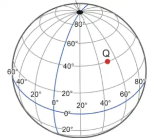
Which of the following is the geographic coordinate of place Q shown in the figure on the right?
50°N, 40°W
40°N, 50°E
50°S, 40°E
40°N, 50°W
Which of the following is the name of 0° longitude?
Equator
Prime Meridian
Tropic of Cancer
International Date Line
Which of the following is the name of 0° latitude?
Prime Meridian
Arctic Circle
Equator
Tropic of Capricorn
Which of the following is the name of 180° of longitude?
Prime Meridian
Tropic of Capricorn
Equator
International Date Line
What is the name of the imaginary line that divides the Earth into the Northern and Southern Hemispheres?
Prime Meridian
Tropic of Capricorn
Equator
International Date Line
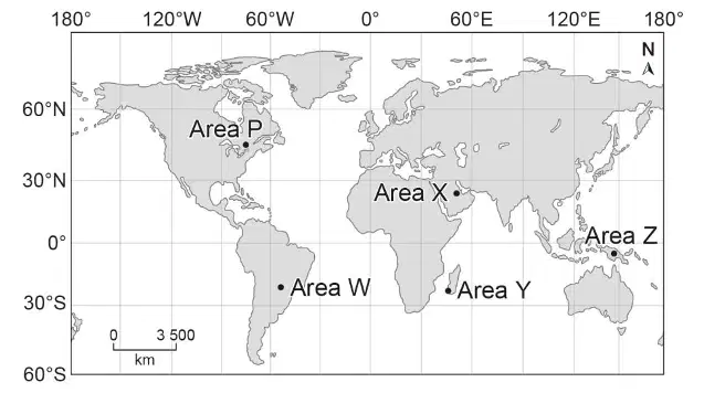
What hemispheres does Area W located in?
(1) and (3) only
(1) and (4) only
(2) and (3) only
(2) and (4) only
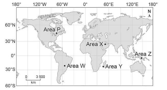
What hemispheres does Area Z located in?
(1) and (3) only
(1) and (4) only
(2) and (3) only
(2) and (4) only
Whole circle bearing refers to the angle measured clockwise from ___x___. What is X?
east
west
north
south
Which of the following statement is correct?
Drought only occurs in desert areas.
When there is a day without rainfall, drought occurs.
In general, the further from the sea, the more humid the air.
Climate change has caused more extreme weather events in recent decades.
Which of the following comparison(s) of hot air and cold air is/are correct?
Hot air is denser than cold air
Hot air is heavier than cold air per volume
Hot air rises and cold air sinks
All of the above
Which of the following statement is correct?
Drought only occurs in desert areas.
When there is a day without rainfall, drought occurs.
In general, the further from the sea, the more humid the air.
Climate change has caused more extreme weather events in recent decades.
Which of the following statement(s) is/are correct?
Hot air sinks
Cold air rises
Winds blow from high-pressure to low-pressure areas
All of the above
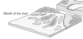
What is the name of this landform?
Delta
Valley
Basin
Hill
Which of the following refers to the long-term state (at least 30 years) of the atmosphere condition at a place.
Weather
Climate
Both
Neither
“The directions on a compass” refers to which of the following way to show direction?
Compass point
Whole circle bearing
Reduced bearing
None of the above
“The angle measured clockwise from the north” refers to which of the following way to show direction?
Compass point
Whole circle bearing
Reduced bearing
None of the above
“The angle measured from the north or the south towards the east or the west” refers to which of the following way to show direction?
Compass point
Whole circle bearing
Reduced bearing
None of the above
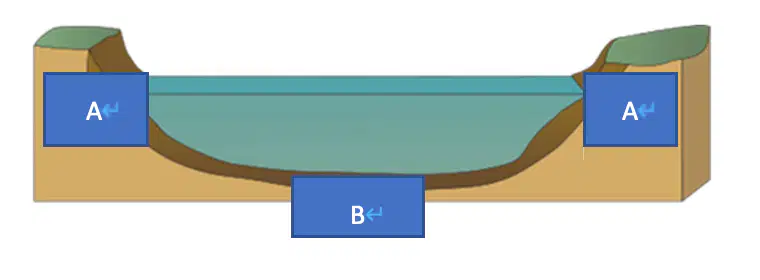
What is A?
River bed
River bank
River discharge
River channel

What is B?
River bed
River bank
River discharge
River channel
Which of the following human activities would increase the risk of flooding in China?
Large-scale deforestation
Reclamation of lakes
Cover land with concrete
All of the above

Refer to the figure below. What are X and Y respectively?
Surface runoff, River discharge
Soil erosion, River discharge
Surface runoff, Channel capacity
Soil erosion, Channel capacity
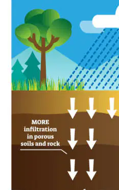
The process shown in the figure is ___________.
surface runoff
precipitation
infiltration
interception
What are the causes of flooding?
Ice melting
Heavy rainfall
Storm surge
All of the above
Which of the following reasons explain why Xinjiang has a low annual rainfall?
It has an inland location.
It lies in the non-monsoon region.
High mountains block onshore winds from reaching the region.
All of the above
Which of the following factors may reduce the capacity of river channels?
Deforestation
Deposition of sediments
Heavy rainfall
Where in China does flooding mainly occur?
North and West
East and South
West and Central
North and East
What is a common cause of flooding in Western China?
Heavy rainfall
Snowmelt
Typhoons
Irrigation
“The breaking of rock” refer to which of the following term?
weathering
erosion
deposition
transportation
Which of the following are the causes of flooding?
increasing river discharge
decreasing river discharge
increasing channel capacity
decreasing channel capacity
Which of the following is not the impacts of deforestation?
Increase the amount of river discharge
Increase the amount of surface runoff
When the rainwater cannot infiltrate into the soil, the amount of surface runoff _(?)_.
Tree _(?)_ can hold the soil to prevent soil erosion.
(a)
In urban areas, the surface of much of the land is covered with _(?)_ which is impermeable.
(a)
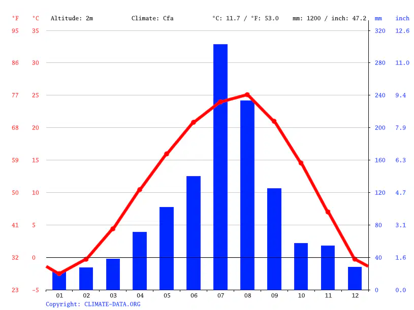
This is the climatic graph of South Korea, in which month will flooding most likely occur there?
March
July
Octocber
December
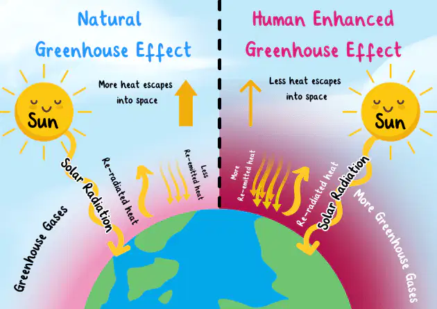
What are the impact of humans enhance the greenhouse effect?
More trees cover
More extreme weather events
We are closer to the Sun
All off the above

