
Font size
 Worksheets
Review Geography skills
Total questions: 50
Worksheet time: 30mins
Which point is located at GR 932453?
Point W
Point X
Point Y
Point Z
What is the local relief between points X and Z?
86 m
141 m
227 m
368 m
What direction is the factory from point Z?
South-east
North-east
South-west
North-west
Which of the following is an example of traditional Aboriginal land management techniques?
Fencing lands
Cultivating crops for sale
Recognising native title
Gathering agricultural products
Using the scale on the map, what is the length of the east-west runway?
0.5 km
1 km
1.5 km
5 km
The linear scale on the map can be represented by which of the following ratio scales?
1 : 500
1 : 25000
1 : 250000
1 : 500000
What is the aspect of the slope at point X?
NE
NW
SE
SW
What is the grid reference for the airport terminal building?
019165
022175
165019
175022
What is the bearing of the summit of Mt Waterview from the airport terminal building?
35°
145°
220°
330°
What is the approximate height of Mt Waterview?
120 m
150 m
180 m
220 m
What is the distance in a direct line from point A to point B?
11 m
900 m
950 m
1100 m
What is the grid reference for the bridge located in the centre of the map?
GR 037578
GR 578037
GR 023562
GR 562023
The cross-section from point C to point D has some unlabelled features indicated by the arrows. Which features would appear if listed from west to east?
Beach, mangroves, road, lagoon
Beach, road, mangroves, lagoon
Lagoon, road, mangroves, beach
Lagoon, mangroves, road, beach
In what direction is Clear Creek flowing?
East
West
South-east
North-west
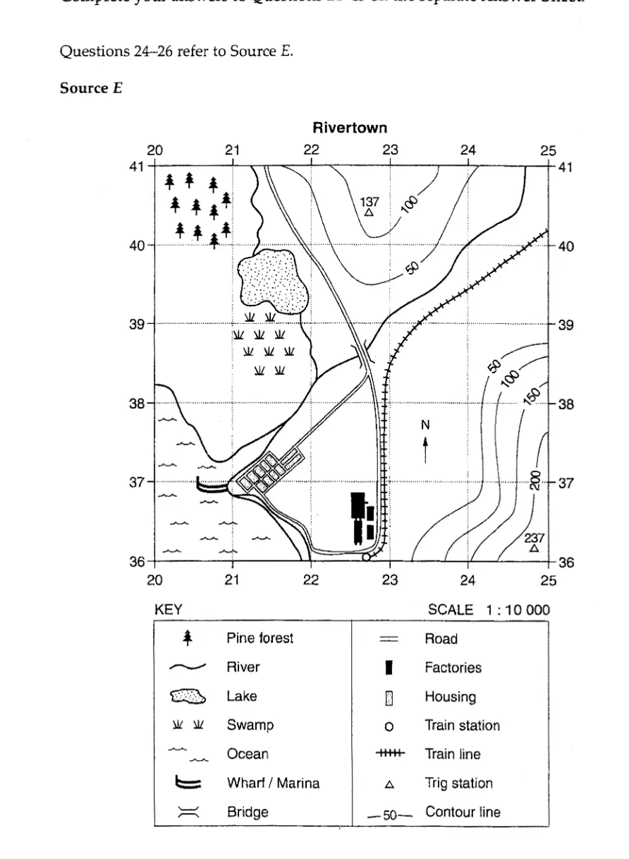
Map of Rivertown with various geographical features and a key.
Map of Rivertown with a legend.
Map of Rivertown with a compass rose.
Map of Rivertown with a scale bar.
Map of Rivertown with various geographical features and a key.
Which of the following gives the distance and direction of the train station from the bridge?
5.5 km north
550 metres north
5.5 km south
550 metres south
Which of the following locations provides the best site for the planting of a tree species that requires a NW aspect and a well-drained site?
GR 203406
GR 246382
GR 212389
GR 234403

Which of the following best represents a cross-section of the topography travelling south-east from the trig station in AR 2240 to the trig station in AR 2436?
A
B
C
D
Use the map on page 34 to answer the questions below. On the diagram below, complete the cross-section from Connor Peak to the field study centre at Madeline Bay. What is the elevation at Connor Peak?
500 meters
750 meters
1000 meters
1250 meters
Use the map on page 34 to answer the questions below. On the diagram below, complete the key below the transect, and draw the correct symbols in the two blank spaces on the transect.
Option A: Draw a tree symbol and a river symbol.
Option B: Draw a mountain symbol and a road symbol.
Option C: Draw a house symbol and a lake symbol.
Option D: Draw a park symbol and a bridge symbol.
What is the approximate relief between Point B and Point C?
30 m
130 m
230 m
330 m
What is the aspect of the slope at Point A?
East
West
North
South
What is the approximate area, in square metres, of the island on which D is located?
7
17
700
7000
Which of the following would most likely represent the transect from Point D to Point B?
The United Nations Convention on the Rights of the Child is an important international agreement. Which of the following best describes the focus of this convention?
Trade links
Human rights
Migration policies
Reconciliation strategies
What is the area reference for the shipwreck?
2071
2171
7120
7221
What is the bearing of the shipwreck from Point C?
30°
130°
230°
330°
What is the gradient of the slope between points A and B?
1:10
1:20
1:30
1:40
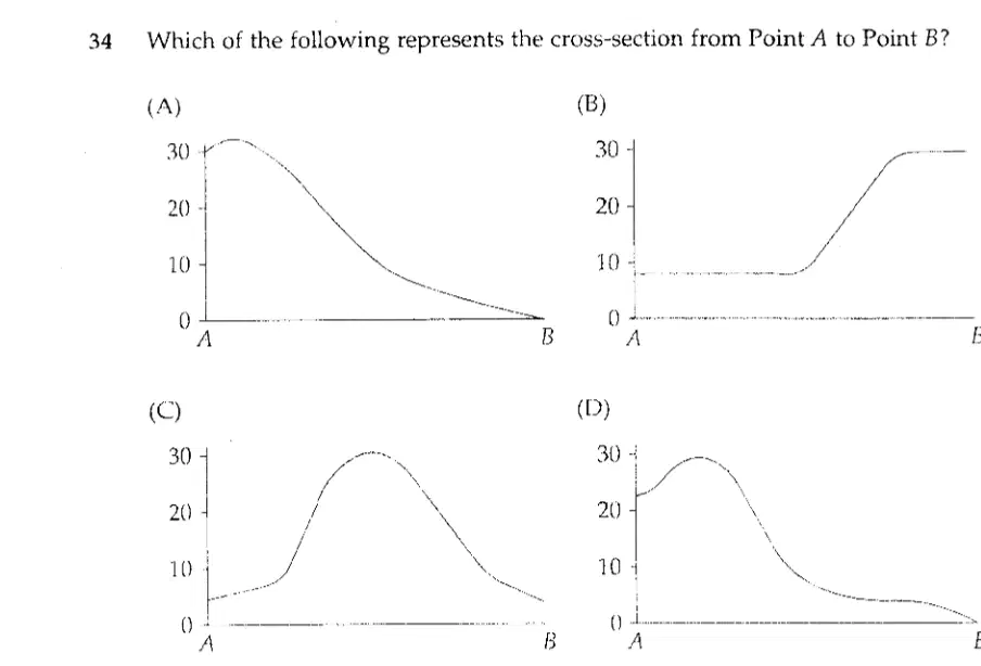
Which of the following represents the cross-section from Point A to Point B?
Which organisation is involved with regional agreements between Australia and its neighbours?
The United Nations (UN)
World Trade Organisation (WTO)
Asia Pacific Economic Cooperation (APEC)
Organisation of Economic Cooperation and Development (OECD)
Draw cross-sections of the following contour patterns. Give each landform a name and state the contour interval. Contour interval =
Contour interval = 10 meters
Contour interval = 20 meters
Contour interval = 30 meters
Contour interval = 40 meters
Draw cross-sections of the following contour patterns. Give each landform a name and state the contour interval. Name of landform:
Mountain with a contour interval of 10 meters
Valley with a contour interval of 20 meters
Plateau with a contour interval of 15 meters
Hill with a contour interval of 5 meters
Draw cross-sections of the following contour patterns. Give each landform a name and state the contour interval. Contour interval =
10 meters
20 meters
30 meters
40 meters
Draw cross-sections of the following contour patterns. Give each landform a name and state the contour interval. Name of landform:
Hill with a contour interval of 10 meters
Valley with a contour interval of 5 meters
Plateau with a contour interval of 15 meters
Ridge with a contour interval of 20 meters
What is the name of the cross-section drawn along A-B?
Section A
Section B
Section C
Section D
What is the name of the cross-section drawn along X-Y?
Section A
Section B
Section C
Section D
What is the contour interval used to draw a contour map of an island with gentle slopes on the west and steep slopes on the east, rising to a central hill 100 metres high?
5 metres
10 metres
15 metres
20 metres
Calculate the vertical exaggeration of the cross section assuming the increments are in centimetres. Use the formula: VE = Vertical scale/Horizontal scale. Shortcut = What 1 cm represents in metres on the horizontal scale over what 1 cm represents in metres on the vertical scale.
1:1
1:10
1:100
1:1000
What is the contour interval of this map?
10 meters
20 meters
30 meters
40 meters
What feature is shown by the contour lines towards the north-western corner?
Hill
Valley
Plateau
Ridge
In which direction is the highest point located?
North
South
East
West
Fill in the contour values for the lines marked 1 to 5 on the map.
10, 20, 30, 40, 50
15, 25, 35, 45, 55
5, 15, 25, 35, 45
20, 30, 40, 50, 60
Estimate the height of the place marked A.
10 meters
20 meters
30 meters
40 meters
Complete this sentence: The closer together the contour lines, the _______ the slope of the land.
steeper
flatter
gentler
smoother
The river is flowing in which direction?
North-East
South-West
What is the contour interval on the Peaceful Cove map?
5 meters
10 meters
15 meters
20 meters
How would you locate features on this map?
By using the map legend
By guessing the location
By asking someone
By ignoring the map
Name the features at these locations: a 280570 b 273582 c 290584
Feature A, Feature B, Feature C
Feature X, Feature Y, Feature Z
Feature 1, Feature 2, Feature 3
Feature Alpha, Feature Beta, Feature Gamma
Calculate: a the length of the walking track b the area of the town c the area of the island
a the length of the walking track
b the area of the town
c the area of the island
What is the direction of the area in this map?
North
South
East
West

