
 Worksheets
Geography Review
Total questions: 80
Worksheet time: 2hrs 31mins

What is the capital of Hawai'i?
Oahu
Juneau
Honolulu
Miami

What is the capital of Alaska?
Anchorage
Unalaska
Vancouver
Juneau

What is the capital of California?
Oakland
San Francisco
San Diego
Sacramento

What is the capital of Oregon?
Portland
Salem
Madison
Harrisburg

What is the capital of Washington?
Olympia
Seattle
Pasco
St. Paul

What is the capital of Arizona?
Oklahoma City
Yuma
Scottsdale
Phoenix

What is the capital of Nevada?
Las Vegas
Carson City
Reno
Topeka

What is the capital of Utah?
Salt Lake City
Fresh Lake City
Salem
Los Angeles

What is the capital of Idaho?
Bismarck
Pierre
Boise
Little Rock

What is the capital of New Mexico?
Albuquerque
Santa Fe
Denver
Nebraska

Denver is the capital of what state?
Colorado
Texas
Connecticut
Wyoming

Cheyenne is the capital of what state?
Colorado
Iowa
Nevada
Wyoming
What are the 5 themes of geography?
Location, place, interaction, movement & region
Location, place, landforms, culture & interaction
Location, place, land-forms, climate & region
Location, land-forms, climate, culture & interaction

True or False: California borders the Pacific Ocean;
True
False
True or False: The Rocky Mountains are in the eastern part of the United States;
True
False
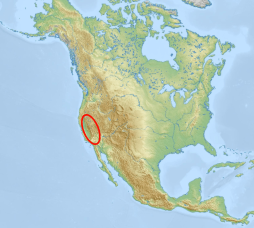
Which land feature is circled on the map?
Rocky Mountains
Sierra Nevada Mountains
Andes Mountains
Amazon Rainforest

Which land feature is circled on the map?
Rocky Mountains
Sierra Nevada Mountains
Andes Mountains
Appalachian Mountains
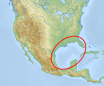
Which water feature is circled on the map?
Caribbean Sea
Gulf of Mexico
Hudson Bay
Black Sea
Which state is east of the Rocky Mountains and south of Kansas?
Oklahoma
Nevada
Wyoming
Nebraska


________________________are the broad expanse of prairie which lie west of the Mississippi River and east of the Rocky Mountains in the United States.
Atlantic Costal Plain
Appalachian Mountains
The Great Plains
The Great Basin

What bodies of water are in the black box on this map?
Great Lakes
The Gulf of Mexico
The Hudson Bay
The Mississippi and Missouri
How is the climate of the Northeast different from that of much of he Southwest
It is drier and hotter
It is colder and wetter
It is cooler and drier
Is is hotter and wetter
All of the following are the Great Lakes EXCEPT:
Lake Michigan
Lake Champlain
Lake Huron
Lake Ontario
Lake Erie

3) What is the name of the huge prairie in the center of the North American continent?
The Pampas
The Serengeti
The Savanna
The Great Plains

4) What is the highest point in the Pacific Ranges?
Mt. Denali
Mt. Rainier
Mt. St. Helens
Mt. Hood

9) The line of highest points in the Rockies that marks the separation between rivers flowing eastward and westward is called the:
Continental Divide
Continental Split
Plate Boundary
Mid Atlantic Ridge
Which of the following is the best definition of Geography?
the science that deals with the earth's physical structure and substance, its history, and the processes that act on it
the study of the distribution and interaction of physical and human features on the earth
the study of living organisms, divided into many specialized fields that cover their morphology, physiology, anatomy, behavior, origin, and distribution
the study of matter and its interactions with other matter and energy

What is the name of this state?
Hawaii
Alaska
Guam
Puerto Rico

What is the name of this state?
Hawaii
Alaska
Guam
Puerto Rico

What region is this?
The Northeast (New England)
The Pacific Northwest
The Southeast
The Midwest

What region is this?
The Northeast (New England)
The Pacific Northwest
The Southeast
The Southwest
The South can be heavily impacted by ________________ due to its humidity, location to the Gulf Coast and Atlantic Oceans, and warm temperatures year round.
Tornadoes
Tsunamis
Hurricanes
Nor'easter Storms


What region is closest to the Pacific Ocean?
Northeast
South
West
Why is the Northeast known as the "Gateway to America'?
Early immigrants to our country arrived to this region first
Many ships got lost going to America and a gate was built to catch them.
American Indians forced settlers to stay in the Northeast
The Sunbelt is what region in the United States?
Northeast
Midwest
West
South
The midwestern city that serves as that region’s industrial, transportation, and cultural center is
Chicago
New York City
Boston
St. Louis
Which region of the United States is known for having a desert climate?
The Northeast
The Midwest
The South
The Southwest
What type of climate is most common in the southeastern United States?
Desert
Tundra
Mediterranean
Humid subtropical
N,S,E,W are called..?
cardinal directions
minor directions
simple directions
none of the above
What are some of the items that might be found on a map key?
symbol for the capital of the state
parks and airports
rivers and waterways
All of the above


symbolic representation of selected characteristics of a place, usually drawn on a flat surface
globe
map grid
map
map skills

This landform is surrounded by water on 3 sides.
Island
Peninsula
Bay
Archipelago

Oil rigs are common in this body of water, east of Mexico and South of the US.
Atlantic Ocean
Pacific Ocean
Gulf of Mexico
Great Lakes
Which region of the United States is known for its tornadoes?
Northeast
Midwest
Pacific Northwest
Southwest

What type of map is this?
Special Purpose Map
Physical Map
Political Map
Mongolian Map

The island of Puerto Rico is not a state, but a U.S. Territory. It is not on the map, but it is located approximately where?
West of California
North-West of Washington
South-East of Florida
East of Washington, D.C.
Name all the states whose capitals start with the letter A.
Maryland, Maine, New York, Texas
Georgia, Kentucky, California
Utah, Washington, Florida


Which state is highlighted on the map image?
Missouri
Minnesota
Michigan
Montana

How many U.S. states are landlocked?
12
14
16
18

Which of these is NOT a Capital City in the U.S.?
Topeka
Des Moines
Dover
Jacksonville

Which two hemispheres of the Earth is the United States located in?
Northern and Eastern
Northern and Western
Southern and Western
Southern and Eastern

How many time zones are there in the United States?
Four
Five
Six
Seven

In terms of size, the United States of America is the ________ country in the world.
largest
2nd largest
3rd largest
4th largest

What do the "stars and stripes" on the flag of the United States of America represent?
50 stars = 50 presidents; 13 stripes = 13 American territories around the world
50 stars = 50 states; 13 stripes = 13 original colonies
50 stars = 50 states; 13 stripes = 13 American territories around the world
50 stars = 50 presidents; 13 stripes = 13 original colonies
Volcanic activity under Yellowstone National Park creates great spouts of heated water that erupt out of the ground. These water eruptions are called what?
geysers
cyclones

In which state would you find the following?
Alabama
Ohio
Missouri
Nebraska

In what state is the oldest U.S. city?
Rhode Island
Florida
Maine
New York

Which state does NOT share a border with Mexico?
Arizona
Nevada
New Mexico
Texas

