
 Worksheets
**Fall World Geography Final 2025
Total questions: 70
Worksheet time: 23mins
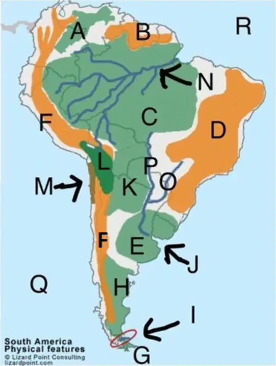
What physical feature is located at F on the map?
Answer explanation: The correct answer is the Andes Mountains. The letter F on the map is located along the western edge of South America, which is where the Andes Mountains run. The Andes are the longest continental mountain range in the world, stretching along the entire western coast of South America.
Atacama Desert
Amazon Rainforest
Andes Mountains
Patagonia
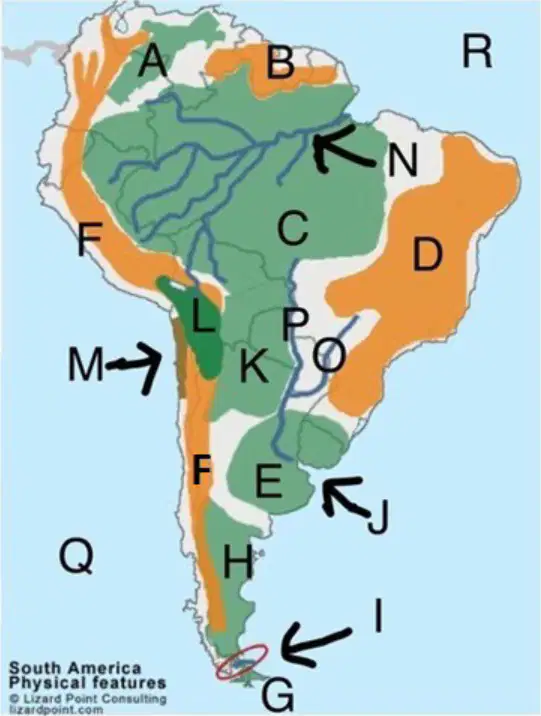
What physical feature is located at M on the map?
Andes Mountains
Amazon Rainforest
Patagonia
Atacama Desert
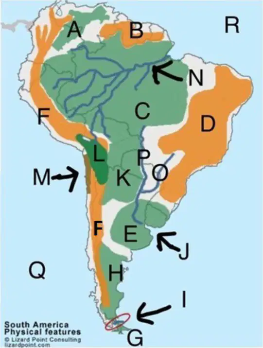
Where is the Amazon River located on the map? Choose from the letters below:
N
O
A
P
What Type Of Government Does The United States of America Have?
theocracy
oligarchy
democratic republic
Which of the following countries has both the largest territory and largest population of any country in Latin America?
Chile
Bolivia
Brazil
Argentina
Geography is the study of
the history and development of the earth
land, water, natural resources, and population flows
the distribution and interaction of Earth’s physical and human features
the measurement and physical description of places, regions, areas, and land masses
Countries with lower standards of living and primarily engaged in agricultural activities are
newly industrialized/developing
more developed
less developed
exploited
What 3 main countries make up North America?
Canada, Mexico & US
Canada, U.S. & Quebec
Greenland, US & Honduras
US, Mexico & Alaska
A ________ is a way of drawing the earth's surface that reduces distortion caused by converting three dimensions into two dimensions.
topographic map
map projection
satellite image
globe
Why did the Spanish and Portuguese bring Africans to the New World/Latin America?
to clear land
to work on the sugar plantations
to mine gold and silver
to build cities
What was the goal of the Crusades?
to trade with spice merchants in East Asia
to recapture Palestine from the Muslims
to find a cure for the bubonic plague
to recapture Byzantine from the Ottomans
Tectonic plates that move towards each other and sometimes form mountains are called
divergent
glancing
convergent
transform

What country is located at #22 on the map?
Argentina
Brazil
Cuba
Mexico
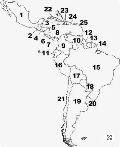
What country is located at #15 on the map?
Argentina
Brazil
Mexico
Cuba
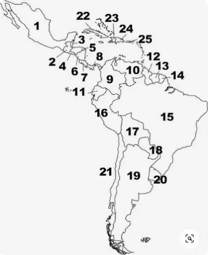
What country is located at #19 on the map?
Mexico
Cuba
Brazil
Argentina
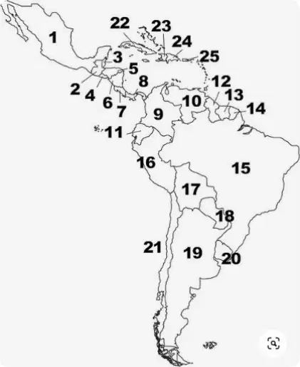
What country is located at #1 on the map?
Brazil
Cuba
Argentina
Mexico
What part of Europe is considered as a “cultural crossroads”?
Mediterranean Europe
Eastern Europe
Northern Europe
Western Europe
The total value of all goods and services produced in a country in one year is called _______
Gross National Index (GNI)
Gross National Income (GNI)
Gross Domestic Index (GDI)
Gross Domestic Product (GDP)
Climate is affected by many factors including
longitude, altitude, mountains, earth-sun, continent location, ocean & wind currents
landform, air currents, humidity, snow and sleet
ring of fire, tectonic forces, ocean depth
latitude, altitude, mountains, earth-sun, continent location, ocean & wind currents
The religion that is based on the teachings of Mohammed.
Judaism
Hinduism
Islam
Christianity
Which of the following describes the effect of the North Atlantic Drift on Europe?
It has a much milder climate than other regions at this latitude..
Russia and other parts of Europe that are far from the Atlantic have milder winters.
It has a much colder climate than other regions at this latitude.
Allows Europe to have a tropical climate along the Atlantic Ocean coast.
What is the largest tropical rainforest in the world?
Atacama
Santa Elena
Amazon
Congo
A ________ is a three-dimensional representation of the earth.
globe
thematic map
topographic map
nautical map
Where is most of the South American rainforest located?
Colombia
Uruguay
Brazil
Paraguay
Which of these landforms contributed most to the development of ethnic differences in Europe?
islands
plains
seas
mountains
Which of the following is a technique used by native peoples of Latin America to clear fields to grow crops?
terraced farming
balkanization
slash-and-burn
push-and-pull
How did the Mediterranean climate help ancient civilizations develop?
It made farming impossible
It supported stable agriculture and food supplies.
It encouraged frequent natural disasters
It forced people to migrate constantly
Magma can flow out of cracks in the earth's surface as
lava
gases
tsunami
mantle
What waterway connects the Great Lakes with the Atlantic Ocean in North America?
St. Lawrence Seaway
Rhine River
Amazon River
Mississippi River
In what type of economic system do people use the resources around them such as farm, hunt, gather things from nature and/or barter to meet their needs?
mixed economy
command economy
traditional economy
market economy
A region is categorized as being in the desert climate zone according to the
types of plants and animals that live there.
the average amount of yearly rainfall.
level of latitude and altitude.
types of landforms that exist there.
Eastern Europe was frequently invaded because of:
dense forests
deserts
wide accessible plains
mountains
A population will be most likely to grow if
its mortality rate is greater than its birthrate
its fertility rate is greater than its birthrate
its infant mortality rate is greater than its mortality rate
its birthrate is greater than its mortality rate
________ is a system that creates specialized maps from digital map information stored in a databank.
map projection
survey
Geographic Information System (GIS)
satellite
What type of economic system is there little to no government control?
market economy
mixed economy
traditional economy
command economy
In a _____, citizens vote for representatives to serve them in the central government.
theocracy
monarchy
democracy
oligarchy
A government run by religious leaders; also a very old form of government is called a _____
democracy
monarchy
oligarchy
theocracy
The bible is the holy book of what religion?
Christianity
Islam
Judaism
Hinduism
Unlike most other countries in Latin America, the main language spoken in Brazil is
English
Spanish
Dutch
Portuguese
A giant ocean wave that is sometimes caused by an earthquake is called
a high tide
an epicenter
a tsunami
a volcano
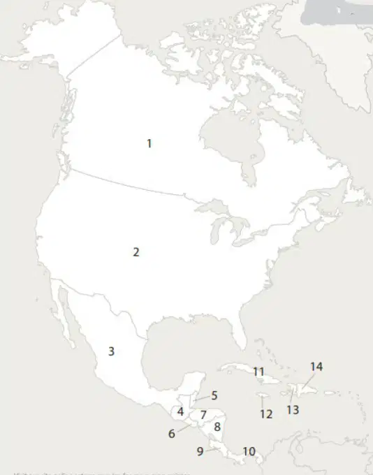
What country is located at #2 on the map?
United States
Canada
Mexico
Quebec
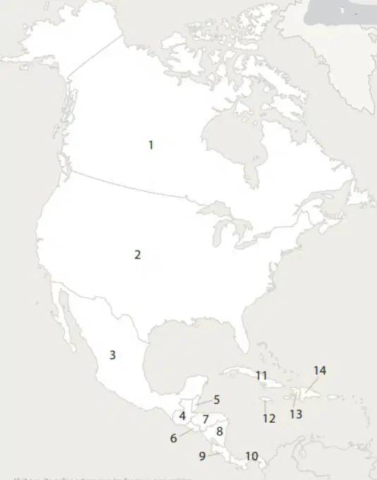
What country is located at #1 on the map?
Mexico
Canada
Quebec
United States
The main languages spoken in Canada are
English and French
Spanish and Portugese
Spanish and French
English and Spanish
Which of these was the term used for the time of renewed interest in the arts and learning between the 1300s and 1500s?
Age of Exploration
Reformation
Renaissance
Crusades
In a _____, the government determines and regulates the production of goods and services.
command economy
market economy
traditional economy
mixed economy
Countries with advanced economies and high standard of living are called
exploited
less developed
newly industrialized/developing
more developed
The Columbian Exchange map shows movements of people, commodities, and diseases between the Americas, Europe, Africa, and Asia. Which of the following is the correct definition of the Columbian Exchange?
The process of Columbus exchanging and selling food crops to natives
The process by which people, commodities, and diseases crossed the Atlantic.
The process of diseases arriving from across the ocean and wiping out the natives.
The process of transferring native plants from one place on earth to another.
When the subsoil of a region is constantly frozen, the region has
permafrost.
low humidity.
taiga.
high humidity.
Gases put up into the atmosphere cause a warming known as the greenhouse effect because
they create a barrier that traps solar energy.
the gases are warm because they come from the burning of coal and petroleum.
they create a barrier that traps carbon dioxide.
they create an environment in which vegetation thrives.
A _______ is a particular type of map that shows natural and man-made features on the earth.
map projection
globe
topographic map
survey
The longest mountains in North America are the?
Andes
Rockies
Appalachian
Alps
Tectonic plates that move past each other are called?
divergent
glancing
transform boundry
convergent
The mass murder of religious and other ethnic groups is
nationalism
Balkanization
Reformation
ethnic cleansing
What is the ancient technique used to grow crops on hillsides or mountain slopes?
push-and-pull
terraced farming
slash-and-burn
crop rotation
What Type Of Government Does The United States of America Have?
theocracy
monarchy
oligarchy
democratic republic
Which of the following would be least likely to occur in the Ring of Fire?
A an earthquake
B a volcano
C a tsunami
D a glacier
This economic activity involves the extraction of natural resources or raw materials. They include but are not limited to agriculture, fishing, mining and forestry.
quarternary
primary
secondary
tertiary
Athens developed the basis for the form of government known as _________.
democracy
feudalism
republic
monarchy
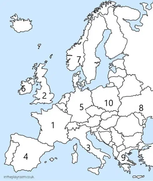
What country is located at #5 on the map?
France
United Kingdom
Spain
Germany
Italy
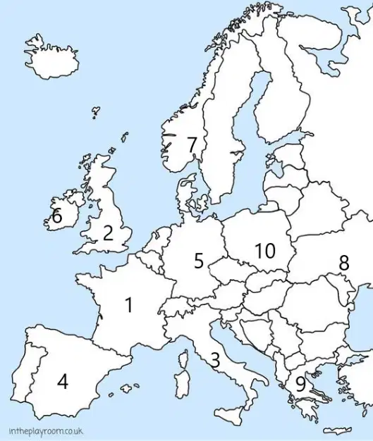
What country is located at #2 on the map?
France
Spain
Italy
United Kingdom
Germany
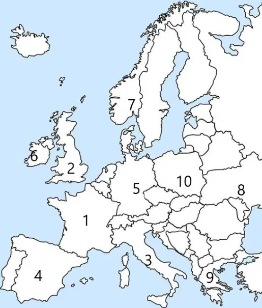
What country is located at #3 on the map?
Italy
Spain
Germany
United Kingdom
France
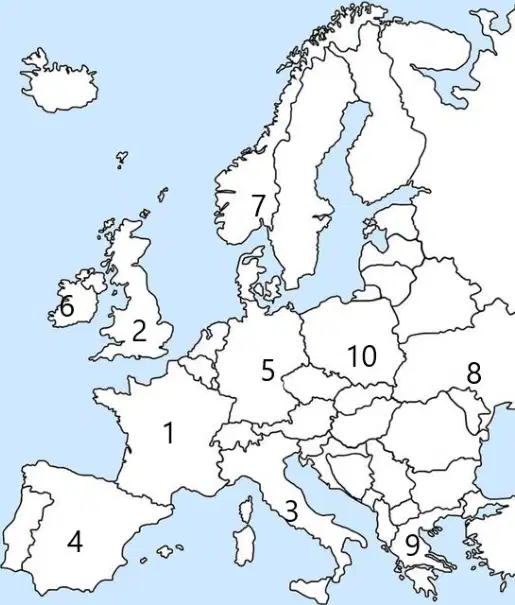
What country is located at #1 on the map?
France
Germany
Italy
Spain
United Kingdom
a set of imaginary lines that go around the earth over the poles.
latitude lines
longitude lines
hemisphere
equator
prime meridian
each half of the earth, divided either north and south or east and west.
latitude lines
longitude lines
hemisphere
equator
prime meridian
a set of imaginary lines that run parallel to the equator.
latitude lines
longitude lines
hemisphere
equator
prime meridian
an imaginary line that divides the earth into northern and southern halves.
latitude lines
longitude lines
hemisphere
equator
prime meridian
an imaginary line that divides the earth into eastern and western halves.
latitude lines
longitude lines
hemisphere
equator
prime meridian
A region's climate includes the weather conditions that occur there over a long period of time.
True
False
Indicate whether the statement is true or false: Because of earth’s revolution and its tilt, different parts of the earth receive the direct rays of the sun for more hours of the day at certain times in the year. This causes the changing seasons on the earth.
True
False
The solar equinoxes are the two times each year that the hours of day and night are equal.
True
False

