
Font size
 Worksheets
Continental Drift Practice (pages 13-16 in the note packet)
Total questions: 15
Worksheet time: 8mins
The theory of continental drift does not explain the
matching of rock features on continents thousands of kilometers apart
melting of glacial ice at the close of the Pleistocene Epoch
apparent fitting together of many continental boundaries
fossils of tropical plants in Antarctica
Which statement best supports the theory of continental drift?
A) Basaltic rock is found to be progressively younger at increasing distances from a mid-ocean ridge.
B) Marine fossils are often found in deep-well drill cores.
C) The present continents appear to fit together as pieces of a larger landmass.
D) Areas of shallow-water seas tend to accumulate sediment, which gradually sinks.

On what other landmass would you most likely find fossil remains of the late Paleozoic reptile called Mesosaurus shown below?
North America
Africa
Antarctica
Eurasia

The map below shows the present-day locations of South America and Africa. Remains of Mesosaurus, an extinct freshwater reptile, have been found in similarly aged bedrock formed from lake sediments at locations X and Y. Which statement represents the most logical conclusion to draw from this evidence?
Mesosaurus migrated across the ocean from location X to location Y.
Mesosaurus came into existence on several widely separated continents at different times.
The continents of South America and Africa were joined when Mesosaurus lived.
The present climates at locations X and Y are similar.
For the last 200 million years, continents on opposite sides of the Atlantic Ocean have generally
A) been drifting closer together
B) been drifting farther apart
C) remained the same distance apart
According to plate tectonic theory, during which geologic time interval did the continents of North America and Africa separate, resulting in the initial opening of the Atlantic Ocean? (HINT: use the "Events" column p.9 ESRTs as well as the "Era" column on p.8 ESRTs)
Mesozoic Era
Paleozoic Era
Proterozoic Eon
Archean Eon
Approximately when did these events occur?
65 million years ago
200 million years ago
299 million years ago
400 million years ago
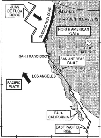
Base your answer to the following question on the map below, which shows crustal plate boundaries located along the Pacific coastline of the United States. The arrows show the general directions in which some of the plates appear to be moving slowly. The best way to find the direction of crustal movement along the San Andreas fault is to
study the Earth's present magnetic field
observe erosion along the continental coastline
measure gravitational strength on opposite sides of the fault
match displaced rock types from opposite sides of the fault
What is the direction of crustal movement of the Australian plate? (HINT: look at the ESRTs Tectonic Plate Boundaries Map (p.5) and look at ONLY the arrows INSIDE the Indian-Australian Plate and see generally which way THEY point)
northward
southward
northwestward
southeastward
During which geologic time unit were the continents of North America, South America and Africa closest together? (HINT: Use pps. 8-9 ESRTs)
Paleogene
Cretaceous
Permian
The theory of continental drift suggests that the
continents moved due to changes in the Earth's orbital velocity
continents moved due to the Coriolis effect caused by the Earth's rotation
identical present-day fossils (70 MYO) of a small freshwater lizard (mesosaurus) in S.America Africa suggest an ocean current allowed them to swim the equivalent of the current distance (1000's of KM) between those two continents
present-day continents of Antarctica and Australia share glacial scratch patterns from a single glaciation event long ago.
Which of the following best explains why this is true?
A) the climate of Antarctica was warmer because that latitude was tropical then due to a global warming pattern between periods of ice age.
B) the swamp/plant material drifted on the ocean from the warm place where it had previously been alive.
C) the pressure of compaction (that made the coal) mimicked the tropically warm conditions necessary for it to survive to then become fossilized into coal.
D) the continent Antarctica was located closer to the tropical latitude many years ago and due to mantle convection was subsequently moved to the south geographic pole.

Base your answer to the following question on the map below. The map represents the movement of tectonic plates that resulted in the collision of India with Asia. Scientists believe that 71 million years ago, India was at position A. Which present-day geologic feature in Nepal resulted from this collision?
a rift valley
a mountain range
an oceanic ridge
an oceanic trench

Which provides the best explanation of the mechanism that causes these "plates" to move across the Earth's surface?
convection currents in the mantle
faulting of the lithosphere
the spin of the Earth on its axis
prevailing wind belts of the troposphere

Base your answer to the following question on the map of the Mid-Atlantic Ridge shown below. Points A through D are locations on the ocean floor. Line XY connects locations in North America and Africa. In which cross section do the arrows best show the mechanism occurring within the asthenosphere beneath line XY that properly shows what is going on to make the type of boundary you can find between X--Y?
A) Mid-Atlantic Ridge with arrows showing upward movement.
B) Mid-Atlantic Ridge with arrows showing convergent movement.
C) Mid-Atlantic Ridge with arrows showing divergent movement.
D) Mid-Atlantic Ridge with arrows showing lateral movement.

