wayground logo

Free Printable Worksheets

NEW

Font size

S
M
L
XL
Worksheets

Earth Science Regents Meteorology

Total questions: 25

Worksheet time: 41mins

Name
Class
Date
1.
Which type of electromagnetic radiation has the shortest wavelength?
a)
ultraviolet
b)
gamma rays
c)
radio waves
d)
visible light
2.
Which weather change is most likely indicated by rapidly falling air pressure?
a)
Humidity is decreasing.
b)
Temperature is decreasing.
c)
Skies are clearing.
d)
A storm is approaching.
3.
Earth’s surface winds generally blow from regions of higher
a)
air temperature toward regions of lower air temperature
b)
air pressure toward regions of lower air pressure
c)
latitudes toward regions of lower latitudes
d)
elevations toward regions of lower elevations
4.
What is the relative humidity when the dry-bulb temperature is 16°C and the wet-bulb temperature is 14°C?
a)
90%
b)
80%
c)
14%
d)
13%
5.
A low-pressure system in the Northern Hemisphere has a surface air-circulation pattern that is
a)
clockwise and away from the center
b)
clockwise and toward the center
c)
counterclockwise and away from the center
d)
counterclockwise and toward the center
6.
Which type of air mass most likely has high humidity and high temperature?
a)
cP
b)
cT
c)
mT
d)
mP
7.
An air mass entering Alaska from the northern Pacific Ocean would most likely be labeled on a weather map as
a)
cP
b)
cT
c)
mP
d)
mT
8.
The dewpoint is 15°C. What is the wet-bulb temperature on a sling psychrometer if the dry-bulb temperature is 18°C?
a)
16°C
b)
2°C
c)
3°C
d)
20°C
9.
If the air temperature is 20°C and the relative humidity is 58%, what is the dewpoint?
a)
5°C
b)
12°C
c)
15°C
d)
38°C
10.
In which direction do the surface winds blow around a high-pressure system in the Northern Hemisphere?
a)
clockwise and inward
b)
clockwise and outward
c)
counterclockwise and inward
d)
counterclockwise and outward
11.
Clouds most likely form as a result of
a)
moist air rising, compressing, and warming
b)
moist air rising, expanding, and cooling
c)
dry air rising, compressing, and warming
d)
dry air rising, expanding, and cooling
12.
What type of storm front if this?
a)
Warm Front
b)
Cold Front
c)
Stationary Front
d)
Occluded Front
13.
What type of storm front is this?
a)
Warm Front
b)
Cold Front
c)
Occluded Front
d)
Stationary Front
14.
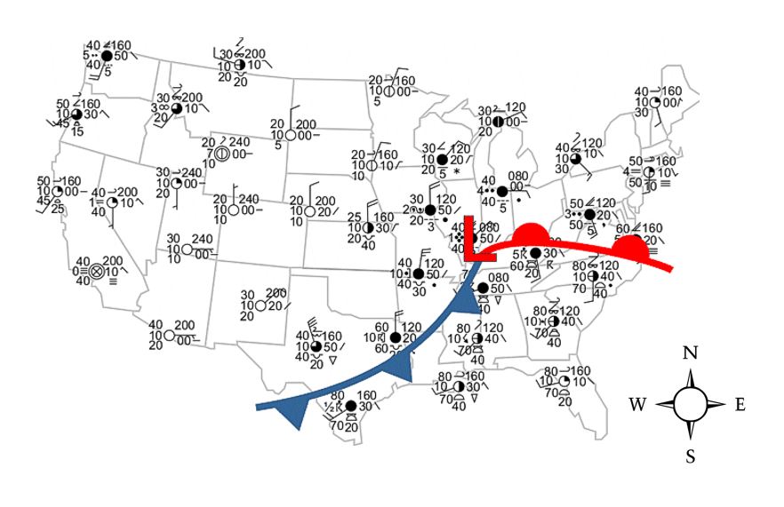
What direction is the cold front moving on the map? 
a)
Southwest
b)
Northwest
c)
Southeast
d)
Northeast
15.
What direction is the warm front moving on the map? 
a)
North
b)
South
c)
East
d)
West
16.
When two different air masses collide...
a)
A front forms
b)
They casually become one
c)
A new planet evolves
d)
Dinosaurs become extinct
17.
Where does it rain relative to the warm front?
a)
On top of the front
b)
Behind the front
c)
Ahead of the front
18.

Specific heat is used to explain why different substances

a)

sink or float in water

b)

change temperature at different rates

c)

vaporize or condense at different temperatures

d)

melt and freeze at the same temperature

19.

The block diagrams above represent two large regions on Earth’s surface. Compared to the white sandy region, the vegetative region is

a)

less humid and absorbs less insolation

b)

less humid and absorbs more insolation

c)

more humid and absorbs less insolation

d)

more humid and absorbs more insolation

20.

If the center of the low-pressure system follows a normal storm track, toward which city would the center of this low most likely move?

a)

Buffalo

b)

Elmira

c)

New York City

d)

Plattsburgh

21.

Severe weather was occurring in Elmira, New York. Which present weather symbol was most likely recorded on the station model for Elmira?

a)
b)
c)
d)
22.

Which map shows the most probable areas of precipitation that would appear on a radar image taken at the time of these frontal positions?

a)
b)
c)
d)
23.

The climate of location A is more humid than location B because A is

a)

at a lower elevation

b)

at a higher latitude

c)

on the side of a mountain range facing the prevailing wind

d)

receiving a greater amount of energy from the Sun

24.

Compared to the annual range in temperatures at location C, the annual range in temperatures at location D will be

a)

less, because D is located near a large body of water

b)

less, because D is located at a greater longitude

c)

greater, because D is located near a large body of water

d)

greater, because D is located at a greater longitude

25.

What is the relative temperature and name of the surface ocean current that affects the climate of location E?

a)

warm Alaska Current

b)

warm Gulf Stream Current

c)

cool Peru Current

d)

cool California Current