
 Worksheets
Seismographs
Total questions: 15
Worksheet time: 15mins

An instrument that records vibrations in the ground and determines the location and strength of an earthquake.
seismograph
seismogram
seismic wave
vibrato

What type of wave are the PINK waves? (orange circle is the core)
P-waves
S-waves
Love waves
Raleigh waves
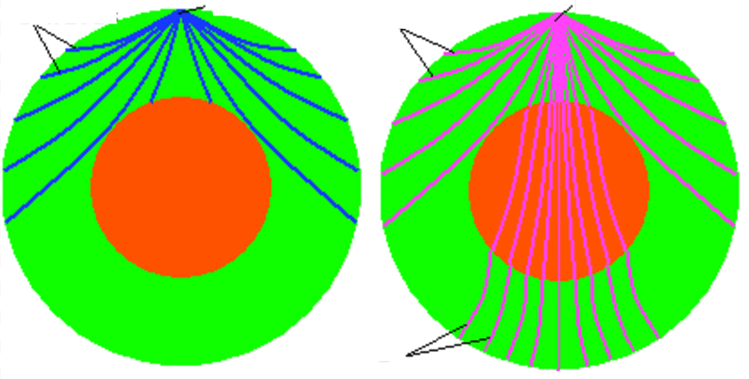
What type of wave are the BLUE waves? (orange circle is the core)
P-waves
S-waves
Love waves
Raleigh waves
Waves with ________ produce greater shaking as they pass through the ground.
smaller amplitudes
greater amplitudes
The point on Earth's surface directly above the focus.
focus
seismic waves
epicenter
amplitude
What question can scientists learn from a seismograph reading?
How deep is the earthquake?
How strong is the earthquake on the Richter Scale?
How far away will the earthquake travel?
How much damage will the earthquake cause?
The seismograph is most useful for studying earthquakes because...
it can predict the weather.
it can prevent an earthquake.
it can measure the strength of vibrations.
it can change the intensity of an earthquake.
Scientists place several seismographs along a mountain chain. Which question will the scientists MOST LIKELY answer with information they collect from the seismographs?
Where do faults occur?
How tall are the mountains?
How can earthquakes be prevented?
Which parts of the mountains are formed by volcanic eruptions?
A teacher is planning a school-sponsored trip to California. The teacher knows that there are many fault lines in California. What question might she ask to ensure it will be safe to go on the trip?
What do the most recent seismograph reports say about the vacation destination in California?
What systems are developing in the Pacific Ocean according to satellite imagery?
How do GIS maps help us understand the land in California better?
What infrared images are available to help us see when earthquakes have happened in previous years?
The magnitude of an earthquake is measured by an instrument called
a digital scale
a seismogram
a seismograph
kilogram
Seismographs are used to measure what aspect of earthquakes?
A) The color of the earthquake
B) The temperature of the earthquake
C) The magnitude of the earthquake
D) The duration of the earthquake
Which component of a seismograph is responsible for recording the seismic waves?
A) The pendulum
B) The needle
C) The base
D) The paper roll
How do seismographs help in understanding the Earth's interior?
A) By measuring the temperature of the Earth's core
B) By analyzing the speed and path of seismic waves
C) By detecting the color changes in rocks
D) By recording the sound of earthquakes
What is the primary reason for placing multiple seismographs in different locations?
A) To increase the cost of earthquake monitoring
B) To triangulate the epicenter of an earthquake
C) To measure the height of mountains
D) To predict the weather
In a seismograph, what does the amplitude of the recorded waves indicate?
A) The depth of the earthquake
B) The distance to the epicenter
C) The strength of the earthquake
D) The duration of the earthquake

