
Font size
 Worksheets
Independent Review Unit 10
Total questions: 28
Worksheet time: 27mins
Which of these events could result from days of heavy rainfall in a hilly region?
an earthquake
a tornado
a tsunami
a landslide
When a severe tropical storm forms over the ocean it can become a
Blizzard
hurricane
tornado
tsunami
Which event below is the most difficult to forecast because they often happen without warning?
Earthquake
Volcano
Hurricane
Blizzard
Which of these steps would help to reduce the chances of a mudslide occurring in a hilly region?
leaving the trees and other plant cover on the hillsides
removing all trees and plant cover from the hillsides
building fences at the bases of the hills
erecting signs that say "watch for falling rock"
when a tectonic plate moves it can produce
glaciers
earthquakes
impact craters
fossils
extreme weather events such as floods, hurricanes, and tornadoes; classified by the extent and intensity of their impact on the ecosystem
atmospheric conditions
catastrophic events
geologic forces
seismic waves
forces resulting from processes occurring within Earth’s crust
atmospheric conditions
catastrophic events
geologic forces
seismic waves
waves of energy that travel through Earth and are the result of an earthquake, volcano, or explosion
atmospheric conditions
catastrophic events
geologic forces
seismic waves
major geological event that occurs when plates shift suddenly and release stored energy; a frequent occurrence along all types of plate boundaries
earthquake
volcanic eruption
tsunami
landslide
vent in which molten rock spews out of the mantle to the surface of the earth as ash, lava, and gases
earthquake
volcanic eruption
tsunami
landslide
a giant wave usually caused by an earthquake or volcano beneath the ocean floor
earthquake
volcanic eruption
tsunami
landslide
the sudden movement of rock and soil down a slope
earthquake
volcanic eruption
tsunami
landslide
a rising body of water that submerges normally dry land
flood
hurricane
tornado
wildfire
a severe storm that develops over tropical oceans and whose strong winds of more than 120 km/h spiral in toward the intensely low-pressure storm center
flood
hurricane
tornado
wildfire
rapidly whirling, funnel-shaped cloud that reaches down to touch Earth’s surface
flood
hurricane
tornado
wildfire
a large fire that spread quickly over a natural area
flood
hurricane
tornado
wildfire
events in nature that may have a negative effect
forecast
seismic waves
natural hazard
geologic forces
Which of the following is NOT a natural hazard?
Hurricane
Tornado
House Fire
Earthquake
Geoscience Processes
Geoscience processes are natural actions that change the Earth's surface over time. These include things like erosion, weathering, earthquakes, and volcanoes. For example, rivers can slowly wear away rocks and soil, carving deep valleys or canyons. Wind can carry sand and shape deserts, while glaciers can move across land, leaving behind deep grooves and valleys.
Some geoscience processes happen slowly, over millions of years, like mountains forming or rocks breaking down into soil. Others, like earthquakes and volcanic eruptions, happen quickly and can cause big changes in just a few minutes or days.
These processes show how the Earth is always changing, even if it happens so slowly that we don’t notice it every day.
Refer to “Geoscience Processes.” How do glaciers change Earth’s surface over long periods?
By depositing large amounts of volcanic ash.
By scraping and carving valleys as they move.
By rapidly melting and flooding valleys.
By building mountains as they flow.
Geoscience Processes
Geoscience processes are natural actions that change the Earth's surface over time. These include things like erosion, weathering, earthquakes, and volcanoes. For example, rivers can slowly wear away rocks and soil, carving deep valleys or canyons. Wind can carry sand and shape deserts, while glaciers can move across land, leaving behind deep grooves and valleys.
Some geoscience processes happen slowly, over millions of years, like mountains forming or rocks breaking down into soil. Others, like earthquakes and volcanic eruptions, happen quickly and can cause big changes in just a few minutes or days.
These processes show how the Earth is always changing, even if it happens so slowly that we don’t notice it every day.
Refer to “Geoscience Processes.” Which two pieces of evidence best support how geoscience processes have changed Earth’s surface over time?
Layers of sedimentary rock showing fossils of marine life on mountain tops.
Recent damage to buildings caused by an earthquake.
U-shaped valleys found in regions previously covered by glaciers.
The rapid formation of a volcanic island after an eruption.
The consistent shape and size of continents over millions of years.
Geoscience Processes
Geoscience processes are natural actions that change the Earth's surface over time. These include things like erosion, weathering, earthquakes, and volcanoes. For example, rivers can slowly wear away rocks and soil, carving deep valleys or canyons. Wind can carry sand and shape deserts, while glaciers can move across land, leaving behind deep grooves and valleys.
Some geoscience processes happen slowly, over millions of years, like mountains forming or rocks breaking down into soil. Others, like earthquakes and volcanic eruptions, happen quickly and can cause big changes in just a few minutes or days.
These processes show how the Earth is always changing, even if it happens so slowly that we don’t notice it every day.
Refer to “Geoscience Processes.” A student observes a deep canyon with a river flowing at the bottom and sediment layers visible along the canyon walls. Select the two best statements to include in your explanation:
The canyon formed quickly due to a large earthquake.
The river gradually eroded the rock over millions of years, carving the canyon.
Sediments from the river were deposited on the canyon walls, building it over time.
The layers of sediment suggests that deposition took place over a long period of time before the canyon formed.
The canyon walls were formed by the river pushing the rock upward over a long period of time.
Predicting Natural Disasters
The best way to predict or tell when natural disasters will occur is to study ones that have already happened. This gives scientists important information about the events that lead up to disasters. It also helps the scientists understand the forces of nature that cause the disasters.
Scientists have developed a good understanding of the factors that lead to hurricanes, tornadoes, and flooding. Predicting events such as earthquakes and volcanic eruptions, however, is much more difficult. Volcanoes may give warning signs, such as leaking gases or spouting lava, before erupting, but sometimes they erupt with no warning at all.
Earthquakes are also difficult to predict. However, scientists are aware of the regions in the world where earthquakes are most likely to occur. In these places they use equipment to monitor any changes that might suggest an earthquake is about to happen.
Refer to “Predicting Natural Disasters”. Which of the following best describes the relationship between earthquake and volcano locations?
They are more concentrated in areas with mountains
They occur randomly all over the Earth’s surface
They are more concentrated along tectonic plate boundaries
They occur more frequently in the Southern Hemisphere

According to the visual, Ring of Fire, what pattern is most noticeable in the distribution of earthquakes and volcanoes in the Pacific Ring of Fire?
They are evenly spaced throughout all continents
The are concentrated near Earth’s equator
They are randomly distributed across the ocean floor
They form a circular pattern around the Pacific Ocean

This map shows tornado activity in the United States between 1950 and 1998.
Based on the data provided by this map, which of the following cities would be most likely to experience a tornado with a rating of F3 or greater in the next year?
Phoenix, Arizona
Topeka, Kansas
Orlanda, Florida
Columbia, South Carolina
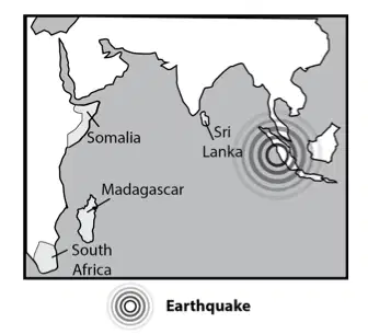
The provided map shows the location of an earthquake under the ocean.
The data on the map would best support a prediction of which of the following events?
A tsunami in Sri Lanka
An earthquake in South Africa
A hurricane in Somalia
Flash floods in Madagascar
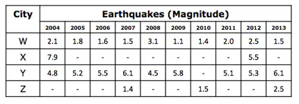
The table provides data on the earthquakes recorded for four different cities over a ten year period.
Assuming the data indicates patterns that will continue, which city will most likely experience an earthquake of a magnitude of 5.0 or higher in the next year or two?
City W
City X
City Y
City Z
Which of these measures can help mitigate the impact of earthquakes in urban areas?
Increasing the number of streetlights
Installing more traffic signals
Planting more trees
Building structures with flexible materials

