
 Worksheets
Weather Permitting Climate
Total questions: 88
Worksheet time: 1hrs 1mins

A cold front is approaching Minneapolis. What will happen to the air temperature?
stay the same
increase
decrease
A __________ is the lines between air masses.
low pressure system
high pressure system
front
True or False: Changes in wind speed and direction can indicate a storm or change of temperature
True
False
The Earth's ____________ is the layer of gases that surround the planet and make it possible for living things to survive on Earth.
atmosphere
water cycle
shell
land
Water Vapor rises from the Earth's surface during this phase of the water cycle.
Condensation
Evaporation
Precipitation
Run Off
Clouds form during this phase of the water cycle because water vapor cools and changes back to water droplets.
Evaporation
Precipitation
Condensation
Run Off
Evaporation is caused by
the sun cooling
the sun's heat energy
the moons heat energy
the moon cooling
The amount of precipitation in an area is measured and collected by which weather tool?
Anemometer
Rain Gauge
Wind Vane
Barometer
A warm front means the air temperature will
stay the same
increase
decrease
A scientist who measures and predicts weather conditions is known as
an astronomer
a geologist
a meterologist
a weatherologist
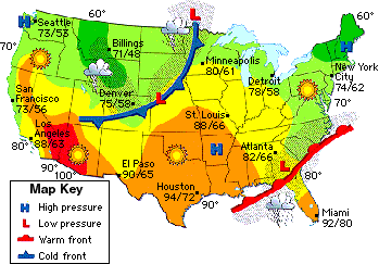
A low pressure system is located over Georgia. What type of weather will they have?
clear, sunny skies
cloudy and rainy
A high pressure system is located north of New York City. What type of weather will be experienced there?
clear, sunny skies
cloudy and rainy
This weather tool will help measure temperature degrees in Fahrenheit and Celsius
Anemometer
Thermometer
Weather Vane
Barometer
Which statement best describe the importance of making weather predictions?
not important at all
somewhat important because they are always accurate information
important because they can provide possible warnings to people

How many tornadoes have hit the states of IA and MS combined from 1950-2011?
80
50
30
160
Mountain climates are usually wetter and windier than lowland regions.
True
False
On mountains, temperature _____________ with altitude(height)
increases
decreases

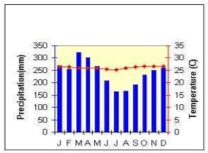
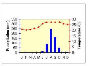
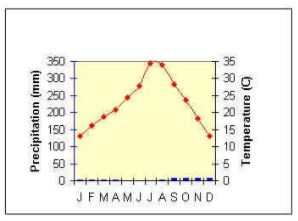
Identify the climate
polar
tropical
temperate

Identify the climate
polar
tropical
temperate

Identify the climate
polar
tropical
temperate
Areas near the Earth's poles are typically
hot
cold
Landmasses near the equator are typically
hot
cold
Climate is the long-term weather of an area
(at least 30 years)
True
False
The worldwide system of ______________, which transports warm and cold air very great distances, significantly influences the climates of the world.
oceans
rivers
clouds
winds
Hot and dry year-round, usually receives less than 10 inches of rainfall a year.
mountain
desert
grassland
temperate forest
If a factory were built on the mountain and chemicals leaked outside on the ground, what part of the water cycle will contribute to water pollution
Evaporation
Runoff
Precipitation
Transpiration
In which of the following locations would hurricanes occur?
The Arctic
The Rocky Mountains
The Gulf of Mexico
The Rainforest
Which of the following graphs correctly shows the makeup of gasses in the atmosphere?


What aspect of the water cycle is being graphed here?
Evaporation
Condensation
Precipitation
Transpiration
The Coriolis Effect is caused by
Earth rotating around the sun
Earth rotating on its axis
The tides
Gravity
The Gulf stream carries _____________ water from the east coast of The United States to the West coast of Europe.
Cold
Warm
Freezing
Fresh
What happens to a current when it comes in contact with a continent or landmass?
It continues over the continent
It stops
It changes direction
It is absorbed by the land
Warm ocean currents generally come from
The North Pole
The South Pole
The Equator
Both A and B
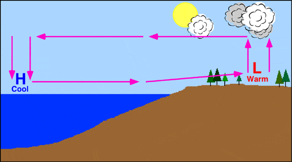
A low pressure system means we might have this weather.
Sunny
A clear sky
Dry day
Stormy or wet
An air current in the upper atmosphere that flows from west.
current
jet stream
gulf stream
polar air flow
A flow of air or water in a certain direction.
air flow
jet stream
current
el nino
Hot and dry; Mexico and southwestern USA; only impacts during the summer
continental tropical air masses
la nina
tropical air flow
continental Arctic air
Warm ocean current in the Atlantic Ocean.
jet stream
continental tropical air masses
gulf stream
warm front
Cold, dry and stable weather. Forms over Alaska and Canada. Great Lakes get lake effect snow.
gulf stream
jet stream
continental Arctic air
continental polar air mass
Warm phase; high air pressure; forms over the Pacific Ocean
maritime tropical air
la nina
gulf stream
el nino
Air current in the upper atmosphere that flows from west to east.
jet stream
gulf stream
current
air flow
Cold and dry; forms farther north than Alaska and Canada; usually only in winter
continental polar air mass
continental tropical air masses
continental Arctic air
current
Warm and very humid; unstable
el nino
la nina
gulf stream
maritime tropical air
Cool phase over the Pacific Ocean
continental tropical air mass
el nino
la nina
gulf stream
Which city would you expect to have the overall colder climate?
Atlanta, Georgia (elevation of 1,050 feet)
Baton Rouge, Louisiana (elevation of 56 feet)
Chicago, Illinois (elevation of 579 feet)
Steamboat Springs, Colorado (6, 732 feet)
The temperature and humidity of a swamp is:
very warm during the summer and the higher humidity during the warmer seasons
very cool during the summer and the humidity is low during the warmer seasons
very warm all year long with very little humidity
very cold all year long with little humidity
The climate of a particular region is NOT affected by:
latitude
minerals
nearby water
elevation
Which factor does NOT affect the kind of climate an area has?
distance from the equator (latitude)
elevation
proximity to bodies of water
wind direction
What climate zone is located near the equator where the sun is directly overhead all year?
polar
tropical
desert
temperate
What are the three main climate zones?
tropical, thermal, polar
tropical, temperate, polar
cold, super hot, blah
polar, tropical, humid
Areas closer to the equator receive more direct energy from the Sun and have warmer temperatures.
True
False
The higher the elevation of an area, the _______ the climate.
warmer
cooler
Most of the United States is in Earth's ___________ climate zone.
polar
tropical
temperate
subtropical

What causes seasons to change?
Earth's rotation
Earth's tilt
Hot and Cold
Magic
What is climate?
weather
rain, sleet, snow, or hail
average weather in a region over a long period of time
the amount of ice cream available in a city
The driving force of the Water Cycle is?
The troposphere
The Sun
The oxygen
The clouds
The Coriolis Effect is caused by what?
The wind blowing
Earth's gravity pulling things down
The rotation of the Earth
The pull of the Moon
A polar air mass will have what kind of air in it?
Warm
Cold
Humid
Dry
The Coriolis effect causes ___________.
the Earth to rotate on its axis
earthquakes
global winds to move in a curved path instead of a straight line
the Earth to revolve around the sun


This photo represents a ______ climate
Tropical
Polar
Temperate




In 2017, which locations were the top two producers of CO2 emissions?
China
United States
Asia Pacific
Middle East

Which two states had the highest cost related to climate change disasters?
Florida
Texas
California
Kentucky
Hawaii

