
 Worksheets
Chapters 4-1 and 4-2 Student Unit Grown
Total questions: 20
Worksheet time: 10mins
Name
Class
Date
1.
Maps are typically aligned to?
a)
Equatorial north
b)
True north
c)
Magnetic north
d)
Stellar north
2.
What features does a planimetric map omit?
a)
Lines of communication
b)
Town and city names
c)
Terrain and landforms
d)
Political boundaries
3.
Elevations and contours are normally measured from?
a)
Sea level
b)
Mean altitude
c)
Geographic reference altitude
d)
Ground level
4.
Topographic maps portray what?
a)
Terrain and landforms as contours
b)
Population estimates
c)
Tropical subareas
d)
Political boundaries
5.
Which of these is not a map coordinate system?
a)
UTM
b)
Geographic Coordinate System
c)
GEOREF
d)
GMT
6.
Meridians of longitude are oriented how?
a)
Parallel to the magnetic poles
b)
Parallel to the Equator
c)
North-south to the true poles
d)
East-west
7.
The Prime Meridian has what value of Longitude?
a)
90 degrees
b)
180 degrees
c)
270 degrees
d)
0 degrees
8.
The Prime Meridian runs through where?
a)
Washington DC, USA
b)
Berlin, Germany
c)
Reykjavik, Iceland
d)
Greenwich, England
9.
The difference between true and magnetic poles is called?
a)
Magnetic correction
b)
True difference angle
c)
True variation
d)
Magnetic variation
10.
The Equator is what degrees of Latitude?
a)
90 degrees
b)
0 degrees
c)
270 degrees
d)
180 degrees
11.
The North pole is what degrees of Latitude
a)
90 degrees
b)
0 degrees
c)
270 degrees
d)
180 degrees
12.
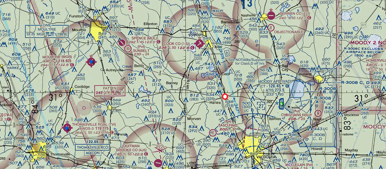
What are the approximate coordinates of Hahira (red circle) in the map below?
a)
3059S 08322E
b)
3059W 08322N
c)
3059N 08322W
d)
3059N 08322E
13.
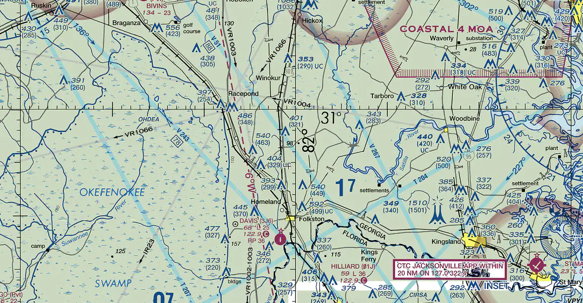
To walk due East on the area depicted in the map below what magnetic heading is needed on a compass?
a)
264 degrees
b)
084 degrees
c)
276 degrees
d)
096 degrees
14.
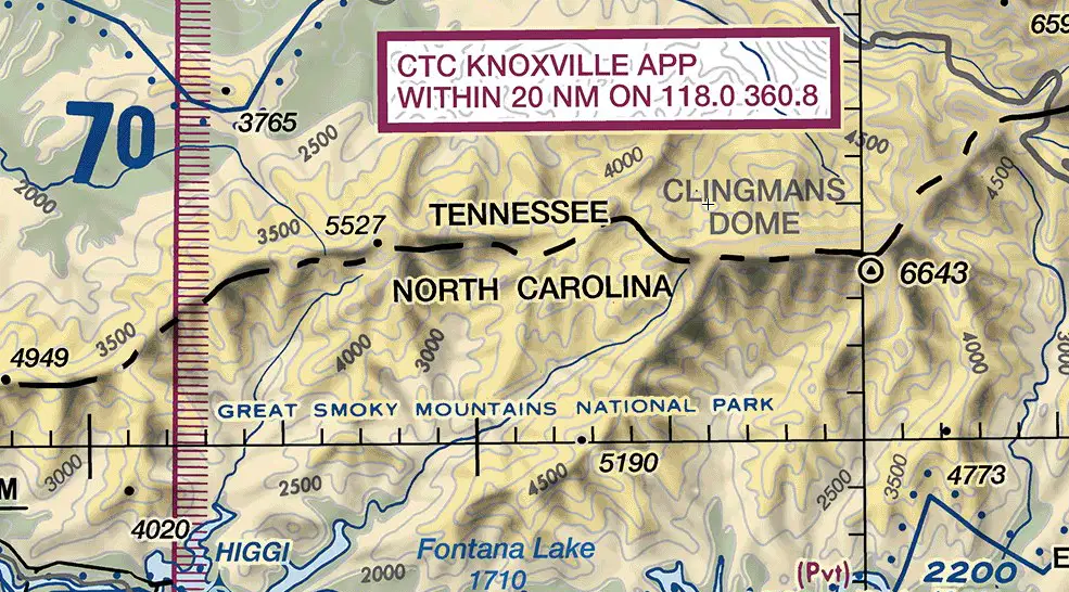
The border between Tennessee and North Carolina in the area of the map below can best be described as a?
a)
Valley
b)
Saddle
c)
Ridge Line
d)
Canyon
15.
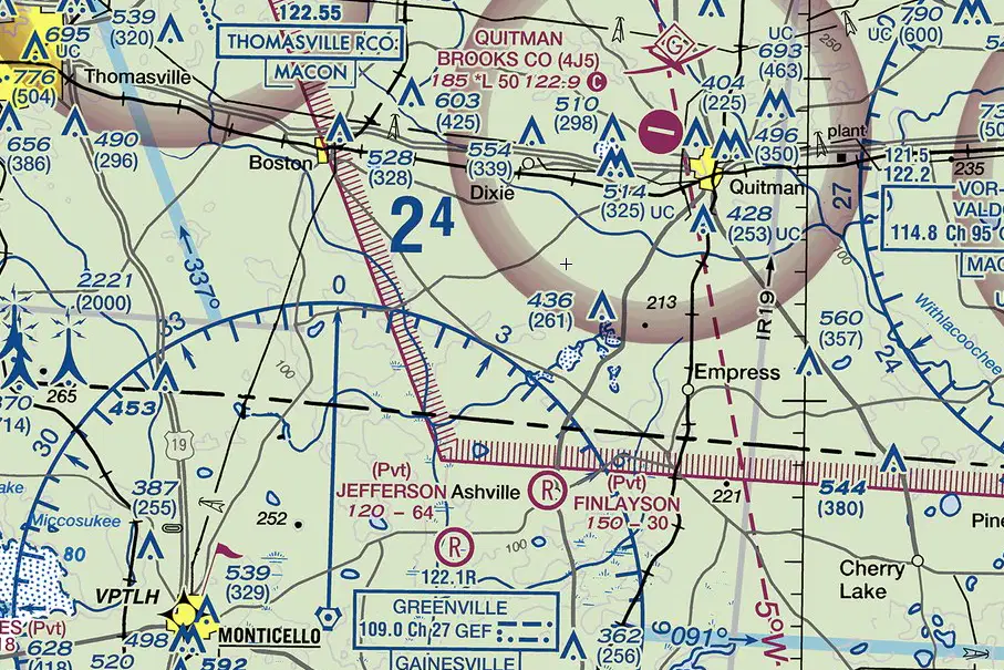
In the map below what is the approximate magnetic heading and distance from Dixie to Boston?
a)
095 degrees for 12 nautical miles
b)
275 degrees for 6 nautical miles
c)
090 degrees for 6 nautical miles
d)
270 degrees for 12 nautical miles
16.
What are two methods to use the sun for determining direction?
a)
Watch and shadow-tip methods
b)
Polar observation and watch methods
c)
Shadow-tip and sundial methods
d)
Sundial and watch methods
17.
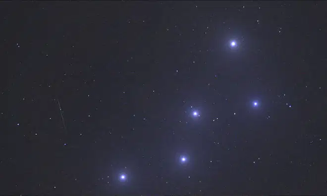
Identify the constellation below
a)
Little Dipper
b)
Ursa Major
c)
Ursa Minor
d)
Cassiopeia
18.
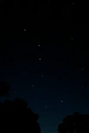
Identify the constellation Below
a)
Ursa Minor
b)
Little Dipper
c)
Orion's Belt
d)
Ursa Major
19.
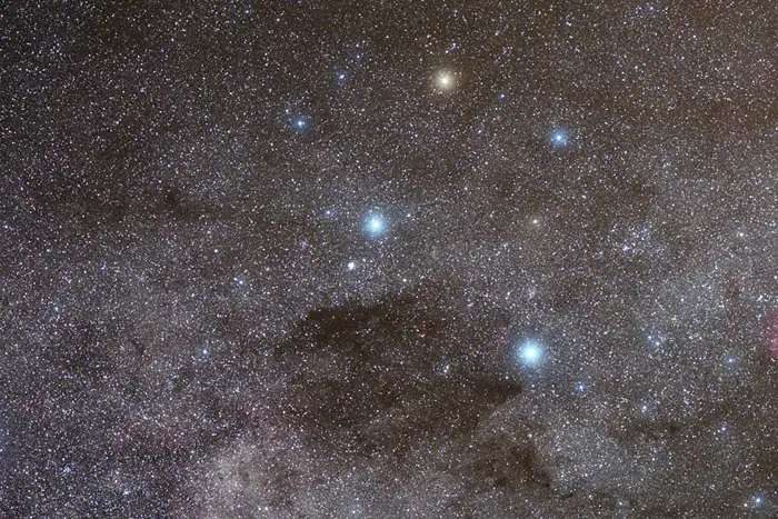
Identify the constellation below
a)
Alpha centaury
b)
Orion's Belt
c)
Ursa Minor
d)
Southern Cross
20.
In the northern hemisphere tree growth is more lush where?
a)
North side
b)
East side
c)
South side
d)
West side
100 %

