
NEW
Font size
 Worksheets
4/10: Quizizz: Station models, Fronts, Air masses, & Winds belt
Total questions: 40
Worksheet time: 2hrs 53mins

Which Front will create Heavy Rain, Thunder Storms and Severe Weather?
Cold Front
Warm Front
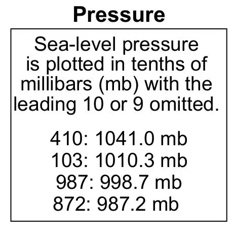
How can we convert the coded sea-level air pressures of 500 and UP+ on a station model?
Add a 9 in the front and a decimal point before the last number
Add a 10 in the front and a decimal point before the last number
Add a 5 in the front and a decimal point before the last number
Add a 7 and a decimal point after the last number
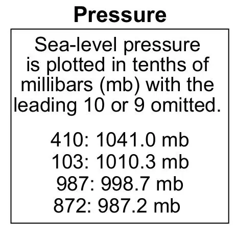
How can we convert the coded sea-level air pressures of LESS than 500 on a station model?
Add a 9 in the front and a decimal point before the last number
Add a 10 in the front and a decimal point before the last number
Add a 5 in the front and a decimal point before the last number
Add a 7 and a decimal point after the last number
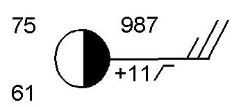
What is the actual barometric pressure for the following station model?
** Convert the Coded pressure to its ORIGINAL form.
987 mb
998.7 mb
1098.7 mb
1098 mb
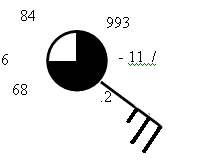
What is the amount of cloud cover for the following station model?
1/4 = 25%
1/2 = 50%
3/4 = 75%
1/10 = 10%
Wind always blows from
High temperature to low temperature
Low Pressure to High Pressure
High humidity to low humidity
High Pressure to Low Pressure
Around a LOW pressure center, winds will blow...
Clockwise and toward the center (inwards)
Clockwise and away from the center (outwards)
Counterclockwise and toward the center (inwards)
Counterclockwise and away from the center (outwards)
Around a HIGH pressure center, winds will blow...
Clockwise and toward the center (inwards)
Clockwise and away from the center (outwards)
Counterclockwise and toward the center (inwards)
Counterclockwise and away from the center (outwards)
Which station model shows an air temperature of 75°F and an air pressure of 996.3 mb?
*In order to answer this correctly look at the reference table to see where temperature is located on a station model. You will also have to make sure that the the air pressure is coded properly


Which map best represents the surface wind pattern around Northern Hemisphere high-pressure and low-pressure centers?


100 percent cloud cover and a close air temperature and dew point
Which station model shows the correct form for indicating a northwest wind at 25 knots and an air pressure of 1023.7 mb?


What is the barometric trend?
13 mb decrease in the past 3 hours
1.3 mb decrease in past 3 hours
1.3 mb increase in the past 3 hours
13 mb increase in the past 3 hours
.13 mb decrease in the past 3 hours

What is the sea level air pressure on this station model?
100.02 mb
100.2 mb
900.2 mb
1000.2 mb
002
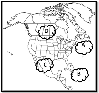
Which type of air mass brings WARM and DRY weather?
Maritime Polar (mP)
Maritime Tropical (mT)
Continental Polar (cP)
Continental Tropical (cT)
Which type of air mass brings WARM and WET weather?
Maritime Polar (mP)
Maritime Tropical (mT)
Continental Polar (cP)
Continental Tropical (cT)
Which type of air mass bring COLD and WET weather?
Maritime Polar (mP)
Maritime Tropical (mT)
Continental Polar (cP)
Continental Tropical (cT)
Which type of air mass bring COLD and DRY weather?
Maritime Polar (mP)
Maritime Tropical (mT)
Continental Polar (cP)
Continental Tropical (cT)
What type of weather would you expect in high pressure?
sunny clear skies, cool, dry air
foggy skies, light rain, moist, cold air
sunny skies, humid, warm air
cloudy skies, warm, moist air
What is the relationship is correct between air pressure and the weather?
A rise in air pressure indicates stormy weather.
A drop (fall) in air pressure indicates stormy weather.
A drop (fall) in air pressure indicates cold weather.
A rise in air pressure indicates warm weather.

Which cross section best represents a warm front?
Diagram A
Diagram B
Diagram C
Diagram D
Which geographic region is the most common source region for the mT air masses that move into New York State?
northern Canada
Gulf of Mexico
Arctic Ocean
southwestern United States
Compared to a Continental tropical air mass, a maritime polar air mass has a...
higher temperature and more water vapor
higher temperature and less water vapor
lower temperature and more water vapor
lower temperature and less water vapor

The three diagrams below represent three frontal boundaries with the surface locations of the fronts labeled A, B, and C. Arrows indicate direction of air movement. Which table correctly matches each letter with the type of frontal boundary it represents?

Diagram A

Diagram B

Diagram C

Diagram D

The map below shows surface air temperatures, in degrees Fahrenheit, reported by weather stations in the north-central United States. Letter X represents an air mass moving in the direction shown by the arrow. A line marks a frontal boundary advancing in a southeasterly direction. Which weather-map symbols best represent air-mass X and the frontal boundary shown on the map?
(HINT: Think about where the air mass "X" is coming from)?

cP

mP

cT

mT

The diagram below represents a cross section of air masses and frontal surfaces along line AB, which is an occluded front along a LOW PRESSURE SYSTEM. The dashed lines represent precipitation. Which weather map best represents this frontal system?

A

B

C

D
What two letter air mass symbols are found across the occluded front that is forming from A to B?
(REMEMBER that lower case letter c or m are written 1st and then UPPER CASE LETTERS T OR P are written 2nd)

C

D


The weather map below shows a portion of a low-pressure system. Which front will most likely pass over location A during the next two hours?
(HINT: What front will reach location A next? )
warm
stationary
occluded
cold

Air at Low Pressure areas will...
Sink and Converge
Sink and Diverge
Rise and Diverge
Rise and Converge
Air at High Pressure areas will...
Sink and Converge
Sink and Diverge
Rise and Diverge
Rise and Converge

Which cell is responsible for the rising air at the equator?
Polar cell
Ferrel cell
Hadley cell
Subtropical cell
Coriolis Effect
bands of high and low pressure found about every 30 degrees of latitude
the curving of a path of a moving object from an otherwise straight path due to Earths rotation
winds that blow from east to west between 60 and 90 degrees latitude in both hemispheres
narrow belts of strong winds that blow in the upper troposphere
Where can you find a rainforest?
30°N
30°S
90°S
0°
Which explains what happens when a cold front meets a warm front?
The cold air rises over the warm air, forming clouds followed by rain.
The cold air pushes the warm air down to the ground, forming clouds followed by rain.
The cold air pushes under the warm air, forming clouds followed by rain.
The cold air rises and evenly mixes with the warm air, forming clouds followed by rain.

Which map shows the regions that are most likely experiencing the precipitation associated with this weather system?


The L on the map represents the center of the low-pressure system. Two fronts extend from the center of the low, and are labeled front 1 and front 2. Cloud cover has been omitted from the station models. Which map best represents the type of fronts and direction of movement of these fronts in relation to the low-pressure center?
**The Fronts Must be Facing the the proper direction (TOWARDS the East)

A

B

C

D

