wayground logo

Free Printable Worksheets

Font size

S
M
L
XL
Worksheets

South and Southeast Asia Unit Review

Total questions: 40

Worksheet time: 20mins
Name
Class
Date
1.
Which South Asian country is known for its Gross National Happiness index?
a)
a. Nepal
b)
b. Bhutan
c)
c. Bangladesh
d)
d. India
2.
Which South Asian island nation is most threatened by rising sea levels?
a)
a. Sri Lanka
b)
b. The Maldives
c)
c. Nepal
d)
d. Bangladesh
3.
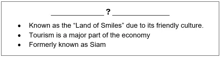
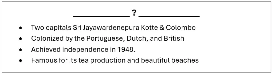
What country is described in the box?
a)
a. The Maldives
b)
b. Bangladesh
c)
c. Pakistan
d)
d. Sri Lanka
4.
Which river was home to ancient civilizations and remains crucial for agriculture in Pakistan?
a)
a. Ganges
b)
b. Mekong
c)
c. Indus
d)
d. Brahmaputra
5.
What major body of water lies between India, Bangladesh, and Myanmar?
a)
a. Arabian Sea
b)
b. Bay of Bengal
c)
c. South China Sea
d)
d. Andaman Sea
6.
The _______ desert spans parts of India and Pakistan and is known for being one of the most populated deserts in the world.
a)
a. Thar
b)
b. Gobi
c)
c. Sahara
d)
d. Kalahari
7.
Which Southeast Asian country has the world’s largest Muslim population?
a)
a. Brunei
b)
b. Indonesia
c)
c. Malaysia
d)
d. Philippines
8.
___________ is famous for being the only Southeast Asian country never colonized by a European power.
a)
a. Cambodia
b)
b. Laos
c)
c. Thailand
d)
d. Vietnam
9.
Which Southeast Asian country is a city-state and a global financial hub?
a)
a. Singapore
b)
b. Brunei
c)
c. Malaysia
d)
d. East Timor
10.
The ________ River is a major feature of Myanmar and flows into the Andaman Sea.
a)
a. Mekong River
b)
b. Ganges River
c)
c. Irrawaddy River
d)
d. Brahmaputra River
11.
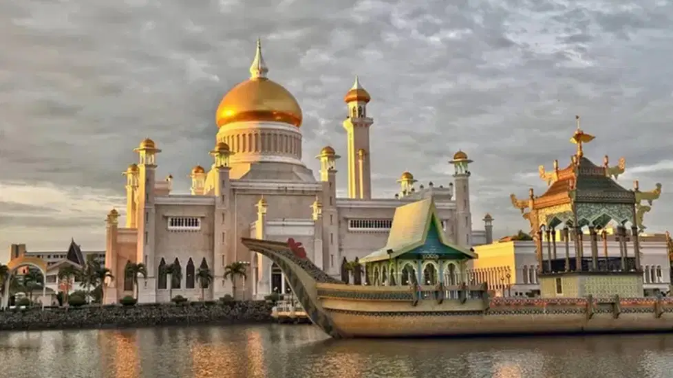
Seen here is Istana Nurul Iman, the biggest residential palace in the world belonging to the -
a)
a. King of Thailand
b)
b. Sultan of Brunei
c)
c. Government of Singapore
d)
d. Emperor of Myanmar
12.
Which country in Southeast Asia has a significant influence from both Spanish and American cultures?
a)
a. Thailand
b)
b. Vietnam
c)
c. The Philippines
d)
d. Malaysia
13.
The ______________ dramatically changes size between the wet and dry seasons, providing fish for local population.
a)
a. Tonlé Sap
b)
b. Lake Toba
c)
c. Inle Lake
d)
d. Laguna de Bay
14.
Nusantara is a “mega project” to build an entire new capital city for -
a)
a. Malaysia
b)
b. Singapore
c)
c. East Timor
d)
d. Indonesia
15.
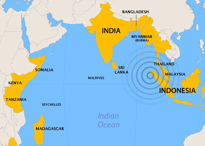
This map shows the epicenter and countries impacted by the –
a)
a. 1883 Krakatoa eruption.
b)
b. 2004 Indian Ocean Tsunami
c)
c. 2014 Bangladesh Oil Spill
d)
d. 1970 The Bhola Cyclone
16.
What country is described in the box?
a)
a. Malaysia
b)
b. Vietnam
c)
c. Cambodia
d)
d. Thailand
17.
Describe two key geographic features of South Asia and explain how they have influenced the region’s history and development.
4 lines
18.
Select one Southeast Asian country and explain how European colonization impacted it.
4 lines
19.
Explain the immediate and long-term effects of the Partition of India.
4 lines
20.
Explain the impact of monsoon seasons on the climate and economy of Southeast Asia. How do they influence agriculture and trade?
4 lines
21.
Why is the Mekong River so important to the countries it flows through, and what are some of the challenges it faces today?
4 lines
22.

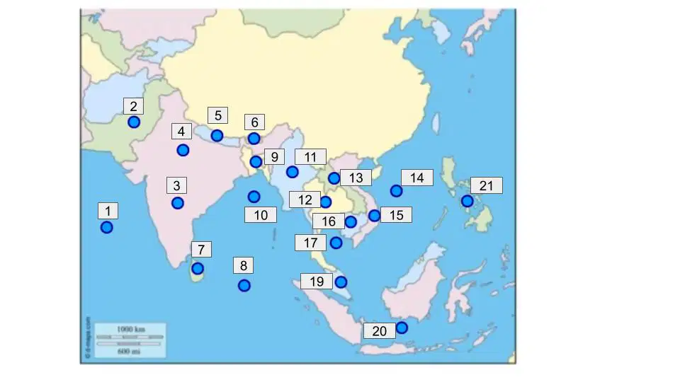
What body of water is labeled #1?

a)

Arabian Sea

b)

Indian Ocean

c)

Atlantic Ocean

d)

South China Sea

23.

What country is labeled #2?

a)

Pakistan

b)

India

c)

Nepal

d)

Bangladesh

24.

What country is labeled #4?

a)

Pakistan

b)

India

c)

Nepal

d)

Bangladesh

25.

What country is labeled #9?

a)

Pakistan

b)

Burma

c)

Nepal

d)

Bangladesh

26.

What country is labeled #11?

a)

Pakistan

b)

Myanmar

c)

Nepal

d)

Bangladesh

27.

What country is labeled #6?

a)

Pakistan

b)

Bhutan

c)

Nepal

d)

Bangladesh

28.

What country is labeled #7?

a)

Sri Lanka

b)

Bhutan

c)

Vietnam

d)

Cambodia

29.

What country is labeled #16?

a)

Laos

b)

Bhutan

c)

Vietnam

d)

Cambodia

30.

What country is labeled #19?

a)

Laos

b)

Malaysia

c)

Vietnam

d)

Cambodia

31.

What country is labeled #21?

a)

Sri Lanka

b)

Malaysia

c)

Vietnam

d)

Philippines

32.

What country is labeled #20

a)

Indonesia

b)

Malaysia

c)

Vietnam

d)

Cambodia

33.

What country is labeled #12?

a)

Laos

b)

Thailand

c)

Vietnam

d)

Cambodia

34.

What country is labeled #13?

a)

Laos

b)

Bhutan

c)

Vietnam

d)

Cambodia

35.

What country is labeled #15?

a)

Sri Lanka

b)

Bhutan

c)

Vietnam

d)

Cambodia

36.

What body of water is labeled #8?

a)

Arabian Sea

b)

Indian Ocean

c)

Atlantic Ocean

d)

South China Sea

37.

What country is labeled #5?

a)

Bangladesh

b)

Burma

c)

Pakistan

d)

Nepal

38.

What body of water is labeled #10?

a)

Bay of Thailand

b)

Indian Ocean

c)

Bay of Bengals

d)

South China Sea

39.

What body of water is labeled #17?

a)

Gulf of Thailand

b)

Indian Ocean

c)

Bay of Bengals

d)

South China Sea

40.

What body of water is labeled #14?

a)

Bay of Thailand

b)

Indian Ocean

c)

Bay of Bengals

d)

South China Sea