
 Worksheets
Geography Grade 11 Mock
Total questions: 136
Worksheet time: 3hrs 59mins
The idea that explained how continents moved over time
Continental Drift
Pangea
Plate Tectonics Theory
Plate Boundaries
A German scientist who first had the idea of continental drift.
Albert Einstein
Galileo
Alfred Wegener
Gladys West
The name of the supercontinent before they moved to where the continents are today.
Continental Drift
Pangea
Super Country
United States of America
The year Wegener first had the idea for continental drift
1975
1950
1888
1912
The decade when other scientists started believing Wegener
1940's
1950's
1960's
1970's
The scientific theory that describes how the Earth’s crust (and upper mantle) is divided into plates that can move (very slowly).
Continental Drift
Pangea
Plate Tectonics Theory
Plate Boundaries
The places where tectonic plates (big pieces of crust) meet together
Continental Drift
Pangea
Plate Tectonics Theory
Plate Boundaries
The tectonic plates move apart
Convergent Boundary
Divergent Boundary
Transform Boundary
Personal Boundary
The tectonic plates move together
Convergent Boundary
Divergent Boundary
Transform Boundary
Personal Boundary
The tectonic plates slide past.
Convergent Boundary
Divergent Boundary
Transform Boundary
Personal Boundary


Plates move apart at _________ boundaries.
volcanic
divergent
convergent
transform
Rocky or rigid outer part of Earth consisting of the brittle crust and the top part of the upper mantle
Lithosphere
Oceanic Crust
Continental Crust
Asthenosphere
Mantle convection is the very slow creeping motion of Earth’s solid silicate mantle caused by convection currents carrying heat from the interior to the planet's surface.
Lithosphere
Earthquake
Convection Currents
Core
Solid, outer layer and is made of both the oceanic and continental crust.
Hydrosphere
Core
Mantle
Crust
Hot fluid or semi-fluid material below or within the earth's crust from which lava and other igneous rock is formed on cooling.
Convection Current
Lithosphere
Core
Magma
The thick part of the earth's crust that forms the large landmasses. It is generally older and more complex than the oceanic crust.
Oceanic Crust
Continental Crust
Magma
Inner Core
In the region where two continental plates collide, what geological feature MOST often forms?
an ocean
a volcano
a river valley
a mountain chain
Crustal plates that pull apart from one another MOST likely form
volcanic island arcs
strike-slip faults
oceanic trenches
rift zones
Which two plates collided with each other to form the Himalayan Mountains?
Nazca and Eurasia
Indo-Australian and Eurasian
North America and Antarctic
South American and Indo-Australian
Which of these tectonic plate boundaries is most likely to form a volcano.
a continental plate colliding with a continental plate
an oceanic plate sliding past a continental plate
a continental plate sliding past a continental plate
an oceanic plate colliding into a continental plate
What causes the tectonic plates to continually to move?
Convection currents
Volcanic and seismic activity
Strong winds and storms
Rotation of the solid core
Which statement best describes why fossils of the same land-dwelling species have been discovered in both South America and Africa?
The organism migrated to two continents
The organisms were separated by the formation of new mountain ranges
The organisms became extinct due to climate change on these continents
These organisms once lived on one large landmass that later split into two continents
A satellite image can help scientist locate the area where two plates have diverged by showing the existence of
Plateaus
Mountains
Rift Valleys
Grassy Plains


Identify the type of fault
normal fault
reverse fault
strike-slip fault


This type of fault is....
normal fault
reverse fault
strike-slip fault


What part of an earthquake occurs underground?
Focus
Epicenter
P Waves
S Waves

The epicenter of an earthquake is the...
area on the surface directly above the breaking point
where a rock under stress breaks
seismic waves that carry energy across the crust
the shaking of the ground caused by sudden movement of rock
The three types of stress that leads to faults include:
tension, compression, and normal stress
tension, compression, and shearing stress
deformation, tension, and shearing stress


Group of islands
Lake
Atoll
Archipelago
Plateau
Valley
Area of land drained by a given river and its branches
Lake
Ocean
Plateau
Basin
Plains

Area of level land, usually at low elevation and covered in grass
Plain
Lake
Plateau
Valley
Ocean
Landform alongside a body of water which consists of loose particles, typically made from rock, such as sand, gravel, and pebbles
Plain
Plateau
River
Lake
Beach

Barren area of landscape where little precipitation occurs and as a result, living conditions are hostile for plant and animal life.
Plains
Basin
Desert
Plateau
Lake

Elevated land with sloping sides and rounds summit, generally smaller than a mountain.
Mountain
Plains
Plateau
Valley
Hill
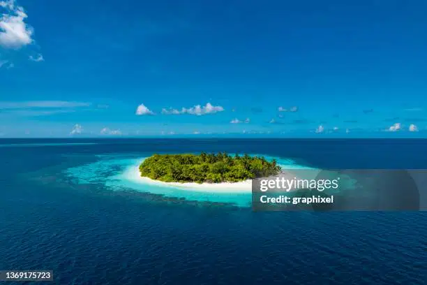
Land area, smaller than a continent, completely surrounded by water.
Lake
Island
Mountain
Hill
Plateau
Sizeable inland body of water.
River
Island
Plateau
Lake
Ocean
Land with steep sides that rises sharply (1,000 feet or more) from surrounding land, generally larger and more rugged than a hill.
Mountain
Valley
Island
River
Hill

One of the "five" major bodies of saltwater that surround the continents.
Lake
Plateau
River
Island
Ocean
Landform surrounded by water on the majority of its border while being connected to a mainland from which it extends.
River
Ocean
Peninsula
Beach
Hill
Area of flat or rolling land at a higher elevation than the surrounding land.
River
Plateau
Mountain
Hill
Island
Large natural stream of water that runs through the land.
Ocean
Lake
Delta
River
Basin

Narrow waterway between two landmasses that join two larger bodies of water.
River
Strait
Peninsula
Island
Lake

A point on a surface that is higher in elevation than all points immediately adjacent to it.
Valley
Canyon
Mountain
Hill
Summit
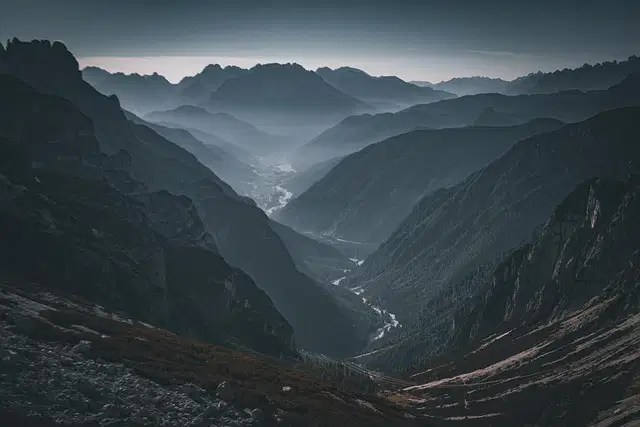
Area of low land usually between hills or mountains.
Plains
Valley
Desert
Lake
Canyon

Mountain or hill created as liquid rock and ash erupt from inside the Earth.
Desert
River
Island
Volcano
Canyon
Low lying land built up from soil carried downstream by a river and deposited at its mouth.
Hill
Valley
Delta
Desert
Lake
A deep valley with steep rocky walls.
River
Mountain
Hill
Canyon
Island

Natural void in the ground often formed by the weathering of rock.
Cave
Canyon
Valley
River
Ocean
What is an epicenter?
The point on Earth's surface, closest to the origin of the earthquake
The exact location of the earthquake

What type of fault is the San Andreas in California?
Convergent
Transform
Optimus Prime
Divergent
Which seismic wave travels the fastest, always being the first detected by seismic stations?
P waves
S waves
Surface waves
Tsunami waves
All of the following are reasons some buildings are damaged more than others during an earthquake EXCEPT....
The strength of the building materials.
How close the building was to the earthquake's epicenter.
What type of soil the building sat on.
The people living inside of the building.
The design of the building.
What does a seismograph measure?
The amount of oil and gas underground.
The amount of damage an earthquake causes.
The temperature of the earth's core.
The amount of shaking of the crust.

