
Font size
 Worksheets
Physical Fieldwork - Revise
Total questions: 89
Worksheet time: 45mins
What is the fieldwork hypothesis or enquiry question for the Dawlish Warren investigation?
‘The sea defences at Dawlish Warren are effective’
‘The sand dunes at Dawlish Warren are increasing in size’
‘The population of Dawlish Warren is declining rapidly’
‘The climate at Dawlish Warren is becoming colder each year’
What is Dawlish Warren formed by?
Dawlish Warren is a sand spit formed by long shore drift and deposition.
Dawlish Warren is a limestone plateau formed by volcanic activity.
Dawlish Warren is a granite outcrop formed by glacial erosion.
Dawlish Warren is a clay basin formed by river meandering.
Which of the following is an example of hard engineering used at Dawlish Warren?
Dune regeneration
Beach nourishment
Groynes
Planting trees
Which of the following is an example of soft engineering used at Dawlish Warren?
Sea walls
Rip rap
Dune regeneration
Concrete barriers
List the three criteria used to manage risk during the Dawlish Warren fieldwork and briefly explain each one.
S – safe to carry out, A – accessible, P – possible. Safe: risk assessment and actions to limit risk; Accessible: easy to get there; Possible: can be done in the available time.
S – secure, A – affordable, P – practical. Secure: ensure no theft; Affordable: within budget; Practical: easy to organize.
S – simple, A – accurate, P – permanent. Simple: easy to understand; Accurate: correct data; Permanent: lasting results.
S – sustainable, A – adaptable, P – predictable. Sustainable: environmentally friendly; Adaptable: can change plans; Predictable: outcomes are known.
What is the first stage in the Six Stages of Enquiry?
Think of a suitable question or hypothesis to investigate.
Collect and record data.
Analyse the results and draw conclusions.
Present your findings to others.
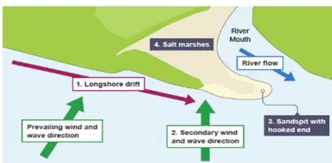
Describe what a spit is and how it forms, based on the diagram and explanation provided.
A spit is an extended stretch of sand or shingle jutting out into the sea from the land, formed by longshore drift and deposition. It forms when there is a change in the shape of the coastline, and sediment is carried by longshore drift and deposited, creating a ridge.
A spit is a type of underwater volcano that erupts and forms new islands.
A spit is a deep trench in the ocean floor created by tectonic activity.
A spit is a mountain formed by the accumulation of lava flows over time.
Why is Dawlish Warren at threat from erosion?
It is at threat from erosion because it is a sand spit and a popular destination, making it vulnerable to natural processes and human activity.
It is at threat from erosion because it is located in a mountainous region with frequent landslides.
It is at threat from erosion because it is surrounded by dense forests that trap water.
It is at threat from erosion because it is built on solid rock, making it unstable.
What combination of methods did you use for your fieldwork?
Only Qualitative methods
Only Quantitative methods
Qualitative, Quantitative, Primary and Secondary methods
Only Primary methods
What is stratified sampling used for in this fieldwork?
To choose sites on the section of coastline.
To measure the height of the waves.
To record the temperature of the water.
To identify the type of rocks present.
Which method involves reviewing satellite imagery to understand how the coastline has changed over time?
Satellite imagery
Soil sampling
Underwater diving
Tree ring analysis
Which method is described as: 'Measured the sediment height either side of the groyne to see if there is evidence of long shore drift.'?
Groyne Measurements
Beach Profiling
Wave Counting
Sediment Sieving
What is one potential issue with using sketches as a method in fieldwork?
Bad if no labels.
Always too colorful.
Require expensive equipment.
Only usable indoors.
Wave measurements and the Longshore drift test can be affected by wind speed and the tide.
True
False
What is the main purpose of a Bi-Polar Survey in this fieldwork?
To measure observable criteria to measure effectiveness of defences.
To record the temperature changes over time.
To identify the types of vegetation present.
To calculate the total rainfall in the area.
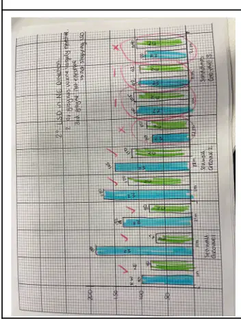
What type of graph was used to present the data on the average height of groyne visible on each side?
Bar graph
Line graph
Pie chart
Scatter plot
What was the average height difference (range) of the sediment between the south-west and north-east sides of the groynes?
108 cm
56 cm
210 cm
75 cm
According to the data analysis, what does the graph suggest about the direction of Long Shore Drift?
It was occurring in a North Easterly direction.
It was occurring in a South Westerly direction.
It was occurring in a South Easterly direction.
It was occurring in a North Westerly direction.
Groyne 3 was damaged in places and showed little/no variation in groyne height on either side.
True
False
What was the overall effectiveness of the groynes according to the results?
Groynes were effective (mostly)
Groynes caused significant erosion
Groynes had no impact
Groynes increased flooding
What is the true value in the context of measurement? Fill in the blank: The true value is the value that would be obtained in an ________ measurement.
ideal
approximate
random
erroneous
What does accuracy mean in the context of measurement? Fill in the blank: Accuracy is how close a measurement is to the ________ value.
true
average
random
measured
What is the definition of error in measurement? Fill in the blank: Error is the difference between the value that you found and the ________ value.
true
average
random
measured
What is measurement error? Fill in the blank: Measurement error refers to mistakes made when ________ the data (such as someone misreading a clinometer).
collecting
analyzing
storing
sharing
What is operator error? Fill in the blank: Operator error refers to differences in the results collected by different ________ (such as different people giving different environmental quality scores).
people
machines
locations
times
What is sampling error? Fill in the blank: Sampling error occurs where a sample is ________. Some elements of the population are less likely to be included than others.
biased
random
large
complete
What is validity in the context of research? Fill in the blank: Validity is the suitability of the method to answer the question that it was ________ to answer.
intended
forgotten
ignored
avoided

According to the data presentation/results, which sea defence had the highest average rating in the bipolar survey?
Sea Wall
Rip Rap
Sand dunes
Based on the longshore drift test, in which direction did the orange float move?
South-west
North-east
South-east
One impact of using only 3 out of 15 groynes for measurement was:
Increased accuracy of results
Reduced reliability of data
More comprehensive data collection
No effect on the results
What is the main focus of the fieldwork investigation at Dawlish Warren?
Tourism impact
Effectiveness of sea defences
Marine biodiversity
Urban expansion
What physical process is responsible for the formation of Dawlish Warren?
Erosion
Longshore drift
Deposition
Both b and c
Which of the following is a type of hard engineering used at Dawlish Warren?
Sand dune regeneration
Groynes
Beach nourishment
Managed retreat
What type of sampling method was used to select sites for data collection?
Systematic
Random
Stratified
Convenience
Which of the following is an example of soft engineering?
Rip rap
Sea walls
Beach nourishment
Rock armour
Why was Dawlish Warren chosen as the fieldwork location?
It is a remote location with minimal human influence
It is easily accessible and a public area
It is a site of urban redevelopment
It has a completely natural coastline
Which of these is a type of error that could affect fieldwork accuracy?
True value error
Hypothesis error
Sampling error
Process error
What does 'validity' refer to in the fieldwork process?
How close measurements are to the true value
The suitability of the method to answer the question
The difference between a recorded value and a true value
The presentation of data
What was one way risks were managed during the fieldwork?
Collecting data only at high tide
Conducting a risk assessment before the trip
Avoiding data collection on beaches
Using drones to replace in-person fieldwork
Which of the following is a primary data collection method?
Using maps from a government website
Measuring the height of groynes
Reading journal articles about coastal defences
Looking at old photographs of the coastline
Fieldwork Hypothesis should be written how many times?
4 times
5 times
6 times
7 times
Longshore drift is the movement of sediment along a coast by wave action. How does longshore drift contribute to the formation of a sand spit?
By transporting sand parallel to the shore, which accumulates and extends out from the coast
By eroding the coastline and removing all sand from the area
By causing waves to move directly towards the shore, preventing sand accumulation
By creating underwater currents that remove sand from the beach
Which two types of hard engineering are used at Dawlish Warren to help protect the coastline?
Groynes and sea walls
Gabions and sand dunes
Beach nourishment and managed retreat
Salt marsh creation and offshore reefs
Which of the following best explains the difference between qualitative and quantitative data, using an example from fieldwork at Dawlish Warren?
Qualitative data describes characteristics or qualities, such as observations about plant types, while quantitative data involves numbers, such as counting the number of plant species.
Qualitative data involves numbers, such as measuring the height of sand dunes, while quantitative data describes characteristics, such as the color of the sand.
Qualitative data and quantitative data both refer to numerical measurements taken during fieldwork.
Qualitative data is only collected in laboratories, while quantitative data is only collected in the field.
Stratified sampling was used instead of random sampling when selecting data collection sites because:
it ensures all subgroups are represented in the sample.
it is easier to implement than random sampling.
it requires less planning than random sampling.
it eliminates all bias from the sample.
Possible sources of error in fieldwork data collection include:
Instrument malfunction, human error, and environmental factors
Only instrument malfunction
Only human error
Only environmental factors
The title of your physical geography fieldwork enquiry is:
A) Investigating River Processes
B) Studying Urban Land Use
C) Exploring Economic Activities
D) Analysing Historical Monuments
A) Investigating River Processes
B) Studying Urban Land Use
C) Exploring Economic Activities
D) Analysing Historical Monuments
One potential risk in physical geography fieldwork is slipping on wet ground. How was this risk reduced?
By wearing appropriate footwear
By carrying extra equipment
By working alone
By avoiding all fieldwork
Anomalies in your data could affect your fieldwork enquiry by:
Making your results less reliable
Improving the accuracy of your conclusions
Ensuring all data is consistent
Having no impact on your findings
Which of the following best describes the title of your physical geography fieldwork enquiry and assesses the effectiveness of your data collection method(s)?
To investigate river velocity and evaluate the accuracy of flow meter readings.
To study urban microclimates and assess the reliability of temperature data loggers.
To examine coastal erosion and judge the effectiveness of sediment sampling methods.
To analyze soil profiles and review the precision of soil moisture probes.
Based on the background information provided, what is the fieldwork hypothesis or enquiry question for the Cranbrook study?
‘Change to the urban area of Cranbrook has had a positive impact on quality of life’
‘Cranbrook’s population has decreased due to urban change’
‘The rural area of Cranbrook has remained unchanged’
‘Cranbrook’s quality of life has declined due to industrialization’
Where is Cranbrook located?
Cranbrook is located in East Devon, England, 9 kilometres (5.6 mi) east-north-east of the centre of Exeter.
Cranbrook is located in North Yorkshire, England, near the city of York.
Cranbrook is located in South Wales, close to Cardiff.
Cranbrook is located in the Scottish Highlands, north of Inverness.
A suitable question or hypothesis to investigate for a human fieldwork enquiry is:
What is the impact of pedestrian traffic on local businesses?
How does weather affect outdoor activities?
What are the main reasons for urban migration?
How do public transport options influence commuting patterns?
Choose one or two fieldwork methods to collect data that will help you to answer your enquiry question. Which of the following is a suitable fieldwork method?
Questionnaire survey
Laboratory experiment
Online research
Literature review
Select two or three ways to process and present the data in the form of graphs, maps, images or tables.
Graphs, maps, and tables
Graphs, images, and tables
Maps, images, and tables
Graphs, maps, and images
The data you have presented from your fieldwork in Cranbrook should be:
Described, analysed and explained
Ignored
Only described
Only explained
Draw conclusions to answer the original question or hypothesis you set out to investigate about Cranbrook.
Cranbrook is a historic town with significant cultural heritage.
Cranbrook is a modern city with little historical significance.
Cranbrook is primarily known for its industrial development.
Cranbrook is a coastal city with a large port.
Evaluate your enquiry to say how well you think it went and how you could improve it.
It went well and I could improve by being more specific.
It did not go well and I need to ask clearer questions.
I am unsure about how it went and need more feedback.
I did not make an enquiry.
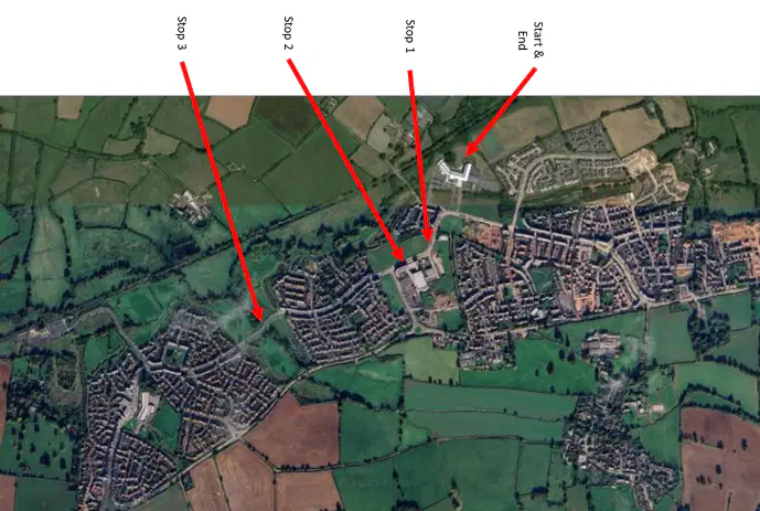
Which of the following best explains why the labelled sites (Site 1, Site 2, Site 3, Site 4, Site 5, Site 6, Site 7, Site 8) might be important for your fieldwork enquiry?
They represent different types of land use or features relevant to the enquiry.
They are randomly selected points with no significance.
They are the only accessible locations in the area.
They are historical landmarks unrelated to the enquiry.
What does the 'S' in the S-A-P approach to risk management stand for?
safe to carry out
secure to perform
suitable to proceed
satisfactory to attempt
Which sampling method was used to choose sites in Cranbrook?
Random sampling
Stratified sampling
Systematic sampling
Cluster sampling
Which method involves reviewing imagery to understand how an area has changed over time?
Research
Satellite imagery
Place Standard Survey
Sketch
The Place Standard Survey is designed to assess the quality of new and existing places to identify where improvements may be needed.
True
False
What type of data is collected by drawing a labelled sketch of the new town centre?
Primary Qualitative
Secondary Quantitative
Primary Quantitative
Secondary Qualitative
Which of the following is a disadvantage of using the Place Standard Survey?
Provides context to the area
Gives an overview of the area prior to visiting
Difficulty in ranking certain themes as there were some polar views
Supports planning
Fill in the blank: The value that would be obtained in an ideal measurement is called the _________.
True value
Measured value
Estimated value
Apparent value
Fill in the blank: ________ is how close a measurement is to the true value.
Accuracy
Precision
Error
Uncertainty
Fill in the blank: ________ is the difference between the result that you found and the true value.
Error
Unit
Average
Sum
Fill in the blank: ________ are mistakes made when collecting the data (such as someone misreading a clinometer).
Measurement error
Sampling bias
Random error
Systematic error
Fill in the blank: ________ are differences in the results collected by different people (such as different people giving different environmental quality scores).
Operator error
Instrument error
Random error
Systematic error
Fill in the blank: ________ is where a sample is biased. Some elements of the population are less likely to be included than others.
Sampling error
Random sampling
Population mean
Normal distribution
Fill in the blank: ________ is the suitability of the method to answer the question that it was intended to answer.
Validity
Reliability
Feasibility
Objectivity
Match the following sources of error with their impacts on quality:
Sample size
Less reliable. IMPROVE – ASK MORE PEOPLE TO CONDUCT PLACE STANDARD SURVEY
Frequency of sample
less reliable than if measured on multiple occasions. IMPROVE – DO MORE TIMES (REPEAT).
Type of sampling
not wholly representative of the population nor true value. – Inaccurate/unreliable data. IMPROVE – CHANGE SAMPLING METHOD
Equipment used
Difficult to agree qualitative scale for Place Standard Survey; turn peoples comments into a ranking. IMPROVE – BETTER TRAINING/ MORE TIME DECIDING RANKINGS.
Time of survey
Not many people around. IMPROVE – CHANGE TIME.
What was the main enquiry question for the fieldwork?
Has tourism increased in Cranbrook?
How has Cranbrook affected traffic in Exeter?
Has the development of Cranbrook had a positive impact on quality of life?
Is Cranbrook a suitable place for retirement?
Where is Cranbrook located?
West of Exeter, Devon
East-north-east of Exeter, Devon
In central Exeter
South of Plymouth
Which of the following is NOT part of the Cranbrook masterplan's focus?
Transport and movement
Historical preservation
Urban design and infrastructure
Health and wellbeing
Which of the following describes Cranbrook’s transport options?
It has no railway station.
It is connected by bus routes, a train station, and is near an airport.
It is only accessible by private vehicle.
It relies exclusively on bike paths.
What type of sampling was used to choose survey sites in Cranbrook?
Random sampling
Systematic sampling
Stratified sampling
Snowball sampling
What kind of survey was used as part of the fieldwork?
Travel diary survey
Environmental impact survey
Place Standard Survey
Housing quality survey
What is a “measurement error” in the context of fieldwork?
Choosing the wrong hypothesis
Biased sample group
Mistakes made when collecting data
Outdated secondary data
Why was Cranbrook considered a suitable location for fieldwork?
It was far away and difficult to reach
It was a private estate
It was accessible, safe, and possible to complete in one day
It had extreme weather conditions
Which of the following is an example of an operator error?
Misreading a map
Using out-of-date population data
Different people giving different environmental quality scores
Having too few survey responses
What does “validity” refer to in fieldwork?
How many people completed the survey
Whether the method answers the intended question
Whether the data is quantitative
The cost of conducting the fieldwork
One set of data you collected in your Human fieldwork enquiry may not have been reliable because:
There may have been human error during data collection.
The weather conditions were perfect.
All equipment used was brand new and accurate.
The data was collected by a large, experienced team.
Which of the following can be justified for use in a human geography fieldwork enquiry?
Maps
Graphs
Tables
Diagrams
Anomalies in your data could affect your fieldwork enquiry by:
Making your results less reliable
Improving the accuracy of your conclusions
Ensuring all data points are consistent
Having no impact on your analysis
The title of your human geography fieldwork enquiry is:
Urban Land Use Patterns
River Processes and Landforms
Coastal Erosion
Glacial Landscapes
The data collected for one of your enquiries allowed you to reach valid conclusions to what extent?
To a great extent
To some extent
To a small extent
Not at all
Title of fieldwork enquiry: ____________________________
Impact of pollution on local river
Survey of local plant species
Traffic patterns in city center
Effects of tourism on coastal areas

