
 Worksheets
Unit 1: Geography Review
Total questions: 75
Worksheet time: 45mins
The pattern of where people live within a country or region.
Political Map
Population Distribution
Cultural Region
Population Density
A border that uses physical features such as rivers, oceans, deserts, and mountains.
Natural Border
Artificial Border
Cultural Region
Population Density
A map that shows natural features such as mountains, rivers, and lakes.
Political Map
Physical Map
Cultural Region
Infrastructure
The systems or structures a country relies on such as roads or electricity lines.
Infrastructure
Population Density
Cultural Region
Longitude
A border that is man made and can be either political or cultural.
Natural Border
Artificial Border
Population Distribution
Latitude
A map that shows countries, states, cities, and borders.
Political Map
Physical Map
Cultural Region
Population Density
The number of people living in a specific area.
Population Distribution
Population Density
Cultural Region
Longitude
Imaginary lines that run north and south and are vertical on the map.
Latitude
Longitude
Infrastructure
Cultural Region
Imaginary lines that run east and west and are horizontal on the map.
Latitude
Longitude
Infrastructure
Cultural Region
A geographic area where people share a similar culture, including traits like language, religion, ethnicity, and customs.
Political Map
Cultural Region
Natural Border
Population Density
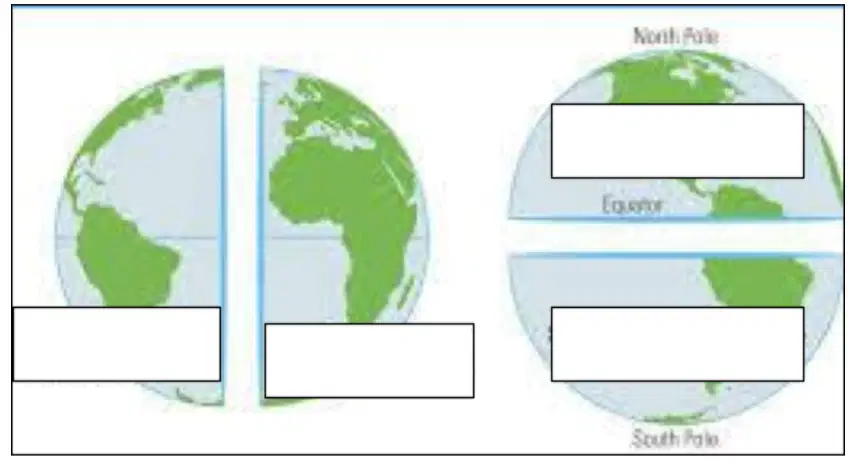
Which hemisphere is located above the Equator?
Northern Hemisphere
Southern Hemisphere
Eastern Hemisphere
Western Hemisphere
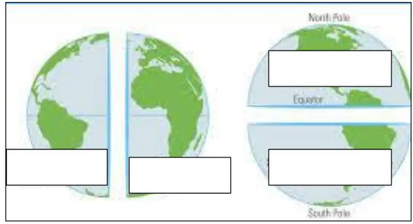
Which hemisphere is located to the right of the Prime Meridian?
Eastern Hemisphere
Western Hemisphere
Northern Hemisphere
Southern Hemisphere
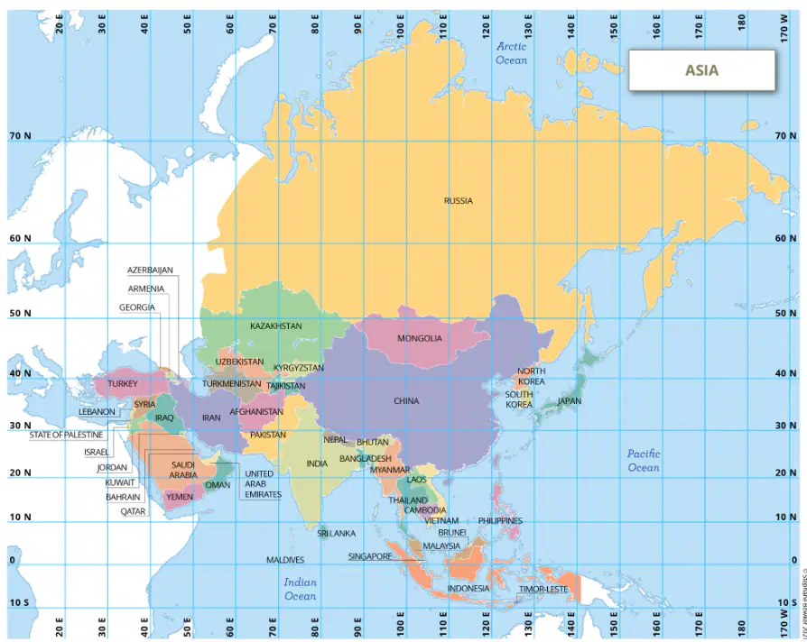
Which country is at 20°N, 80°E?
Russia
China
India
Saudi Arabia
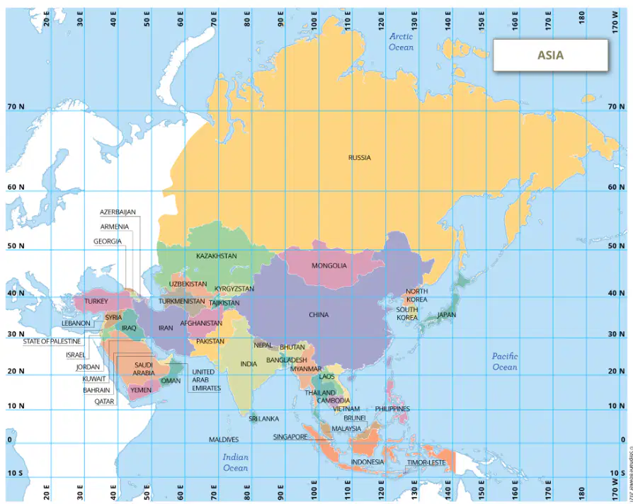
Which country is found at 50°N, 100°E?
Mongolia
Laos
Indonesia
Thailand

Which letter labels the Atlantic Ocean?
K
B
J
D

Which letter labels Africa?
E
A
C
H

Which letter labels North America?
I
A
D
G

Which letter labels the Indian Ocean?
L
B
C
F

Which letter labels South America?
I
F
G
H

Which letter labels Europe?
A
K
E
L

Which letter labels the Arctic Ocean?
F
A
D
C

Which letter labels Asia?
G
D
J
I

Which letter labels the Pacific Ocean?
C
B
K
F

Which letter labels Australia?
D
H
I
C

Which letter labels the Southern Ocean?
A
E
F
J

Which letter labels Antarctica?
L
H
C
K

The Prime Meridian goes from _____ to ______?
East. West
Left, Right
North, South
Front, Back

Equator
Prime Meridian
International Date Line
North Pole


through time
really fast in the 100 meter dash
Longitude lines run
through time
really fast in the 100 meter dash

What cardinal direction goes in the yellow box?
east
west
south
north

What cardinal direction goes in the yellow box?
north
south
east
west

What cardinal direction goes in the yellow box?
northeast
southwest
north
south

What cardinal direction goes in the yellow box?
west
east
southeast
northwest

What intermediate direction goes in the purple box?
northeast
northwest
south
west

What intermediate direction goes in the purple box?
northeast
south
west
southwest

What intermediate direction goes in the purple box?
north
southeast
west
southwest

What intermediate direction goes in the purple box?
north
northwest
northeast
south
A border that uses physical features.
Artificial Border
Falcon Border
Natural Border
Physical Border
A border that is man made and can be either political or cultural.
Natural Border
Falcon Border
Physical Border
Artificial Border
This factor helps decide if the weather will be more mild, or extreme.
Altitude
Ocean Currents
Distance from the Equator
Distance from the ocean
This factor decides that the higher you go, the colder it gets.
Altitude
Ocean Currents
Distance from the Equator
Distance from the ocean
This movement of water can make temperatures cooler or warmer.
Altitude
Ocean Currents
Distance from the Equator
Distance from the ocean
The sun’s rays hit the earth more directly in the middle of the earth, making it hotter.
Altitude
Ocean Currents
Distance from the Equator
Distance from the ocean
This zone has a high average temperature year-round of 64 degrees F or higher. Many of these areas can be jungle and are near the equator. These areas are often wet and humid. What climate zone is this?
tropical
arid
temperate
continental
polar
I don’t follow the rules of latitude! The higher you climb, the colder I get, no matter where I am on Earth.
Temperate
Tropical
Arid
Highland
Polar
I change with the seasons! I can be warm in the summer, cold in the winter, and mild in between. People grow many crops in my regions.
Temperate
Tropical
Arid
Highland
Polar
I’m cool or cold most of the time. I’m found near the poles of Earth, where snow and ice cover the land for much of the year.
Temperate
Tropical
Arid
Highland
Polar
I’m usually dry and can be very hot during the day but cold at night. You’ll find me in places with deserts and very little rainfall.
Temperate
Tropical
Arid
Highland
Polar
I’m hot and humid almost all year. I often have rainforests and lots of plants and animals that love warm weather. I am also found near the Equator.
Temperate
Tropical
Arid
Highland
Polar

What number marks South Africa?
11
13
14
15
What landform lies along the Atlantic Coast near the equator?
Sahel
Savanah
Niger River
Tropical Rain Forest
What mountain range is located in North Africa?
Mt. Kilimanjaro
Atlas Mountains
Sahel Mountains
The Alps

What country is listed as letter A?
South Africa
Democratic Republic of Congo
Nigeria
Kenya
What country is listed as letter B?
Egypt
Democratic Republic of Congo
Nigeria
Kenya

Which physical feature is located at letter N?
Niger River
Nile River
Congo River
Lake Victoria
Which physical feature is located at letter O?
Niger River
Nile River
Congo River
Lake Victoria
Which physical feature is located at letter P?
Niger River
Nile River
Congo River
Lake Victoria

Which physical feature is located at the red triangle?
Lake Victoria
Mount Kilimanjaro
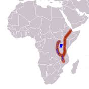
The Great Rift Valley
Nile River
Which physical feature is located at the pink 'Y" shape?
Lake Victoria
Mount Kilimanjaro
The Great Rift Valley
Nile River

Which regional feature is located at letter M?
Savanna
Atlas Mountains
Sahara Desert
Kalahari Desert
Which regional feature is located at letter K?
Savanna
Tropical Rain Forest
Sahara Desert
Sahel
Which regional feature is located at letter J?
Savanna
Tropical Rain Forest
Sahara Desert
Sahel
Which regional feature is located at letter H?
Atlas Mountains
Tropical Rain Forest
Sahara Desert
Savanna



