
NEW
Font size
 Worksheets
Intro to Geography & Geographer's Tools Test GL
Total questions: 28
Worksheet time: 14mins
When studying how humans interact with their environment, geographers are most interested in:
How people decorate their living spaces
Farming techniques
The ways people rely on, change, and adapt to their natural surroundings
Tourist travel routes
The main goal of studying geography is:
To make extremely detailed maps of every place
To only predict weather conditions
To understand how human societies connect with their physical world
To draw clear national borders
If a researcher is studying how people move around the world, they are most likely working in:
Map-making
Human geography
Geological studies
Physical geography
Geographic Information Systems (GIS) are mainly used to:
Track personal movements
Create video game landscapes
Make fun maps
Study and understand spatial information and connections by displaying data using maps
Mountains, climate, and rivers are examples of
Physical characteristics
Movement patterns
Human characteristics
Relative location
When farmers build irrigation systems to water their crops, this is an example of:
Humans modifying the environment
Humans depending on the environment
Physical characteristics of place
Humans adapting to the environment
Which theme of geography involves the study of how people, goods, and ideas travel from one place to another?
Region
Movement
Place
Location
A region defined by shared language, culture, and religion would be classified as:
Human-environmental interaction
A region with common characteristics
A physical region
An absolute location
Latitude lines measure:
Distance between cities
Time zones
distance East and West of the Prime Meridian
distance North and South of the Equator
Which is NOT one of the five themes of geography?
Region
Climate
Movement
Location
"The coffee shop is across from the post office" is an example of:
Movement
Relative location
Physical characteristics
Absolute location
What is cartography?
The study of ocean currents
The study of map making
The study of rock formations
The study of weather patterns
Why is it impossible to create a 100% accurate map of Earth?
Technology isn't advanced enough
Earth is more oval-shaped due to gravity
Maps are too small
Earth is perfectly round
What are the three main characteristics to consider when viewing a map?
Color, texture, and scale
Size, shape, and distance
North, south, and equator
Land, water, and mountains
Which map projection is best used for navigation and marine travel?
Hammer
Robinson
Mercator
Goode Interrupted
What is the main problem with the Mercator projection?
It shows too much detail
It doesn't show water
It's too colorful
Areas near the poles appear much larger than they actually are
Which type of map would you use to find the borders between countries?
Special purpose map
Physical map
Political map
General purpose map
Which type of map shows features like mountains and rivers?
General purpose map
Political map
Physical map
Special purpose map
The is an imaginary line at 0° latitude that divides Earth into Northern and Southern Hemispheres.
International Date Line
Tropic of Cancer
Prime Meridian
Equator
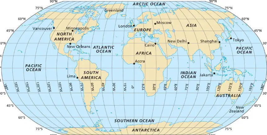
What city is located at 30°N, 90°W?
New Delhi
New Orleans
Moscow
Cairo
Geographers use the theme of _______ to describe what an area is like
Location
Place
Physical
Movement
A ___ is half the earth.
degree
line of longitude
line of latitude
hemisphere

What is the Absolute Location of Shanghai?
30°N, 75°E
30°N, 120°E
30°N, 30°E
30°N, 120°W
What is a mapmaker?
biologist
conquistador
cartographer
engineer
What is the purpose of a legend on a map?
To provide a scale for measuring distances
To explain the symbols and colors used on the map
To show the direction of north
To indicate the map's title
What is the main difference between a physical map and a political map?
Physical maps show natural features, while political maps show human-made boundaries
Physical maps show weather patterns, while political maps show population density
Physical maps show economic activities, while political maps show climate zones
Physical maps show historical events, while political maps show current events
A system that determines accurately the precise position of something on Earth through satellites, tracking stations, and receivers
GIS
GPS
What is the primary purpose of a globe?
To show the entire surface of the Earth in a spherical form
To provide detailed street maps
To display weather patterns
To show population density

