
 Worksheets
Family Academic Night Family and Student Review
Total questions: 32
Worksheet time: 19mins

Which location on the map includes physical characteristics such as deserts, cacti, droughts, the Rio Grande, and the Grand Canyon?
A
B
C
D
E
What ocean is located on the eastern coast of the U.S.?
Atlantic Ocean
Gulf of Mexico
Pacific Ocean
Rio Grande River

A small town in Texas is always dealing with flooding from a river that is nearby. Solution: ?
Build wind turbines
Clear land of timber
Reuse rainwater
Build a dam
Which mountain chain made it hard for colonists to move west?
Rocky Mountains
Appalachian Mountains
Sierra Mountains
Canadian Mountains

Part A
This excerpt describes a region in the U.S.
What claim is supported by the excerpt?
The West is also known as hurricane alley.
The Northeast has the same features as the other regions.
The Southwest is typically cold and rainy.
The Southeast is located near major bodies of water.

Part B
This excerpt describes a region in the U.S.
Which evidence supports the answer to Part A?
A. “A region is an area of land that has common features.”
B. “...consists of 14 states and spans from the Atlantic coast to the Gulf of Mexico.”
C. “...the area has extreme weather conditions...”
D. “This area is a mix of cultures and has activities for everyone.”
Determine whether the description is an adaptation. Select those that qualify as adaptation.
Collecting rainwater to water crops
Recycling to reduce waste
Clearing land of timber for farming
Building wind turbines for energy
Driving eco-friendly cars to limit pollution
Determine whether the description is an modification. Select those that qualify as modification.
Collecting rainwater to water crops
Recycling to reduce waste
Clearing land of timber for farming
Building wind turbines for energy
Driving eco-friendly cars to limit pollution

The image shows a -
suburban area
populated area
rural area
urban area

Fishing industries in states like Massachusetts and Rhode Island developed because of their -
closeness to the Atlantic Ocean
large scale fish farms
booming tourism industry
ports in the Gulf of Mexico
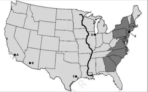
The locations on the map identify the five -
major U.S. cities
major lakes in the U.S.
oldest U.S. military bases
oil centers in the U.S.

Why are cattle ranching and dairy farming major industries in the Midwest?
The mountains and basins provide fertile land for cattle to graze on.
Access to natural harbors allows cattle to be moved across the U.S.
The Great Plains has plenty of prairie grasses for cattle to eat
Cattle stay cool in the summer because of beaches and swamps in the area.
One reason people adapt to their environment is to survive in different climates, and one reason people modify the environment is to meet their needs for resources. Which statement best describes this?
People adapt to survive and modify to meet resource needs.
People adapt to change the environment and modify to avoid resources.
People adapt to avoid the environment and modify to survive.
People adapt to meet resource needs and modify to survive.
Which of the following describes an urban area?
Public transportation, open spaces, community-planned housing
Open spaces, fast-paced and loud, outside of city
Lots of people, apartment buildings, community-planned housing
Apartment buildings, public transportation, lots of people

The bulleted list above identifies industries that are primarily located in the -
West
Northeast
Midwest
Southeast
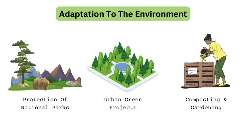
Describe one reason why people adapt to their environment AND one reason why people modify the environment
to meet their needs.


The Sun Belt is mainly found in which region of the US? (2 correct answers)
West
Midwest
Southwest
Southeast


How many regions are in the US?
3
5
1
6
What region do we live in?
east
northeast
midwest
southwest

What region is highlighted?
northeast
west
southeast
north
Which two regions do the Appalachian Mountains go through?
east and west
west and southwest
just midwest
northeast and southeast
What tool do we use on a map to tell our directions?
legend
scale
compass rose
title
What is a major industry in the southeast region?
cotton
beef
wheat
apple
How many states are in the United States?
55
49
50
51
How many great lakes are there?
3
9
2
5
What river starts in Minnesota and end in the Gulf of Mexico?
Colorado River
Missouri River
Mississippi River
New York River
What is the names of the two oceans that have coasts along the US?
Atlantic and Pacific
Gulf of Mexico and Mississippi
Atlantic and Indian
Artic and Pacific

