
 Worksheets
Unit 2: Physical Geo Review
Total questions: 52
Worksheet time: 44mins
What are the cardinal directions?
Forward, Backward, Sideways, Diagonal
Up, Down, Left, Right
North, South, East, West
Above, Below, Beside, Across
What does the map title tell you?
The author of the map
The subject of the information shown
The scale of the map
The date the map was created
Which line divides the Earth into the northern and southern hemispheres?
Tropic of Capricorn
Equator
Prime Meridian
Tropic of Cancer
What is the purpose of a compass rose on a map?
To provide the map's title
To indicate cardinal and intermediate directions
To show the map's scale
To list the map's symbols
Which of the following is a physical feature?
A road
A city
A mountain
A country's border
What is the Prime Meridian?
A line of 0° latitude
A line of 0° longitude
A line at 23.5°N
A line at 23.5°S
Which of the following is an intermediate direction?
West
North
Southeast
South
What does a map's scale help you determine?
The map's author
The distance between two locations
The map's date
The map's title

What is a continent?
A large body of water
A main continuous expanse of land
A small island
A type of climate zone
What is the Tropic of Cancer?
A line of latitude at 23.5°S
A line of latitude at 0°
A line of latitude at 23.5°N
A line of longitude at 0°

Which type of map shows physical features like mountains and rivers?
Climate map
Physical map
Thematic map
Political map
What is the function of a map's legend?
To show the map's scale
To indicate cardinal directions
To list and explain symbols and colors
To provide the map's title

Which climate zone is characterized by warm/hot temperatures all year?
Polar zone
Arctic zone
Tropical zone
Temperate zone
What is the Tropic of Capricorn?
A line of latitude at 0°
A line of longitude at 0°
A line of latitude at 23.5°S
A line of latitude at 23.5°N
Which of the following is a thematic map likely to show?
Population density
Borders of countries
Names of rivers
Major cities

What is the purpose of the Equator?
To divide the Earth into eastern and western hemispheres
To measure distance north and south
To measure distance east and west
To divide the Earth into northern and southern hemispheres
Which of the following is NOT a continent?
Africa
Antarctica
Australia
Greenland
What is the main characteristic of a polar climate zone?
High rainfall
Cold temperatures all year
Warm temperatures all year
Moderate temperatures

Which line is used as the starting point for measuring longitude?
Prime Meridian
Equator
Tropic of Capricorn
Tropic of Cancer
What does the 'O' in TODALS stand for?
Observation
Operation
Organization
Orientation
Which of the following is a body of water?
Mountain
Ocean
Desert
Plateau

What is the main purpose of a political map?
To show borders and major cities
To show climate zones
To show physical features
To show population density
Which of the following is a landform?
Delta
Basin
Peninsula
Harbor
What is the significance of the Prime Meridian?
It divides the Earth into northern and southern hemispheres
It is the starting point for measuring latitude
It marks the boundary between two climate zones
It divides the Earth into eastern and western hemispheres
Which of the following is NOT an ocean?
Atlantic
Mediterranean
Arctic
Indian
What does the 'S' in TODALS stand for?
Symbol
System
Source
Scale
Which of the following is a transportation corridor?
Mountain range
River
Desert
Canyon
What is the main purpose of a scale on a map?
To show the map's title
To list symbols
To calculate distances
To indicate cardinal directions
Which of the following is a characteristic of a temperate climate zone?
Cold temperatures all year
Warm temperatures all year
Moderate temperatures
High humidity
What is the purpose of the Tropic of Cancer and Tropic of Capricorn?
To divide the Earth into climate zones
To measure distance east and west
To indicate the starting point for measuring longitude
To mark the boundaries of the polar zones

Which continent can be found at the intersection of 35 degrees South and 60 degrees west?
Asia
Africa
South America
Australia

Which continent can be found at the intersection of 25 degrees north and 30 degrees East?
North America
Africa
Australia
Asia
What does each letter in the acronym HAGGERS represent?
Health, Agriculture, Geography, Government, Education, Religion, Society
History, Arts, Geography, Government, Economics, Religion, Society
History, Architecture, Geography, Government, Economics, Resources, Sports
History, Aesthetics, Geography, Government, Economics, Religion, Social

Look at this map, if Whatville and Whereville are drawn 3 inches apart in the picture, how far apart are they actually in real life?
20 miles
1 inch
3 inches
60 miles

Number 4 - Western or Eastern Hemisphere?
Northern
Eastern
Western
Southern

Number 5 - Western or Eastern Hemisphere?
Eastern
Western
Northern
Southern

A narrow strip of land extending into a body of water, surrounded by water on three sides.
River
Canyon
Plateau
Peninsula
Which body of water is known for being the largest and deepest ocean on Earth?
Indian
Pacific
Atlantic
Mediterranean

Number 4 - Northern or Southern Hemisphere?
Northern
Western
Southern
Eastern

Number 7 - Northern or Southern Hemisphere?
Western
Eastern
Southern
Northern
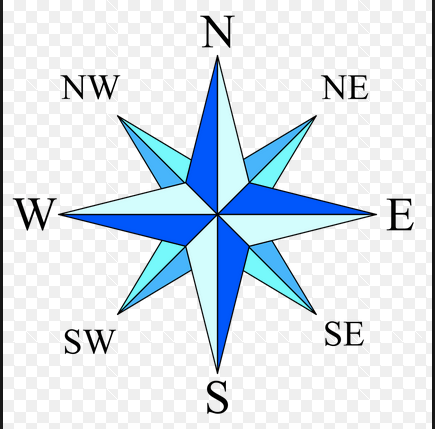

What is this map element called?
title
compass rose
legend
scale

What is this map element called?
Legend
Star Guide
Cardinal Direction
Intermediate Direction


A deep, narrow valley with steep sides, often carved by a river.
Canyon
Plateau
Cliff
Isthmus

Which feature is a flat area of land that is raised higher than the land around it and resembles a tabletop.
Peninsula
Ocean
Canyon
Plateau
second-largest ocean in the world
Pacific Ocean
Indian Ocean
Atlantic Ocean
Nile River


What is the line L called
Equator
Prime Meridian
Tropic of Cancer
Tropic of Capricorn


Which continent can be found at the intersection of 40 degrees north and 100 degrees west?
South America
North America
Antartica
Asia

Which continent can be found at the intersection of 20 degrees south and 120 degrees east?
Australia
Antartica
Africa
Europe

