
 Worksheets
2G4 SS PHYSICAL CHARACTERISTICS OF MY COUNTRY
Total questions: 76
Worksheet time: 38mins

What is the approximate area of the country shown in the diagram?
300,000 sq.km
500,000 sq.km
100,000 sq.km
700,000 sq.km

What is the shape of the country shown in the diagram?
Circular
Rectangular
Semi-triangular
Square
What is the approximate area of the region described in the image?
500,000 sq.km
300,000 sq.km
100,000 sq.km
700,000 sq.km
In which part of Asia is the region located?
Southwest Asia
Southeast Asia
Central Asia
Northeast Asia
Where is the region located in relation to the Equator?
South of the Equator
On the Equator
North of the Equator
West of the Equator
How many regions are there in the Philippines?
15
18
20
22
What are the three major islands of the Philippines?
Luzon, Visayas, and Mindanao
Cebu, Palawan, and Boracay
Manila, Davao, and Cebu
Bohol, Leyte, and Samar
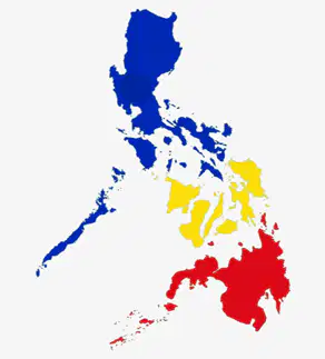
What is the name of the island highlighted blue in the image?
Mindanao
Luzon
Visayas
Palawan
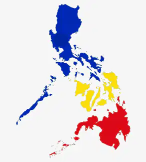
Which country is shown in the image with a flag?
Vietnam
Thailand
Philippines
Malaysia
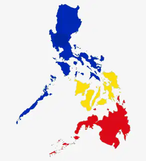
What is the name of the region highlighted yellow in the map?
Luzon
Mindanao
Visayas
Palawan
Which sea is located to the west of the Philippines as shown in the map?
Sulu Sea
South China Sea
Celebes Sea
Philippine Sea
Which region is known as Western Visayas?
Region 6
Region 7
Region 8
NIR
What is the name of Region 7?
Eastern Visayas
Central Visayas
Western Visayas
Negros Island Region
Which region is referred to as NIR?
Region 6
Region 7
Region 8
Negros Island Region
Region 8 is also known as what?
Western Visayas
Central Visayas
Eastern Visayas
Negros Island Region
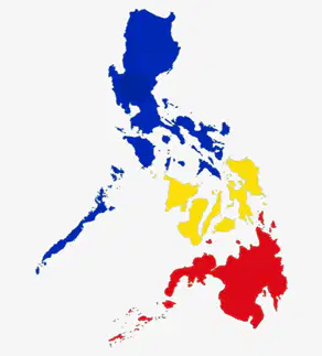
What is the name of the island highlighted red in the image?
Luzon
Mindanao
Visayas
Palawan

Which region is labeled as "Rehiyon IX" in the map of Mindanao?
Hilagang Mindanao
Tangway ng Zamboanga
Davao
Caraga
What is the name of the region labeled as "Rehiyon XIII" in the map?
Caraga
SOCCSKSARGEN
Bangsamoro Autonomous Region
Hilagang Mindanao

Which region is represented by the color red on the map?
SOCCSKSARGEN
Tangway ng Zamboanga
Davao
Caraga
Which region is known as the Zamboanga Peninsula?
Region 10
Region 9
Region 11
Region 12
What is the name of Region 11?
Northern Mindanao
Davao Region
Caraga
SOCCSKSARGEN
Which region is referred to as SOCCSKSARGEN?
Region 12
Region 13
Region 9
Region 10
What does BARMM stand for?
Bangsamoro Autonomous Region in Muslim Mindanao
Bangsamoro Autonomous Region in Mindanao
Bangsamoro Autonomous Region in Southern Mindanao
Bangsamoro Autonomous Region in Northern Mindanao
Which region is part of Luzon?
Region 6 (Western Visayas)
Region 9 (Zamboanga Peninsula)
Region I (Ilocos Region)
Region 11 (Davao)
What is the name of Region 7 in the Visayas?
Central Visayas
Eastern Visayas
Western Visayas
Northern Mindanao
Which region is known as the National Capital Region?
Region IV-A (CALABARZON)
Region V (Bicol Region)
Region 13 (Caraga)
National Capital Region (NCR)
Which region is part of Mindanao?
Region II (Cagayan Valley)
Region 12 (SOCCSKSARGEN)
Region III (Central Luzon)
Region 8 (Eastern Visayas)
What is an archipelago?
A large landmass surrounded by water
A scattered group of islands within the same body of water
A single island in the ocean
A mountain range under the sea
What is a region?
A type of plant
A kind of animal
An administrative division of territories
A type of weather
What is a calamity?
A joyful event
An event that brings terrible loss
A small inconvenience
A minor issue
What is the highest landform called?
Hill
Valley
Mountain
Plateau
What is a group of mountains called?
Mountain ranges
Hills
Valleys
Plains

Where is Mount Apo located?
Luzon
Cebu
Davao
Palawan
Where is the Sierra Madre Mountain range located?
Western Luzon
Eastern and Central Luzon
Southern Luzon
Northern Luzon
What is significant about the Sierra Madre Mountain range?
It is the shortest mountain range in the country.
It is the longest mountain range in the country.
It is the widest mountain range in the country.
It is the smallest mountain range in the country.
What is a volcano?
A type of tree
A landform that emits lava, gas, and lahar
A kind of animal
A body of water
Where is the Mayon Volcano located?
Manila
Cebu
Albay
Davao
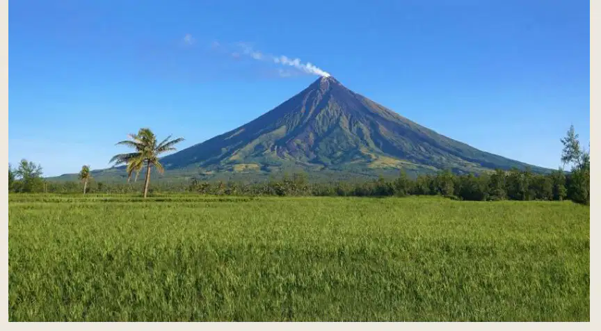
What is special about the Mayon Volcano?
It is the tallest volcano in the world
It has an almost perfect cone
It is underwater
It is the oldest volcano
What significant event happened to Mount Pinatubo on June 15, 1991?
It became a tourist attraction.
It erupted.
It was declared a national park.
It was discovered.
Which volcano is known as one of the smallest in the world?
Mount Pinatubo
Mount Everest
Taal Volcano
Mount Fuji
What is a hill?
A flat landform
An elevated landform lower than a mountain
A body of water
A type of tree
Where are the Chocolate Hills located?
Japan
Australia
Philippines
Brazil
What happens to the Chocolate Hills during the dry season?
They turn green
They turn chocolate brown
They become snowy
They disappear
What is a valley?
A high mountain peak
A low and flat landform found between mountains or hills
A large body of water
A dense forest
What makes the soil in a valley fertile?
The presence of rocks
The soil from the mountain sides
The amount of sunlight
The presence of animals
Which valley is known as "The Salad Bowl of the Philippines"?
Cagayan Valley
La Trinidad Valley
Amazon Valley
Nile Valley
What is the widest valley in the country mentioned in the text?
La Trinidad Valley
Cagayan Valley
Amazon Valley
Nile Valley
What is a plateau?
A flat landform in a high or elevated area
A low-lying area with water
A mountain with a peak
A valley with a river
What is Baguio City known as?
City of Lights
City of Pines
City of Rivers
City of Mountains
What is another name for Baguio City?
Winter Capital City of the Philippines
Summer Capital City of the Philippines
Autumn Capital City of the Philippines
Spring Capital City of the Philippines
What is a plain?
A landform with large areas of flat land
A mountain with steep slopes
A valley with a river
A desert with sand dunes
Which provinces are part of the Central Luzon Plain?
Bulacan, Nueva Ecija, Pampanga, Pangasinan, and Tarlac
Cebu, Bohol, Leyte, Samar, and Negros
Davao, Zamboanga, Cotabato, Lanao, and Sulu
Ilocos, Cagayan, Isabela, Quirino, and Aurora
What is the Central Luzon Plain often referred to as?
The Rice Granary of the Philippines
The Sugar Bowl of the Philippines
The Fruit Basket of the Philippines
The Coffee Hub of the Philippines
What is the Philippines classified as due to its characteristic of being surrounded by bodies of water?
Continental country
Maritime or insular country
Landlocked country
Desert country
What type of geographical formation is the Philippines?
Peninsula
Archipelago
Isthmus
Plateau
What is a river?
A large body of saltwater
A long and narrow water form that flows from the mountains to the ocean
A small pond
A type of mountain
How many river systems are there approximately in the Philippines?
50
100
130
More than 130
Which is the longest river in the Philippines?
Pasig River
Cagayan River
Marikina River
Agusan River
In which provinces does the Cagayan River flow?
Cagayan, Isabela, Nueva Ecija
Manila, Cebu, Davao
Bohol, Palawan, Leyte
Pampanga, Tarlac, Zambales
What was the Pasig River known for historically?
A central route of trade activities
A famous fishing spot
A popular tourist destination
A place for recreational activities
How did the culture of the country get influenced according to the text?
By the exchange of goods and ideas with Asian merchants
By the introduction of new languages
By the arrival of European explorers
By the development of new technologies
What is a lake?
A water form surrounded by land
A mountain range
A type of forest
A desert area
How many lakes are there in the country?
45
59
72
100
Which is the largest lake in the country?
Lanao Lake
Taal Lake
Laguna de Bay
Lake Victoria
Where is Lanao Lake located?
Laguna
Batangas
Lanao del Sur
Cebu
What is a waterfall?
A water form that falls from a high place or slope
A type of tree
A kind of animal
A mountain
Where is Pagsanjan Falls located?
Manila
Laguna
Cebu
Davao
What is one of the uses of Maria Cristina Falls?
Source of food
Source of electricity
Tourist attraction only
Source of drinking water
What is the biggest form of water?
River
Lake
Ocean
Sea
Where is the Pacific Ocean located in relation to the Philippines?
North
South
East
West
Which sea is found in the western part of the Philippine archipelago?
South China Sea
West Philippine Sea
Sulu Sea
Celebes Sea
What is the study of the physical features of a place or country called?
Geography
Topography
Cartography
Geology
What is a bay?
A large body of water surrounded by land
An inlet of the sea or other body of water usually smaller than a gulf
A flowing body of water
A mountain range
What is a spring?
A type of tree
A source of water that comes from the ground
A large ocean wave
A type of bird
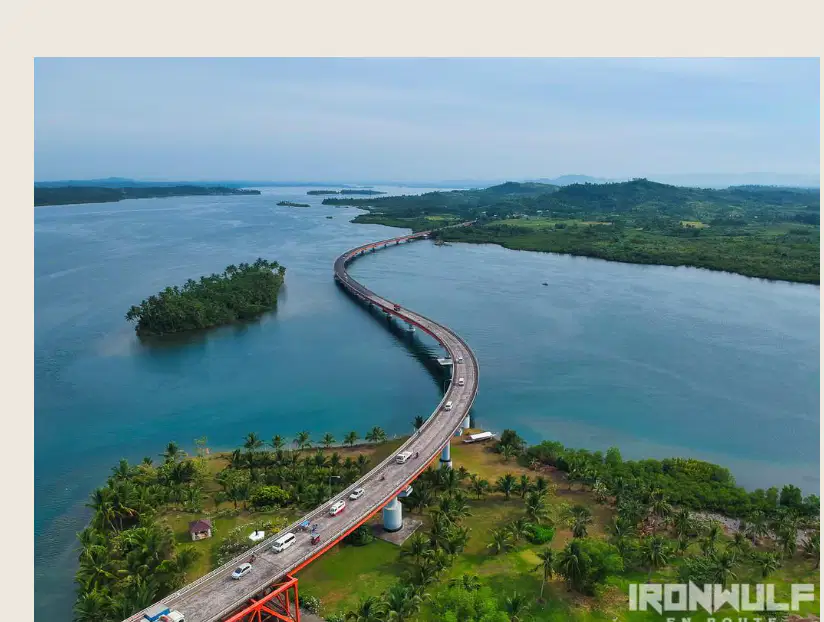
What is a strait?
A narrow canal that separates two different islands.
A part of the ocean extending into the land.
A large body of water surrounded by land.
A small river flowing into a sea.
What is a gulf?
A narrow canal that separates two different islands.
A part of the ocean extending into the land, usually bigger than a bay.
A small stream flowing into a river.
A large lake surrounded by mountains.

