
 Worksheets
Island Life
Total questions: 62
Worksheet time: 31mins
What is the Equator?
An imaginary line around the middle of the earth at an equal distance from the North Pole and the South Pole.
The highest mountain on earth.
A type of animal found in the jungle.
A kind of weather.
Which of the following best describes "Climate"?
The general weather conditions usually found in a particular place.
The height of the land above sea level.
The way people dress in different countries.
The study of animals.
What does "Latitude" measure?
The position north or south of the equator measured from 0° to 90°.
The position east or west of the equator.
The number of people in a city.
The amount of rainfall in a year.
Which of these is a human feature?
A house
A river
A mountain
A forest
What is the Prime/Greenwich Meridian?
The imaginary line from the North Pole to the South Pole that passes through Greenwich in England and marks 0° longitude.
The highest mountain in England.
The line that separates the northern and southern hemispheres.
The border between two countries.
What is culture?
The way of life, especially the general customs and beliefs, of a particular group of people at a particular time.
The type of food people eat.
The clothes people wear.
The weather in a place.
Which of the following is a topographical feature?
Related to the study of the physical appearance of the natural features of the land.
The study of animals.
The way people talk.
The type of food grown in a place.
What does colour help artists do?
Set moods and highlight the importance of an object.
Make music.
Build houses.
Grow plants.
What is texture in art?
The feeling of a surface that is real or represented as rough or smooth.
The type of paint used.
The size of the artwork.
The number of colours used.
Which of the following is an example of a physical feature?
A mountain
A car
A school
A painting
Which hemisphere is the northern half of the earth below the equator?
Southern Hemisphere
Northern Hemisphere
Eastern Hemisphere
Western Hemisphere
What is form in art?
The organisation, shape and structure of the art work.
The colour of the art work.
The size of the art work.
The type of paint used.
What does space refer to in art?
Both the depth and surface area of the art work.
The colour of the art work.
The type of material used.
The artist’s name.

Which is the largest continent in the world?
Africa
Asia
Europe
Australia
Which continent has the smallest population?
Europe
Australia
Antarctica
Africa
Which continent is mainly located in the western hemisphere and contains countries like Canada and Mexico?
North America
South America
Africa
Europe
Which continent is the location of the South Pole and has no countries?
Australia
Antarctica
Africa
Asia
Which continent contains countries like Brazil, Argentina, and Chile?
Africa
Europe
South America
Asia
What is the second largest continent in the world?
Africa
Europe
Asia
North America
Which continent is the smallest in the world?
Europe
Australia
Antarctica
South America
Which continent contains countries like the United Kingdom, France, Germany, and Italy?
Asia
Africa
Europe
North America
If you wanted to visit the continent with the most people, where would you go?
Africa
Asia
North America
Europe
Which continent is mainly located in the Eastern and Northern Hemispheres and contains countries like China and India?
Africa
Europe
Asia
Australia
Which continent is the world’s southernmost and is the location of the South Pole?
Australia
Antarctica
Africa
Europe
What direction do lines of latitude run around the Earth?
North-South
East-West
Up-Down
Diagonal
Which line runs around the middle of the Earth and separates the Northern and Southern Hemisphere?
Tropic of Cancer
Arctic Circle
Equator
Antarctic Circle
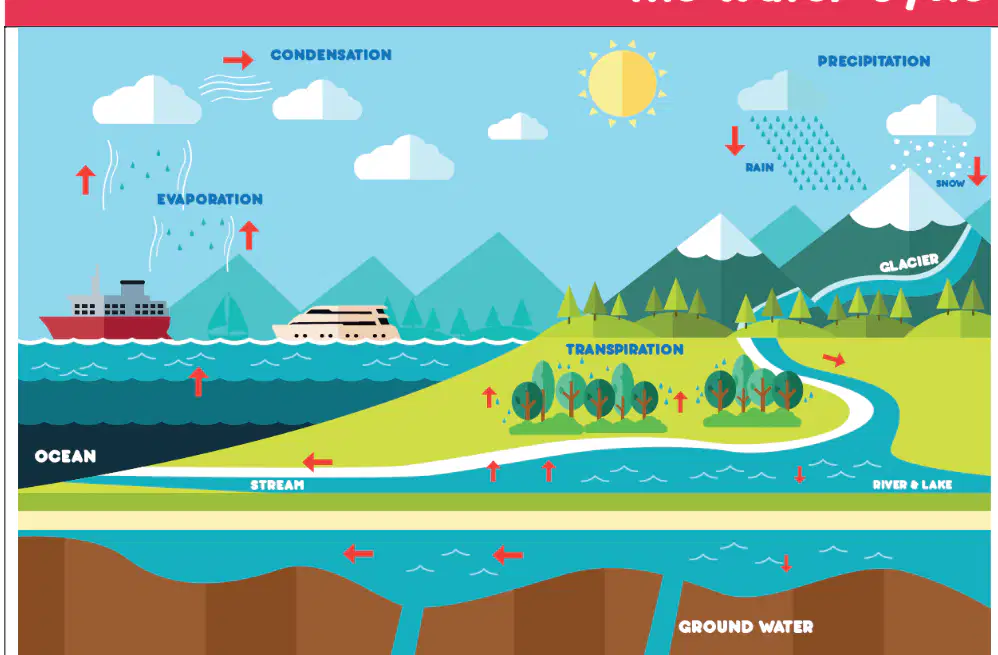
What happens when water vapor in the air cools down?
It turns into ice
It condenses into clouds
It disappears
It turns into wind
Which of the following is true about the water cycle?
Water is used only once
Water is constantly moving and recycled
Water never returns to the sea
Water only evaporates from lakes
What is the Tropic of Capricorn?
The latitude line that is 23 degrees above the equator
The latitude line that is 23 degrees below the equator
The line that runs around the middle of the Earth
The northernmost part of our planet
Why do places inside the Arctic Circle have 24 hours of darkness on the December solstice?
Because of the Earth's tilt
Because of the water cycle
Because of the equator
Because of the longitude lines
What happens after rain falls to the ground in the water cycle?
It stays on the ground forever
It returns to the sea
It turns into clouds right away
It disappears
Which direction do lines of longitude run?
East-West
North-South
Diagonal
Circular
If you wanted to find the Southernmost part of our planet, which line would you look for?
Equator
Tropic of Cancer
Antarctic Circle
Arctic Circle
What tool is used for showing direction on a map?
Compass
Ruler
Pencil
Eraser
Which direction does 'E' stand for on a compass?
East
West
North
South
What are the numbers called that run from west to east on a map grid?
Eastings
Northings
Symbols
Keys
What do the numbers called 'northings' show on a map?
They run from south to north
They run from west to east
They show symbols
They show colors
What is a key on a map used for?
To tell you what a symbol means
To open a door
To draw lines
To find directions
Which symbol on a map shows a river?
A wavy blue line
A green tree
A pink circle
A blue square with a 'P'
If you see a green tree symbol on a map, what does it mean?
Woodland
Car parking
Main road
Bus station
How do you create a four-figure grid reference on a map?
By putting together the easting and northing numbers
By drawing a circle
By using only one number
By coloring the map
Why do maps use symbols instead of words?
To label real-life features quickly
To make the map colorful
To make the map bigger
To confuse people
Which symbol would you look for if you wanted to find a car parking area on a map?
A blue square with a 'P'
A green tree
A pink circle
A triangle
Where are the Tropics of Cancer and Capricorn located on a world map?
Near the North and South Poles
Near the Equator
In the middle of the Atlantic Ocean
Only in the Northern Hemisphere
What is the main purpose of using an Ordnance Survey (OS) map?
To find the weather
To locate places using grid references
To draw pictures
To learn about animals
Which of the following is a stage of the water cycle?
Melting
Evaporation
Freezing
Burning
Why might the climate of the Caribbean be different from the UK?
The Caribbean is closer to the Equator
The UK is an island
The Caribbean has more mountains
The UK has more animals
What does the blue "P" symbol usually mean on a map?
Playground
Parking
Post office
Park
What is one way that people in different countries can be different?
They all eat the same food
They have different traditions and values
They all speak the same language
They all wear the same clothes
What is the equator, and how does it divide the Earth?
The equator is a line that divides the Earth into the Northern and Southern Hemispheres.
The equator is a mountain range that runs across the Earth.
The equator is a river that flows around the world.
The equator is a city in the middle of the Earth.
Can you explain what longitude and latitude are? How did you use these to locate islands?
Longitude and latitude are lines on maps that help us find places.
Longitude and latitude are types of weather.
Longitude and latitude are names of oceans.
Longitude and latitude are kinds of animals.
What is the difference between human and physical features?
Human features are made by people, and physical features are natural parts of the Earth.
Human features are types of weather, and physical features are types of food.
Human features are animals, and physical features are plants.
Human features are colors, and physical features are shapes.
Can you name the five ways islands are formed?
Volcanic, continental, artificial, coral, barrier
Mountain, river, desert, forest, lake
Rain, snow, wind, sun, cloud
City, town, village, farm, school
How does the climate of your island affect the way people live there?
The climate affects what people wear, what they eat, and how they build their homes.
The climate decides what games people play.
The climate changes the color of the sky.
The climate makes people taller.
What is a tributary?
Tributary is a smaller river that joins a bigger one, source is where a river begins, and flood plain is flat land near a river.
Tributary is a mountain, source is a city, and flood plain is a desert.
Tributary is a type of animal, source is a kind of food, and flood plain is a building.
Tributary is a color, source is a shape, and flood plain is a song.
Who was Charles Darwin, and why is he important?
He was a famous artist who painted islands.
He was a scientist who studied islands and helped people understand plants and animals.
He was a king who ruled over many islands.
He was a sailor who discovered new lands.
What did Darwin discover during his exploration of islands like the Galapagos?
He found new types of food.
He discovered how animals and plants can be different on each island.
He built new houses for people.
He learned how to make maps.
How did Darwin’s findings change the way people understood plants and animals?
People started to believe that all animals are the same everywhere.
People learned that animals and plants can change and adapt to their environment.
People stopped studying animals and plants.
People thought animals and plants never change.
What is one difference between copying art and being inspired by an artist's work?
Copying art means making the exact same thing, while being inspired means creating something new using ideas from the artist.
Copying art is always better.
Being inspired means you do not use any ideas from the artist.
There is no difference.
Why is it important to know about people in different countries and their traditions?
It helps us understand and respect other cultures.
It makes us forget our own traditions.
It is not important at all.
It only helps when we travel.
What can happen when people from different places share their cultures?
They can learn from each other and find things they have in common.
They will always disagree.
They will forget their own culture.
Nothing will happen.
Why is valuing diversity important for equal opportunities?
It helps everyone have a fair chance
It makes people the same
It means only some people are important
It stops people from working together

