
 Worksheets
OCE 2001 Chapter 7 Practice
Total questions: 170
Worksheet time: 3hrs 55mins
Surface currents in the ocean are best described as (a) .
Match each factor with the type of ocean current it primarily drives.
Wind
Surface ocean currents
Differences in density caused by temperature and salinity
Deep ocean currents
Tidal forces
Tidal currents
Earth's rotation
Global circulation patterns (gyres)
Match the following types of ocean currents with their characteristic motions.
Surface currents
Currents primarily driven by wind and occurring at the ocean's surface
Deep currents
Currents involving both vertical and horizontal motions in the deep ocean
Tidal currents
Currents caused by the gravitational pull of the moon and sun
Coastal currents
Currents found along the edges of continents
Explain how the driving forces behind surface currents and deep currents differ, and discuss the implications for ocean circulation.
Surface currents are wind-driven and primarily horizontal, while deep currents are driven by density differences and involve both vertical and horizontal motions, affecting global heat and nutrient distribution.
Both surface and deep currents are wind-driven and only move horizontally, so they have similar effects on ocean circulation.
Surface currents are caused by tides, while deep currents are caused by underwater earthquakes, with little impact on ocean circulation.
Surface currents are driven by temperature, while deep currents are driven by wind, both moving only vertically.
Which of the following is a direct method for measuring surface currents?
Pressure gradients
Radar altimeters
Floating device tracked through time
Doppler flow meter
Which method is considered an indirect way to measure surface currents?
Fixed current meter
Pressure gradients
Drift current meter
Floating device tracked through time
A researcher wants to measure surface currents without directly placing a device in the water. Which instrument could they use?
Fixed current meter
Drift current meter
Radar altimeter
Propeller-type flow meter
Explain the difference between direct and indirect methods for measuring surface currents, and provide one example of each.
(a) is the pair of properties characteristic for identifying deep ocean currents.
Why might scientists use chlorofluorocarbons (CFCs) as chemical tracers in oceanography?
Because they are naturally abundant in seawater
Because they can help track the movement of deep currents
Because they increase the temperature of the ocean
Because they are used to measure ocean depth
What is the primary purpose of the Argo array in oceanography?
Which of the following best describes an Argo float?
A free-drifting profiling float tracked through time
A stationary underwater camera
A satellite orbiting the Earth
A manned submarine
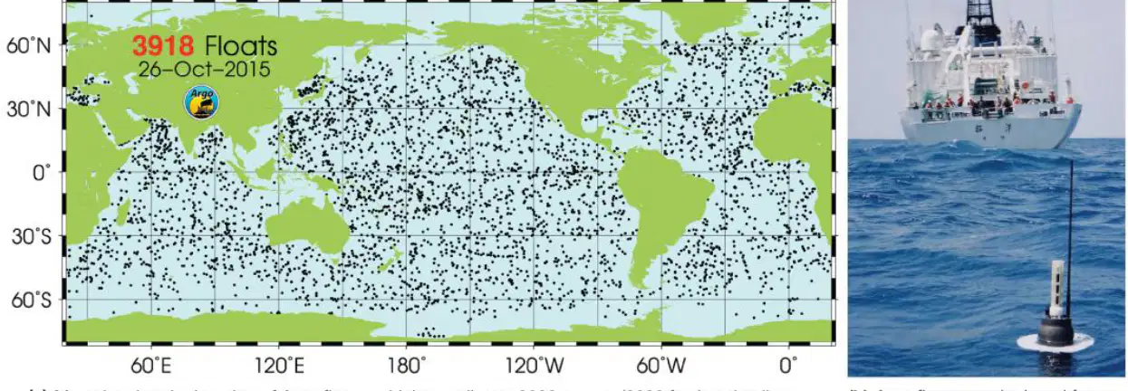
Explain how the global distribution of Argo floats, as shown in the map, contributes to our understanding of deep ocean currents.
Which layer of the ocean do surface currents occur above?
Thermocline
Pycnocline
Halocline
Deep ocean layer
What percentage of ocean water on Earth is affected by surface currents?
50%
25%
10%
75%
How much of the wind energy is transferred to the ocean surface to create surface currents?
10%
5%
2%
20%
Match the following reasons with why surface currents are slower than the corresponding winds.
Because of the Earth's rotation
Effect of Earth's rotation on ocean currents
Due to friction between wind and ocean surface
Frictional interaction between wind and ocean surface
Because of temperature differences
Influence of temperature on ocean movement
Due to salinity gradients
Impact of salinity on ocean currents
Match each surface current pattern with the factor it generally follows.
Oceanic salinity pattern
Pattern influenced by differences in salt concentration
Earth's wind belt pattern
Pattern influenced by global atmospheric circulation
Tidal pattern
Pattern influenced by the gravitational pull of the moon and sun
Seafloor topography pattern
Pattern influenced by underwater landforms
Explain how the interaction between wind and the ocean surface leads to the formation of surface currents, and why these currents do not move as fast as the wind itself.
Explain how the distribution of continents can affect the flow of surface currents in ocean basins.
Which combination of factors is responsible for influencing surface currents, according to the material?
Gravity, Friction, Coriolis effect
Temperature, Salinity, Wind
Sunlight, Pressure, Depth
Evaporation, Precipitation, Ice formation
What is the definition of a gyre?
Large, circular loops of moving water
Small, straight streams of water
Stationary pools of water
Rapidly rising columns of air
Subtropical gyres are centered at approximately (a) latitude.
Which of the following is NOT a boundary of subtropical gyres?
Equatorial current
Western Boundary currents
Polar ice caps
Eastern Boundary currents
The subtropical gyre found in the North Atlantic Ocean is called the (a) .
What is the name of the subtropical gyre located in the Indian Ocean?
Turtle Gyre
Majid Gyre
Columbus Gyre
Heyerdahl Gyre
Which direction do equatorial currents travel along the equator?
Eastward
Northward
Southward
Westward
Western boundary currents are typically found on the (a) of ocean basins.
What is a characteristic of western boundary currents?
They carry cold waters from polar regions
They carry warm waters from equatorial regions
They travel eastward along the equator
They are found in the center of ocean basins
Explain how the movement of equatorial currents and western boundary currents contributes to the distribution of warm water in the ocean.
Water flows across the ocean basin in Northern or Southern Boundary Currents in a (a) direction.
Northern boundary currents are found in the (a) .
What is a characteristic of Eastern Boundary Currents?
Warm waters
Cool waters
High salinity
Fast flow
Match the following types of ocean currents with the edge of the ocean basin where they are located.
Western edge
Western Boundary Currents
Northern edge
Northern Boundary Currents
Southern edge
Southern Boundary Currents
Eastern edge
Eastern Boundary Currents
Explain how the location of boundary currents differs between the Northern and Southern Hemispheres, and discuss the significance of these differences for ocean circulation.
What is the direction of flow of Equatorial Countercurrents?
Westward
Northward
Eastward
Southward
Equatorial Countercurrents occur at the equator due to (a) .
Match each type of ocean gyre with how it rotates.
In the same direction
How do subtropical gyres rotate compared to each other?
In the opposite direction
How do subpolar gyres rotate compared to subtropical gyres?
They do not rotate
How do gyres in the Sargasso Sea rotate?
Randomly
How do gyres rotate in unpredictable conditions?
Which statement best describes subpolar gyres?
They are larger and more numerous than subtropical gyres.
They rotate in the same direction as subtropical gyres.
They are smaller and fewer than subtropical gyres.
They are only found at the equator.
Explain how the Coriolis effect influences the formation of Equatorial Countercurrents and why this is significant for ocean circulation patterns.
Who developed the circulation model known as the Ekman spiral?
V. Walfrid Ekman
Albert Einstein
Isaac Newton
Charles Darwin
What does the Ekman spiral explain?
Match each scientific concept with its correct description.
It describes the direction and flow of surface waters at different depths
Ekman spiral
It explains the movement of tectonic plates
Plate tectonics
It details the process of volcanic eruptions
Volcanic eruption
It describes the water cycle
Water cycle
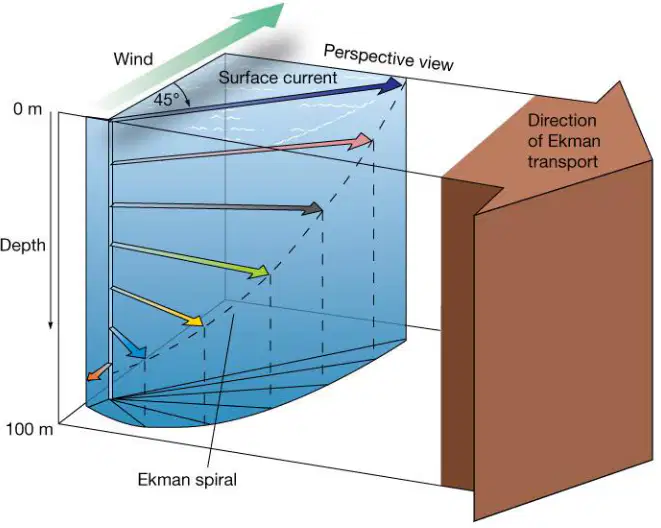
How does the Ekman spiral illustrate the effect of wind on surface water in the Northern Hemisphere?
Match the following terms with their correct descriptions related to oceanography.
The average movement of surface waters
Ekman transport
The movement of deep ocean currents
Thermohaline circulation
The process of evaporation from the ocean surface
Evaporation
The transfer of heat between ocean layers
Heat exchange between ocean layers
In which direction does Ekman transport move relative to the wind in the Northern Hemisphere?
90 degrees to the right
90 degrees to the left
Directly opposite to the wind
Parallel to the wind
In the Southern Hemisphere, Ekman transport moves:
90 degrees to the left of the wind direction
90 degrees to the right of the wind direction
Directly with the wind direction
Directly opposite to the wind direction
Why does Ekman transport result in a net movement of water at 90 degrees to the wind direction?
Because of the Coriolis effect acting on surface waters
Because of the gravitational pull of the moon
Because of temperature differences in the ocean
Because of the salinity gradient in the water
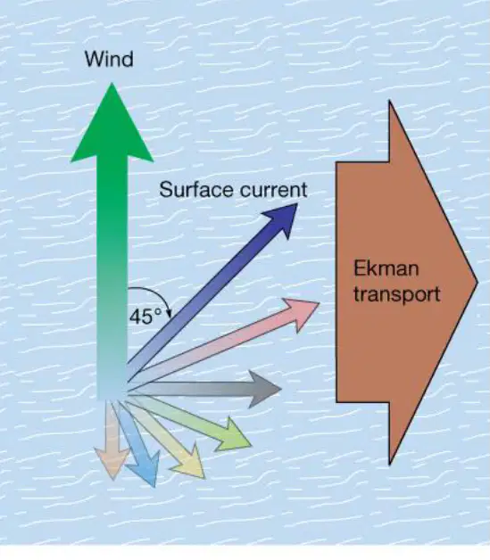
What does the diagram illustrate about the relationship between wind direction and Ekman transport?
What does Ekman transport generate in the ocean basin?
Linear flow
Rotational flow
Vertical flow
No flow
What is meant by "Subtropical Convergence" in the context of ocean currents?
The mixing of cold and warm water at the poles
The piling up of water in the middle of a gyre
The sinking of water at the equator
The movement of water along the coastlines
Explain how Ekman transport contributes to the formation of subtropical convergence in ocean gyres.
Match the following hemispheres or directions with the way surface water is deflected due to geostrophic currents.
To the right
Northern Hemisphere
To the left
Southern Hemisphere
Straight ahead
Along the equator
Downward
Vertical mixing
Match each cause with its effect on the deflection of surface water flow in geostrophic currents.
Coriolis effect
Deflects surface water flow due to Earth's rotation
Solar radiation
Heats the ocean surface, affecting temperature but not direct deflection
Tidal forces
Causes periodic rise and fall of sea level, not direct deflection
Wind only
Initiates movement of surface water but not the deflection in geostrophic currents
The flow of surface water in the Southern Hemisphere due to geostrophic currents is best described as being deflected to the (a) .
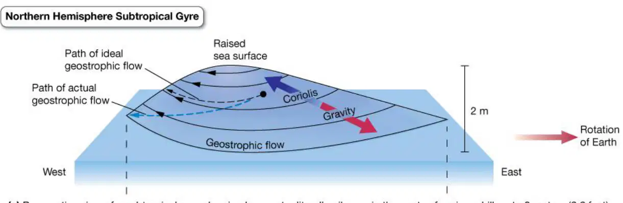
Explain how the balance between gravity and the Coriolis effect creates geostrophic flow in the ocean. Use evidence from the diagram to support your answer.
What is a geostrophic current?
A current that results from the balance of Coriolis effect and gravitational forces
A current caused only by wind
A current that moves in a straight line uphill
A current that is unaffected by gravity
Which of the following best describes the movement of a geostrophic current?
Moves in a circular path downhill
Moves in a straight line uphill
Moves randomly in all directions
Remains stationary
Why do geostrophic currents move in a circular path?
Due to the balance between the Coriolis effect and gravitational forces
Because of wind direction only
Due to temperature differences in the ocean
Because of the Earth's magnetic field
Which of the following is a direct result of Earth's rotation in relation to ocean water?
Top of hill of water displaced toward west
Top of hill of water displaced toward east
Water remains evenly distributed
Water moves only toward the poles
Which characteristics describe western boundary currents in both hemispheres?
Slower, wider, shallower, colder
Faster, narrower, deeper, warmer
Slower, narrower, deeper, colder
Faster, wider, shallower, warmer
Match the following effects with the phenomenon they contribute to in ocean currents.
Greenhouse effect
Contributes to global warming and sea level rise
Coriolis effect
Leads to western intensification in ocean currents
Tidal effect
Causes periodic rise and fall of sea levels
Solar effect
Drives surface heating and seasonal changes in ocean temperature
Explain how the Coriolis effect leads to the intensification of western boundary currents in both hemispheres.
On which side of ocean basins are Eastern Boundary Currents typically found?
Western side
Northern side
Eastern side
Southern side
Which of the following is NOT a typical property of Eastern Boundary Currents?
Cold
Fast
Shallow
Wide
Eastern Boundary Currents tend to have the opposite properties of which other type of ocean current?
Southern Boundary Currents
Northern Boundary Currents
Western Boundary Currents
Central Ocean Currents
A student claims that an ocean current is cold, slow, shallow, and wide. Based on these properties, what type of current is it most likely to be?
Western Boundary Current
Eastern Boundary Current
Equatorial Current
Deep Ocean Current
Explain why Eastern Boundary Currents are described as having the opposite properties of Western Boundary Currents. Use the characteristics listed to support your answer.
What effect do warm ocean currents have on the air at the coast?
They cool the air and make it dry
They warm the air and make it humid
They have no effect on the air
They make the air cold and humid
Which type of climate is typically found on landmasses adjoining cool ocean currents?
Humid climate
Dry climate
Tropical climate
Rainy climate
Explain how ocean currents can influence the climate of coastal regions. Use evidence from the information provided to support your answer.
What is upwelling in the context of ocean water movement?
Which process is associated with high biological productivity due to an abundance of algae at the base of the food web?
Downwelling
Upwelling
Evaporation
Precipitation
What is the main difference between upwelling and downwelling?
Explain how upwelling can impact the food web in marine environments.
What happens to surface waters in areas of diverging surface water?
Surface waters move away from the area.
Surface waters move toward the area.
Surface waters remain stationary.
Surface waters sink rapidly.
What is equatorial upwelling primarily caused by?
Convergence of currents at the equator
Divergence of currents at the equator
Increased evaporation at the equator
Decreased wind activity at the equator
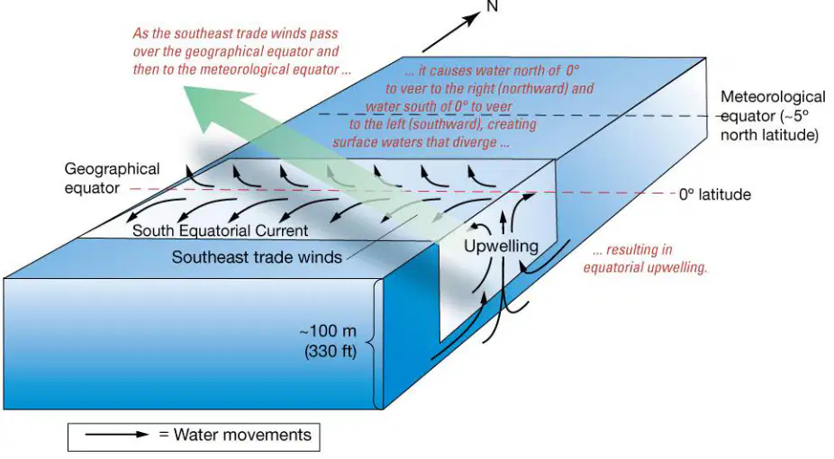
What is the role of southeast trade winds in equatorial upwelling as shown in the diagram?
How does the divergence of surface currents at the equator affect marine productivity?
It decreases productivity by reducing nutrient availability.
It increases productivity by bringing nutrients to the surface.
It has no effect on productivity.
It causes a decrease in water temperature, reducing productivity.
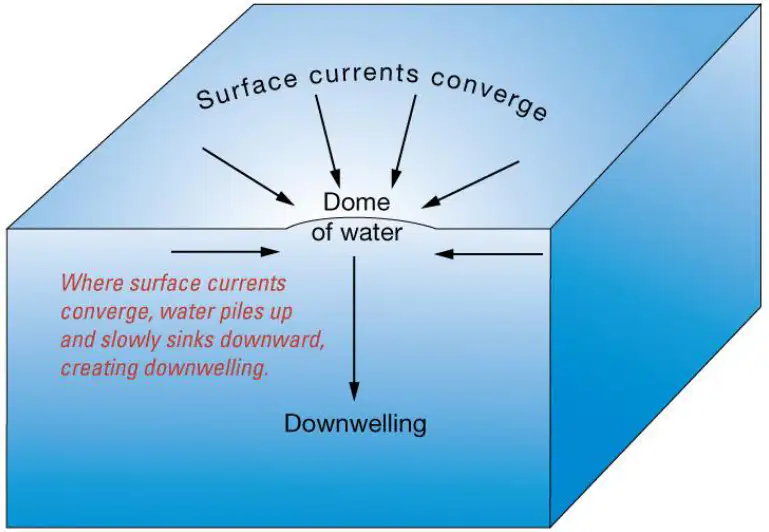
What happens when surface waters converge?
Surface waters move toward each other.
Surface waters move away from each other.
Surface waters remain stationary.
Surface waters evaporate quickly.
A consequence of water piling up due to converging surface currents is (a) .
How does converging surface water affect biological productivity?
It leads to low biological productivity.
It increases biological productivity.
It has no effect on biological productivity.
It causes rapid growth of marine life.
Explain why converging surface waters result in low biological productivity. Use evidence from the process described.
What is the primary process that moves surface seawater away from the shore during coastal upwelling?
Ekman transport
Tidal waves
Ocean currents
Wind erosion
Which type of water replaces the displaced surface waters during coastal upwelling?
Warm, nutrient-poor surface water
Cool, nutrient-rich deep water
Salty, shallow water
Polluted river water
How does coastal upwelling affect the temperatures in San Francisco?
It causes extremely hot temperatures
It leads to cool temperatures
It has no effect on temperatures
It causes frequent storms
Explain how Ekman transport contributes to the process of coastal upwelling and its impact on local climate, using evidence from the information provided.
Which of the following is NOT listed as a cause of upwelling in the provided material?
Offshore winds
Seafloor obstruction
High salinity
Coastal geometry change
What is a pycnocline, and why does its absence in high latitude oceans contribute to upwelling?
How can coastal geometry changes lead to upwelling?
By increasing the temperature of the water
By creating sharp bends in the coastline that redirect surface currents, causing deeper water to rise
By decreasing the salinity of the water
By flattening the seafloor
Which of the following diagrams would best represent upwelling caused by a seafloor obstruction?
A diagram showing wind blowing offshore and water rising near the coast
A diagram showing water flowing over a tablemount and rising upwards
A diagram showing a straight coastline with no features
A diagram showing only surface currents moving parallel to the coast
Which ocean is most affected by the El Niño weather event?
Atlantic
Indian
Pacific
Arctic
Complete the sentence: The ocean most affected by the El Niño weather event is the ______ Ocean.
Atlantic
Indian
Pacific
Arctic
Weather on the western edge of which continent is most likely to be affected by an El Nino event?
Africa
Australia
North America
Greenland
Two students are studying a map of the United States that shows July temperatures averaged over a ten-year period. One notices that cities on the East Coast have warmer temperatures than cities at similar latitudes on the West Coast. Which of the following is responsible for the difference?
El Niño brings rain and cool weather to the West Coast but does not affect the East Coast as much.
The Pacific Ocean is larger and deeper than the Atlantic Ocean and is, therefore, colder than the Atlantic Ocean.
Ocean currents from the Tropical Atlantic warm the East Coast, while currents from the Northern Pacific cool the West Coast.
During the summer, the East Coast is often hit by hurricanes, which bring warm air as they move along the coast.

What type of weather system would be controlling this weather map?
A. A low pressure system that is pulling moisture off of the gulf.
B. A high pressure system that is pushing the moisture away from the area.
C. A cold front that is bringing in cooler air from the south.
D. A warm front that is bringing in warmer air from the west.
Because of the tilt of Earth's rotation, wind/air moves to the right in the Northern Hemisphere. It moves to the left in Southern Hemisphere. Imagine driving in a car leaving the Equator heading straight north. Your car would be push to right if it were air/wind. If you were leaving poles and headed towards the equator, your car would be heading to right also. But remember you are heading from North to South now. So even though you are being pushed to the right your now being push towards the west because going south. When you were driving North, you were being push towards East. It is the opposite in the SOUTHERN HEMISPHERE air and wind is pushed to left in same manner. This is all called
The air pressure of the Polars and The Equator play a role in wind. Low pressure or High pressure is at Equator?
Why is there low pressure at Equator?
There are some winds that flow toward Equator. These winds will be pushed to the right from the 30 N latitude to 30 South Latitude. That means they are going from East to West. What are these winds called?
Trade winds play a part in El Nino and La Nino. In El Nino what happens to these winds?
Because these trade winds weaken during El Nino, what happens to the Pacific Jet Stream?
The Pacific Jet Stream becomes more variable and often stronger. It shifts more south as the trade winds lose strength
Jet streams move from (a) .
During La Nina, the winds strengthen instead of weakening like El Nino. What does this do to the jet stream?
The jet stream shifts more towards the north.
So when La Nina is making the Trade Winds get stronger, there is more surface area water being pushed to the West. So the water in the Pacific nearer the West Coast of California now has water rising from the bottom that is more (a)
During El Nino, the winds are not as strong. They are not being pushed to the West as hard or even pushed to the East. This means that surface water which is warmer on top, stays or moves more to East. So the water in the Pacific near California is (a) than it normally would be.
Match the following weather conditions in the Southern US with the corresponding climate events.
Stable and dry conditions.
Typical conditions during La Nina.
Hot and humid conditions.
Typical conditions during a heat wave.
Wetter and cooler conditions.
Typical conditions during El Nino.
Drier and warmer conditions.
Typical conditions during a drought.
During La Nina, weather conditions in the Southern United States are typically (a) .

The curving of wind across our earth is called the Coriolis Effect. It is caused by
(a)

The Coriolis Effect causes which two things to curve sideways?
weather and climate
wind and ocean currents
rain and snow
temperatures

In the Northern Hemisphere, the Coriolis Effect causes air to move to the (a) .
During a(n) ____ event, trade winds are much stronger than usual.
El Nino
La Nina
Normal
Partly sunny
During an El Nino, it rains
in the central Pacific
in the FAR eastern Pacific
in the western Pacific
In all of the Pacific
Both El Nino and La Nina have (a) in common.
During an El Nino, trade winds are typically...
about average
stronger
weaker

The image is of a(n):
El Nino event
La Nina event
Non-El Nino (normal conditions)

The picture below is of a(n) ____ event.
Non-El Nino (Normal)
El Nino
La Nina

The picture represents a(n) ___ event.
El Nino
La Nina
Non-El Nino (normal conditions)
La Niña is characterized by ______________ of the Western Pacific Ocean.
a warming
a cooling
average temperatures
El Niño ___________________ the trade winds causing the warm pool to move ___________.
weakens or reverses; west
intensifies; west
weakens or reverses; east
intensifies; east
What impacts does El Nino have on the environment and society?
Warms the sea surface temps in Pacific ocean
Increased rainfall in southern united States and peru
drier conditions in Australia and Indonesia.
Improves marine ecosystems.
El Niño occurs when the tropical ocean waters are warmer in the (a) ocean.

What weather pattern is this a picture of?
La Nina
Normal weather
El Nino
La Tia
La Nina is characterized by cooler-than-average sea surface temperatures, in the central and eastern Pacific ocean. This statement is (a) .
During __________ surface temperatures in the eastern Pacific are colder than average.
El Nino
La Nina
What regions are affected by El Nino?
Southern United States
Peru and Western South America
Central and Eastern Pacific ocean
Australia and Indonesia
What regions are affected by la Nina?
Africa
Latin America
South and South-East Africa
America
El Nino occurs every 2 to 7 years is (a) .
True or false?
La Nina occurs every 3 to 5 years
True
False
What is the primary cause of El Nino?
Changes in the Earth's orbit
Variations in solar radiation
Weakening of trade winds
Volcanic eruptions
Which of the following is a typical effect of La Nina on global weather patterns?
Increased hurricanes in the Atlantic
Warmer winters in Canada
Droughts in the Amazon
Increased rainfall in Southeast Asia
El Nino affects marine life in the Pacific Ocean by (a) .
During an El Nino event, the change that occurs in the atmospheric pressure across the Pacific Ocean is (a) .
What is a common method used by scientists to predict El Nino events?
Studying sunspot activity
Monitoring sea surface temperatures
Analyzing volcanic activity
Observing polar ice cap melting
Match the following climatic phenomena with their impact on the Indian monsoon:
Weakens the monsoon
El Nino
Strengthens the monsoon
La Nina
No impact on the monsoon
Neutral ENSO conditions
Delays the monsoon
Indian Ocean Dipole (negative phase)

Match the following descriptions of El Niño and La Niña with their effects on local weather.
El Nino creates cool currents and results in a cooler winter for the southern half of the US while La Nina creates warm currents and results in a warmer winter for the southern US
El Niño creates cool currents and results in a cooler winter for the southern half of the US, while La Niña creates warm currents and results in a warmer winter for the southern US.
El Nino creates warm ocean currents which results in warmer winters for all of the US, and La Nina creates cool ocean currents which leads to cooler winters for all of the US
El Niño creates warm ocean currents which results in warmer winters for all of the US, and La Niña creates cool ocean currents which leads to cooler winters for all of the US.
El Nino creates warm ocean currents which results in cooler winters for the southern half of the US while La Nina creates cooler ocean currents which results in a warmer winter in the southern half of the US
El Niño creates warm ocean currents which results in cooler winters for the southern half of the US, while La Niña creates cooler ocean currents which results in a warmer winter in the southern half of the US.
El Nino and La Nina are ocean currents and change water temperatures, but do affect local weather
El Niño and La Niña are ocean currents and change water temperatures, but do affect local weather.
Which of the following is true regarding El Nino?
It is a destructive hurricane
It is comprised of ocean currents from the Caribbean
It is caused by weakening trade winds
It only occurs in the Southern Hemisphere
What is the cause of rising surface temperatures of the Pacific Ocean, drought in the western US, and flooding along the Pacific coast of South America?
the Gulf Stream
La Nina
the Jet Stream
El Nino
What is the effect of El Nino on both Pacific hurricanes (Typhoons) and Atlantic hurricanes
Does NOT influences hurricane development, resulting in more eastrn Pacific hurricanes and fewer Atlantic hurricanes
Influences hurricane development, resulting in more eastern Pacific hurricanes and fewer Atlantic hurricanes
Influences hurricane development, resulting in less eastern pacific hurricanes and fewer Atlantic hurricanes
What do you call winds that blow in the same direction all over the Earth and influence marine travel?
Corolis effect
Trade Winds
Greenhouse effect
sea breezes
A result of upwelling is a/an ______ in nutrients in the water.
Decrease
Increase
No Change
What are some regions most affected by El Nino?
Africa
Antarctica
South America, Australia, Southeast Asia
Europe
What is the opposite phenomenon of El Nino?
La Nina
El Verano
El Sol
El Viento
Which ocean is primarily associated with the occurrence of El Nino?
Indian Ocean
Arctic Ocean
Atlantic Ocean
Pacific Ocean

The picture represents a(n) ___ event.
El Nino
La Nina
Non-El Nino (normal conditions)
Match the following descriptions of climate events with their correct names.
Non-El Nino (Normal)
Warm water and increased rainfall shift eastward toward South America in the Pacific Ocean.
El Nino
Typical trade winds push warm water westward, keeping rainfall near Australia and Indonesia.
La Nina
Stronger than normal trade winds push warm water further west, causing cooler water near South America and increased rainfall in the western Pacific.
Match the following climate events with their typical rainfall patterns in the Pacific Ocean.
El Nino event
Increased rainfall in the central and eastern Pacific
La Nina event
Increased rainfall in the western Pacific and drier conditions in the east
Non-El Nino (normal conditions)
Rainfall patterns are near average across the Pacific
Why do the fisherman of Peru and South America not welcome a strong El Nino?
El Nino poisons the fish
El Nino causes strong winds and currents which move fish westward
El Nino bring cold water to the surface which kills the base of the food chain
El Nino shuts off upwelling and nutrients needed for the marine food chain do not rise to the surface
The Coriolis effect causes ___________.
global winds and water to move in a curved path instead of a straight line
continental deflection
the Earth to rotate on its axis
the orbit Earth takes around the sun
What is the main cause of the Coriolis Effect?
earth’s rotation
trade winds
temperature
the sun and ocean
Air always wants to move from areas of ______________ pressure to _______________ pressure.
low to high
high to low
doesn't matter
huh?
The highest pressure on Earth is found here due to the amount of cold sinking air.
poles
30 degree latitude
60 degree latitude
equator
What causes wind?
movement of air from high pressure to low pressure
movement of air from low pressure to high pressure
Which object REFLECTS the most energy from the Sun?
Rocks
Plants
Snow
Animals
Some effects of global winds and convection currents in the atmosphere include (a) .
Check all that apply:
what are the convection current cell names that create our global winds? Caused by the unequal heating of the earth.
Hadley Cell
Ferrel Cell / Mid-Latitude Cell
Abiotic Cell
Polar Cell
Why do Australia and China have opposite seasons?
They are both in the northern hemisphere
They are both in the southern hemisphere
They are in opposite hemispheres
They are both in the western hemisphere
Why are tropical rainforests found near the equator?
Because warm air rises, cools & condenses to bring rain.
Because cold air condenses and brings rain.
Because warm air rises, dries out & condenses to bring rain.
Because cool air rises & dries out.
What biome is typically located at latitudes 30 degrees North & South of the equator?
Tropical rainforest
Tundras
Desert
Temperate grasslands
Match the following factors with their influence on ocean currents.
Wind patterns
Causes surface currents to move in specific directions
The Sun
Provides energy that drives atmospheric and oceanic circulation
Earth's rotation
Causes the Coriolis effect, influencing current direction
A temperature gradient in the ocean
Causes differences in water density, affecting current flow
Match the following methods with their primary heat transfer processes in ocean currents.
Conduction
Heat transfer through direct contact of molecules
Radiation
Transfer of energy through electromagnetic waves
Convection
Movement of heat through fluid motion
Evaporation
Process involving the change of state from liquid to gas
Which current is known for transporting warm water from the Caribbean to the North Atlantic?
Labrador Current
California Current
Gulf Stream
Humboldt Current
The term for the boundary between two different water masses in the ocean is (a)
Sea surface temperatures generally (a) from the equator to the poles.
Which of the following best describes the relationship between wind and surface currents?
Wind has no effect on surface currents
Wind pushes against surface currents, slowing them down
Wind helps drive surface currents in the same general direction
Wind and surface currents always move in opposite directions
Which best explains how the Gulf Stream affects the movement of hurricanes in the Atlantic Ocean?
The Gulf Stream moves warm water and hurricanes from south to north.
The Gulf Stream moves warm water and hurricanes from north to south.
The Gulf Stream moves warm water and hurricanes from east to west.
The Gulf Stream moves warm water and hurricanes from west to east.
Match the following
rip tide
strong, narrow currents along the coast
upwelling
upward movement of cold water
Coriolis effect
deflection of moving objects due to spin
Great Conveyer Belt
global system of ocean currents
How do ocean fronts affect marine life?
They act as barriers preventing animal movement
They are areas where food often collects, attracting animals
They have no significant impact on marine life
They cause marine animals to avoid the area

