Worksheets
Geography Skills Quiz
Total questions: 70
Worksheet time: 1hrs 22mins








The country located at 60 degrees North, 120 degrees West is
Canada
Alaska
USA
Mexico

Location H is located at which coordinates?
60oN, 120oE
90oN, 30oE
10oS, 40oW
30oN, 90oE
Which is the largest park in the Rocky Mountains of Alberta?
Banff
Elk Island
Wood Buffalo
Jasper
This National Park is in the Canadian shield.
Jasper National Park
Elk Island National Park
Waterton National Park
Wood Buffalo National Park
It was first a fur trading post in 1813. It became a national park in 1907 and had the railway go through it by 1911
Banff National Park
Jasper National Park
Waterton National Park
Dinosaur Provincial Park
This is Canada’s first national park established in 1855 and it is the most visited in Western Canada.
Jasper National Park
Dinosaur Provincial Park
Elk Island National Park
Banff National Park
It was started in 1906 to protect a herd of elk. At the time that small herd was one of the last in Canada! In 1907 bison were brought to the park as well.
Waterton National Park
Dinosaur Provincial Park
Elk Island National Park
Wood Buffalo National Park
This National Park is part of the traditional territory and a place of significance for the Blackfoot and other Indigenous peoples in Southern Alberta.
Waterton National Park
Banff National Park
Jasper National Park
Wood Buffalo National Park
Designated a UNESCO World Heritage site, it is home to free-roaming wood bison herds, the nesting habitat for endangered whooping cranes, and the world’s largest beaver dam.
Elk Island Nation Park
Wood Buffalo Nation Park
Jasper Nation Park
Dinosaur Provincial Park
This park contains some of the most important fossil specimens discovered
Jasper National Park
Banff National Park
Dinosaur Provincial Park
Waterton National Park
Why do we have protected areas?
To protect the people that live there.
So the Canadian and Albertan government can make money.
So people can enjoy the landscape, wildlife and plants.
To protect the campgrounds.
What are national parks?
They are owned and managed by the Alberta government.
They are owned and managed by the people who live there.
They are owned and managed by wildlife officers.
They are owned and managed by the Canadian government.

What is the grid reference for point A?
345135
355345
135345
What are the reference numbers that appear first in a grid reference?
Northings
Eastlings
Northlings
Eastings
The horizontal lines in a grid are known as...
Eastings
Northings

What point is located at 176322?
B
D
C
A

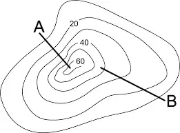
What is the interval of the above contour map?
10 meters
5 meters
1 meter
20 meters

What is the height of point Y?
30 meters
29 meters
30 meters above sea level
29 meters above sea level

Which side of the landform is steeper
North
East
South
West

Is the spot height shown on the contour map?
Yes
No

What is the location of the Hospital?
(a)

What is the 6 digit military grid reference for the School.
724325
325773
326732
732325
Which of the following uses words to describe the relationship between a distance on a map and a specific distance on Earth's surface?
Line Scale
Marking Scale
Representative Fraction Scale
Direct Statement
Which of the following uses a special kind of ruler that is divided into units of distance?
A direct statement scale
A Line Scale
A Representative Fraction Scale
A Marker Scale
Which of the following best represents a ratio where 1 unit on the map represents a certain number of the same units on the Earth's surface?
A Representative Fraction Scale
A Line Scale
A Marker Scale
A Direct Statement Scale
How many kilometers does 1000000 cm represent?
(a)


What is elevation?
Height
An elevator
The width

The distance between contour lines is called...
Contour interval
Contour line
Colors
Mountains
The steepness or flatness of Earth's Surface
Topography
Topographic Map
Contour Lines
Contour interval
A map that shows the surface features of Earth
Road Map
Topographic map
water map
hybrid map


1 m = __________ cm
10
100
1000
100 000
1km = ___________ m
10
100
1000
100 000
1km = _______________ cm
10
100
1000
100 000
The scale of a street map is 1 : 5000.
Find the actual distance, in metres,
for 4 cm on the map.
0.2
2
20
200

What type of map is this?
Political Map
Physical Map
Demographic Map
Ozone Map

What tool on a map shows you the directions?
scale
key
legend
compass rose

What type of map is this?
political map
physical map
Mercator Map
Robinson Map
What tool helps you compare sizes of models to real objects?
scale
distortion
compass rose
key
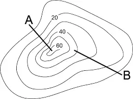
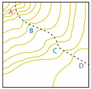

Which hill is steeper?
A
B