
 Worksheets
TRẮC ĐỊA
Total questions: 71
Worksheet time: 36mins
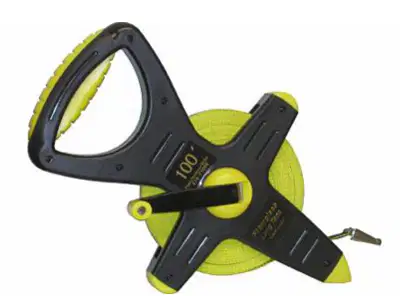
What is this ?
a. Odometer
b. Leveling
c. Steel Tape
d. all is incorrect
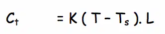
What is this equation ?
a. Temperature Correction
b. Tension Correction
c. Sag Correction
d. all is incorrect
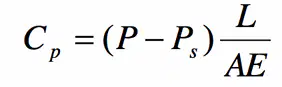
What is this equation ?
a. Temperature Correction
b. Tension Correction
d. all is incorrect
c. Sag Correction
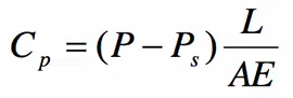
From Equation, the value A is …..
a. the measure distance
b. Cross sectional area of tape
c. the weight of tape
d. all is incorrect

From Equation, the value T …..
a. the field temperature
b. the standard temperature
c. the tension force
d. all is incorrect
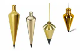
What is this?
a. the plumb bobs
b. the tape
c. the handle tension
d. all is incorrect
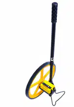
What is this?
a. the tape
b. the odometer
c. the handle tension
d. all is incorrect
Measurement of the distance by ……
a. the Tape
b. the Odometer
c. the Pacing
d. all is correct

What is this?
a. the rod
b. the odometer
c. the handle tension
d. all is incorrect
What is the unit of distance?
a. m
b. ft
c. km
d. all is incorrect
What is the Leveling?
a. leveling is a process of finding elevations of points.
b. leveling is a process of finding elevations of lines.
c. leveling is a process of finding elevations of pictures.
d. leveling is a process of finding elevations of angles.
Control of elevations is very ………. in a variety of jobs
a. important
b. inessential
c. not absolutely necessary
d. all is incorrect
mean sea level is
a. The level surface of the sea
b. The level surface of the ground
c. The level surface of the moutain
d. all is incorrect
4. (0.15 points) Elevation is
a. The distance measured along a vertical line from a vertical datum to a point or object
b. The distance measured along a horizontal line from a vertical datum to a point or object
c. The distance measured along a vertical line from a vertical ground surface to a point or object
d. all is incorrect
Methods of Leveling is
a. Measuring the vertical distance by taping
b. Barometric Leveling
c. Differential Leveling
d. All is correct
What is the Benchmark (BM)?
a. Benchmark is a relatively permanent point of known elevation.
b. Benchmark is a relatively permanent point of unknown elevation.
c. Benchmark is a chair.
d. all is correct
What is the Turning point?
a. Turning point is a station along a survey that is established as a temporary benchmark
b. Turning point is a station along a survey that is established as a permanent benchmark
c. Turning point is a Clock wise
d. all is correct
What is the Back Sight (BS) ?
a. Back Sight is a sight taken to the level rod held on a point of known elevation
b. Back Sight is a sight taken to the level rod held on a point of unknown elevation
c. Back Sight is a looking to the landscape
d. all is correct
What is the Fore Sight (FS)?
a. Fore Sight is a rod reading taken on a point of unknown elevation
b. Fore Sight is a rod reading taken on a point of known elevation
c. Fore Sight is a camera taken on a picture
d. all is correct
What is the true about “Level Loop Adjustments”
a. the error in a level loop is unacceptable, the leveling must be repeated
b. the error in a level loop is acceptable, that error is distributed according to the distances leveled (or the number of instrument setups).
c. All is correct
What is the Horizontal angles?
a. Rotating along horizontal plane.
b. Rotating along vertical plane.
c. Rotating along elavation plane.
d. all is correct
What is Instrument for measuring angles?
a. theodolite
b. taping
c. leveling
d. all is correct
Unit of Angle Measurement ?
a. Degree (60 minutes), minute (60seconds), second
b. Grade (%)
d. all is correct
c. Radiant
What is the Azimuth?
a. Azimuths range in magnitude from 0 to 360 degree.
b. Azimuths range in magnitude from 0 to 180 degree.
c. Azimuths range in magnitude from 0 to 90 degree.
d. all is incorrect
Bearings are ………?
a. less than 90 degree
b. less than 180 degree
c. 0
d. all is incorrect
What is the Vertical angles?
a. Rotating along horizontal plane.
b. Rotating along vertical plane.
c. Rotating along elevation plane.
d. all is correct
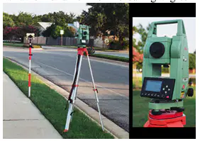
2. (0.15 points) What is Instrument for measuring angles in the picture?
a. Total station
b. theodolite
c. leveling
d. all is incorrect
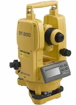
What is Instrument for measuring angles?
a. Total station
b. theodolite
c. leveling
d. all is incorrect

This equation is used to …..
a. Closed Traverse
b. Open Traverse
c. Open Traverse and Closed Traverse
d. all is incorrect
Deflection angles have in the ……
a. Open Traverse
b. Closed Traverse
c. Open Traverse and Closed Traverse
d. all is incorrect
Open Traverse …….
a. using interior angles.
b. using deflection angles.
c. using interior and deflection angles.
d. all is incorrect
Closed Traverse …….
a. using interior angles.
b. using deflection angles.
c. using interior and deflection angles.
d. all is incorrect
What is types of traverse?
a. Open Traverse .
b. Drive Traverse.
c. Cut Traverse.
d. all is correct.
4. (0.15 points) “It is a series of measured straight lines and angles that do not geometrically close”
a. It is open Traverse.
b. It is closed Traverse.
c. It is control station.
d. all is correct.
“It begins and ends at the same station whose position is known”
a. It is Open Traverse.
b. It is closed Traverse.
c. It is control station.
d. all is correct.
When do you need Balancing Angles?
a. Misclosure Error >0.
b. Not Error.
c. Misclosure Error = 0
d. all is correct.
Location of a Point by x, y is ……
a. rectangular coordinates
b. polar coordinate
c. radian coordinate
d. all is correct.
Location of a Point by (r,q) is ……
a. rectangular coordinates
b. polar coordinate
c. triangle coordinate
d. all is correct.
Latitude (AB) =
a. distance(AB) * cos(azimuth of AB)
b. distance(AB) * sin(azimuth of AB)
c. distance(AB) * tan(azimuth of AB)
d. all is correct.
Departure (AB) =
a. distance(AB) * cos(azimuth of AB)
b. distance(AB) * sin(azimuth of AB)
c. distance(AB) * tan(azimuth of AB)
d. all is correct.
Azimuth of the line AB is
a. clockwise angle between AB and North
b. counterclockwise ngle between AB and North
c. clockwise angle between AB and South
d. all is correct.
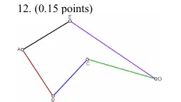
This is ……
a. closed Traverse
b. open Traverse
c. five points
d. all is correct.

…… is
a. Forward azimuth
b. Forward bearing
c. Backward azimuth
d. Backward bearing
Bearing of AB is N30W, then Bearing of BA is …….. (with 30 is degree).
a. S30E
b. N30E
c. S30W
d. all is incorrect.
What is true about Bearing?
a. Bearings are less than 90 degree.
b. Bearings are less than 180 degree.
c. Bearings are less than 360 degree.
d. all is incorrect.
What is true about Azimuth?
a. Azimuth is from 0 to 360 degree.
b. Azimuth is from 0 to 180 degree.
c. Azimuth is from 0 to 90 degree.
d. all is incorrect.
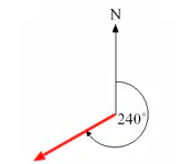
ĐÂY LÀ CÁI GÌ ĐỐ BIẾT ĐÓ:))
a. Azimuth is 240 degree
b. Bearing is 240 degree
c. Azimuth is 240 radian
d. all is incorrect.
The closed traverse if ….
a. Sum(latitudes)=0 and Sum(Departure)=0
b. Sum(Azimuths)=0 and Sum(Bearing)=0
c. Sum(latitudes)>0 and Sum(Departure)>0
d. all is incorrect.
Compass Rule is
a. Traverse Adjustment
b. Traverse Calculation
c. draw the line
d. all is incorrect
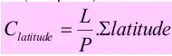
P is
a. People
b. Total length of traverse
c. Point
d. all is incorrect
Perimeter of closed traverse is
a. Total length of traverse
b. Sum all distance of traverse
c. Length from begin station to end station
d. all is correct
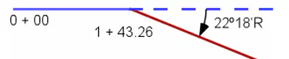
What is this angle?
a. This is deflection angle
b. This is internal angle
c. This is external angle
d. all is correct
Bearing = Azimuth when the line in ……
a. NE quadrant
b. SE quadrant
c. SW quadrant
d. all is incorrect
Why do you need calculate the Azimuth?
a. find a line
b. find a angle
c. find a direction
d. all is incorrect
A closed traverse have six stations, then sum of interior angle is……degree.
a. 360
b. 540
c. 180
d. all is incorrect
A open traverse have five stations, then sum of interior angle is……degree.
a. 360
b. 540
c. 180
d. all is incorrect
In survey, GPS is.……
a. Global Positioning System
b. Global Policy Strategy
c. Global Power System
d. all is incorrect
2. (0.15 points) What is instrument must to use in Global Positioning System?
a. Satellite
b. Taping
c. Leveling
d. all is incorrect
…… are lines that connect points of equal elevation
a. Contours
b. Curves
c. Roads
d. all is incorrect
What is Drawing size?
a. A1
b. A2
c. A3
d. all is correct
In survey, GIS is.……
a. Global Internet System
b. Geographic Information System
c. Global International System
d. all is incorrect
Contours deflect ………..at valley lines
a. uphill
b. downhill
c. straight
d. all is incorrect
Contours deflect ……….. at ridge lines
a. uphill
b. downhill
c. straight
d. all is incorrect
What is the method of Area Computation ?
a. Coordinate Method
b. Trapezoidal Method
c. Simpson’s One-third Rule
d. all is correct

What is the method of Area Computation ?
a. Coordinate Method
b. Trapezoidal Method
c. Simpson’s One-third Rule
d. all is correct

What is the method of Area Computation ?
a. Coordinate Method
b. Trapezoidal Method
c. Simpson’s One-third Rule
d. all is correct
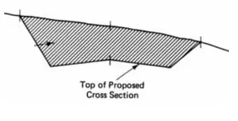
What is the type of area?
a. Cut area
b. Fill area
c. Cut and Fill area
d. all is correct
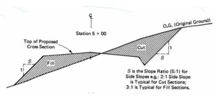
What is the type of area?
a. Cut area
b. Fill area
c. Cut and Fill area
d. all is correct
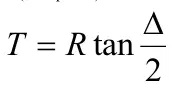
R is ….?
a. Radius of curve
b. Radian of curve
c. Round of curve
d. all is incorrect
Highway Design use the …… angle of line.
a. deflection
b. internal
c. interior
d. all is incorrect
3. (0.15 points) Highway Design have the ……..
a. horizontal curve
b. vertical curve
c. straight line
d. all is correct

