
 Worksheets
MIDTERM EXAM: FAR4106 - PLANNING 3
Total questions: 50
Worksheet time: 25mins
The following are the definitions of Ekistics, EXCEPT.
a systematic approach to understanding and designing human settlements, integrating diverse fields like urban planning, sociology, economics, and environmental science.
a multidisciplinary field that focuses on the development and management of urban and regional areas.
seeks to create a harmonious relationship between people and their surroundings, focusing on how settlements can enhance human well-being and functionality.
the core goal is to design environments that support human happiness, social interaction, and efficient daily life for all inhabitants.
He was admired as the "father of Ekistics," a new science dedicated to human settlements, uniquely blending architecture, sociology, and technology
Ernest Burgess
Constantinos A. Doxiadis
Charles-Edouard Jeanneret
Don Arturo Soria y Mata
A hierarchical classification of settlements, ranging from the smallest unit to the largest possible global city, illustrating the concept of human settlements on scale of population and area.
Hierarchy and linkages of Plans
Rank Size Rule Theory
Ekistic Logarithmic Scale
The arrangement of a built-up area
Based on the hierarchical classification of settlements, it was considered as the ultimate "world city" concept, where all of humanity lives within one interconnected global urban network.
Eperopolis
Megalopolis
Ecumenopolis
Metropolis
Based on the hierarchical classification of settlements, considered as The smallest unit, also known as the human being.
Anthropos
Room
House
Hamlet
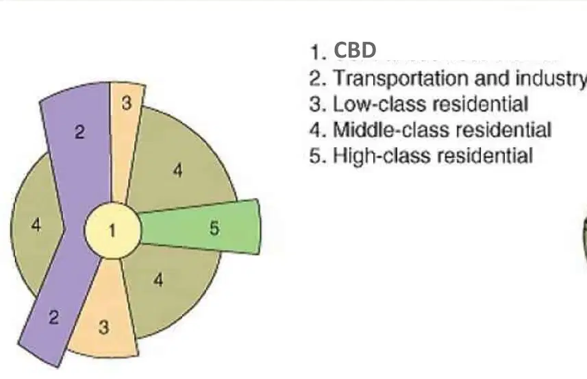
According to the Sector theory,
which is true about high-class residential areas?
They are located only in the CBD
This area is clean, has less traffic, quiet and has large houses
They are densely populated
They are always next to industrial areas
Which theory suggests that cities have multiple growth points or 'nuclei'?
Concentric Zone Theory
Multiple Nuclei Theory
Sector Theory
Linear Urban Form
In the classical theories of urban structure, what does CBD stand for?
Central Business District
Central Building District
Central Banking District
Central Broadcasting District
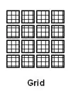
What is a disadvantage of the grid urban form?
Difficulty in accessibility
High development cost
Conflict of movement due to Intersections
Complex layout
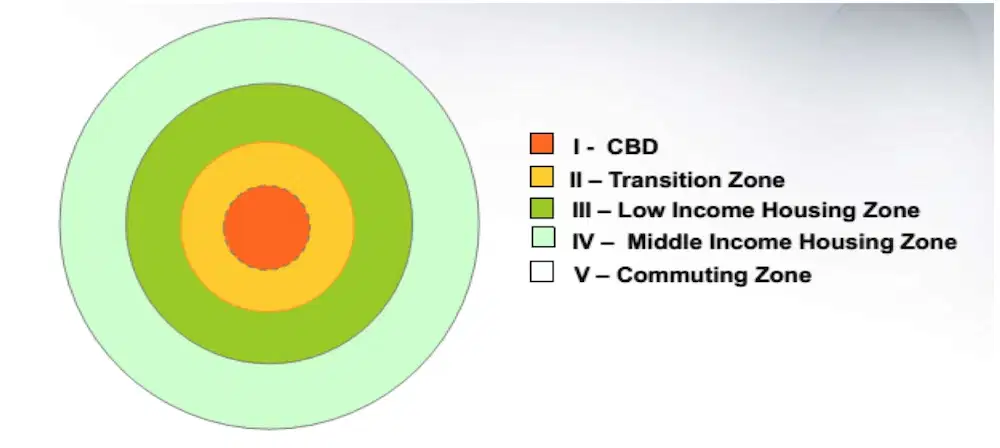
What does the concentric zone model describe?
Linear urban structures
Industries surrounding residential areas
Sectors based on house age
Different socio-economic groups located at varying distances from CBD
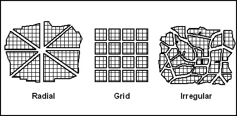
It is the arrangement of a built-up area. This arrangement is made up of many components including how close buildings and uses are together; what uses are located where; and how much of the natural environment is a part of the built-up area.
Urban Form
Urban Structure
Urban Theory
Urban Sprawl
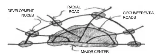
Identify the Urban Form as shown on the image.
Radial and Circumferential
Axial or Urban Star
Concentric or Compact Urban Form
Galaxy of Settlements
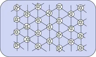
Identify the Urban Form as shown on the image.
Radial and Circumferential
Axial or Urban Star
Concentric or Compact Urban Form
Galaxy of Settlements
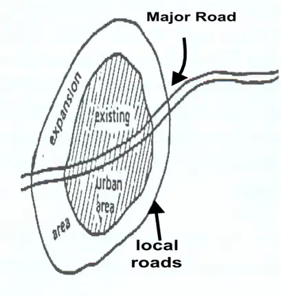
Identify the Urban Form as shown on the image.
Radial and Circumferential
Axial or Urban Star
Concentric or Compact Urban Form
Galaxy of Settlements
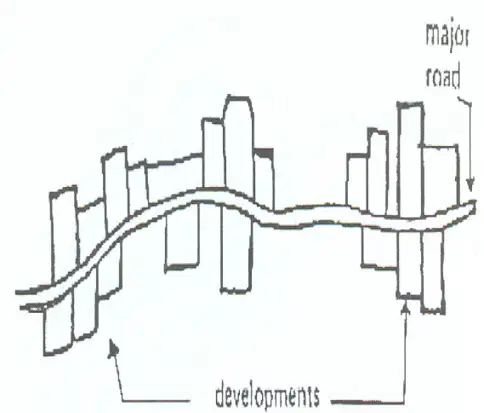
Identify the Urban Form as shown on the image.
Linear Urban Form
Grid Urban Form
Dispersed (Amorphic Sprawl)
Galaxy of Settlements
Enumerate the The Five Elements of Ekistics:
Nature, Man, Society, Shells, Networks
Earth, Water, Fire, Air, Space
Planning, Design, Construction, Maintenance, Demolition
Culture, Economy, Technology, Politics, Religion
Elements of Ekistics defined as the physical structures and
buildings that house human activities, from homes to public spaces
Nature,
Man
Shell
Networks
Elements of Ekistics defined as the interconnected systems of infrastructure:
roads, utilities, communication, and transportation.
Nature,
Man
Shell
Networks
Elements of Ekistics defined as the human individual,
their physical, psychological, and social
needs at the core of all planning
Nature,
Man
Shell
Networks
Elements of Ekistics defined as the ecological context and natural
environment of a settlement, its resources and constraints.
Nature,
Man
Shell
Networks
Government's plan that guides the planning and management of the country's land and other physical resources at the national and sub-national levels, should be the reference point by which subsequent national and local sectoral or development plans are directly linked and aligned.
Provincial Dev't & Physical Framework Plans
Regional Physical Framework Plans
National Physical Framework Plans
Comprehensive Land Use Plans
Plans that shall determine the physical development of the entire provincial territory, consolidate and harmonize the comprehensive land use plans of component cities and municipalities.
Provincial Dev't & Physical Framework Plans
Regional Physical Framework Plans
National Physical Framework Plans
Comprehensive Land Use Plans
Plans shall serve as basis for other sectoral and development plans related to land, natural resources, and infrastructure facilities, including the development plan of the province.
Provincial Dev't & Physical Framework Plans
Regional Physical Framework Plans
National Physical Framework Plans
Comprehensive Land Use Plans
Shall determine the specific uses of land and other physical and natural resources, both private and public, within territorial jurisdiction including areas co-managed with the national government and, as appropriate, management plans for ancestral domains, critical watersheds, river basins, and protected areas.
Provincial Dev't & Physical Framework Plans
Regional Physical Framework Plans
National Physical Framework Plans
Comprehensive Land Use Plans
Under Section 20, the local government units shall, in conformity with existing laws, continue to prepare their respective comprehensive land use plans enacted through zoning ordinances which shall be the primary and dominant bases for the future use of land resources; Provided, that the requirements for food production, human settlements, and industrial expansion shall be taken into consideration in the preparation of such plans.
RA 7160 - Local Government Code of 1991
RA 7279 - Urban Development and Housing Act
RA 10121 - National Disaster Risk Reduction and Management
RA 9729 - Climate Change Act of 2009
Act declares to mainstream disaster risk reduction and climate change in development processes such as policy formulation, socioeconomic development planning, budgeting, and governance, particularly in the areas of environment, agriculture, water, energy, health, education, poverty reduction, land use and urban planning, and public infrastructure and housing, among others.
RA 7160 - Local Government Code of 1991
RA 7279 - Urban Development and Housing Act
RA 10121 - National Disaster Risk Reduction and Management
As stated under Section 14 of this law, "The LGU shall be the frontline agencies in the formulation, planning and implementation of climate change action plans in their respective areas, consistent with the provisions of the Local Government Code, the Frameworks and the NCCAP (2010-2022)."
RA 7160 – Local Government Code of 1991
RA 7279 – Urban Development and Housing Act
RA 10121 – National Disaster Risk Reduction and Management
RA 9729 – Climate Change Act of 2009
Under Section 3 of this Act, wherein Land Use Plan was defined as the "rationale approach of allocating available land resources as equitably as possible among competing user groups and for different functions consistent with the development plan of the area and the program under this Act".
RA 7160 – Local Government Code of 1991
RA 7279 – Urban Development and Housing Act
RA 10121 – National Disaster Risk Reduction and Management
RA 9729 – Climate Change Act of 2009
_____ was issued providing for the preparation and implementation of the CLUP by the local government units and for the review and approval thereof by the HLURB and the Sangguniang Panlalawigan.
Executive Order No. 27
Republic Act No. 27
Executive Order No. 72
Republic Act No. 72
Based on the Hierarchy and Linkage of Plans, what does the acronym "PDP" stands for?
Plan Development of the Philippines
Planning Departments of the Philippines
Philippine Development Plan
Physical Development Plan
CLUP's 12-Step Process:
Recognize and engage participants who can play and active role in the planning process.
Step 1:
Organize
Step 2:
Identify the Stakeholder
Step 3:
Set the Vision
Step 4:
Analyze the Situation
CLUP's 12-Step Process:
Identify the issues, potentials and future development needs and spatial requirements of the city/municipality. Assess the situation using both technical and participatory methods.
Step 2:
Identify the Stakeholder
Step 3:
Set the Vision
Step 4:
Analyze the Situation
Step 5:
Set the Goals and Objectives
CLUP's 12-Step Process:
Translating the vision, goals and objectives, development thrust and spatial strategies into land use plan.
Step 5:
Set the Goals and Objectives
Step 6:
Establish Development Thrust and Spatial Strategies
Step 7:
Prepare the Land Use Plan
Step 8:
Draft the Zoning Ordinance
Based on the Land used Zoning Color Code found on every city/municipality Zoning Maps, what is the color intended for Residential Areas / Zones?
Red
Yellow
Violet / Purple
Blue
Based on the Land used Zoning Color Code found on every city/municipality Zoning Maps, what is the color intended for Industrial Areas / Zones?
Red
Yellow
Violet / Purple
Blue
Based on the Land used Zoning Color Code found on every city/municipality Zoning Maps, what is the color intended for Institutional Zones?
Red
Yellow
Violet / Purple
Blue
Based on the Land used Zoning Color Code found on every city/municipality Zoning Maps, what is the color intended for Commercial Areas / Zones?
Red
Yellow
Violet / Purple
Blue
A type of map that locates timberland, protected areas, alienable and disposable areas and mineral lands.
Forest Cover Map
Land Classification Map
Geologic Hazard & Risk Map
Slope Map
A type of map that locates the geologic hazards, e.g. volcanoes, faults, land slips, highly erodible areas, flood prone areas.
Forest Cover Map
Land Classification Map
Geologic Hazard & Risk Map
Slope Map
Map shows the bridges, roads, communal irrigation system, water sources for domestic use, power distribution systems, schools, hospitals, parts of dams and other structures.
Existing land use / resource use Map
Infrastructure Map
Administrative Map
Watershed and Drainage Map
Models of the Planning Process wherein it recognizes that there are multiple, often conflicting, public interests. In this view, planners act as advocates, much like lawyers, defending the interests of a particular client or group, preferably those who are economically disadvantaged or politically underrepresented.
Synoptic Rationalism
Incrementalism
Transactive Planning
Advocacy Planning
Models of the Planning Process:
In philosophy in general, rationalism is the foundation and embodiment of the scientific method. It serves the same role in planning theory. The rationalist model of the planning process generally contains the following steps.
Synoptic Rationalism
Incrementalism
Transactive Planning
Advocacy Planning
How many Stages does a Generic Planning Process usually have?
12 stages
8 stages
6 stages
3 stages
Stage of a Generic Planning Process considered as a data-Intensive phase that requires gathering and analyzing strong information on a wide range of topics, including demographics, economic trends, land use patterns, transportation systems, housing stock, and environmental conditions.
Stage 1:
Goal Setting and Visioning
Stage 2:
Data Collection and Analysis
Stage 3:
Plan Formulation and Alternative Evaluation
Stage 4:
Choosing the Best Option and Plan Preparation
Final stage of a Generic Planning Process that involves regularly monitoring the plan's progress and evaluating its outcomes against established performance metrics.
Stage 4:
Choosing the Best Option and Plan Preparation
Stage 5:
Implementation
Stage 6:
Monitoring and Evaluation
Sometimes called a Master Plan or General Plan, the foundational policy document for a community's physical development. It is a long-term document, typically looking 20 to 30 years into the future, that establishes a guiding vision, goals, and policies for growth and development.
Comprehensive Plan
Zoning Ordinance
Physical Framework Plan
Local Investment Plan
Modern land use management technique, that involves combining residential, commercial, and even recreational uses within a single building or development.
Smart Growth and Compact Development
Mixed-Use Development
Green Infrastructure
Community Engagement
Modern land use management technique that aims to have an active and meaningful engagement of local stakeholders and community members through public meetings, workshops, and participatory planning processes, planners can ensure that land use decisions are informed by and responsive to the unique needs, values, and aspirations of the community they are intended to serve.
Smart Growth and Compact Development
Mixed-Use Development
Green Infrastructure
Community Engagement
An approach involves strategically incorporating a network of natural features—such as parks, greenways, urban forests—into land use plans. Also provides numerous benefits, including managing stormwater, improving air and water quality, providing recreational opportunities, and enhancing ecological sustainability.
Smart Growth and Compact Development
Mixed-Use Development
Green Infrastructure
Community Engagement
A primary theory that advocates for concentrating growth in compact, walkable urban centers to avoid sprawl. It encourages higher-density development patterns that use land and infrastructure more efficiently and support a wider range of transportation options.
Smart Growth and Compact Development
Mixed-Use Development
Green Infrastructure
Community Engagement

