
 Worksheets
World Geography Pre-Test VDOE Released Items
Total questions: 51
Worksheet time: 26mins
Which climate best characterizes the high latitudes?
Tropical
Subarctic
Humid continental
Marine west coast
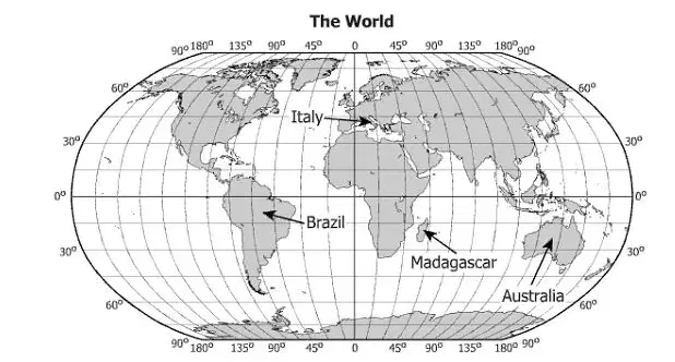
Which country contains the latitude and longitude 15°S, 45°W?
Brazil
Italy
Madagascar
Australia
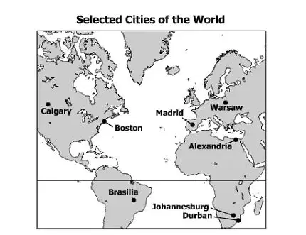
Which two cities have opposite seasons?
Boston and Madrid
Warsaw and Alexandria
Calgary and Durban
Johannesburg and Brasilia
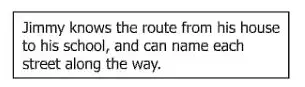
This statement is an example of —
absolute location
a primary source
a thematic map
mental mapping
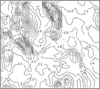
This type of map is used to show —
elevation
population
natural resources
political boundaries
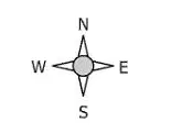
This symbol identifies which feature of a map?
Orientation
Contour
Distance
Projection
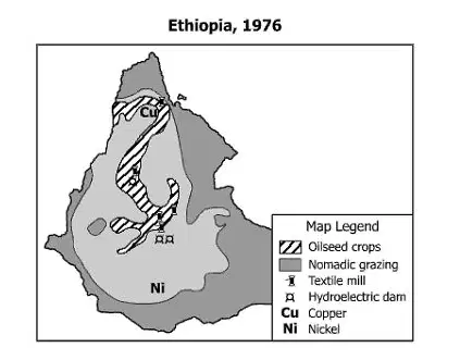
On this map, industrial activity is represented by —
shades
lines
symbols
letters
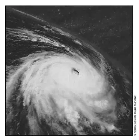
Which weather phenomenon is shown in this photograph?
Tornado
Hurricane
Blizzard
Mistral
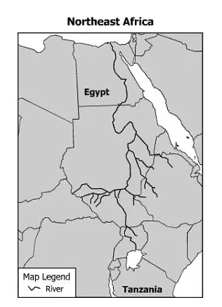
Which major river system is shown on this map?
Indus
Nile
Amazon
Danube
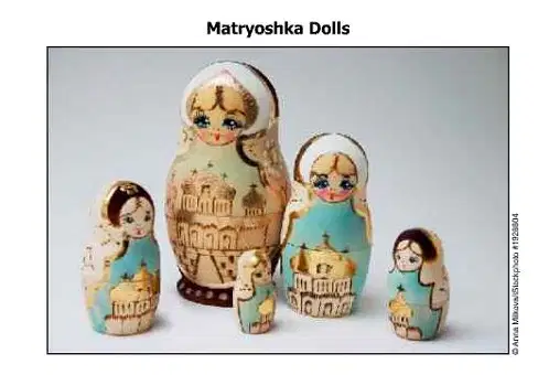
These dolls are a traditional cultural craft in —
Russia
Southeast Asia
France
Latin America
Mexico is linked more to Central and South America than to North America because of the way geographers define —
political regions
physical regions
economic regions
cultural regions
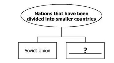
Which country best completes this diagram?
Mexico
Yugoslavia
Portugal
Chile

This river flows northward into the —
Pacific Ocean
Indian Ocean
Arctic Ocean
Atlantic Ocean
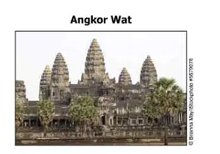
This archaeological site revealed important information about the —
traditional dwellings of Central America
architectural structures of the Middle East
ancient kingdoms of West Africa
religious history of Southeast Asia
Which name do western societies commonly use for the Arabian Gulf?
Gulf of Aden
Red Sea
Sea of Marmara
Persian Gulf
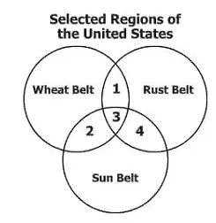
Which description is matched with the correct section of this diagram?
Section 1 represents economic regions.
Section 2 represents political regions.
Section 3 represents ethnic regions.
Section 4 represents climate regions.
The separation of Northern Ireland from the Republic of Ireland is an example of —
immigrants trying to adapt to a new government
language differences affecting growth in a region
all citizens agreeing to a political process
religion as a dividing force in a region
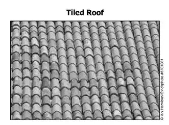
In which region is this type of roof most commonly used?
Canadian Shield
Northern Mongolia
Mediterranean
Scandinavia
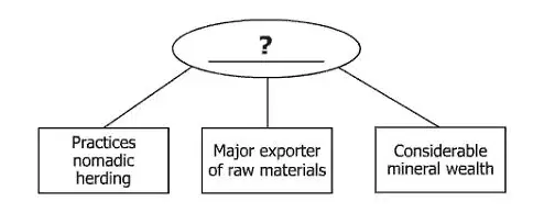
Which geographic region best completes this diagram?
North America
Sub-Saharan Africa
Western Europe
Southeast Asia
Which structure is known primarily as a national seat of government?
Eiffel Tower
Kaaba
Kremlin
Taj Mahal
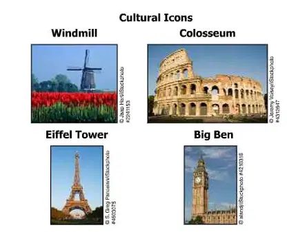
These structures are associated with the continent of —
North America
Australia
Europe
South America
Which city is a center of culture and trade located in Canada?
Inuvik
Toronto
Santiago
Chicago
Conflicts between the Hutu and Tutsi have occurred in —
Liberia
Zambia
Botswana
Rwanda
Which religion is practiced by the majority of India’s population?
Buddhism
Christianity
Hinduism
Judaism
Agricultural terracing most directly affects which landform?
Mountains
Deserts
Plains
Deltas
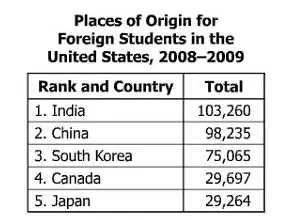
Which conclusion can be drawn from this table?
Educational opportunities in the United States are a push factor.
Most foreign educations are superior to those in the United States.
Educational opportunity pulls Asian students to the United States.
Most foreign students in the United States are European.
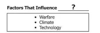
Which phrase best completes the title of this list?
Public Education
Religious Beliefs
Official Languages
Population Distribution
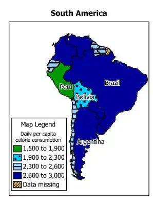
This map supports the conclusion that malnutrition is most likely to occur in which country?
Peru
Brazil
Bolivia
Argentina

The information shown in this diagram led to the expansion of —
rural areas
family farms
suburbs
canals
Which country is most likely to experience an earthquake?
England
France
Brazil
Japan
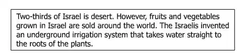
This information is an example of how technology ---
influences agricultural production
alters climate conditions
increases energy usage
affects transportation patterns
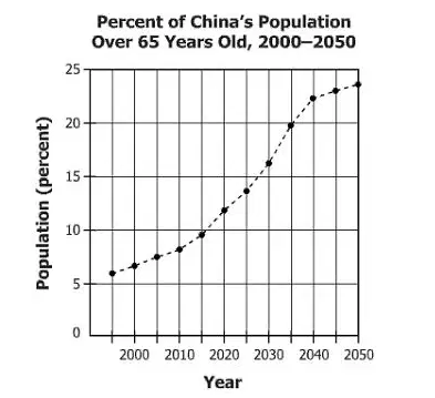
Which change to China's population between 2000 and 2050 does this graph project?
China's total population will decrease.
China's overall birthrate is expected to increase.
Less than half of China's population will be under the age of 65.
The number of Chinese people over the age of 65 will increase.
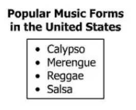
These items represent examples of ---
ethnic bias
domestic production
religious diversity
cultural diffusion
A construction company would seek the assistance of geographers in order to ---
find adequate construction materials
locate suitable construction sites
develop advanced construction methods
identify qualified construction workers
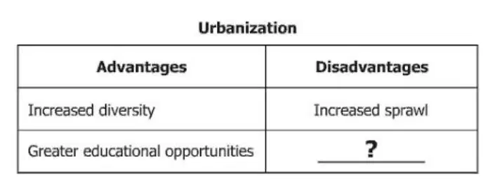
Which characteristic best replaces the question mark?
Expanded regional trade
Greater career opportunities
Increased air pollution
More cultural centers
What is an advantage to building a city at a confluence site?
Decreased regional conflicts
Improved technological innovations
Reduced risk of natural disasters
Increased access to trade routes
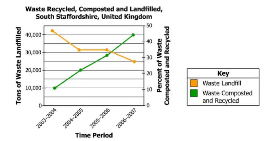
Which statement is best supported by this graph?
The amount of waste in landfills increased.
People became more involved in recycling.
The amount of waste composted decreased.
Government funding was reduced for recycling.

Which factor explains the division described in this headline?
A dispute over national independence
A conflict over natural resources
A dispute over immigration laws
A conflict over religious toleration
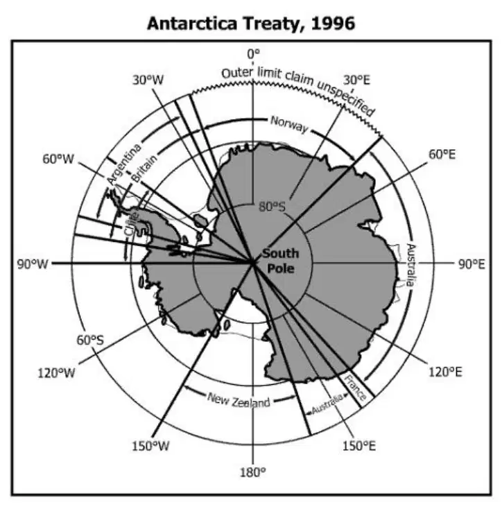
According to this map, which country does NOT have a territorial claim to Antarctica?
Britain
France
Norway
China
Which spatial division would normally regulate public bus transportation routes?
Election district
Regional district
State government
Federal government
Which factor is most responsible for increasing life expectancy in many less industrialized nations?
Declining birth rates
Availability of health insurance
Access to primary education
Improved health care programs
Which is a resource that allows nations to develop a high per-capita Gross Domestic Product (GDP)?
State-owned farms
Humanitarian aid
Skilled workforce
Governmental restrictions
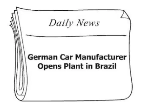
Which phrase best describes the subject of this newspaper headline?
Differences in culture
Tariff reductions on consumer goods
Unequal distribution of natural resources
Internationalization of product assembly

Which advantage best completes this diagram?
Limited foreign regulations
Reduced reliance on foreign trade
Increased global influence
Similarity of governmental systems

Which phrase best completes this diagram?
Manual labor
Limited communication
Diverse economy
Specialized production
Which is an advantage for a small, developing country in joining an economic union?
Closing of inefficient industries
Access to natural resources with restrictions
Replacing family farms with agribusinesses
Greater access to international markets
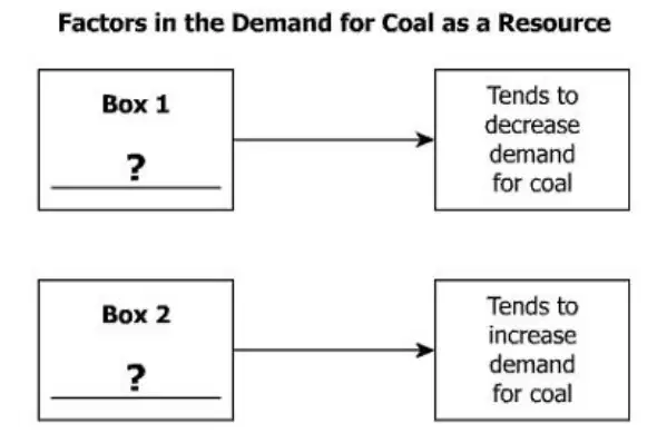
Which factor is matched with the correct box?
Environmental Concerns in Box 1
Population Growth in Box 1
Agricultural Output in Box 2
Medical Innovation in Box 2
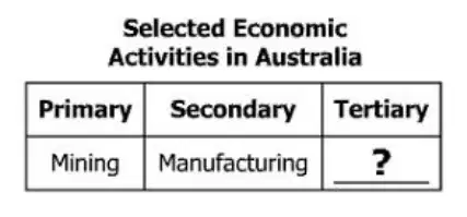
Which activity best completes this table?
Banking
Canning
Fishing
Ranching

One reason some companies choose to participate in this practice is the ---
lack of essential services
opportunity to lower production costs
need to establish labor unions
support for new technologies
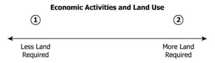
Which economic activity is correctly placed on this diagram?
Banking in 1
Ranching in 1
Shopping in 2
Manufacturing in 2
Which statement best explains why nations must trade?
All nations belong to free trade agreements.
All nations seek out new production methods.
No nation has all necessary resources.
No nation can employ all of its laborers.

