
 Worksheets
REVIEW: Bathymetry and Ocean Zones
Total questions: 255
Worksheet time: 2hrs 12mins
Which statement best defines bathymetry as presented in the section?
The study of ocean chemistry and salinity variations
The study and measurement of the depth and shape of the ocean floor
A method for predicting weather patterns over the sea
The mapping of coastal erosion rates
Bathymetric maps are most comparable to which land-based mapping approach described in the section?
Geologic stratigraphy, which layers rock formations
Topography, which maps mountains and valleys on land
Cartography, which draws political boundaries
Meteorology, which charts atmospheric pressure systems
According to the section, which instrument is specifically listed as used to measure ocean floor depth and shape?
Seismograph
Sonar
Barometer
Thermistor
Which application is directly mentioned as a reason bathymetry is important?
Forecasting monsoon rainfall
Designing offshore wind turbines
Understanding ocean currents
Measuring carbon sequestration in mangroves
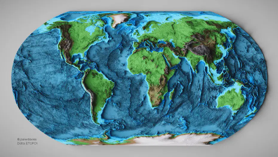
A researcher aims to locate submarine trenches and ridges across the globe. Based on the section, which resource or method would be most appropriate to start with?
Atmospheric lidar scans of sea surface winds
Bathymetric maps produced using instruments like sonar, satellites, and ships
Aerial photography of coastal regions at low tide
Soil coring from continental interiors
What does the acronym SONAR stand for in marine technology?
Sound Navigation and Ranging
Subsurface Oscillation and Reflection
Seafloor Observation and Reconnaissance
Submarine Orientation and Radar
Approximately what speed does sound travel through water, a value used by sonar systems to calculate distance?
300 meters per second
1,500 meters per second
3,000 meters per second
15,000 meters per second
A sonar device emits a pulse that strikes the seafloor and returns to the receiver. Which quantity must the system measure to compute the distance to the target?
The intensity of the returning echo
The time it takes for the echo to return
The frequency shift of the emitted pulse
The angle between transmitter and receiver
Compared with single-beam sonar, what core feature allows multibeam echo sounders to generate detailed seafloor maps in one pass?
Using lower-frequency pulses to penetrate sediment
Sending many sound beams in a fan shape to cover a broad swath
Increasing the pulse intensity to boost echo strength
Mounting sensors on the seafloor instead of the ship
A ship’s multibeam system records echo times from thousands of points. Which reasoning best explains how these data produce a 3D image of the seafloor?
Echo intensity is averaged to assign color, revealing ridges.
Return-time differences are converted to depths across the swath, which are combined spatially.
Frequency shifts indicate object composition, which defines elevation.
Beam angles are ignored so depths can be assumed uniform.
Which application is most directly enabled by the broad-swath mapping capability of multibeam echo sounders?
Measuring wind speed at the ocean surface
Nautical charting and pipeline or cable surveys
Estimating salinity from temperature profiles
Tracking satellite positions over the ocean
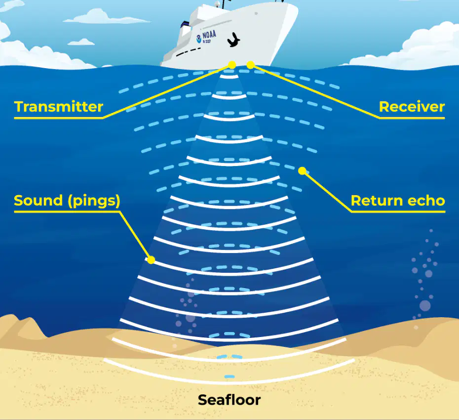
Examine the labeled diagram of a ship using sonar. Which sequence correctly traces the path of the signal involved in depth measurement?
Receiver → Return echo → Transmitter → Seafloor
Transmitter → Sound (ping) → Seafloor → Return echo → Receiver
Seafloor → Transmitter → Sound (ping) → Receiver → Return echo
Transmitter → Return echo → Seafloor → Sound (ping) → Receiver
What do satellites equipped with radar altimeters primarily measure to infer the seafloor’s shape?
Temperature variations at the sea surface
Sea surface height anomalies
Salinity gradients in the upper ocean
Color changes due to phytoplankton
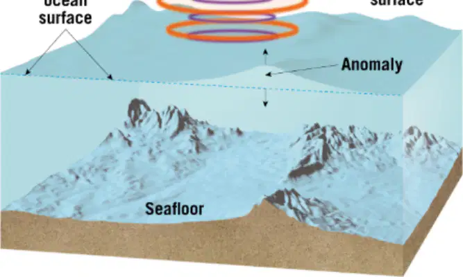
A seamount has extra mass compared to surrounding regions. Which immediate effect on the sea surface should a radar altimeter detect over a seamount?
A pronounced dip in the sea surface
No change in sea surface height
A slight upward bulge in the sea surface
A lateral shift of the sea surface without height change
Which instrument on a satellite sends radar pulses and receives their returns to determine sea surface height?
Spectrometer
Radar altimeter
Magnetometer
Infrared radiometer
If a region of ocean shows a persistent small dip relative to the theoretical ocean surface, what seafloor feature is most likely beneath it, and why?
A mid-ocean ridge, because ridges increase gravitational pull and raise the surface
A deep trench, because less mass causes weaker gravitational pull and a depression
A seamount, because extra mass draws water away lowering the surface
A flat abyssal plain, because uniform mass redistributes water downward
Which statement best explains how gravity links sea surface shape to hidden seafloor features?
Variations in gravity from underwater mass anomalies slightly redistribute water, creating measurable bulges or dips
Gravity is uniform across the ocean, so sea surface features are unrelated to seafloor topography
Only tidal forces, not gravity, determine sea surface height anomalies
Sea surface shape changes only with wind, not with subsurface mass
Compared with sonar surveys, how is satellite mapping characterized in terms of coverage and detail?
Less global coverage but more detailed than sonar
More global coverage but less detailed than sonar
Equal coverage and equal detail to sonar
Neither global nor detailed compared to sonar
Scientists want to study global plate boundaries in remote oceans. Which mapping approach is most appropriate and why?
Ship-based sonar, because it provides complete global coverage quickly
Satellite radar altimetry, because it can map the entire globe including remote regions
Diver-based visual surveys, because they directly observe the seafloor everywhere
Magnetic stripe measurements alone, because they measure sea surface height anomalies
According to current estimates, what proportion of the world’s seafloor has been mapped with high-resolution, detailed surveys?
About 10%
About 20%
About 50%
About 80%
Which statement best describes the remaining 80% of seafloor mapping referenced in the material?
It is entirely unmapped and unknown.
It is mapped at low resolution with estimated depths from satellites.
It is fully mapped with ship-based sonar but not shared publicly.
It is only mapped along mid-ocean ridges.
Why do large swaths of the deep ocean remain poorly charted? Choose the best reason given in the material.
High-resolution mapping requires expensive ships, specialized sonar systems, and significant time.
Cloud cover prevents satellite detection of ocean depths.
International treaties prohibit deep-sea mapping beyond continental shelves.
Ocean currents erase mapping data shortly after collection.
Which ocean floor division is defined as the area where the ocean meets the continents and is significant for fisheries and human activities like shipping?
Deep ocean basins
Mid-ocean ridges
Continental margins
Abyssal plains
Deep ocean basins are described in the material as which of the following?
Steep underwater cliffs adjacent to continents
Vast, flat regions of the deep ocean located beyond continental margins
Narrow trenches formed at subduction zones
Chains of seamounts atop tectonic plate boundaries
What are mid-ocean ridges, according to the text?
Underwater mountain chains that run through the world’s oceans
Flat sedimentary plains between continents
Coastal shelves used for navigation
Deep trenches formed by plate subduction
At what type of geological setting do mid-ocean ridges form, and what process occurs there?
Transform boundaries where crust slides laterally, creating rift valleys
Tectonic plate boundaries where magma rises and new ocean crust is created
Intraplate hotspots where old crust is recycled
Subduction zones where continental crust melts to form shelves
Which ocean floor division is most directly linked to understanding plate tectonics and the formation of new seafloor?
Continental margins
Deep ocean basins
Mid-ocean ridges
Abyssal plains
Which feature would most likely appear as a continuous, elevated linear structure crossing an ocean basin?
Continental shelf
Mid-ocean ridge
Abyssal plain
Continental rise
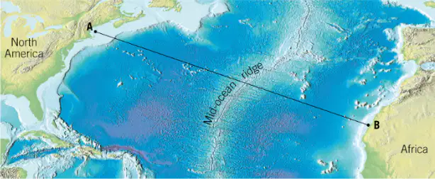
Given the cross-section diagram from North America to Africa, which sequence correctly orders major ocean floor divisions encountered when traveling from a continental margin into the open ocean?
Continental shelf → continental slope → continental rise → deep-ocean basin → mid-ocean ridge
Mid-ocean ridge → abyssal plain → continental shelf → continental slope
Deep-ocean basin → continental rise → continental slope → continental shelf
Abyssal plain → mid-ocean ridge → continental shelf → deep trench
The statement emphasizes that the ocean floor is dynamic and varied rather than a uniform, flat bottom. Which primary areas of scientific study are directly supported by exploring these regions?
Atmospheric circulation, terrestrial weather, and river hydrology
Earth’s geology, marine life, and natural resources
Astrobiology, planetary rings, and exoplanet atmospheres
Human physiology, urban planning, and agricultural engineering
A research team wants to prioritize investigations that best leverage the ocean floor’s dynamic nature and variety. Which plan most appropriately aligns with the stated purposes for studying these regions?
Map coastal tourist sites to improve recreation access and estimate hotel demand.
Measure seafloor features to infer tectonic processes, survey habitats supporting marine life, and assess resource distributions.
Track airline routes over oceans to optimize flight times and fuel efficiency.
Analyze city wastewater systems to reduce urban pollution and traffic congestion.
Which statement best defines the continental margin as used in marine geology?
The deep ocean basin beyond tectonic plate boundaries
The underwater edge of a continent marking the transition from continental crust to the deep ocean floor
A coastal dune system formed by wind-driven sand accumulation
A narrow trench created exclusively by subduction near active margins
Passive continental margins are most likely to be found along coastlines that share which tectonic characteristic?
They lie directly on active plate boundaries with frequent subduction
The ocean and continent are part of the same tectonic plate and move together quietly
They are separated by transform faults causing constant earthquakes
They sit atop mid-ocean ridges producing continuous volcanism
Which list correctly names the three main parts of a passive continental margin?
Continental shelf, continental slope, continental rise
Coastal plain, trench, abyssal ridge
Intertidal zone, reef crest, lagoon
Subduction zone, island arc, back-arc basin
According to the description, what is a typical depth of the continental shelf and why is it productive?
Greater than 2,000 meters; nutrients upwell from the mantle
Often less than 200 meters; sunlight can reach the sea floor supporting rich marine life
Exactly 650 meters; constant volcanic heating promotes life
Between 500 and 1,000 meters; hydrothermal vents dominate ecosystems
Which feature marks the true edge of the continent where continental crust thins and transitions to denser oceanic crust?
Continental shelf
Continental slope
Continental rise
Abyssal plain
What process primarily forms the continental rise at the base of the slope?
Mantle convection building basaltic plateaus
Accumulation of sediments that have slid or drifted down from the shelf and slope
Direct volcanic deposition from island arcs
Erosional scouring by tidal bores carving bedrock benches
Which statement best contrasts the continental shelf with the continental slope in terms of gradient and depth?
Both are equally steep and very deep
The shelf is gently sloping and shallow; the slope drops sharply and is much deeper
The shelf is steep and deep; the slope is flat and shallow
The shelf is flat and abyssal; the slope is elevated and terrestrial

In a passive margin setting like the U.S. East Coast bathymetry map, where would you expect the abyssal plains relative to the labeled margin features?
Landward of the continental shelf near the shoreline
Directly atop the continental slope on the steep gradient
Seaward beyond the continental rise forming the deep, flat ocean floor
Within coastal estuaries adjacent to river deltas
Oil and gas deposits and many ecosystems are commonly associated with which passive margin element and for what reason?
Abyssal plain; constant tectonic compression traps hydrocarbons
Continental slope; rapid currents prevent sediment accumulation
Continental shelf; shallow depths allow sunlight to reach the seafloor and support life
Continental rise; intense volcanism generates organic-rich shales
According to the passage, which set lists the three dynamic features associated with passive margins that shape the seafloor?
Mid-ocean ridges, transform faults, island arcs
Turbidity currents, submarine canyons, abyssal fans
Seamounts, coral reefs, hydrothermal vents
Barrier islands, tidal flats, mangrove swamps
Which statement best describes a turbidity current as defined in the text?
A slow-moving layer of warm water that forms above the continental shelf
A fast-moving underwater avalanche of sediment and water rushing down the continental slope
A stationary mud deposit that accumulates on the deep-sea floor
A surface wave that erodes beaches during storms
Which event is identified as a trigger for turbidity currents on passive margins?
Coral bleaching on the continental shelf
Earthquakes disturbing slope sediments
Formation of sea ice in polar oceans
Volcanic eruptions at mid-ocean ridges
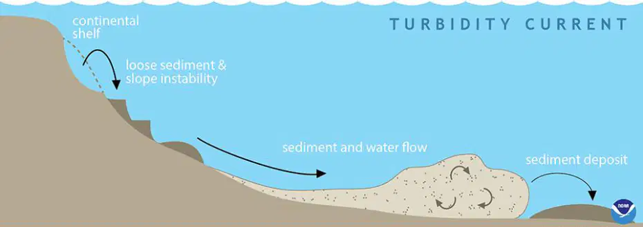
In the labeled diagram of a turbidity current, what process is shown occurring as the dense mixture moves downslope?
Chemical precipitation forming reef limestone
Seafloor erosion and transport of sediment into deeper water
Upwelling of nutrient-rich water to the surface
Deposition of loess carried by wind
What term describes the steep, V-shaped valleys cut into the continental shelf and slope by turbidity currents?
Submarine canyons
Abyssal plains
Guyots
Ocean trenches
Why are submarine canyons compared to river canyons on land in the passage?
Both form from wind erosion and show braided channels
Both are V-shaped valleys carved by flowing material
Both are circular basins formed by glacial meltwater
Both are created by volcanic lava flows
What role do submarine canyons play in sediment transport at passive margins?
They block downslope movement, trapping sediment on the shelf
They act as natural channels guiding sediments from the continent to the ocean basin
They divert sediments onto coastal beaches
They dissolve sediments before reaching deep water
When turbidity currents slow at the base of the continental slope, what feature forms from the dropped sediment?
A barrier island
An abyssal fan (deep-sea fan)
A mid-ocean ridge
A caldera
Which description of abyssal fans matches the passage?
Small dune fields limited to a few meters in length
Underwater, fan-shaped deposits that can stretch for hundreds of miles, similar to river deltas
Thin layers of ash spread by atmospheric winds
Clusters of coral forming along the continental shelf
Taken together, what do turbidity currents, submarine canyons, and abyssal fans demonstrate about Earth’s seafloor on passive margins?
Only tectonic plate motion can reshape the seafloor
Gravity and moving sediment continue to reshape the seafloor even after continents stop moving
Sea-level rise prevents any change to the seafloor
Biological activity is the sole driver of seafloor change
Which statement best defines an active continental margin?
A coastline located far from plate boundaries with broad, calm features
A coastline along or near a tectonic plate boundary where an oceanic plate is forced beneath a continental plate
A mid-ocean ridge where two oceanic plates diverge
A stable interior of a continent with thick sedimentary basins
At active margins, which process drives the formation of volcanic arcs?
Sea-floor spreading
Transform faulting
Subduction of an oceanic plate beneath a continental plate
Isostatic rebound
Which feature is characteristic of an active margin’s shelf and slope?
Wide continental shelf and gentle slope into a basin
Narrow or nearly absent continental shelf and steep continental slope dropping into a trench
Irregular shelf with numerous coral reefs and a gradual slope
Broad shelf with extensive deltas leading to a flat abyssal plain
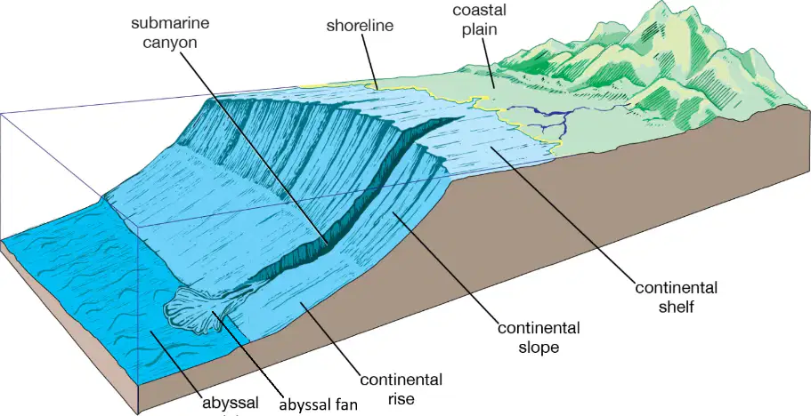
In the diagram of the continental margin, which labeled zone directly borders the shoreline on the ocean side?
Abyssal plain
Continental shelf
Continental rise
Abyssal fan
Why are continental shelves at active margins often narrow or nearly absent?
Sediments are trapped on the shelf by barrier reefs
Sediments are quickly transported into the deep ocean trench
Wave erosion removes the shelf bedrock
Glacial scouring widens the slope
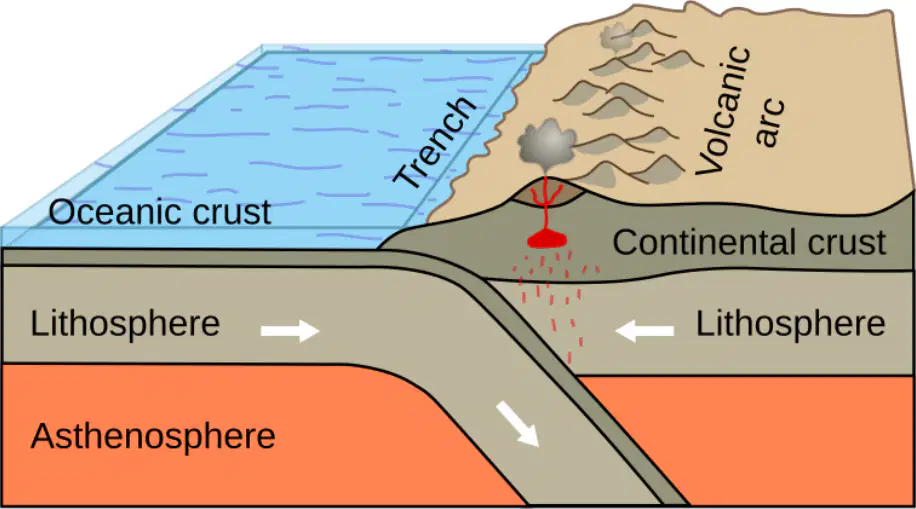
Which statement best explains how subduction leads to volcano formation at active margins?
Subducting plates create large transform faults that erupt lava directly
Melting in the mantle above the subducting slab produces magma that feeds continental volcanic arcs or volcanic island arcs
Compression thickens the crust, preventing magma generation
Hydrothermal circulation at mid-ocean ridges transfers heat to the continent
Compared with passive margins, which overall pattern describes geologic activity at active margins?
Calm settings with low tectonic activity and broad shelves
Steep, dramatic topography with frequent and sometimes strong earthquakes and volcanism
Gentle slopes and thick continental sediments
Stable cratons with little deformation
Which pairing correctly matches the feature with its description at an active margin?
Continental rise—deep, narrow valley where the oceanic plate descends
Oceanic trench—gentle ramp between slope and abyssal plain
Volcanic arc—chain of volcanoes formed as magma rises above the subducting plate
Abyssal plain—thin, rocky platform adjacent to the shoreline
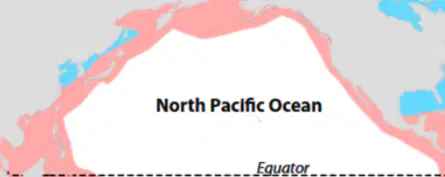
Refer to the global map showing continental margins colored red for active and blue for passive. Which ocean basin is bordered predominantly by active margins along its rim in the Northern Hemisphere?
North Atlantic Ocean
North Pacific Ocean
Arctic Ocean
Indian Ocean
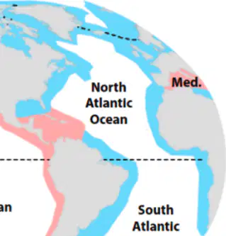
Using the global margin distribution map (red = active, blue = passive), which statement best describes the Atlantic Ocean’s continental margins?
They are mostly active margins around both North and South Atlantic.
They are mostly passive margins along both sides of the ocean.
They are active in the north and passive in the south.
They alternate active and passive with no dominant type.
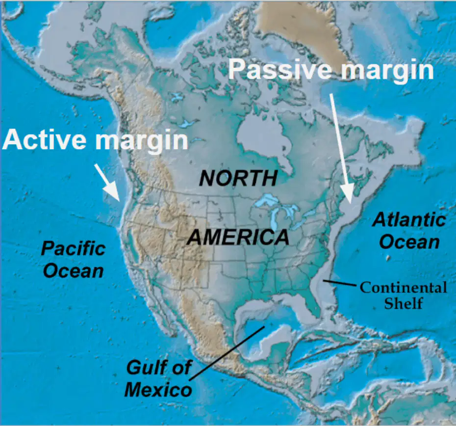
On the North America regional map, which coast is labeled as an active margin?
Atlantic coast
Gulf of Mexico coast
Pacific coast
Arctic coast
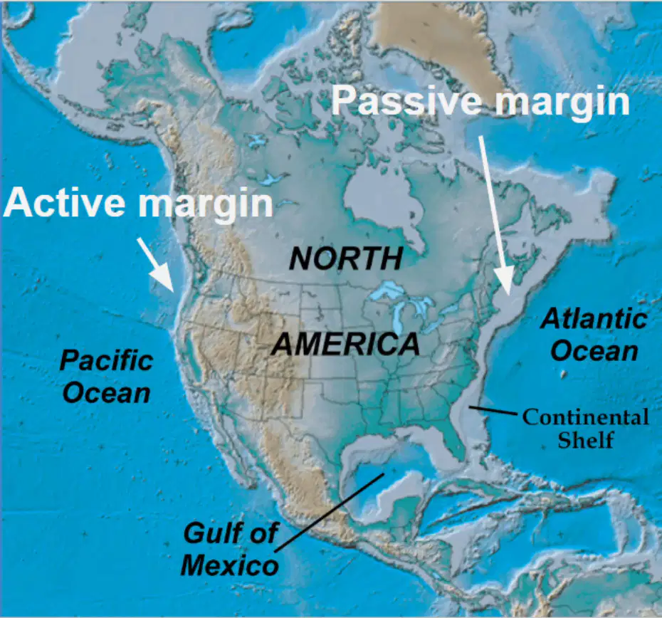
Based on the regional map of North America, which feature is explicitly marked near the Atlantic Ocean and indicates a wide, gently sloping submerged extension of the continent?
Mid-ocean ridge
Continental shelf
Oceanic trench
Volcanic arc
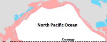
Reasoning from the global distribution map, which region is most likely to experience frequent subduction-related earthquakes and volcanoes due to active margins?
The west coasts around the Pacific Rim
The central Atlantic abyssal plains
The interiors of continental cratons
The Southern Ocean’s passive shelves
A(n) _______________ is found on the leading edge of the continent where a plate boundary is located.
Active continental margin
Passive continental margin
Deep ocean trench
Deep ocean basin
Seamount
A(n) _______________ is the transition between oceanic and continental lithosphere that is not at a plate boundary.
Active continental margin
Passive continental margin
Deep ocean trench
Deep ocean basin
Seamount

Identify letter "B"
Continental shelf
Continental slope
Continental Rise
Continental break
Turbidity current
Identify letter "A"
Continental shelf
Continental slope
Continental Rise
Continental break
Turbidity current
Identify letter "C"
Continental shelf
Continental slope
Continental Rise
Continental break
Turbidity current
Identify letter "D"
Continental shelf
Continental slope
Continental Rise
Continental break
Turbidity current

Identify #1
Turbidity current
Deep sea fan
Submarine Canyon
Deep ocean trench
Seamount
Identify #2
Turbidity current
Deep sea fan
Submarine Canyon
Deep ocean trench
Seamount
Identify #3
Turbidity current
Deep sea fan
Submarine Canyon
Deep ocean trench
Seamount

Identify #1
Turbidity current
Deep sea fan
Submarine Canyon
Deep ocean trench
Shelf break
Identify #2
Turbidity current
Deep sea fan
Submarine Canyon
Deep ocean trench
Continental break

Identify the red areas on the map:
Active continental margins
Passive continental margin
Mid-Ocean ridge
Deep ocean basin
Deep ocean trench
Identify the blue areas on the map:
Active continental margins
Passive continental margin
Mid-Ocean ridge
Deep ocean basin
Deep ocean trench
The West coast of the United States of America is a(n):
Active continental margin
Passive continental margin
Mid-ocean ridge
Rift valley
Abyssal plain
The East coast of the United States of America is a(n):
Active continental margin
Passive continental margin
Mid-ocean ridge
Rift valley
Abyssal plain
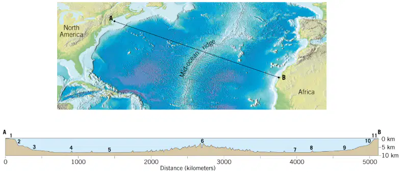
Match the regions with the locations on the diagram:
Locations 9, 10, and 11 on the diagram
Continental margin
Locations 7 and 8
Deep ocean basin
Location 6
Mid Ocean ridge
Match the regions with the locations on the diagram:
Locations 1, 2, and 3 on the diagram
Continental margin
Locations 4 and 5
Deep ocean basin
Location 6
Mid Ocean ridge
Which statement best defines the deep ocean basin?
Region between continental margin and ridge system
Shallow zone over the continental shelf margin
Narrow trench along subduction plate boundaries
Surface layer mixed by seasonal wind patterns
Which pair lists features commonly found in deep ocean basins?
Abyssal plains and seamounts
Barrier reefs and lagoons
Estuaries and deltas
Kelp forests and tide pools
Where are abyssal plains typically located relative to nearby features?
Between continental rise and mid-ocean ridge
Between shoreline cliffs and coastal dunes
Between island arcs and coral atolls
Between river deltas and submarine canyons
What is the typical temperature of abyssal plain waters?
About 2 to 3 degrees Celsius
About 12 to 15 degrees Celsius
About 25 to 28 degrees Celsius
About minus 5 to minus 2 Celsius
Which process most directly explains the flatness of abyssal plains over rough crust?
Sediment slowly burying irregular topography
Glacial scouring across deep sea floor
Hydrothermal fluids dissolving basaltic ridges
Bioturbation by large vertebrate grazers
A student argues abyssal plains cannot support life due to no sunlight. Which evidence best refutes this claim?
Presence of worms, sea cucumbers, and deep-sea fish
Detection of floating kelp forests and algae mats
Observation of coral reef symbiosis with zooxanthellae
High primary production by surface phytoplankton
Which reasoning best connects plate tectonics to deep-ocean trenches?
Trenches form where one plate is subducted beneath another
Trenches form where mantle plumes uplift oceanic crust
Trenches form where transform faults laterally offset ridges
Trenches form where sediments compact into limestone
Considering density and temperature, which factor maintains the cold stability of abyssal waters year-round?
Circulation of deep currents from polar regions
Rapid seasonal heating by tropical sunlight
Frequent mixing by shallow tidal turbulence
Continuous warming by hydrothermal vent fluids
Which description accurately contrasts trenches with abyssal plains?
Trenches are deepest narrow valleys; plains are flat broad floors
Trenches are warm shallow zones; plains are cold sunlit areas
Trenches occur on shelves; plains form near sandy beaches
Trenches host reefs; plains are dominated by mangrove forests
Which process most directly forms deep-ocean trenches at convergent plate boundaries?
Mantle upwelling at mid-ocean ridges
Lateral slipping along transform faults
Subduction of one oceanic plate beneath another
Crustal stretching during continental rifting
Which statement best describes the environmental conditions within deep-ocean trenches?
Warm, well-lit, low-pressure waters
Cold, dark, extremely high pressure
Moderate temperature with strong sunlight
Variable light with low nutrient pressure
The Mariana Trench is significant because it is
the widest ocean basin known on Earth
the deepest known location on Earth
the most active mid-ocean ridge system
the longest transform fault zone
Which organisms are most likely adapted to thrive in trench ecosystems?
Coral polyps and reef fish
Giant amphipods and sea cucumbers
Seagrasses and marine iguanas
Photosynthetic algae and krill
Why are deep-ocean trenches important to Earth’s geologic cycles and hazards?
They store atmospheric carbon permanently
They recycle ocean water through evaporation
They recycle Earth’s crust and trigger earthquakes
They prevent volcanic eruptions by cooling magma
What is the best definition of a seamount?
An underwater mountain that stays below sea level
A flat-topped island formed by wave erosion
A mid-ocean ridge that splits continents
A trench created by plates subducting downward
Most seamounts originate as which geologic feature?
Submarine volcanoes erupting through oceanic crust
Sediment mounds built by turbidity currents
Folded mountains formed by continental collision
Coral reefs growing on drowned coastlines
Which statement best explains why seamounts enhance marine life?
They generate currents that upwell deep nutrients
They block sunlight to reduce surface heating
They trap freshwater plumes from rivers
They absorb carbon directly like mangroves
Where are seamount chains most commonly concentrated?
Across the Pacific Ocean basin and hotspots
Only along Atlantic passive margins
Evenly spaced throughout all oceans
Exclusively at Arctic spreading centers
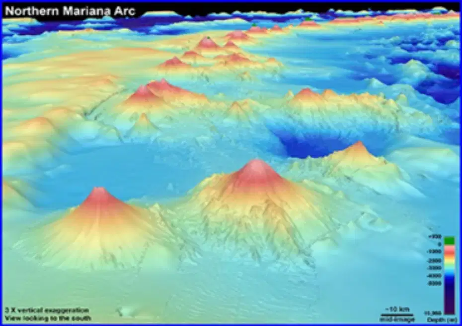
A scientist maps a line of conical peaks rising thousands of meters from the seafloor but not breaking the surface. What is the most likely interpretation?
A chain of volcanic seamounts aligned over a hotspot
A sequence of abyssal trenches at subduction zones
A shelf of continental mountains drowned by sea level
A field of coral atolls surrounding subsiding islands
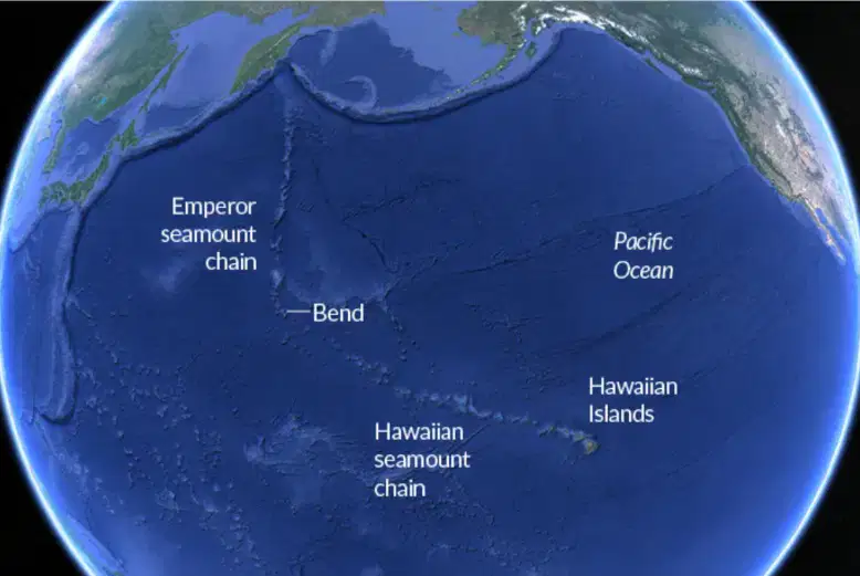
Which process most directly forms long seamount chains such as the Hawaiian-Emperor chain?
Plate motion over a stationary mantle hotspot
Rapid growth of reefs during interglacial highs
Compression at convergent continental margins
Shearing along major transform fault systems
Some seamounts eventually become islands. What change most plausibly causes this transition?
Continued volcanic build-up raises the summit above sea level
Seawater density decreases enough to expose the peak
Tectonic subduction lifts the entire ocean basin upward
Erosion hollows the summit allowing air to fill voids
Why would fisheries often target waters around seamounts?
Upwelling concentrates nutrients supporting higher biomass
Calm currents reduce fuel use for trawlers and nets
Warm plumes increase coral bleaching and predation
Deep trenches nearby protect gear from storm waves
Which feature best defines a guyot compared to other seamounts?
Steep conical summit above sea level
Flat-topped summit below sea surface
Deep central caldera venting lava
Elongated ridge parallel to coastline
What process primarily creates the flat tops of guyots over time?
Glacial scouring during ice ages
Wave erosion when islands are exposed
Sediment compaction under pressure
Chemical weathering by hydrothermal fluids
A chain of flat-topped underwater mountains is discovered near a volcanic hotspot. Which explanation best accounts for their present depth below sea level?
Subsidence as oceanic crust cools and sinks
Rapid uplift from mantle plumes last century
Tectonic compression forming fold mountains
Accumulation of coral reefs raising the seafloor
Why do scientists study guyots when reconstructing ocean floor history?
They record recent storm paths accurately
They store fossil fuels in large reservoirs
They reveal long-term changes in seafloor elevation
They control global ocean salinity levels
Which sequence best describes the development of a coral atoll around a volcanic island?
Fringing reef forms, volcano rises, lagoon drains
Volcano emerges, fringing reef grows, island subsides
Lagoon fills, barrier reef forms, volcano erupts anew
Guyot uplifts, coral dies, ring island assembles
What is a fringing reef in the context of atoll formation?
A reef that grows along a continent’s shelf edge
A coral belt attached to a volcanic island’s shores
A deep-water reef far from any landmass
A reef built on the floor of a lagoon basin
Why does a lagoon commonly appear in the center of an atoll?
Wave energy excavates a central basin over time
Coral growth blocks tides from entering the ring
The volcanic island sinks away leaving open water
Sediment mounds rise and trap rainfall inside
Which statement best explains how coral keeps pace with a sinking volcanic island?
Coral dissolves rock, halting subsidence completely
Coral grows upward, matching gradual sea-level change
Coral migrates laterally to higher seafloor terraces
Coral calcifies faster when eruptions add hot ash
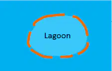
Identify the stage that directly precedes a complete atoll.
Volcanic island with fringing reef attached
Barrier reef encircling a subsiding volcano
Isolated guyot with a flat eroded summit
Collapsed caldera filled with marine sediments
Which feature most enhances coastline protection provided by atolls?
Ring-shaped reef that dissipates incoming waves
Central lagoon that stores large sediment loads
Steep volcanic slopes that reflect swell energy
Hydrothermal vents that warm coastal waters
A scientist finds a flat-topped seamount (guyot) aligned with older islands. What does this imply about regional geologic history?
Volcanic activity migrated over a stationary hotspot
A single eruption uplifted the entire oceanic plate
Coral growth ceased due to sudden global cooling
Seafloor spreading stopped along the plate boundary
Which process would most disrupt the long-term stability of an atoll ecosystem?
Gradual sea-level fall over several millennia
Moderate reef accretion keeping pace with subsidence
Frequent bleaching events reducing live coral cover
Persistent trade winds driving steady wave energy
Which feature best describes a hydrothermal vent on the seafloor?
An opening releasing hot mineral-rich fluids
A trench collecting cold nutrient-poor water
A coral mound built by calcifying animals
A sand chimney formed by wave currents
Why does water near deep-sea vents not boil despite being extremely hot?
Intense pressure raises the boiling point
Salts completely remove dissolved gases
Rapid currents cool the surrounding water
Darkness prevents phase changes from occurring
Black smokers are most directly associated with which process at mid-ocean ridges?
Magma heating seawater in crustal cracks
Glacial meltwater flowing into abyssal plains
Photosynthetic algae colonizing rocky outcrops
Tidal erosion sculpting submarine canyons
Which statement best defines extremophiles in the vent environment?
Organisms thriving under extreme conditions
Fish migrating across temperate waters
Plants adapting to seasonal daylight changes
Predators specializing on reef herbivores
What role do chemosynthetic bacteria play in vent ecosystems?
Primary producers forming the food web base
Secondary consumers grazing on tube worms
Decomposers recycling calcium carbonate shells
Parasites reducing clam reproductive output
Which chemicals are most relevant to chemosynthesis near vents?
Hydrogen sulfide and carbon dioxide
Glucose and atmospheric nitrogen
Methane and chlorophyll pigments
Sodium chloride and silica sand
How do chemosynthetic bacteria obtain energy in the absence of sunlight?
By oxidizing vent-derived inorganic compounds
By fermenting detritus from surface waters
By absorbing geothermal infrared photons
By storing energy in calcium carbonate
A researcher measures a sudden drop in vent fluid hydrogen sulfide. Which immediate ecological effect is most plausible?
Reduced bacterial primary productivity at vents
Increased photosynthesis by deep-sea algae
Rapid growth of filter-feeding corals nearby
Stabilized temperatures within vent chimneys
Which prediction best explains why tube worms cluster around active chimneys?
Symbiotic bacteria access chemicals efficiently
Larval worms require strong tidal currents
Adult worms feed directly on boiling water
Worm hemoglobin binds atmospheric oxygen
Which of the following are the three (3) major divisions of the ocean:
Deep ocean basin
Continental margin
Mid ocean ridge
Deep ocean trench
Seamounts
The portion of the seafloor that lies between the continental margin and the oceanic ridge system. It includes the abyssal plain, trenches, seamounts and guyots.
Deep ocean basin
Deep ocean trench
Mid ocean ridge
Active continental margin
Passive continental margin
The relatively level deep seafloor. It is a cold and dark place that lies between 3,000 and 6,000 meters below the sea surface.
Deep ocean basin
Abyssal plain
Mid ocean ridge
Active continental margin
Passive continental margin

Identify #1 and #11
Continental shelf
Continental slope
Continental rise
Seamount
Rift Valley
Identify #2 and #10
Continental shelf
Continental slope
Continental rise
Seamount
Rift Valley
Identify #3 and #9
Continental shelf
Continental slope
Continental rise
Seamount
Rift Valley
Identify #4 and #8
Continental shelf
Continental slope
Continental rise
Seamount
Rift Valley
Identify #6
Continental shelf
Continental slope
Continental rise
Seamount
Rift Valley
Identify #5 and #7
Continental shelf
Abyssal plain
Continental rise
Seamount
Rift Valley
Which are part of the deep ocean basin (CHOOSE ALL THAT APPLY):
Trenches
Seamounts
Guyots
Abyssal plains
Continental shelf
Which region contains the deepest part of the ocean:
Deep ocean basin
Continental margin
Mid ocean ridge

Item #1
Abyssal plain
Item #2
Seamount
Item #3
Trench
Hot springs that are produced by underwater volcanoes at spreading ridges and convergent plate boundaries. They provide chemicals for chemosynthetic organisms.
Hydrothermal vents
Turbidity currents
Submarine canyons
Seamounts
Guyots
Hydrothermal vents are surrounded by organisms that thrive in extreme environments. These organisms are called:
(a)
Seawater around hydrothermal vents does not boil due to:
the water is not hot enough to boil
the ocean is cold and disperses the heat quickly
the intense pressure keeps the molecules tightly packed together
the lack of sunlight makes the water molecules move closer together
there is too much salt in the water to boil (the salt increases the boiling point)
Chemotrophs get their energy from:
the sun
chemicals
other living organisms
electricity
a ring-shaped reef that forms around a subsiding island. The reef surrounds a body of water called a lagoon.
Coral atoll
Rift valley
Seafloor spreading
Submarine canyon
Turbidity current

The image depicts the formation of:
A coral atoll
A submarine canyon
A rift valley
A cinder cone
Which region contains the challenger deep:
Deep ocean basin
Continental margin
Mid ocean ridge
Which region contains the deepest part of the ocean:
Deep ocean basin
Continental margin
Mid ocean ridge
Which are part of the deep ocean basin (CHOOSE ALL THAT APPLY):
Trenches
Seamounts
Guyots
Abyssal plains
Continental shelves
Which statement best defines plankton in aquatic ecosystems?
Drifting organisms carried by currents
Strong swimmers that chase prey
Bottom dwellers attached to rocks
Free-living microbes on land
Which pair correctly matches plankton type with its primary trait?
Phytoplankton—photosynthetic producers
Zooplankton—oxygen producers
Phytoplankton—animal-like feeders
Zooplankton—rooted to the seafloor
Identify the main difference between plankton and nekton.
Movement by drifting vs active swimming
Size small vs very large only
Marine habitat vs freshwater only
Microscopic vs vertebrate only
Which group includes organisms that live on, in, or near the bottom?
Benthos in benthic habitats
Nekton in pelagic zones
Plankton in deep currents
Phytoplankton in coral reefs
Which example is correctly classified as nekton?
Tuna and salmon, active swimmers
Diatoms and dinoflagellates
Copepods and krill larvae
Sea stars and clams
Phytoplankton primarily contribute to aquatic ecosystems by
Producing oxygen via photosynthesis
Scavenging carrion and waste
Predating on small fish larvae
Fixing nitrogen in sediments
Zooplankton are best described as
Animal-like consumers of plankton
Plant-like oxygen producers
Sessile bottom filter feeders
Free-swimming top predators
Which statement explains why plankton are foundational to food chains?
They form the base as primary producers
They are the largest marine predators
They recycle nutrients in sediments
They attach to rocky substrates
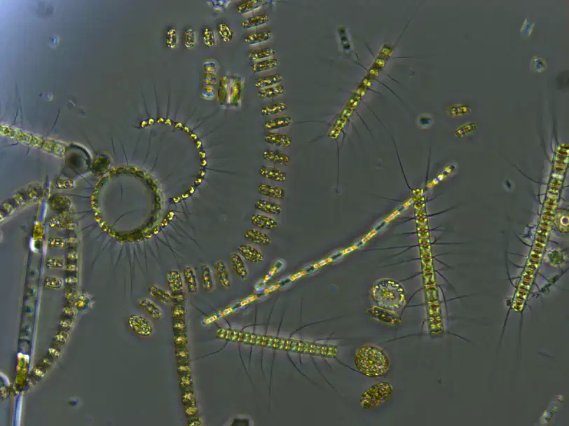
A student observes tiny golden chains of cells under a microscope (see image). What is the most likely classification?
Phytoplankton performing photosynthesis
Zooplankton larval crustaceans
Nekton juvenile fish schools
Benthos sand-burrowing worms
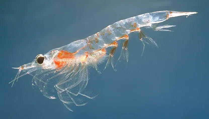
Krill pictured are part of which category and why?
Zooplankton that consume plankton
Phytoplankton that photosynthesize
Nekton that actively chase prey
Benthos that anchor to substrates
Choose the best reasoning for why nekton can move independently of currents.
They have muscles and fins for propulsion
They possess gas vacuoles for buoyancy
They anchor with tube feet to rocks
They rely on tidal energy to drift
Which scenario correctly traces energy flow involving plankton?
Phytoplankton → zooplankton → fish
Zooplankton → phytoplankton → whales
Benthos → nekton → phytoplankton
Nekton → benthos → zooplankton
If a warming event reduces phytoplankton abundance, which outcome is most plausible?
Zooplankton and fish populations decline
Nekton speed increases significantly
Benthos immediately migrate offshore
Zooplankton begin photosynthesizing
Compare ecosystem roles—what distinguishes benthos from plankton and nekton in nutrient cycling?
Benthos break down organic matter
Plankton regulate tidal currents
Nekton fix atmospheric nitrogen
Plankton anchor sediments tightly
Which statement best defines the intertidal zone along a shoreline?
Area always submerged by ocean water
Region between highest and lowest tide marks
Zone permanently exposed to air and sunlight
Deep-water region above the continental slope
Which challenge most consistently affects organisms living in the intertidal zone?
Stable temperatures year-round
Constant freshwater availability
Fluctuations in water, waves, and sunlight
Unlimited shelter from predators
Mussels, abalone, and hermit crabs in the middle tide zone must
Avoid all wave action entirely
Withstand waves and air exposure
Remain submerged at all times
Live only on sandy bottoms
Sea stars, sponges, and sea urchins are commonly found in which intertidal sub-area?
Spray Zone
High Tide Zone
Middle Tide Zone
Low Tide Zone
Which factor makes the low tide zone the most stable part of the intertidal area?
Constant exposure to wind and sun
Frequent drying between wave events
Persistent submersion with ample water
Continuous shifts in salinity levels
Which reasoning best explains why intertidal organisms often have strong attachment structures?
To migrate long distances daily
To resist dislodgement by waves
To increase buoyant lift for swimming
To avoid predation by deep-sea fish
Which description best defines the neritic zone in terms of location and depth?
Shallow waters over continental shelf to ~200 meters
Deep open ocean beyond shelf to ~4,000 meters
Coastal intertidal area exposed at low tide only
Abyssal plain sediments below ~3,000 meters
Why is the neritic zone among the most productive ocean regions?
High sunlight and nutrient availability
Cold temperatures and low oxygen
Minimal phytoplankton and weak currents
Extreme pressure limiting predation
Which group forms the base of the food web in the neritic zone?
Phytoplankton
Sea turtles
Crustaceans
Dolphins
Which set lists organisms commonly found in the neritic zone?
Fish, corals, seaweeds, crustaceans
Giant tube worms, hagfish, amphipods
Ice algae, penguins, krill, seals
Lanternfish, jellyfish, vampire squid
A government plans sustainable fisheries. Which ocean region should be prioritized to maximize economic impact while protecting biodiversity?
Neritic zone on the continental shelf
Mid-ocean gyres far from coasts
Bathypelagic zone below 1,000 meters
Hadal trenches within subduction zones
Which statement best defines a coral reef?
A rigid structure built by volcanic lava flows
A large formation of calcium carbonate from polyps
A rocky shelf carved by ocean currents over time
A plant-based underwater forest of seaweeds
What material do most coral polyps secrete to build protective skeletons?
Silicon dioxide forming glassy spicules
Calcium carbonate forming hard skeletons
Magnesium sulfate forming soft deposits
Sodium chloride forming crystalline shells
Where do corals primarily thrive due to light availability?
Cold, deep ocean trenches with minimal light
Warm, shallow waters where sunlight penetrates
Temperate mid-depth zones below the photic layer
Brackish estuaries with fluctuating turbidity
Zooxanthellae benefit corals by providing which service?
Nitrogen fixation through chemosynthesis
Food via photosynthesis within coral tissues
Mechanical defense with stinging nematocysts
Active transport of calcium ions for skeletons
Why are coral reefs often called the “rainforests of the sea”?
They cover continents with dense vegetation
They host exceptional biodiversity and many species
They produce cloud-forming aerosols at high rates
They grow exclusively in areas with monsoon rains
Which description correctly characterizes coral polyps?
Single-celled algae lacking mouths and tentacles
Soft-bodied animals with mouths and tentacles
Hard-shelled crustaceans with jointed appendages
Plant-like organisms performing external photosynthesis
Identify the approximate length of the Great Barrier Reef along Australia.
About 500 kilometers spanning coastal bays
Around 1,400 miles or 2,300 kilometers
Nearly 10,000 kilometers across the Pacific
Exactly 900 miles from Perth to Sydney
Which statement about the Great Barrier Reef’s composition is accurate?
It is a single continuous island of coral rock
It includes over 2,900 reefs and about 900 islands
It consists of three reefs separated by deep canyons
It is purely seagrass beds without coral formations
Which misconception is corrected by understanding coral biology?
Corals are colorful plants rooted in sand
Corals are tiny animals called polyps forming reefs
Corals are ancient minerals deposited by rivers
Corals are floating jellyfish colonies in bays
Which feature of the Great Barrier Reef is observable even from space?
Its underwater caves filled with bioluminescence
Its sheer size and extent along the coastline
Its nightly spawning events of individual polyps
Its migrating turtle populations during nesting
Which region is recognized as the global center of marine biodiversity?
Arctic Circle surrounding the polar seas
Mediterranean Basin near southern Europe
Coral Triangle in the western Pacific Ocean
Mid-Atlantic Ridge spanning the Atlantic
Which countries are part of the Coral Triangle’s tropical waters?
Australia, New Zealand, Fiji, Vanuatu
Indonesia, Malaysia, Philippines, and others
Japan, South Korea, Taiwan, and China
India, Sri Lanka, Maldives, and Bangladesh
A decline in zooxanthellae populations inside corals would most directly reduce which process?
Photosynthetic food production for corals
Salt regulation by coral polyps’ kidneys
Predation rates by reef fish on corals
Sediment deposition on coral skeletons
Zooxanthellae primarily provide corals with which essential benefit?
Food and pigmentation
Calcium carbonate ions
Protection from predators
Higher water circulation
Ocean acidification begins with excess atmospheric CO2 doing what?
Dissolving into seawater
Condensing over reefs
Forming dust aerosols
Binding to fish scales
Which material composes the structural skeletons of corals?
Calcium carbonate
Silicon dioxide
Magnesium silicate
Sodium chloride
Spawning aggregations are vulnerable to overfishing primarily because
Many adults gather predictably, making capture easy
Larvae resist nets and escape most gear
Fish avoid reefs during spawning seasons
Aggregations increase predator defense mechanisms
Removing too many large reef fish most directly leads to
Fewer larvae to replenish populations
Immediate increase in coral growth rates
Higher carbonate ion concentrations
More herbivores that control algae
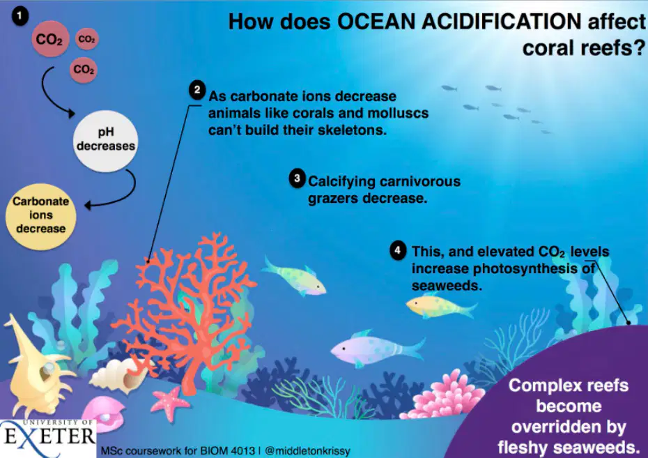
Ocean acidification decreases carbonate ions. What consequence does this have for corals and mollusks?
They struggle to build their skeletons
They photosynthesize more efficiently
They disperse farther during spawning
They switch to silicon-based structures
A coastal community wants to reduce overfishing impacts on nearby reefs. Which combined actions are most effective?
Choose sustainable seafood and follow local regulations
Increase catch limits and target spawning aggregations
Use non-selective nets and harvest only large fish
Install more traps near reefs to remove predators
Marine debris such as lost nets and lines harms reefs mainly by
Physically damaging corals and taking long to recover
Reducing herbivore digestion and carbonate release
Altering pH to increase carbonate ions
Providing shelter that restores fish nurseries
Which statement best defines the oceanic zone relative to the continental shelf?
Open ocean beyond the continental shelf edge
Shallow water atop the continental shelf
Coastal waters within bays and estuaries
Deep trenches directly under the shelf
What primarily distinguishes the neritic zone from the oceanic zone?
Neritic is shallow over the continental shelf
Neritic has no marine life at all
Oceanic contains only freshwater inputs
Oceanic lies closer to beaches and tides
How deep does sunlight typically penetrate to form the photic (epipelagic) zone?
About 200 meters, roughly 650 feet
About 20 meters, roughly 65 feet
About 2,000 meters, roughly 6,500 feet
About 2 meters, roughly 6.5 feet
Why is the photic zone the site of most oceanic photosynthesis?
Sufficient sunlight reaches the upper waters
Nutrients are absent from deep waters
Currents stop mixing near the seabed
Salinity drops to nearly freshwater
Which organisms form the base of the ocean food chain in the photic zone?
Phytoplankton, tiny plant-like organisms
Zooplankton, small drifting animals
Cephalopods, active midwater hunters
Benthic invertebrates on the seafloor

Which ecological role of the oceanic zone has global significance?
Supports food chains and helps produce oxygen
Blocks heat exchange with the atmosphere
Prevents carbon from dissolving in seawater
Eliminates predators from coastal systems
What challenge increases for organisms living below the photic zone?
Darkness, high pressure, cold temperatures
Excessive light and overheating
Freshwater intrusion and low salinity
Abundant photosynthesis and plant growth
Which combination best explains why many animals inhabit the photic zone?
Availability of food and light
Absence of predators and waves
Presence of caves and hard substrates
High pressure and strong currents
Which marine group is commonly found in the photic zone due to sunlight dependence?
Corals with symbiotic algae
Abyssal tube worms
Deep-sea anglerfish
Subterranean amphipods
Select the best description of phytoplankton.
Microscopic plant-like photosynthesizers
Microscopic animal-like filter feeders
Large predatory fish species
Seafloor-dwelling crustaceans
Which statement links the photic zone to climate regulation?
Photosynthesis there contributes oxygen production
Turbidity there blocks atmospheric circulation
Ice formation there drives monsoon cycles
Salinity there controls wind patterns globally
If the depth of sunlight penetration decreased to 100 meters, what immediate effect would most likely occur?
Reduced phytoplankton productivity
Increased deep-sea photosynthesis
Expanded coral reef growth offshore
Higher oxygen production in darkness
A food chain beginning with phytoplankton in the photic zone most directly supports which consumers next?
Zooplankton that graze on phytoplankton
Benthic detritivores feeding on sediments
Top predators bypassing lower trophic levels
Chemosynthetic bacteria near vents
Where would sharks and sea turtles most likely be observed according to this material?
Photic zone within the open ocean
Aphotic zone below sunlight reach
Freshwater lakes and rivers
Subtidal caves on the shelf
Which statement best defines the aphotic zone in the ocean?
Region with intense sunlight supporting photosynthesis
Dark region where sunlight does not penetrate
Shallow coastal area with tidal mixing
Layer with constant warm temperatures and low pressure
At approximately what minimum depth does the aphotic zone begin in most oceans?
Around 50 meters below sea level
Around 200 meters below sea level
Around 20 meters near reefs
Around 2,000 meters in trenches
Why can’t plants like algae grow in the aphotic zone?
Nutrients are too abundant for growth
Temperatures are too warm for enzymes
Photosynthesis cannot occur without sunlight
Water salinity is too low for chloroplasts
Which adaptation is most characteristic of organisms in the twilight (mesopelagic) zone?
Large eyes to capture faint light
Thick shells to resist wave action
Bright coloration for camouflage
Air-filled lungs for surface breathing
Bioluminescence in deep-sea organisms primarily functions to:
Increase oxygen production for plants
Communicate, attract prey, or evade predators
Warm the surrounding water for metabolism
Generate electricity for movement
Which zone is typically between 200 and 1,000 meters deep and has very dim light?
Photic (epipelagic) zone
Twilight (mesopelagic) zone
Midnight (bathypelagic) zone
Abyssal (abyssopelagic) zone
Identify a pressure-related challenge for organisms in the midnight (bathypelagic) zone.
Low pressure causing gas expansion
Moderate pressure supporting buoyancy
Extremely high pressure compressing tissues
Variable pressure from tidal cycles
Which statement accurately contrasts the twilight and midnight zones?
Twilight has faint light; midnight lacks sunlight
Twilight is warmer; midnight has warm currents
Twilight supports photosynthesis; midnight does too
Twilight is shallower than the photic; midnight is shallower
Many mesopelagic animals migrate vertically each day. What is the typical pattern?
Up by day, down at night to avoid predators
Down by day, up at night to feed near surface
Stay at depth continuously to conserve energy
Random movement unrelated to light levels
Which example organism is commonly associated with bioluminescence in deep waters?
Sea urchins in tide pools
Jellyfish and some squids
Coral polyps on reefs
Seagrasses in lagoons
What ecological role does the aphotic zone play despite being dark and remote?
It supports diverse life with sinking nutrients
It eliminates carbon from surface waters
It blocks ocean circulation and climate regulation
It serves only as a geological sediment trap
Which factor most directly limits vision in the midnight zone?
High turbidity from sediments
Complete absence of sunlight
Excess chlorophyll absorption
Strong surface glare at noon
A researcher observes fish with reduced pigmentation and pressure-resistant enzymes. Which zone are these traits most suited for?
Photic (epipelagic) zone near surface
Twilight (mesopelagic) zone only
Midnight (bathypelagic) deep waters
Intertidal zone along shores
Which statement about photosynthesis across ocean zones is accurate?
Occurs widely in twilight and midnight zones
Occurs only in the aphotic zone
Occurs primarily in the photic zone
Occurs equally at all depths
Consider predator-prey interactions in dim light. Which adaptation best improves prey detection in the twilight zone?
Large eyes with sensitive retinas
Bright pigments reflecting sunlight
Thick scales resisting abrasion
Surface lungs for rapid oxygen intake
Which depth range best corresponds to the abyssal zone in the open ocean?
200–1,000 meters below surface
1,000–4,000 meters below surface
4,000–6,000 meters below surface
Below 6,000 meters depth
Which statement accurately distinguishes the hadal zone from the abyssal zone?
Hadal has warmer temperatures than abyssal
Hadal lies deeper than abyssal trenches
Abyssal has lower pressure than hadal
Abyssal contains more hydrothermal vents
What primary light condition characterizes both abyssal and hadal zones?
Dim twilight from scattered photons
Periodic sunlight during clear days
Complete darkness absent solar light
Variable daylight filtered through ice
Which adaptation helps abyssal fishes withstand extreme hydrostatic pressure?
Rigid calcified skeletons throughout
Gas-filled swim bladders enlarged
Flexible bodies with reduced gas spaces
Thick scales trapping compressible air
Marine snow primarily consists of which materials?
Minerals from mid-ocean ridges
Detritus of organic particles
Live phytoplankton colonies
Pelagic fish eggs exclusively
Hydrothermal vents in deep oceans are significant because they provide what to local ecosystems?
Sunlight for photosynthesis
Heat and chemical energy
Freshwater and oxygen plumes
Low-pressure safe habitats
Which food-web relationship is typical in abyssal communities relying on marine snow?
Primary producers dominate biomass
Chemosynthetic bacteria feed predators
Detritivores process sinking organics
Zooplankton graze surface algae
Why are photosynthetic plants absent in abyssal and hadal zones?
Nutrients are too abundant there
Salinity exceeds tolerance levels
No sunlight reaches those depths
Temperatures exceed enzyme limits
A fish evolved bioluminescent lures and expandable jaws. Which ecological strategy does this reflect?
Filter feeding on plankton
Ambush predation in darkness
Mutualism with vent tube worms
Herbivory on deep algae
Compared with the bathypelagic zone, what is a defining feature of the hadal zone?
Located along abyssal plains
Occupies oceanic trenches
Receives faint blue sunlight
Has warmer bottom waters
Which factor most limits metabolic rates of deep-sea animals in abyssal habitats?
High oxygen supersaturation
Chronic food scarcity
Low hydrostatic pressure
Frequent temperature spikes
If marine snow input declines significantly, which population is first directly affected?
Surface phytoplankton communities
Abyssal detritivores and scavengers
Trench-dwelling apex predators
Hydrothermal vent archaea
A researcher measures 650 atmospheres of pressure. Which zone is most likely being sampled?
Epipelagic photic region
Mesopelagic twilight waters
Abyssopelagic plains habitat
Hadopelagic trench environment
What process supplies energy to deep ecosystems around hydrothermal vents without sunlight?
Aerobic photosynthesis
Anoxygenic phototrophy
Chemosynthesis using reduced chemicals
Fermentation of marine snow
Which depth range best describes the abyssal zone in the ocean?
1,000 to 3,000 meters deep
4,000 to 6,000 meters deep
6,000 to 11,000 meters deep
200 to 800 meters deep
What is a defining environmental condition common to both abyssal and hadal zones?
Strong sunlight penetration
Warm temperatures year-round
Complete darkness and cold
Low pressure and mild currents
The hadal zone is primarily located in which seafloor feature?
Mid-ocean ridges
Continental shelves
Ocean trenches
Seamount plateaus
Which statement best explains why deep-sea animals often have slow metabolisms?
To conserve energy when food is scarce
To avoid predation by larger fish
To maintain buoyancy in warm water
To increase growth rates under sunlight
Marine snow is most accurately described as what?
Ice crystals formed in deep currents
Sediment eroded from continental slopes
A drift of dead organic material
Gas bubbles from hydrothermal vents
Which adaptation helps organisms withstand extreme pressure in the hadal zone?
Rigid, calcified skeletons
Soft, flexible body structures
Large gas-filled swim bladders
Thick layers of insulating fat
Which group includes typical abyssal zone residents?
Reef corals and parrotfish
Giant tube worms and basket stars
Kelp and sea otters
Polar cod and penguins
Food webs in the hadal zone often rely on which source?
Photosynthetic algae blooms
Organic material sinking downward
Plankton carried by trade winds
Sand dollars grazing on seagrass
Why would most human-made objects be crushed in the hadal zone?
High salinity dissolves metals
Immense pressure exceeds design limits
Acidic waters corrode quickly
Magnetic fields distort structures
Which trait is associated with deep-sea bioluminescence in abyssal organisms?
Light production for communication
Heat generation for metabolism
Sound emission to stun prey
Electroreception to sense currents
Compare energy pathways: Which statement best contrasts abyssal and hadal food sources?
Both rely mainly on coastal upwelling
Abyssal relies on marine snow; hadal adds vent microbes
Both depend on sunlit phytoplankton
Abyssal depends on seagrass; hadal on kelp detritus
A student proposes using rigid metal frames to protect hadal organisms from pressure. What is the main flaw in this idea?
Rigid frames trap heat in cold water
Rigid structures fail under crushing pressure
Metal frames block needed sunlight
Rigid frames stop nutrient diffusion
Which statement best defines the benthic zone in aquatic systems?
The sunlit surface layer of open water
The bottom layer of a body of water
The midwater region with weak light
The shoreline area between tides
Which location would NOT be part of the benthic zone?
Ocean floor sediments
Deep lake bed mud
Riverbed gravel bars
Open-water midwater column
Which organisms are most representative of benthic life?
Crabs, clams, sea stars
Tuna, dolphins, sharks
Jellyfish, squid, eels
Plankton, algae, kelp
What does the term bottom feeder describe in this context?
Hunter of fast-swimming prey
Consumer of sinking organic matter
Filterer of dissolved minerals
Producer using sunlight for energy
Which behavior most distinguishes many benthic organisms from pelagic species?
Living in or on the substrate
Migrating long ocean distances
Forming schooling aggregations
Breathing air at the surface
Which role of the benthic zone most directly contributes to ecosystem nutrient cycling?
Storing heat in surface waters
Recycling organic detritus
Producing atmospheric oxygen
Blocking oceanic currents
A researcher maps zones from photic to hadal. Where is the benthic zone in this profile?
Along the seafloor at all depths
Only within the photic region
Only in abyssal trenches
Just at the intertidal beach
Which statement compares sessile and mobile benthic organisms correctly?
Sessile remain attached; mobile move
Sessile migrate seasonally; mobile don’t
Sessile breathe air; mobile filter water
Sessile photosynthesize; mobile hunt
Why is the benthic zone vital for marine food webs?
It supplies fast surface currents
It supports detritus-based feeding
It eliminates all predators
It prevents vertical mixing
Which management action best protects benthic ecosystem health in deep areas?
Increase bottom trawling intensity
Limit seafloor habitat disturbance
Add artificial surface lighting
Encourage open-water fish farms

