
Font size
 Worksheets
Unit Check in
Total questions: 46
Worksheet time: 45mins

A large body of water surrounded by land.
Ocean
Lake
River
Plain

The largest landmasses (there are seven)
Convience
Consequences
Continents
Constantinople

A large natural stream of water that empties into an ocean, sea or lake.
River
Lake
Sea
Ocean

A large, elevated area of land (sometimes flat)
Plateau
River
Island
Peninsula

A piece of land totally surrounded by water.
Island
Peninsula
Plain
Cape

A natural elevation of the earth that is higher than a hill
hill
mountain
Plain
Peninsula

A piece of land surrounded by water on three sides.
Island
Plateau
Plain
Peninsula

A huge body of salt water. Five of these cover about 75% of the earth.
lakes
seas
oceans
ponds

A large flat land area with very few trees.
Plains
Peninsula
Mesa
Plateau

A chain of mountains
mountain
mountain range
plateau
mountain patch

An inland body of water of considerable size. Usually freshwater, but can be salt water.
sea
lake
pond
ocean

What is a canyon?
A flat, low lying land built up from soil carried downstream by a river and deposited at its mouth
A step, a high wall of rock, earth, or ice
A deep and narrow valley with steep walls
The part of large body of water that extends into a shoreline

What is a Desert?
A step, high wall of rock, earth, or ice
A region of vegetation, either cold or hot, that receives less than ten inches of precipitation per year
a flat, low lying land built up from soil carried downstream by a river
A sheltered place along a shoreline where ships can anchor safely

What is a Glacier?
a sheltered place along a shoreline where ships can anchor safely
Part of a body of water that extends into a shoreline generally larger and more deeply indented than a bay
a narrow stretch of land connecting two larger land areas
A large, thick body of slowly moving ice

What is a Plateau?
A mountain created as liquid rock and ash erupt from inside the earth
An area of flat or rolling land at a high elevation, about 300-3,000 feet
A region of vegetation at high latitudes, high elevations, and characterized by cold temperatures and sparse vegetation
An area of low land between hills or mountains

What is a valley?
Land with steep sides that rises sharply (1000 feet or more) from surrounding land
a body of land jutting into a lake or ocean, surrounded on three sides by water
An area of level land, usually at low elevation and often covered by grasses
An area of low land between hills or mountains

Name this physical feature.
Plateau
Butte
Mesa
Mountain

Name this physical feature.
Plateau
Butte
Mesa
Mountain

Name this physical feature.
Plateau
Hill
Oasis
Desert

Name this physical feature.
Mountain
Volcano
Mesa
Desert

Name this physical feature. (Looking at the flat land in the middle)
Mountain
Plains
Valley
River

Name this physical feature.
Mountain
Plains
Valley
River

Name this physical feature.
Mountain
Plains
Valley
River

Name this physical feature.
Mountain
Plains
Valley
Canyon

Name this physical feature.
River
Plains
Valley
Glacier

Name this physical feature. (Looking at the land feature here)
Gulf
Delta
Island
Peninsula

Name this physical feature.
Desert
Glacier
Oasis
Mountain
This climate zone is located on the equator and is the hottest climate zone.
Tropic
Temperate
Polar
The climate zone has mild temperatures and a half year long growing season.
Tropic
Temperate
Polar
This climate zone is the coldest.
Tropic
Temperate
Polar
Temperature
Temperature and Precipitation

Lines that show consistent temperature year round means...
Near Equator
Northern Hemisphere
Southern Hemisphere
Rainy Hemisphere

Lines that show warmest temperatures in December and January means...
Near Equator
Northern Hemisphere
Southern Hemisphere
Coldest Hemisphere

Which climate graph shows HIGHER temperatures for the year?
Graph A
Graph B

Which months have the warmest temperatures?
December, January, February
March, April, May
June, July, August
September, October, November
Weather is...
The average temperature and precipitation over a long period of time.
The day to day temperature and precipitation.
The daily temperature
The daily snowfall
Climate is...
The average temperature and precipitation over a long period of time.
The day to day temperature and precipitation.
The daily temperature
The daily snowfall
What are the factors that affect climate? (Choose all.)
Mountains
Latitude
Large bodies of water
Longitude
Which statement best describes what happens to climate as you climb a mountain?
Temperatures become warmer.
Temperatures become colder.
Mountains have no effect on climate.

What physical feature is shown in yellow on this map?
Mountains
Deserts
Valleys
Grasslands
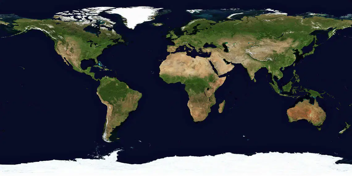
What physical feature is shown in white on this map?
Mountains
Volcanoes
Glaciers
Grasslands

What physical feature is shown in yellow on this map?
Deserts
Volcanoes
Rainforests
Grasslands
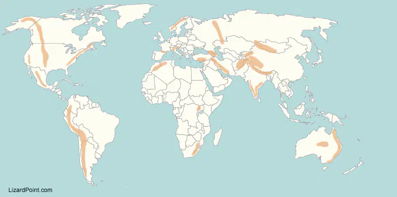
What physical feature is shown in orange on this map?
Deserts
Volcanoes
Rainforests
Mountains
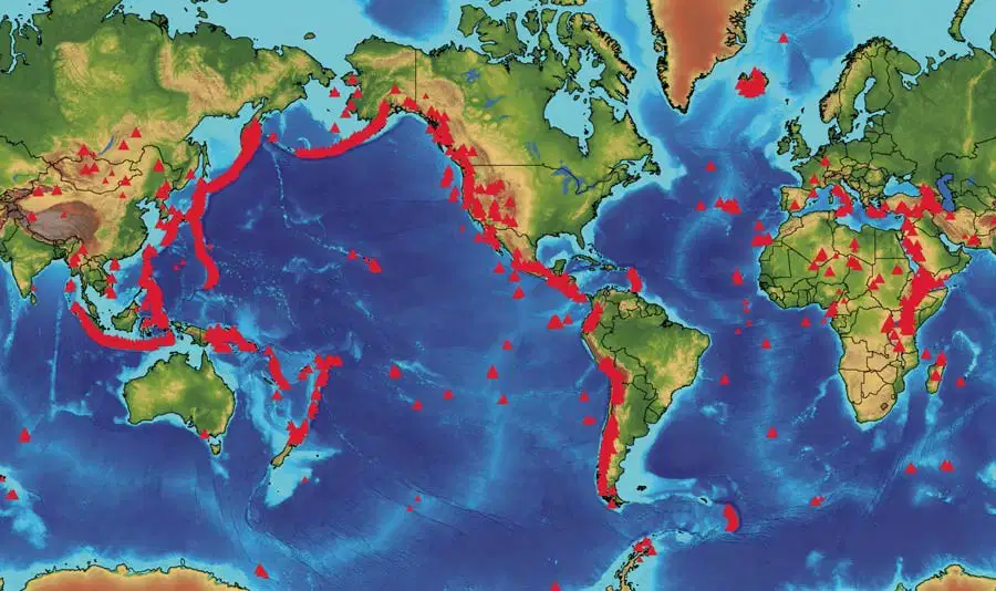
What physical feature is shown in red on this map?
Glaciers
Volcanoes
Rainforests
Mountains
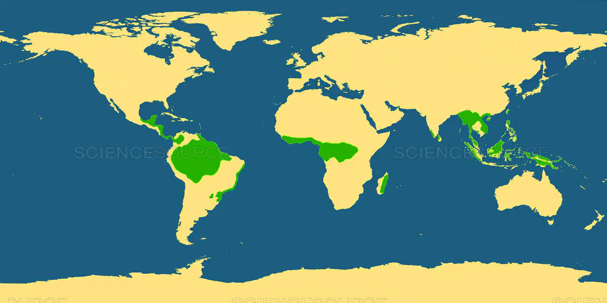
What physical feature is shown in green on this map?
Valleys
Grasslands
Rainforests
Mountains
The type of climate zone we live in.
tropical
temperate
polar

