
Font size
 Worksheets
2025 Semester Exam Review
Total questions: 59
Worksheet time: 40mins
What is the purpose of a map scale?
Explains political boundaries
Identifies natural resources
Shows how distance is represented
Lists climate zones
Which is an example of absolute location?
Near the mall
30°N, 45°W
Across the river
Next to the school
Which statement best describes relative location?
Height above sea level
Position compared to another place
Time zone of a region
Coordinates of a place
Match each map element to its function.
Compass rose
Shows directions
Scale bar
Represents distance
Title
Names the subject
Legend
Explains symbols
Which is the best example of movement in geography?
Rivers carving valleys
Mountains forming slowly
Goods shipped across oceans
Cities increasing population
Which factor helps determine a region’s climate?
Prevailing winds patterns
Natural Resources
Population density
Bordering countries
Which combination lists four climate factors?
Forest cover, industry, sports, tourism
Altitude, money, religion, soil type
Longitude, time zone, rainfall, capital city
Latitude, elevation, prevailing winds, ocean currents
How can natural resources affect economic activity?
More resources always bring wealth
Resources shape industries and trade
Resources stop people from migrating
Resources change Earth’s rotation
Which is a nonrenewable resource?
Coal fossil fuel
Solar panel energy
Timber harvested wood
Wind power energy
Why are places near the poles, like Iceland and Norway, often cold?
High latitude and limited sunlight
Low elevation and heavy rainfall
Warm currents and clear skies
Dense forests and mountains
Which ocean current helps keep Western Europe’s climate milder?
Kuroshio warm current
Pacific Atlantic Drift warm current
North Atlantic Drift warm current
Humboldt cold current
What does the color green commonly represent on a physical map’s land use key?
Desert arid regions
Forest vegetation areas
Urban industrial zones
Agricultural crop fields
Spain and Portugal are located on which peninsula?
Scandinavian peninsula
Italian peninsula
Iberian peninsula
Balkan peninsula
The set that lists major causes of World War I using the acronym MAIN is (a) .
Money, Art, Innovation, Nature
Mining, Agriculture, Industry, Navi
Markets, Armies, Industry, Neutrali
Which statement best explains why Western Europe generally has milder winters than Eastern Europe?
High mountains block Arctic air from reaching cities
The North Atlantic Drift brings warm ocean currents
Cold continental winds from Asia moderate temperatures
Lower elevation across Western plains traps warm air
Why have rivers historically been important in Europe?
They create natural borders for empires
They are navigable for travel and trade
They provide hydroelectric power only
They limit agriculture along floodplains
After World War I, which state disappeared from the map of Europe?
Austria-Hungary
Poland
United Kingdom
Denmark
What was one main reason the European Union was formed in the late 20th century?
To require identical national languages
To restore medieval monarchies
To expand military alliances worldwide
To extend a common economic market
Which explanation best describes why some people risk their lives to migrate to Europe?
To avoid ocean travel and stay inland
To experience colder climates year-round
To find economic jobs and escape unjust governments
To join compulsory military service programs
Which feature best defines a parliamentary democracy in Europe?
Parliament chooses the prime minister
Citizens elect a ceremonial monarch
President leads both lawmaking and courts
Citizens directly elects it's leader
In a presidential democracy, how is the executive leader chosen and related to the legislature?
Directly elected and separate from legislature
Chosen by parliament and must be its member
Appointed by monarch and leads parliament
Selected by courts and can veto elections
Which statement best describes a constitutional monarchy like the United Kingdom today?
Monarch is ceremonial under constitutional limits
Monarch makes laws and runs elections
Military appoints the monarch and cabinet
President replaces parliament and courts
Which mountain range runs along the east coast of the United States?
Cascade Range in Pacific Northwest
Appalachian Mountains along eastern states
Sierra Nevada near California coast
Rocky Mountains along western states
Which North American region is farthest north and surrounds Hudson Bay with rocky terrain and thin soils?
Great Plains with flat grasslands
Canadian Shield with ancient bedrock
Coastal Plain with sandy lowlands
Appalachians with folded ridges
Which region borders the Atlantic Ocean and Gulf of Mexico and has generally warm, humid conditions?
Interior Lowlands with cool summers
Canadian Shield with cold climate
Great Basin with arid deserts
Coastal Plain with low elevation
In the Great Plains, which combination best explains why agriculture thrives?
Infertile soils and high elevation
Fertile soils and moderate rain
Dense forests and heavy shade
Rocky terrain and scarce water
How many Great Lakes are there, and why are they significant?
Four lakes forming only U.S. borders
Three lakes connecting to Pacific Ocean
Five lakes linking Atlantic by St. Lawrence
Six lakes entirely inside Canada
Which landform most often creates a rain shadow that contributes to semi-arid conditions on the Great Plains?
Flat prairies dispersing rainfall
Coastal plains absorbing moisture
Rocky Mountains forcing air uplift
Wide river valleys blocking winds
Which factor most strongly increases population density in North American cities?
Frequent earthquakes and volcanoes
Proximity to water and mild climate
Extreme aridity and sparse rivers
High elevation and rugged terrain
Match each feature to its description.
Appalachian Mountains
Old, eroded ridges in eastern U.S.
Canadian Shield
Ancient bedrock around Hudson Bay
Coastal Plain
Low-elevation land by Atlantic and Gulf
Great Lakes
Five large freshwater bodies on border
Organize these options into the right categories
People have power through voting
Complete Control of country through leader/party with private ownership
Complete Control of country through leader/party with NO private ownership
Germany and Italy are examples
Soviet Union
Power is passed down through family (hereditary)
France and Belgium as examples
Match the following
Militarism
Countries having/wanting more weapons
Imperialism
Expansion of empires
Nationalism
Strong pride in your country
Alliances
Countries agreeing to help protect

What country is highlighted on the map? It was created after WW1 as a buffer between Germany and the Soviet Union?
Austria
Switzerland
Poland
Russia
How did the fall (or end) of communism affect European migration?
People started new businesses instead of moving to another country.
People from Great Britain’s former colonies moved to England.
People had to develop new skills before they could move to another country.
People from Eastern Europe moved to Western Europe.
Which below is an example of how the environment can impact people?
A hurricane that causes flooding and wind damage.
Clearing farmland to build homes
Cutting down tree for lumber
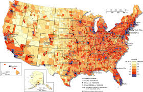
Identify this map.
Population density map
Physical Map
Road map


A map that shows countries, states, cities, borders, boundaries, roads, buildings, etc.
Physical Map
Topographic Map
Geographic Map
Political Map


What is a natural resource?
A nonliving substance found in the environment
A living thing found on Earth
A living or nonliving thing that exists "naturally" in the world
A material that is not normally found in the environment
Click on the map key / map legend.
Click on the compass rose.
Click on the map title.
Match the statement to the correct Topic.
Longitude and latitude
location is a specific point
123 Main St Columbia, SC
a place’s location compared to another place
The Atlantic Ocean is West of Europe
a group of places with common Physical and Human characteristics
the human and physical characteristics of a location which is different/Unique from others
Coastal Plains
The Grand Canyon

The United Kingdom has a King/ monarch and a Prime Minister. What type of government does the United Kingdom have?
Parliamentary Democracy
Constitutional Monarchy
Presidential Democracy
Parliamentary Democracy
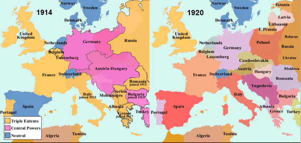
The winning nations in World War 1 redrew the political boundaries of some nations.
Which of the following nations disappeared from the world map at the end of World War 1?
Empire of Austria- Hungary
Czechoslovakia
Poland
Yugoslavia
What climate region is off the coast of California?
Humid Temperate
Humid Cold
Arid
Mediterranean
Cutting down trees and using the wood for camp fire is an example of what theme?
Movement
Place
Region
Human-Environment Interaction
The layout for DMFS is based on the color of the hallway. For example, the blue hall, the purple hall, etc. This is an example of what theme?
Place
Location
Region
Movement
A _________ is made up of both HUMAN and PHYSICAL characteristics that make it unique
Region
Place
Human-Environment Interaction
Location
Match the following peninsula to its location
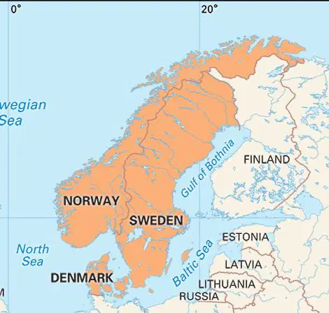
Scandinavia

Iberian

Italian
Match the following
UN
Created to stop wars after WW2
League of Nations
Created to stop wars after WW1
EU
Created to unite Europe economically
NATO
Militarily Unite Western Europe and USA
Warsaw pact
MilitarilyUnite Eastern Europe and USSR
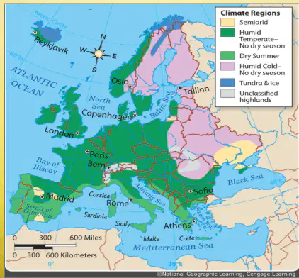
Why is most of Western Europe Humid Temperate but most of Eastern Europe is Humid Cold? (Answer all that apply)
The East is at a higher latitude
Most of the Western is closer to the warm ocean current
Eastern has a continental climate
Eastern is at a higher elevation
There is not a scientific reason why the climates are different.
Which Statements match the climate
Tundra is a cold type
Can form desert landform
Great Plains
SC has this
Mediterranean climate is an example
Long growing seasons and mild winter
Short growing season with mild to hot summers and long winters
Most of Canada
Most of Central america and Caribbean
longest growing season with warm "winters"
Match the statement to Climate Factor
Latitude
Warm at the equator but poles are cold
Elevation
higher altitude = lower temperature
Proximity to water
Further from ocean more extreme seasons
Ocean currents
moves warm/cold water to different areas
Prevailing winds
Winds that move constantly around Globe

