
 Worksheets
Air Traffic Across the U.S.
Total questions: 36
Worksheet time: 18mins

The diagram shows real-time air traffic density across the U.S. at 11:50 AM Eastern with about 4700 planes. Which factor most directly explains the dense clusters over the Northeast and major hubs?
More military training flights than usual
Stronger jet stream pushing planes together
Better radar causing more planes visible
Higher population and major airports concentration
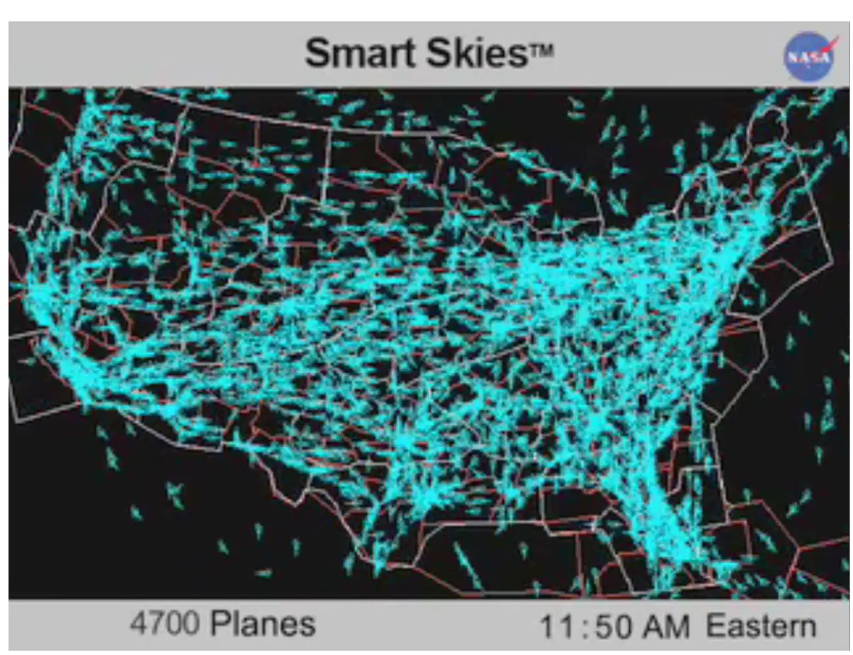
When interpreting a real-time air traffic visualization, what is the safest conclusion about regions showing fewer aircraft markers, such as parts of the Rockies?
Lower airport density and fewer scheduled routes
Terrain and weather limiting flight corridors
Airspace closures always banning civil flights
Time zone differences affecting flight activity
Which description best defines the National Airspace System (NAS)?
A network including airspace and airports
A program limited to pilot training
A single airport control tower
A system only for military flights
Which component is part of the NAS?
Air navigation facilities
Seaport cargo cranes
Highway toll booths
Railway dispatch offices
Match each term with its role in aviation.
NAS
Overall integrated system
ATC facilities
Provide traffic separation
Pilots
Operate aircraft safely
Airports
Enable departures and arrivals
What is the primary purpose of Air Traffic Control (ATC)?
Train new pilots for certification
Inspect aircraft for mechanical defects
Sell airline tickets to passengers
Coordinate aircraft to maintain safe separation
Which organization includes the ATC system in the United States?
Federal Aviation Administration (FAA)
International Civil Aviation Organization
National Transportation Safety Board
Department of Homeland Security
Which tasks would ATC most likely perform during busy air traffic?
Provide altitudes to separate aircraft
Repair navigation radios on aircraft
Authorize taxi routes on the ground
Sequence aircraft for landing approaches
Early aviators primarily relied on what for navigation and separation?
Visual references and lookout
Satellite-based GPS systems
Digital data link clearances
Continuous radar surveillance
What change at some airports in the 1920s helped organize traffic?
Using flagmen for signaling
Installing space-based ADS-B
Building supersonic runways
Creating remote virtual towers
What did the Air Commerce Act of 1926 establish in the United States?
Mandatory pressurized cabins
International flight corridors
A requirement for jet engines
Federal rules for aviation
Air Traffic Control began in 1958 primarily in response to which problem?
Fuel shortages during flights
Runway maintenance delays
Airport noise complaints
A series of mid-air collisions
Which statement best describes Class A airspace as shown in the diagram?
Begins at 18,000 MSL and extends upward to FL 600
Starts at ground level and tops at 1,200 AGL
Encircles small nontowered airports near the surface
Sits only between 700 AGL and 1,200 AGL
In the diagram, which measurement is referenced to the local terrain rather than sea level?
18,000 MSL noted at Class A base
FL 600 noted above the layers
14,500 MSL noted near Class E
700 AGL noted near Class E floor
Match each abbreviation to what it represents.
MSL
Mean Sea Level reference
AGL
Above Ground Level reference
FL
Flight Level reference
Which airspace classes typically form cylindrical shapes around busy airports in the figure?
Class A volumes
Class B volumes
Class C volumes
Class D volumes
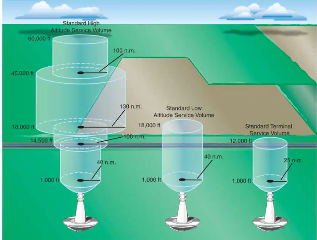
The airport airspace structure is described as an upside‑down wedding cake. What feature in the second diagram illustrates this analogy?
A single uniform cylinder to maximum height
Flat slabs with no lateral change
Narrowing cones that taper toward the top
Stacked, widening shelves at higher altitudes

According to the second diagram, which combination best pairs altitude with the boundary it labels?
18,000 ft marking the top of Standard Low volume
12,000 ft marking the top of Terminal volume
45,000 ft marking the surface boundary line
1,000 ft marking the top of Class A airspace
Which statement best compares MSL and AGL using the first diagram’s notes?
AGL is used only above FL 600 in Class A
Both MSL and AGL are the same reference everywhere
MSL measures from local ground; AGL measures from sea level
MSL measures altitude from sea level; AGL measures from local ground
Which boundary most likely separates Class E from Class G near the surface in the first diagram?
A uniform surface from the ground to 18,000 MSL
A base at FL 600 for low‑level operations
A ceiling at 14,500 MSL everywhere near airports
A floor at 700 AGL or 1,200 AGL depending on area
On aeronautical charts, the federally established routes connecting airports are called what?
Localizer and glide slope paths
SID and STAR procedures
Class B and Class C corridors
Victor airways and jet routes
Which statement best describes a Victor airway compared to a jet route?
Victor airway is only for helicopters
Victor airway is a temporary route
Victor airway serves lower altitudes
Victor airway serves oceanic sectors
Match each airport traffic pattern leg with its typical role.
Downwind leg
Parallel to runway opposite landing direction
Base leg
Turn from downwind toward runway alignment
Final approach
Aligned with runway for landing
Departure leg
Straight course after takeoff
Crosswind leg
Turn to transition toward downwind
Which legs are primarily part of approach for landing?
Departure leg
Final approach
Crosswind leg
Base leg
Downwind leg
During takeoff, which leg aligns straight with the runway as you climb?
Departure leg
Final approach
Base leg
Downwind leg
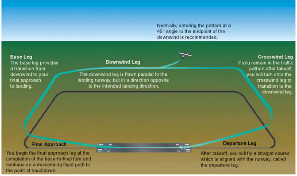
At what recommended angle do aircraft typically enter the midpoint of the downwind leg in the standard pattern?
Forty-five degrees
Ninety degrees
Thirty degrees
Sixty degrees
Which sequence correctly orders the legs from takeoff to landing when remaining in the pattern?
Departure, crosswind, downwind, base, final
Departure, downwind, base, crosswind, final
Departure, base, crosswind, downwind, final
Departure, final, crosswind, base, downwind
What is the main purpose of having a standard five-leg traffic pattern at airports?
Eliminate all holding and sequencing
Provide consistency for approach and departure
Increase runway length for heavy jets
Reduce the need for air traffic controllers
Which statement best distinguishes Visual Flight Rules (VFR) from Instrument Flight Rules (IFR)?
VFR depends on outside visibility cues
IFR depends on pilot seat position
VFR depends on autopilot computer guidance
IFR depends on runway visual markings
International aviation standards developed by the U.S. most directly include which elements?
Procedures for operations
Passenger meal options
Required equipment types
Use of English language
Match each ATC concept to its description.
VFR
Rules using visual references
IFR
Rules using cockpit instruments
ATC System Command Center
Nationwide traffic coordination hub
International standards
Common procedures, equipment, language
Air Traffic Controllers often do not actually see airplanes because they primarily rely on what?
Tower roof visual patrols
Passenger radio reports
Spotting scopes and binoculars
Radar and electronic displays
What is a primary function of the Air Traffic Control System Command Center?
Publishing airline ticket prices
Coordinating national air traffic flow
Maintaining airport ground vehicles
Training new commercial pilots
To balance air traffic across the nation, aircraft may be directed to do what?
Dump fuel before landing
Disable onboard weather radar
Change airline ownership midflight
Speed up or slow down en route
Which pair correctly matches rule type to typical operating condition?
IFR — no radio communications
VFR — instrument-only navigation
IFR — visual clear horizon
VFR — clear weather visibility
Why are international ATC standards important for global aviation?
They allow consistent procedures worldwide
They replace pilot training entirely
They guarantee free tickets for emergencies
They eliminate all flight delays forever

