
 Worksheets
EXAM STUDY GUIDE
Total questions: 69
Worksheet time: 36mins
Maps tend to distort which of the following characteristics?
Shape and elevation
Size and shape
Projections and size
Which of the following is NOT one of the major influencers of a location's climate?
The moon's location in the sky
Latitude
Proximity to water
Islam was founded by the Prophet Muhammad in 610 CE. What century is this in?
5th Century
6th Century
7th Century
Which description best explains how Hinduism and the caste system of ancient India reinforced each other?
Those who follow the Eightfold Path will develop good Karma and be reincarnated into a higher caste.
Hinduism taught that all castes are equal.
Individuals who do their Dharma will acquire good Karma and be reincarnated into a higher caste.
An important difference between Buddhism and Hinduism is that:
Hindus believe in reincarnation… Buddhists believe… saved from eternal punishment
Buddhists believe anyone can achieve enlightenment (Nirvana)… Hindus believe achieving Moksha may require several reincarnations
Hindus rejected priests, rituals, caste system; Buddhists accepted them
Which statement describes the Mandate of Heaven?
Chinese belief that the gods reject bad rulers (through some bad event), and support good rulers and thus dynasties can be overthrown.
Chinese belief that society should be orderly and structured and everyone needs to follow the order of respect.
Indian belief of continual reincarnation until achieving unification with Brahman.
Judaism was unique in that it was the first major religion to:
utilize the caste system.
believe in one, all powerful God.
have written laws as a part of their religious text.
The Islamic Caliphates (ruling entity) combined religious laws into their state government (no separation of church and state). Therefore the Islamic Caliphate was considered:
Democracy
Dictatorship
Theocracy
Which of the following is a key belief, or duty, of Islam?
Sins should be washed away through baptism.
Everyone should worship a picture of Muhammad.
Each Muslim should give to the poor/charity.
Trade in the Indian Ocean relied heavily upon:
The translation abilities of Swahili-speaking merchants.
Seasonal monsoon winds.
The arrival of Portuguese colonists.
Swahili an example of cultural diffusion (the mixing of different cultures) in that it:
Is a blend of African, Middle Eastern and Asian cultures.
Can be written in either Latin or Chinese script.
Originated in the Middle East and spread to East Africa.
Cities or societies that resisted the Mongols as the Mongols expanded their empire were often brutally slaughtered, but cities that surrendered:
Adopted Mongol laws and customs.
Had their children taken away into captivity.
Were forced to pay tribute to the Mongols.
Marco Polo and Ibn Battuta were similar in that they both:
Suffered horrible deaths due to the Black Death.
Wanted to promote their religious ideas and beliefs in radically different cultures.
Traveled extensively in Afro-Eurasia.
A major difference between the Japanese and European feudal systems was:
Peasants/serfs were the largest group in Europe, in Japan it was merchants.
The responsibilities of daimyos and European lords.
The role of knights and samurai
A lasting impact (result) of the Crusades was that:
Christians and Muslims learned to peacefully coexist.
Brought back luxury goods, increased trade.
Europeans kept control of Jerusalem and the Holy Land.
The significant increase in trade experienced in Europe during the High Middle Ages led to:
Spread of other cultures and religions.
Population explosion due to trading foodstuffs
Increased demand for banks as merchants grew.
A significant impact of the Magna Carta in 1215 was:
Kings gained power over taxation and courts
Nobles gained protection of rights such as due process
Peasants received universal voting rights in England
French monarchs were required to obey all English laws
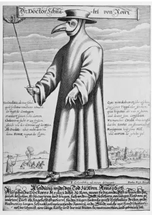
Plague Doctors wore elaborate beaked masks and robes because they believed these outfits:
Signaled royal authority to collect taxes
Safeguarded against bacteria and viruses scientifically
Made enemies fear them on the battlefield
Protected them from miasmas using herbs and flowers
The Ming Dynasty rebuilt sections of the Great Wall primarily to:
Provide new routes for Silk Road caravans
Protect against future Mongol invasions and raids
Serve as a monument to glorify the emperor
Promote northern trade with neighboring states
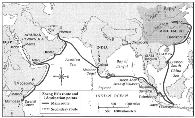
Which audience would most appropriately use a map of Zheng He's voyages (1405–1433)?
Merchants seeking land routes through the Sahara
Modern historians studying destinations and routes
A Song Dynasty historian evaluating expeditions
Zheng He planning another naval voyage
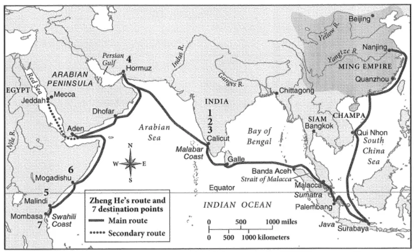
According to Zheng He’s voyage routes, the furthest region he reached was the:
Ming Dynasty interior north of Nanjing
The Arabian Desert near Mecca
East African coast including Mombasa and Mogadishu
The Mughal Empire in northern India
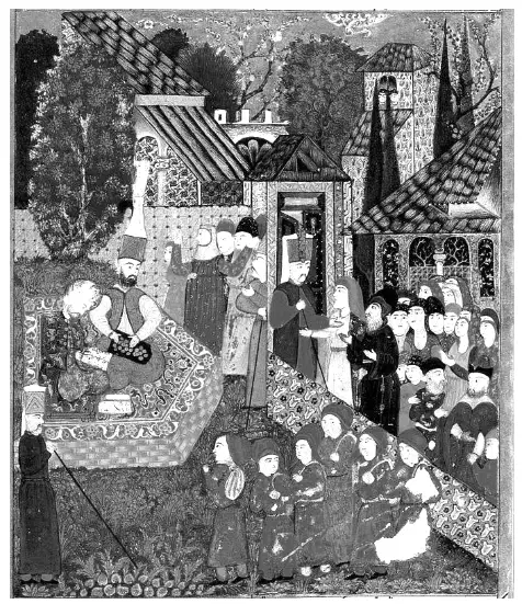
In the Ottoman Empire, the devshirme system involved:
Janissaries marching in ceremonial parades
Boys chosen for Eastern Orthodox priesthood
Christian boys selected for imperial service and training
Merchants recruited to collect provincial taxes
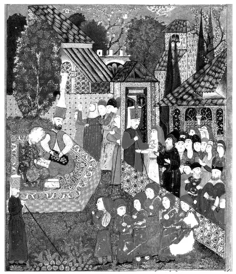
Janissaries represented a fundamental change in Ottoman military organization because they:
Ended the use of firearms in imperial campaigns
Replaced devshirme as a method of coerced labor
Transformed from elite units into larger standing armies
Shifted power to minority groups in government
A core principle of Renaissance Humanism emphasized:
Strict adherence to religious dogma above all
Supremacy of monarchies and absolute rulers
Value of individual experience and classical knowledge
Preference for medieval scholastic debates over science
Which change in Renaissance art most clearly distinguishes it from medieval art?
Only religious themes dominate all paintings
Figures shown flat without human emotion
Using perspective to create realistic depth
Art made only for churches by guilds
Which work is an example of secular art from the Renaissance?
Michelangelo’s Statue of David
Massys’s Lender and His Wife
Leonardo’s The Last Supper
What is the main purpose of the pair of European maps showing printing presses in 1472 and in 1500?
Compare printing press and Reformation
Show growth in printing press locations
Explain fall of feudal manors
Map routes of Italian merchants
How did the printing press most directly affect literacy during the Renaissance?
Books became costly so readers declined
Only religious texts were published widely
Mass production lowered costs and spread literacy
Authorities banned learning outside monasteries
In a 1517 statement, Martin Luther argues the pope has no power to release souls from purgatory. What role best matches the author of that statement?
Merchant angry about church taxes
German prince opposing Luther’s ideas
Catholic cardinal defending indulgences
Monk exposing corruption in indulgences
According to Luther’s criticism, what is the key problem with selling indulgences?
Pope lacks love and avoids charity
Priests cannot pray for the dead
Pope has no authority so payments are useless
Pope has authority but charges a fee
Which was an outcome of Luther’s challenges to the pope and the Catholic Church?
Luther executed by beheading
Return to a single Christian church
Wars of Religion across Europe
Major reforms by Pope Leo X
Which statement best captures a lasting impact of the Scientific Revolution?
Acceptance of the geocentric universe model
Knowledge grounded in superstition and faith
Rejection of scientific instruments and math
Scientific method based on observation and evidence
What social impact did the printing press have as ideas from figures like Galileo and Luther spread?
Ideas challenging authority fueled reform and science
Royal censorship ended permanently
Ideas stayed with a wealthy elite
Religious ideas only were distributed
The Portuguese sought a new sea route to the Indian Ocean in the late 15th century in order to:
Establish diplomatic relations
Bypass Ottoman & Venetian control
Expand Roman Empire
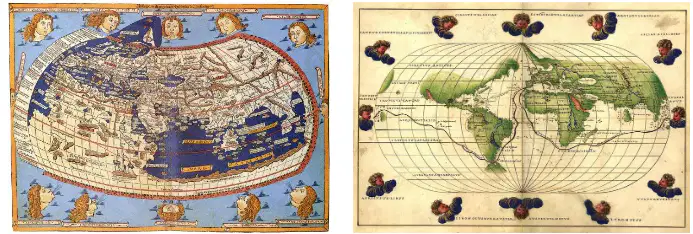
European exploration in the Age of Discovery changed Europeans' understanding of the world in that it:
One large supercontinent
Realization world larger and more diverse
No other civilizations outside Europe/Africa
The primary motivations for Europeans during the Age of Discovery was to:
Expand empires, spread Christianity, gain trade routes/spices/gold
Spread democracy
Settle farming communities
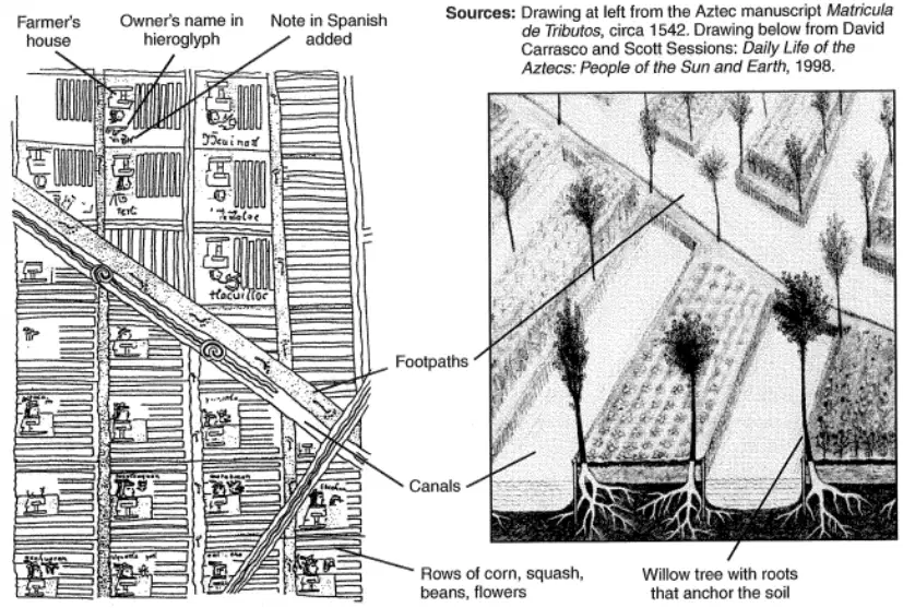
An Intended Audience of the drawing on the left might be:
20th century historians
Spanish crown deciding taxes
Aztec city planners
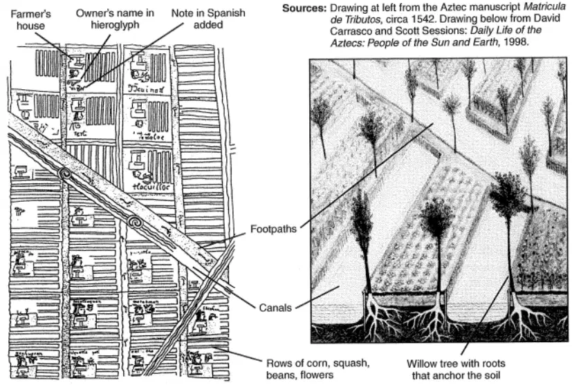
Chinampas were significant to the Aztecs in that the chinampas:
Build cities in mountains
Space for religious ceremonies
Year-round farming using fertile lake land
What is the primary purpose illustrated by the bar graph showing numbers of enslaved Africans imported over successive 25-year periods?
Growth and decline of slave trade over time
Shift from indentured servitude toward slavery
Link between sugar production and slave labor demand
Which explanation best accounts for the noticeable drop in the number of enslaved Africans imported after 1850, as seen in the graph?
The end of the American Civil War immediately halted imports
Legal banning of the transatlantic slave trade by powers
Pirate activity disrupted transatlantic shipping widely
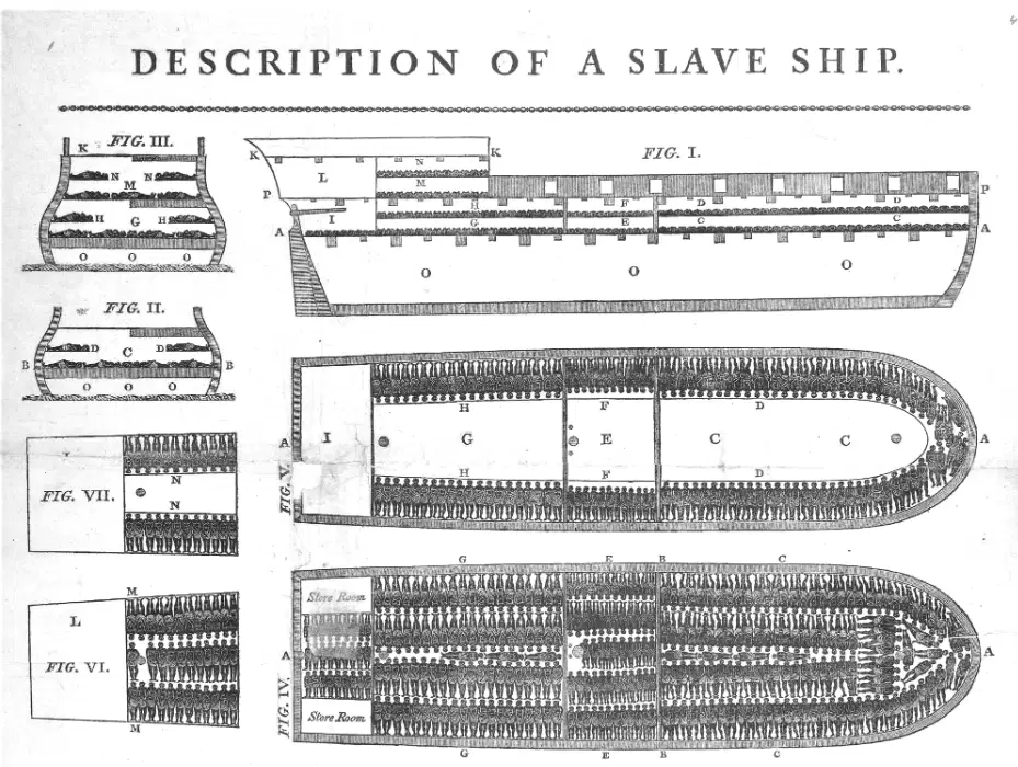
Based on the diagram of the slave ship Brooks, who was the intended audience for this print published with Thomas Clarkson’s abolition work?
Historians primarily interested in naval ship design
Members of the British Parliament debating abolition policies
British citizens who supported continuing slave trade
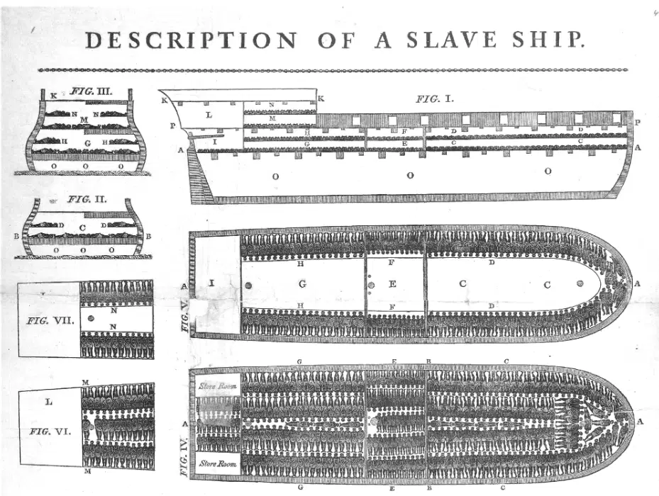
What consequence did the extremely tight packing of enslaved people on ships like the Brooks most directly cause during the Middle Passage?
Little resistance from enslaved passengers overall
High profits with minimal mortality for captains
Frequent disease outbreaks such as dysentery
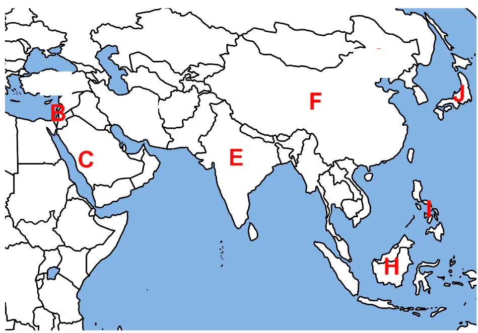
On the Asia map, which labeled location marks Japan?
J on islands east of Korea
F across central and northern Asia
E in South Asia near India
H on Borneo in Southeast Asia
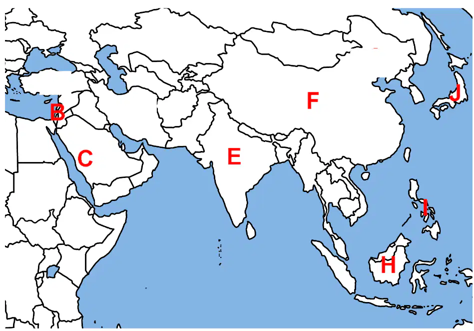
On the Asia map, which label points to India?
J near the Korean archipelago
E on the subcontinent peninsula
C along the Arabian Peninsula
F across Siberia and Mongolia
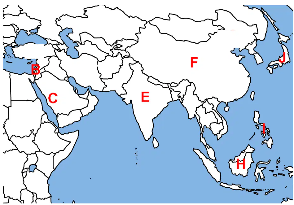
On the Asia map, which labeled location is China?
E on the Indian peninsula
F spanning East and Central Asia
H on Borneo island area
J on the Japanese archipelago
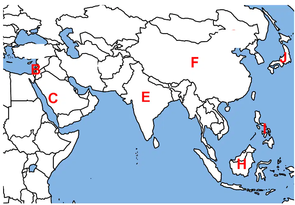
On the Asia map, which label indicates the Philippines?
E on the Indian subcontinent
Small red mark southeast of China
J on the Japanese islands northward
H on Borneo island to the southwest
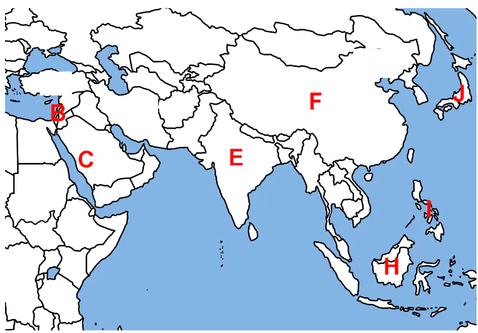
On the Asia map, which labeled location marks Indonesia?
F stretching across northern Asia
E centered on the Indian peninsula
J on islands northeast of Taiwan
H on Borneo within the archipelago
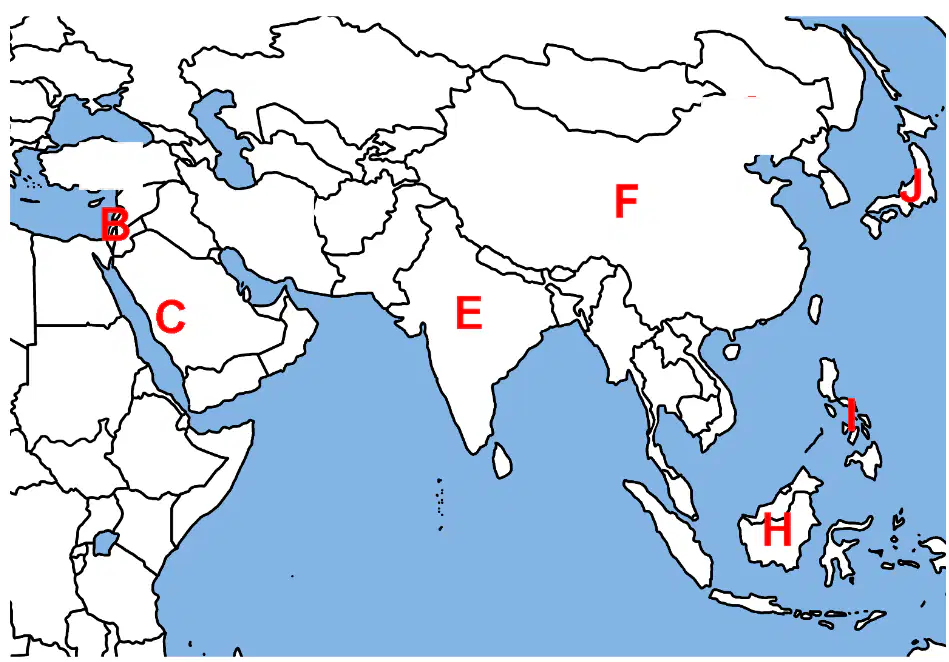
On the Asia map, which letter marks Mecca?
F across northern interior Asia
B near the eastern Mediterranean coast
C on western Arabia near Red Sea
E within the Indian subcontinent
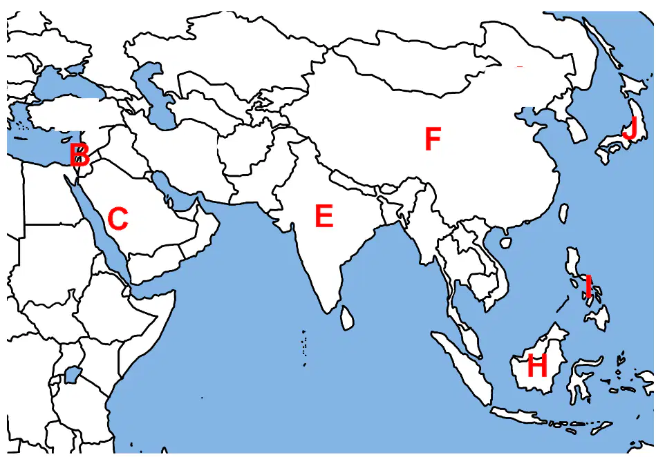
On the Asia map, which label identifies Jerusalem?
B close to eastern Mediterranean shore
C farther south on Arabian Peninsula
E on the Indian subcontinent region
J far northeast in island nation
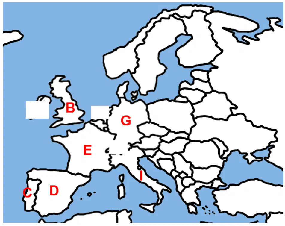
On the Europe map, which labeled location represents Great Britain?
B on the island off Europe’s northwest
E centered in northeastern Spain area
I on the Italian peninsula’s south
G in central Europe east of France
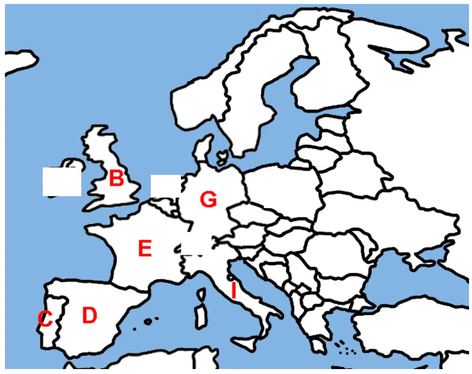
On the Europe map, which label marks France?
E west of Germany bordering the Atlantic
G eastward in central European plains
B offshore island in the northwest
I along the southern Italian peninsula
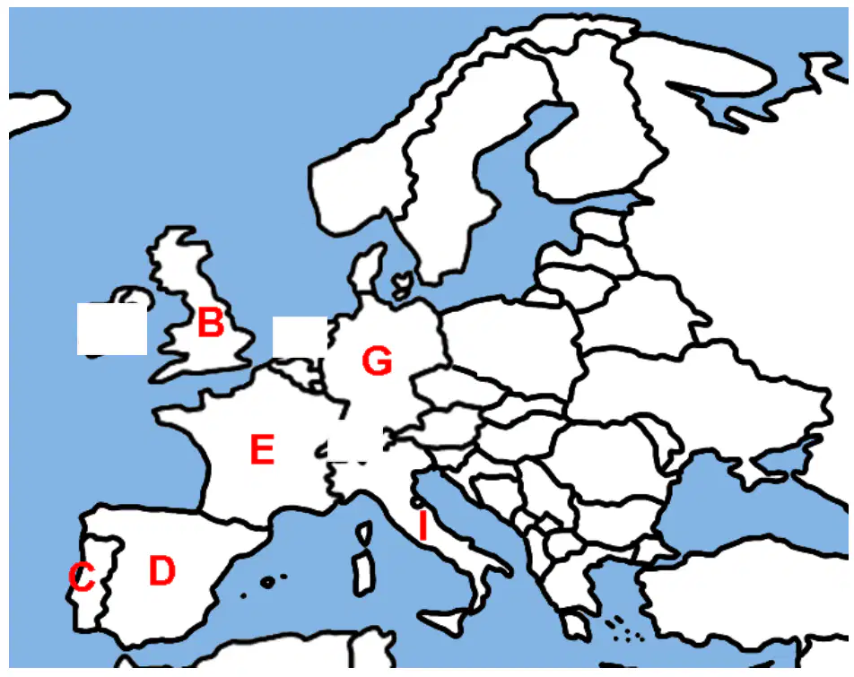
On the Europe map, which label shows Spain?
D across most of the Iberian interior
C on the Iberian west coastline
E in France’s eastern neighbor
I south along Italy’s boot
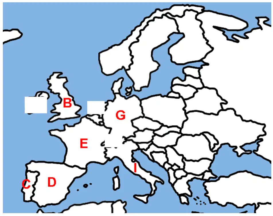
On the Europe map, which label represents Portugal?
G farther east in central Europe
C along Iberia’s Atlantic coastline
E north of the Pyrenees region
D in Iberia’s interior and east
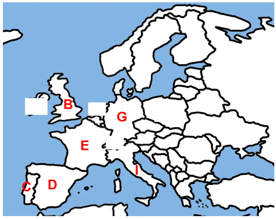
On the Europe map, which label indicates Germany?
I southern peninsula in the Mediterranean
B northwest island nation offshore
E west of Germany near Atlantic
G in central Europe east of France
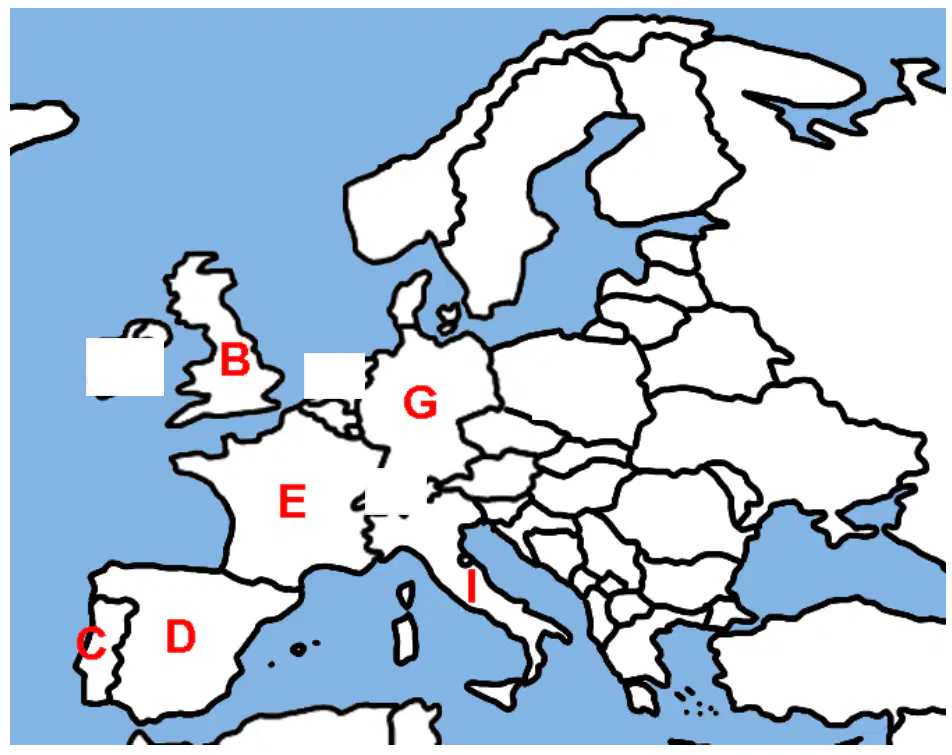
On the Europe map, which label marks Italy?
B island nation to the northwest
I on the southern part of the peninsula
E in France bordering the Atlantic
G east of France in central plains
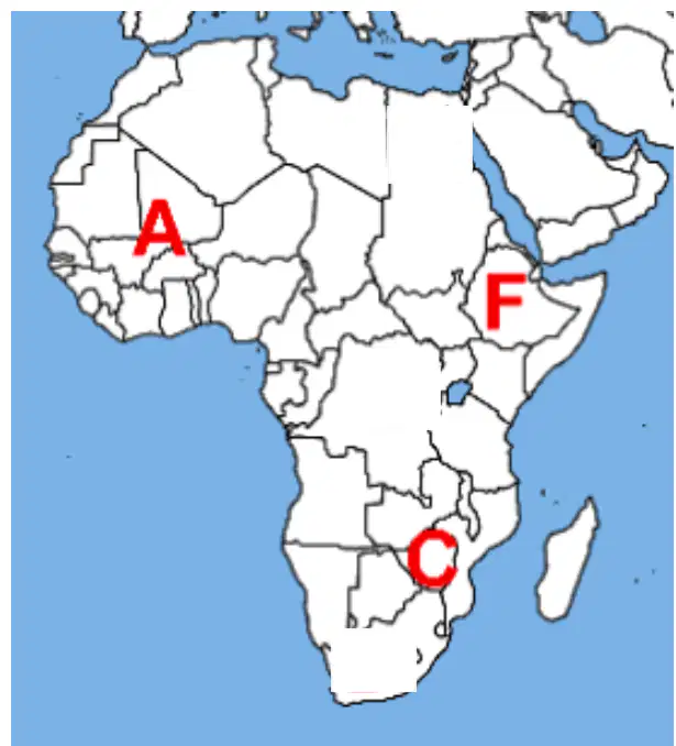
On the Africa map, which label indicates the Mali Empire region?
C in southeastern Africa plateau
A in West Africa near the Sahel
Central belt across equatorial Africa
F in the Horn of Africa highlands
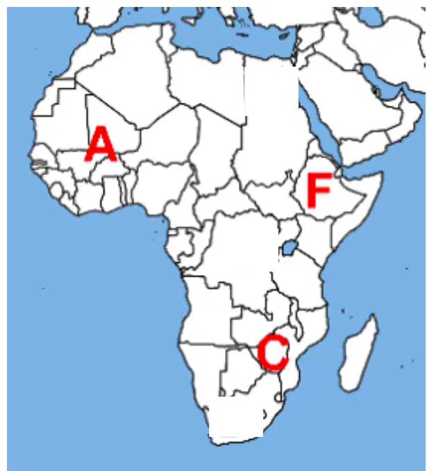
On the Africa map, which label best matches Great Zimbabwe?
Northwest corner near the Sahara
F northeast in the Horn region
A in West Africa along the Sahel
C in southeastern Africa near Zimbabwe
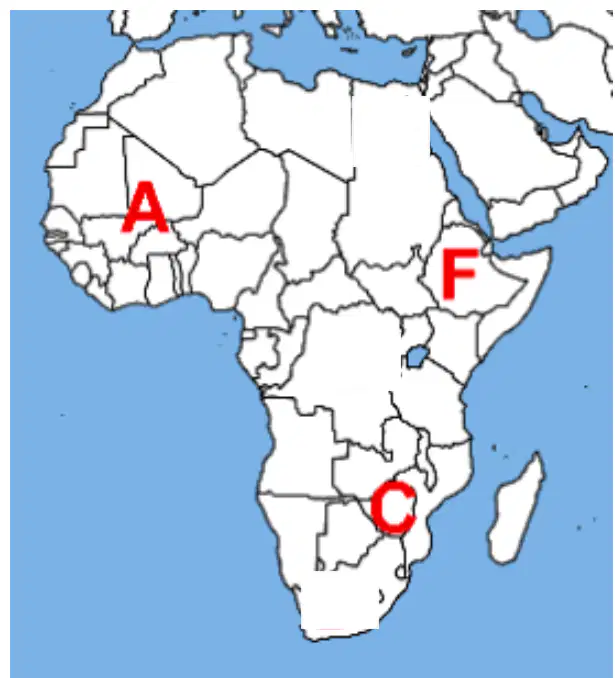
On the Africa map, which label marks Ethiopia?
A in West Africa near Senegal
F in the Horn of Africa highlands
Northern Sahara bordering the Atlantic
C in southeastern African interior
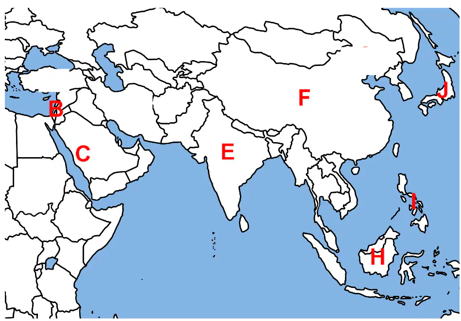
Which letter is India?
C near Red Sea western Arabia
E on South Asian subcontinent
F across northern interior Asia
J island chain in the northwest Pacific
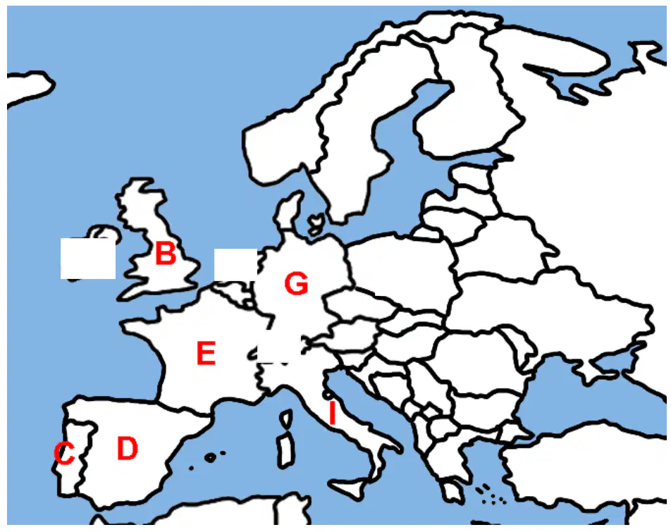
Which labeled European location lies is Germany?
C on Iberia’s western coastline
G in central Europe bordering France
I southern peninsula across the Alps
B island off the northwest coast
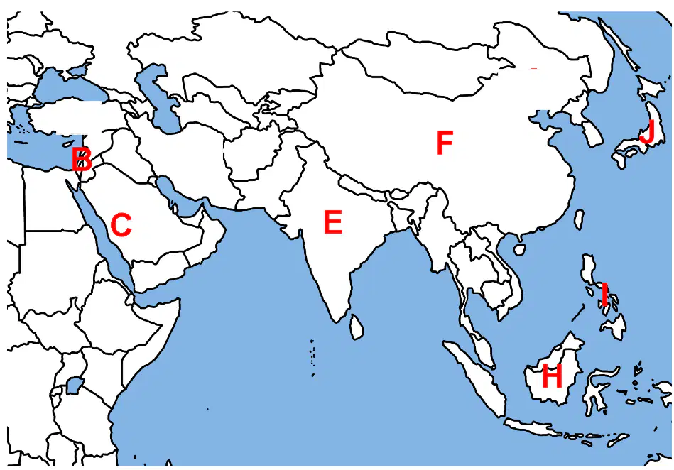
Which labeled Southeast Asian location is Indonesia?
H
J
E
F
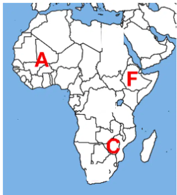
Where is the Mali Empire?
A
C
F
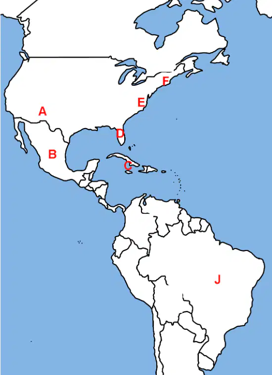
On the map, which labeled region best represents Mexico?
Label D at the Florida Peninsula
Label A in the Southwest United States
Label J in eastern South America
Label B at southern North America
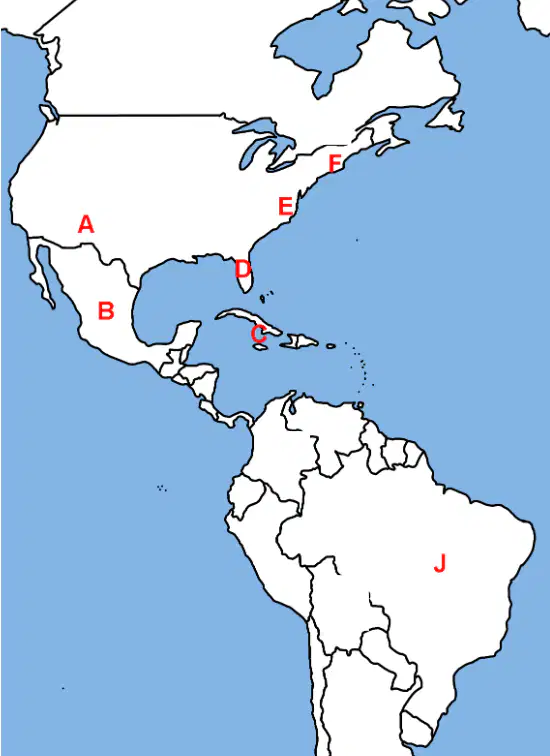
Which labeled area corresponds to New England on the North American east coast?
Label E in the mid-Atlantic coast
Label F in the northeastern coast
Label A in the interior plains
Label D at the Gulf Coast
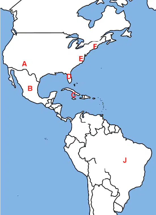
Which labeled country is Brazil in South America?
Label A in the continental interior
Label C in the Greater Antilles
Label B in Central America
Label J in eastern Brazil
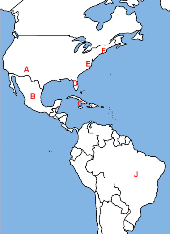
Which label marks Florida on the southeastern United States?
Label B across Central America
Label E along the mid-Atlantic coast
Label D on the peninsula into the Gulf
Label F near the Canadian border
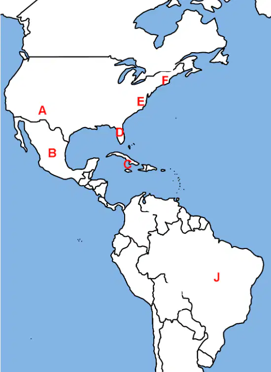
Which labeled colony region is Virginia along the Atlantic seaboard?
Label D on the Gulf peninsula
Label F in far northeast coast
Label A in the western plains
Label E on the mid-Atlantic coast
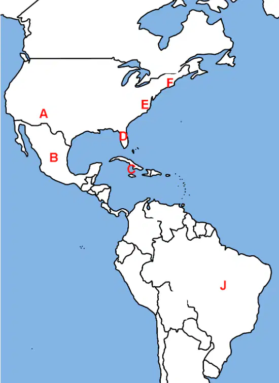
Which labeled area represents the Caribbean islands?
Label C in the island chain
Label B on the Central American isthmus
Label D at Florida peninsula
Label J deep in South America

Which labeled region indicates New Mexico in the American Southwest?
Label F in New England region
Label A in the Southwest interior
Label E in mid-Atlantic coast
Label J in eastern South America

